Jean MASSENET Project Manager CUBE.NC INSIGHT
|
|
|
- Barbara Blair
- 5 years ago
- Views:
Transcription

1 Jean MASSENET Project Manager

2 INSIGHT «Digital Imagery, Geographic Information Systems and High Technologies» WHO WE ARE OUR VALUE-ADDED ROLE APPLICATIONS 2

3 WHO WE ARE 3


4 JEAN DSP : 2 tier III redundant Datacenters SÉBASTIEN Can l: Internet Provider JD Le Cube : Pool of IT engineers A team with internal ressources and worldwide Partners 4

5 FIJI REPRESENTATIVE 5

6 OUR VALUE-ADDED ROLE 6
7 MISSIONS AND COMPETENCES Satellite Imagery Supplier (both Optical and Radar) Satellite, Aerial et UAV imagery Processing Support our customer in expressing their needs & requirements, with Duty of Advise (imagery choice, ground control points positioning, etc.) Creation of dedicated value-added products, solutions and services 7
8 APPLICATIONS 8


9 APPLICATIONS Environnement Territory Management Mines & quarries Crisis Situation Maritime Surveillance Forestry Cartography Geology Natural Hazards Pollution Agriculture Urban Planning Stocks Inventory Ground Mouvements Maritime Monitoring Health Land Registry Environnemental Impacts Bush Fires IUU Fishing Biodiversity Country Planning Deforestation Maritime Rescue Sustainable Development Revegetation Immigration Narco traffic 9


10 MONITOR BURNED AREAS WWW INPUT OUTPUT DIFFUSION Processing INSIGHT : source image ESA - SENTINEL2-24/09/


11 MAKE THE MOST OF YOUR HISTORICAL IMAGERY Historical Aerial Imagery Mosaic Fully Enhanced Noumea 1954 No GCP/metadata (Geomaticians nightmare! ) Processing INSIGHT : source image DITTT Gouv NC
 Fiji-Sentinel")

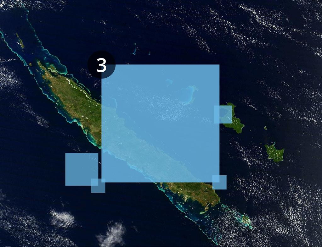
12 GET THE FULL PICTURE Country size Mosaics (Non Commercial/Commercial Imagery) Fiji-Sentinel /2017 New Caledonia -PHR-2017 Processing INSIGHT : source image COPERNICUS, ADS Pleiades VHR 12
13 GET THE FULL PICTURE Processing INSIGHT : source image COPERNICUS 13


14 CREATE REFERENCE DATA Elevation models, Mapping, Feature Exctraction Buildings 1m DTM - DSM Roads Infrastructures Objects Oriented Analysis - Features extraction Malolo Island, Fiji Processing INSIGHT : source image Pleiades VHR Stereo


15 MAP YOUR AIRPORTS AMDB / ETOD Airport Mapping Database / Electronic Terrain Obstacle Data source image ADS Pleiades VHR Stereo


16 IDENTIFY IMPACTS Monitoring of land clearing / deforestation RGB Natural Colors NDVI Vegetation Index Processing INSIGHT : source image ESA - SENTINEL


17 KNOW YOUR RESSOURCES Forestry ressources monitoring / Classification Processing INSIGHT : source image ESA - SENTINEL

18 IDENTIFY SPECIFIC SPECIES Processing INSIGHT : source image ADS Pleiades VHR


19 CHANGE DETECTION IN EMERGENCY CASES Landslide in Wa Wii Lü, New Caledonia Processing INSIGHT : source image ADS Pleiades VHR

20 COASTAL CLASSIFICATION AND MONITORING Processing INSIGHT : source image ADS Pleiades VHR

21 COASTAL CLASSIFICATION AND MONITORING Processing INSIGHT : source image ADS Pleiades VHR

22 KEEP AN EYE ON YOUR EEZ Based on both Commercial & Non commercial Imagery Plane Boat 1 Course Overground: 276,48 Speed: 90,71 Knts Course Overground: 77,52 Speed: 15,11 Knts Course Overground: 117,87 Speed: 23,21 Knts Boat 2 Processing INSIGHT : source image ADS Pleiades VHR


23 ONE IMAGE : SEVERAL APPLICATIONS MARITIME CORAL AGRICULTURE BURN SCARS VEGETATION LAND USE Processing INSIGHT : source image ESA - SENTINEL2-2017
24 CONCLUSION New Caledonian Team with local representative and international partner network Helping you in your projects, from the expression of needs to the delivery of final information Trusted adviser Several topics & applications 24


25 WE NEED YOU!!

26 Jean MASSENET Project Manager