AGROCLIMATIC REGIONS OF RAJASTHAN
|
|
|
- Esmond Stevenson
- 5 years ago
- Views:
Transcription

1 ANNALS OF ARID ZONE Vol. 11, Nos. I & 2, March & June, 1972 AGROCLIMATIC REGIONS OF RAJASTHAN AMAL KUMAR SEN Central Arid Zone Research Institute, Jodhpur ABSTRACT The paper aims at classifying and mapping agroclimatic regions of Rajasthan. To find out the indices to determine the quantitative relation between agricultural production and climate of Rajasthan three methods dealing with the study of the climatic elements, availability of water at various levels and present cropping pattern respectively were studied and different indices for agroclimatic zonation for Rajasthan were worked out. By faithful correlation of these indices the state has been divided and mapped into five macro and ten micro agro-climatic regions. Each region is homogeneous with its own climatic and agricultural peculiarities. INTRODUCTION Influenced by the climate different cultivation units may be recognised and mapped within a single agricultural system. Agroclimatology deals with this problem. It is concerned with the particular differences in local climate of small areas that influence agriculture (Schnelle, 1966). Agroclimatic regions may be defined as the units of homogeneous agricultural fitness as influenced or determined by climate. It is obvious that the characteristics are controlled mostly by topoclimatology, ansmg from topographic characteristics including soil and vegetation (Smith, 1920; Holdefleiss, 1930; Sclianinov, 1937; Burgos, 1958; Saporhnikova, 1962; Burgos, 1966.)

2 32 AMAL KUMAR SEN Framing of such units is of utmost importance to contribute to the increase of agricultural production in arid and semi-arid regions where climate is the most important factor affecting agricultural development. In the present paper an attempt has been made to select agroclimatic indices to classify the state of Rajasthan, which comprises both arid and semi-arid climates into agroclimatic regions. The regions are viewed from the present system of agriculture practises as inflenced by the climate. STUDY & ANALYSIS OF AGROCLIMA TIC INDICES To decide upon the approach to be adopted to classify the agroclimatic regions stresses are laid more on the climatic elements like annual rainfall, temperature and humidity. Cropping patterns are studied next to find out the rei a tionship. It is realised that mean annual rainfall is a very usefull parameter for such classification as a climatic element but additional accuracy and precise information could be obtained by determining the duration and dates of occurrence of the availability of water at various levels of potential evapotranspiratin. Hence the existingirrigational facilities and systems are also to be considered. Complex climatic data, like intensity of sunshine, frost, cloudiness are of little significance in small scale classification for a large area like Rajastnan and these conditions are quite homogeneous here. Accordingly to find out the indices to determine the quantitative relation between agricultural production and climate in Rajasthan the following approaches are made which can be schematically divided into three groups: 1. Methods dealing with the study of the clhnatic ele1l1ents Map 1 shows the outline of the climate of Rajasthan and gives a vivid expression of its regional variation. The map successfully presents the major climatic elements and regional pattern. (a) ANNUAL RAINFALL: The pattern of the isohytes reveals four rainfall belts. (i) 500 to 880 mm towards the east of the Aravallis (ii) Below 100 mm in the extreme west (iii) 100 mm to 300 mm towards the west of the Aravallies (iv) In between i and iii there is another belt lying between 300 mm to 500 mm which stretches from the foothill of the Aravallis in the east to desert plain in the west. The trends of the isohytes are N.E. to S.W. and rainfall gradually decreases from the S.E. to N.W. Thus the lines clearly indicate the little oceanic influence penetrating in the region. The rainfall is however maximum on Aravallis, near Mt. Abu where it exceeds 1000 mm. (b) VARIATION OF RAINFALL : The histograms of the meteorological
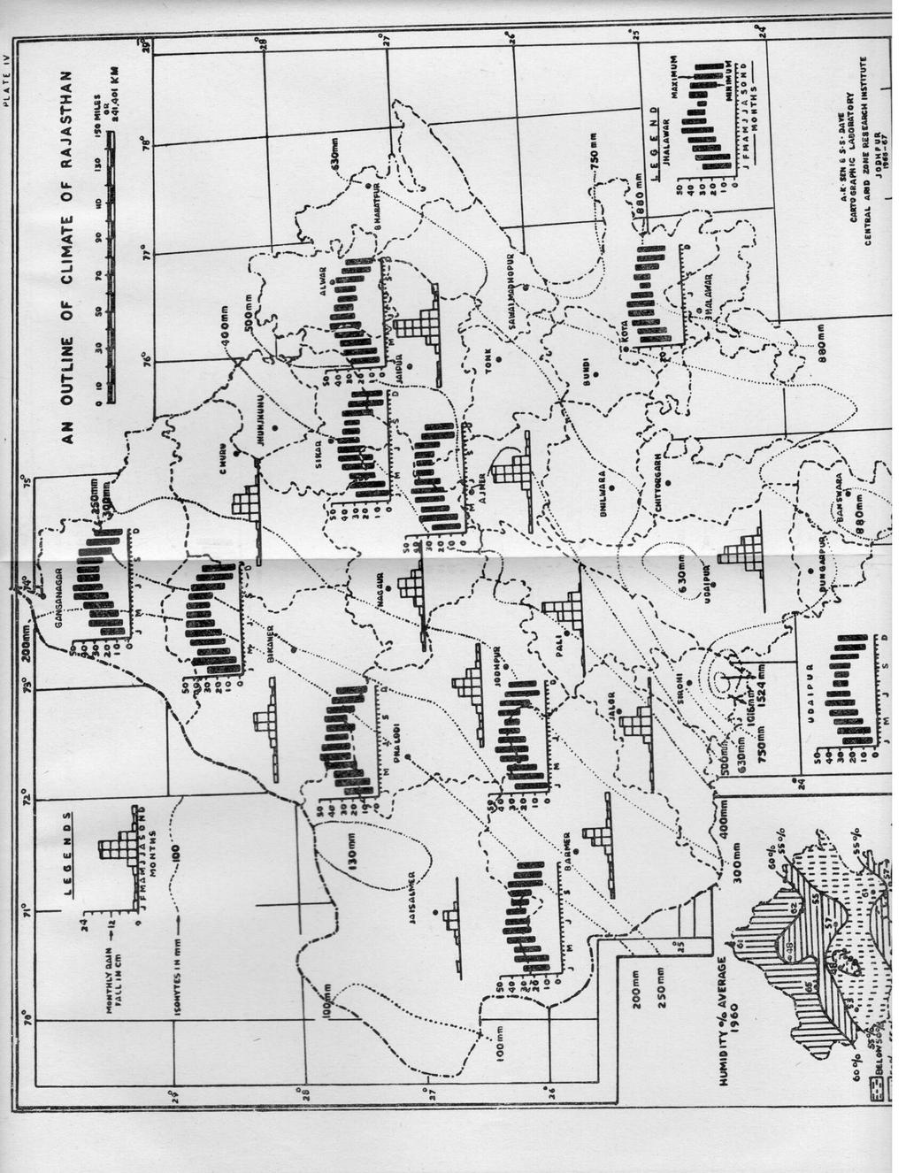
3

4

5 AGROCLIMATIC REGIONS OF RAJASTHAN 33 stations, which are shown in fair distributions in the map, show the monthly variation in rainfall and indicate that about 90 per cent of the rainfall occurs during the monsoon period from June to September. In the winter season the precipitation accounts for 5 per cent from December to February. The frequency of significant rainfall spells (7-10 mm) range from 3 to 6 per month during the monsoon season. (c) TEMPERATURE RANGES AND VARIATION: The tempe~ature graphs of the meteorological stations as shown in the map indicate the monthly distribution of minimum and maximum temperature and its regional variation. In most parts of Rajasthan the summer temperature reaches the maximum during May and ranges from 40.5 to 42 C. During this period the mean minimum temperatures are C. In this season the desert conditions are characterised by heat waves and occasional dust storms. The winter season lasts from December to February. During January the mean maximum temperature ranges from 20 C at Ganganagar to 20 C at Bikaner, 22.5 C at Jaipur and Ajmer, 24.5 C at Jodhpur, Barmer, Jhalawar and to 13.5 C at Kota. Hence during this period temperature increases from north to south. Cold waves commonly occur in the northwestern part of the State. (d) HUMIDITY: The inset map shows the regional variation of humidity (% average). The relative humidity drops down during the summer and increases during the monsoon season, being the lowest in April and highest in August. In general humidity is more in the north and south (above 60%) and less in the centre, near Jodhpur (below 50%).. (e) CLIMATIC REGIONS : A geographic analysis of this climatic map makes it possible for the zonotion of 5 macro climatic regions (Map 2). (i) Arid with annual rainfall 300 mm and less. (ii) Transitional between arid and semi-arid-steppe-annual rainfall between 300 mm to 500 mm. (iii) Semi arid-annual rainfall between 450 mm to 650 mm (iv) Subhumid-annual rainfall between 500 mm to 750 mm (v) Humid-annual rainfall 750 mm and above. It is evident that the above climatic elements are not only responsible for the production of a particular crop but they also significantly control its growing period. 2. Methods dealing with the availability of water at various levels The availability of water which determines the duration and intensity of periods of growth and development of plants is an important aspect of agro

6 36 AMAL KUMAR SEN been taken as the basis provided the sum total of the next two major crops in order does not exceed more than 50 per cent of the total cropped area of the district under consideration. Such a belt is designed as "secondary belt". Bajra belt is the most important, covering per cent of the total area. Other belts distinguished are secondary bajra belt (16.59 per cent), secondary jowar belt (4.08 per cent), maize belt (7.76 per cent) and wheat belt (5.98 per cent). RESULTS Studies carried out and described above present some indices for classification of agroclimatic regions in Rajasthan. Following Burgos (1966) in a modified way they may be grouped into: a) CLIMATIC INDICES i) Annual average temperature ii) Annual range of temperature variation iii) Annual seasonal and highest monthly rainfall iv) Relation between rainfall and temperature. Besides these clementary climatic indices are complex climatic indices like v) Humidity vi) Geographical area of climatic homogeneity or climatic regions. b) CROP INDICES i) Geographical distribution ii) Land use of major crops iii) Crop yield iv) Intensity of cropping v) Geographical area for one crop or group of related crop-crop belt. c) OTHER INDICES i) Availability of water-rainfall and irrigation. Burgos's all the three criterion for agroclimatic descriptions (a) geographical area for one crop or group of related crops, (b) complex agroclimatic indices (humidity) and (c) elementary agroclimatic indices are thus evident in our three groups. AGROCLIMATIC REGIONS OF RAJASTHAN By faithful correlations of the above indices it has been possible to classify Rajasthan State into 5 macro and 10 micro agroclimatic regions. Macro regions are based on temperature, rainfall conditions and distributional pattern of major crops. Cropping pattern and practices, yield, availability

7 AGROCLIMATIC REGIONS OF RAJASTHAN 37 of water and water balance are taken as the basis for framing micro regions within the main units. By and large a' fairly good homogeneity in distribution and practices of crops in their relationship to climate has thus been obtained for each one of the subregions. The macro and micro agroclimatic regions are shown in map 2 and the Table I indicates their agroclimatic peculiarities. The table clearly shows that the regions and subregions identified are homogeneous and indicates the interrelationship between the climate and agriculture. Each region is characterised by its own climatic and agricultural peculiari ties. ACKNOWLEDGEMENT Grateful thanks are due to Dr. T.R. Mehta, Director and Dr. B.B. Roy, Head of Division of Basic Resource Studies, Central Arid Zone Research Institute, Jodhpur for their keen interests in the works. Thanks are also due to Sri S. Dave, Draftsman for his help in cartographical work. The author is also grateful to the participants of U.N.E.S.C.O. Symposium on the methods of Agroclimatology held in Reading (U.K.) July '66 where he was also present as a participant for their valuable suggestions. REFERENCE Burgos, Juan J Tipes agroclimaticos de la palma detilifera en la republica Argentina. Contr b 101 al Congreso Frutinola Arg. Burgos, Juan J World trends in Agroclimatic survey Paper Dl U.N.E.S.C.O. Symp. Methods in Agroclimatology Reading, U.K. Coeheme Jacques 1966 FAO/UNESCO/WMO Agroclimatology survey of a semi-arid area in West Africa south of the Sahara. Paper D3. U.N.E.S.C.O. Symposium Methods in Agroclimatology, Reading, U.K. Holdefleiss, 1930 Agrometeorologie, die Abbangigkeiten der Ernteertage Von Wetterund Klima. 107 pp Ed. P. Parey, Berlin. Kala, T.C Agriculture Recent Dev. Raj. Ministry of Food and Agriculture (Deptt. of Agriculture) pp Krishnan, A Scientific progress report, C.A.Z.R.I. Climatology. pp. 6-7 (for official use). Raheja, P.C. and Sen, A.K Resources in perspective Recent Dev. Raj. Ministry of Food & Agriculture. Deptt. of Agriculture. Souvenir volume pp Saposhnikova, S.A Agroclimatic indices Meteorol'ogical translation. Deptt. of Transp. Met. Branch. pp. 7-74, Toronto.
. Sen, A.K. and Abraham, C.T. 1966 Crop belts and cropp ing pattern of Rajasthan. Ann. Arid Zone. Vol. 5 No.1 pp. 105-116, Jodhpur. Sen, A.K. 1967 Fractional representation in irrigation map.")
8 40 AMAL KUMAR SEN Schnelle, F Agro topoclimatology. Paper D4 U.N.E.S.C.O. Symp. Methods in Agroclimato1ogy, Reading (U.K.) Sclianinov, G.T Mirovoi Agroklimaticheskii spravochinik. (World agroclimatic guide). Sen, A.K. and Abraham, C.T Crop belts and cropp ing pattern of Rajasthan. Ann. Arid Zone. Vol. 5 No.1 pp , Jodhpur. Sen, A.K Fractional representation in irrigation map. Ind. Jr. Geog. Vol. II pp. 1-8, Jodhpur. Sen, A.K Crop yield map of Rajasthan. Deccan Geographer. Vol. VI No.1 Hyderabad Smith, J.W Agricultural Meteorology The effect of weather and crops. Ed. The Macmillan Co. N. York. 304 pp.