UN/Germany Expert Meeting on Space Technologies for Flood and Drought Risk Reduction June 2014, Bonn Germany
|
|
|
- Meagan Webb
- 5 years ago
- Views:
Transcription
1 UN/Germany Expert Meeting on Space Technologies for Flood and Drought Risk Reduction June 2014, Bonn Germany Wazir Khan, General Manager SUPARCO, Pakistan
2 Brief Introduction to SUPARCO Disaster Management Frame Work, Pakistan Role of SUPARCO in Disaster Management Application of Space Technology for Flood Monitoring and Management International Collaboration/Cooperation Conclusions


3
4 Enhance indigenous capabilities in space technology and promote peaceful applications of space sciences for socioeconomic development of the country Prepare and propose long term as well as short term space programs and plans to the government Advise government in all space related matters Liaise with national & international agencies


5 Proposed Space & Atmospheric Research Centre (SPARC) CHINA CHINA Space & Atmospheric Research Centre (SPARC) Swat Gilgit Gilgit AFGHANISTAN Satellite Ground Station Space & Atmospheric Research Station Geomagnetic Observatory Tanda Dam Chashma Barrage Warsak Dam Peshawar ISLAMABAD Tarbela Dam Khanpur Dam Islamabad Rasool Barrage Mangla Dam Qadirabad Kalashah Kako LAHORE Marala Headworks Jammu & Kashmir Space Applications & Research Centre (SPARC) QUETTA Taunsa Barrage Trimmu Barrage Sidhnai Headworks Lahore Balloki Headworks Paksat Ground Control Station L Quetta Multan Punjnad Headworks Islam Headworks INDIA Satellite Research & Development Center TT&C Station for LEO Satellite IRAN IRAN Sukkur Barrage Guddu Barrage INDIA Space & Atmospheric Research Facility, Multan Gawadar Flight Test Range (FTR) Ionospheric Research Facility Sonmiani KARACHI Karachi Kotri Barrage SUPARCO HQs Space Application and Research Wing National Center for Remote Sensing and Geoinformatics COSPAS-SARSAT Geomagnetic Observatory Paksat Ground Control Station K SUPARCO Plant Space Technology Wing Range & Instrumentation Wing Satellite Research & Development Center SUPARCO Institute of Technical Training

 Karachi")
")
6 Atmosphere Data Processing & Receiving Centre (ADPRC) Karachi Satellite Ground Station (SGS) Islamabad

7 Serve as focal office for Emergency OPS & Response in case of Natural Disaster Coordinate with National/Provincial Disaster Management Authorities and other agencies during all phases of disasters Serve as Regional Support Office of UN- SPIDER


8 NDMA Reports SUPARCO National Damage and loss Assessment Reports Record PDMAs Reports DDMAs Reports NEOC Operation Library/National Database Centre Admin NDMA Provincial Damage and Loss Assessment Reports Record Reports Reports Reports Provincial Damage and Loss Assessment Reports Record Reports Reports Reports PDMA PDMA District Damage and Loss Assessment Reports Record Reports Reports Reports District Damage and Loss Assessment Reports Record Reports Reports Reports District Damage and Loss Assessment Reports Record Reports Reports Reports DDMA DDMA DDMA
9 Development of Early Warning System Hazard mapping Identification and mapping of evacuation/safe sites Inventory of population, property, infrastructure, agriculture etc in the hazard prone area Assist NDMA/PDMAs in Risk Assessment and Risk Reductions efforts/projects Preparation of Initial rapid damage assessment reports Monitoring of breaches in embankments/bunds Assist NDMA and PDMAs in preparation of Post Disaster Need Assessment (PDNA) Monitoring of Rehabilitation and Reconstruction Activities Monitoring depletion of glaciers/snow cover/melt


10


11 Flash Flooding Areas Pakistan Riverine Flooding Areas India

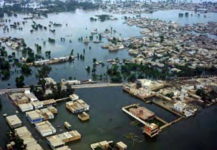
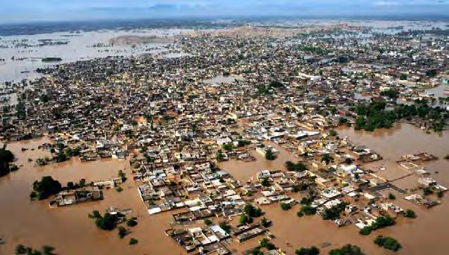
12 12 Extensive riverine inundation and flash flooding in the mountainous regions
13 13 Prolonged rainfall inundations in the lower Indus river region
14 14 Hill torrents and flash floods in the western subcatchments of Indus


15 Pre Flood: 02 June 2010 Post Flood: 12 Aug 2010


16 Pre Flood: 16 May 2010 Post Flood: 13 Aug 2010
17 Preparedness Nation-wide baseline data (LULC) Rapid mapping Development of Flood Early warning system (I-IFAS) Flood-prone area mapping River bank erosion Monitoring snowmelt Rescue and Early Recovery Timely dissemination of information to line agencies Flood monitoring Rapid Damage assessment 2D, 3D visualization Reconstruction & Rehabilitation Detailed damage assessment Monitoring of reconstruction and rehabilitation activities Studying & improving preparedness
18 Preparedness Nation-wide baseline data (LULC) Rapid mapping Development of Flood Early warning system (I-IFAS) Flood-prone area mapping River bank erosion Monitoring snowmelt Rescue and Early Recovery Timely dissemination of information to line agencies Flood monitoring Rapid Damage assessment 2D, 3D visualization Reconstruction & Rehabilitation Detailed damage assessment Monitoring of reconstruction and rehabilitation activities Studying & improving preparedness
19 District boundaries Road network Railroad network Settlements Population Irrigation network Water bodies (rivers, streams, canals, lakes) Dams/Barrages Agriculture Area

20 Completed for Punjab and Sindh Land has been classified into 39 classes Very useful for damage assessment of a particular class such as agricultural land, settlements, woodlands


21 Historical/baseline Data Collection Pre Flood SPOT- 4 & 5 Post Flood SPOT 4 & 5 Aqua & Terra During Flood SPOT 4 & 5 Aqua & Terra Data conversion and standardization GIS Layers Precise Flood extent Daily Flood extent Detailed Damage Assessment Rapid Damage Assessment Templates for dissemination of maps


22 RAPID MAPPING DETAILED ASSESSMENT Quick Response to Disaster Automatic map generation through Custom Developed Software MODIS, SPOT 4, SPOT 5, Vector data Ground surveys Damage Analysis for Infrastructure, Ag riculture, Househ old etc. Detailed Reports

23 Cartographic standards have been prepared for map production Colour-coded Templates for Disaster maps: Earthquake Flood Cyclone Fire Landslide Drought Avalanche

 Flood modelling & hazard mapping Test")
")
24 Project Associates Tarbela Dam SUPARCO/PMD/UNESCO/JAXA Objectives Development of Indus-Integrated Flood Analysis System (IFAS) Flood modelling & hazard mapping Test operation in 2014 Geographic area to be covered by Indus-IFAS (enclosed by dotted lines) Proposed Flood Hazard Mapping Area


25 INUNDATION SIMULATION FOR 2010 FLOODS PROJECT FLOW CHART TRAININGS & CAPACITY BUILDING 04 nominated PMD officials have been enrolled in the 2-year Masters in Geoinformatics program at NCRG, SUPARCO HQ, Karachi. 120 officials from PMD, NDMA, WAPDA, IRSA, FFC, PDMAs, Provincial Irrigation departments and other local organizations were invited for the workshops Flood Risk Mapping using Spatial Technologies from December, 2012 and Safe, Connected communities against floods through RS&GIS tools from March, Trainings for officers of stakeholder organizations. Safe, Connected communities against floods through RS&GIS tools from March, 2014 Opening Address during Safe, Connected communities against floods through RS&GIS tools Chief Guest and speakers during workshop opening session. 14 Dec A view of the participants during technical workshop sessions. 14 Dec


26 Use simulated flood model output for hazard mapping of floodplains. Disseminate maps to federal / provincial flood managers, local administrations and communities. SPATIAL DATABASE FOR FLOOD HAZARD & RISK Following GIS layers were prepared in a buffer of 20km across the Indus River from Kalabagh to Indus River Delta. Settlements Roads FLOOD HAZARD MAPPING VISUALIZATION TOOL Embankments Bridges Irrigation channels Agriculture land FIELD VALIDATION EXERCISES FOR FLOODPLAIN MAPPING

27 TARGET AREA PHASE I TARGET AREA PHASE II

28 Project Associates Study Area FAO/SUPARCO/WAPDA/University of Southampton-UK Objectives Bank erosion modeling of the Indus River( Chashma to Taunsa) Impacts of Flood and bank erosion on agriculture on Indus River Production of an atlas of the spatial and temporal impacts of flood and bank erosion on the River Indus Capacity development of SUPARCO officials

29 Downstream of Sukkur Barrage (Sukkur-Khairpur) Highly vulnerable Moderately vulnerable - Nusrat Loop Bund Highly vulnerabl e Moderately vulnerable Downstream of Sukkur Barrage (Larkana) Less vulnerable - - Ulra Jagir Bund Less vulnerable - S M BUND - - Based on June 2013 and July 2013 images, river course mapping conducted for prediction of vulnerable bunds for forthcoming high flows Image Acquisition: Jun 2013

30

31

32

33

34

35

36

37 Monthly Average Snow Cover (Sq km) During Entire Indus Basin Sq Km January February March April May June July August September October November December
38 Monthly Average Snow Cover (Sq km) During Up-stream Tarbela Sq Km January February March April May June July August September October November December

39 Indus River Monthly Average Flows (m 3 / sec) above Terbela Dam April May Forecast for Year 2013 Expected River Runoff June July m 3 /sec
40 Development of a digital database/inventory of glacial lakes using the satellite data Inventory of Glacial Lakes There are more than 5218 Glaciers in HKH and 2400 plus Glacial Lakes Identification of existing hot spots and potentially vulnerable glacial lakes Identification of areas prone to glacial lake formation

41

42 Preparedness Nation-wide baseline data (LULC) Rapid mapping R&D in Flood Early warning system (I- IFAS) Flood-prone area mapping River bank erosion Monitoring snowmelt Rescue and Early Recovery Timely dissemination of information to line agencies Flood monitoring Rapid Damage assessment 2D, 3D visualization Reconstruction & Rehabilitation Detailed damage assessment Monitoring of reconstruction and rehabilitation activities Studying & improving preparedness

43 MIRA Process & Timeframe Secondary Data within 72 hours Situation overview Satellite imagery and maps showing extent of damages UNOSAT, SUPARCO District Profiles available Govt. Data District Baseline data and MIRA District Checklist Govt. Primary Field Assessment within 1 week Community level assessment KI questionnaire and Direct Observation checklist Identify needs Priority areas (affected ) Vulnerable population

44

45

46

47

48 Preparedness Nation-wide baseline data (LULC) Rapid mapping R&D in Flood Early warning system (I- IFAS) Flood-prone area mapping River bank erosion Monitoring snowmelt Rescue and Early Recovery Timely dissemination of information to line agencies Flood monitoring Rapid Damage assessment 2D, 3D visualization Reconstruction & Rehabilitation Detailed damage assessment Monitoring of reconstruction and rehabilitation activities Studying & improving preparedness
49 Detail Damage Assessment are carried out and reports are provided to NDMA/PDMAs for planning reconstruction and rehabilitation activities and Preparation of PDNAs In the wake of 2010 super flood, the World Bank and Asian Development Bank led the Damage and Need Assessment (DNA) exercise SUPARCO was requested by the World Bank for providing an analysis of flood related damages using satellite imagery and mapping of affected regions Sectors covered were housing, roads, bridges, rail, airports, agriculture and irrigation
50 FAO, UN in collaboration with SUPARCO undertook rapid crop damage assessment in the flood affected districts. This included: Flooded area breakdown by crop and district Date of inundation of affected districts and recession Displaced population in the affected districts and food needs District-wise crops damage statistics were prepared and provided

51
52


53 Regional Perspective of Pakistan Gilgit Indus Flood Plain Chashma Barrage Afghanistan Jhelum river Chenab river Ravi river Sutlej river Quetta Iran Indus river India Indus river Jafaraba d Jacobaba d Sukkur Rahimyar Khan Normal flow S Benazirabad Embankments Karachi Flood /Rain water extent
54

55 Chashma Barrage Approx. 289 Sq.Km Site-1 Approx. 422 Sq.Km Jhelum River Taunsa Barrage Site-4 Hamal lake Approx Sq.Km Approx. 986 Sq.Km Guddu Barrage Site-2 Sukkur Barrage A Site-3 Approx. 156 Sq.Km Approx. 802 Sq.Km Approx. 162 Sq.Km Manchar lake B Chotiari reservoir
 Guddu Barrage Site-2 Ghotki Feeder 75 El Total 65.")
56 Chashma Barrage Indus river Guddu Barrage 77 El Taunsa Barrage 47.84Km Raini Canal (Capacity = 5000 cs) Guddu Barrage Site-2 Ghotki Feeder 75 El Total 65.61Km Hamal lake Sukkur Barrage 72 El Manchar lake Chotiari reservoir 17.77Km Existing canal Potential Reservoir Proposed section 71 El


57 Chashma Barrage Indus river Sukkur Barrage 62 El Rohri canal Total 63Km 55 El 52 El Potential Reservoir Taunsa Barrage 52 El 3-A 48 El Command Area Approx. 986 Sq.Km Guddu Barrage Sukkur Barrage Hamal lake A Nara canal Total Km Manchar lake B Site-3 Chotiari reservoir 31 El Existing canal Potential Reservoir 21 El Proposed section Potential Reservoir 3-B Thar
58
59 Preparation of inventory of Landslides for the north part of the country Identification and mapping of Landslide prone areas Identification and mapping of Earthquake Prone areas Preparation of Guide maps for Vulnerable Communities of the disaster prone areas Development of Flood model for eastern rivers of the country Preparation and Production of Risk Maps Capacity Development of NDMA and PDMAs for application of space technology for disaster management

60 On Behalf of NDMA, SUPARCO has been registered with Charter as Authorized user SUPARCO is host to UN-SPIDER Regional Support office in Pakistan SUPARCO is the Member of JPT-3 of Sentinel Asia. Applied for Registration as DANs
61 Due to consecutive floods for the last four years, we have developed expertise to mitigate the affects of floods using Remote Sensing and GIS Technology. However, we are looking forward to learn from the experiences and best practices of other countries/ organizations to improve our systems. We have no considerable expertise/experience in application of Space Technology for Drought monitoring or early warning and looking forward to learn from Tomorrow s sessions on the subject. International/bilateral cooperation among countries, regional and international organizations needs to be enhanced to better manage natural disaster mitigation and relief efforts using space technology. SUPARCO shall keep to support all regional and international efforts initiated for minimizing the damages and sufferings face by mankind in the event of natural disasters


62 62