National Drought Monitoring in Canada
|
|
|
- Gilbert Simpson
- 5 years ago
- Views:
Transcription
1 National Drought Monitoring in Canada Trevor Hadwen Agriculture and Agri-Food Canada, Agri-Environmental Services Branch (AESB) National Agroclimate Information Service (NAIS) Manitoba, DRI Workshop Winnipeg, January 13, 2010
2 Key Indicators for Monitoring Drought climate data (precipitation, temperature) soil moisture stream flow ground water reservoir and lake levels snow pack short, medium, and long range forecasts vegetation health/stress and fire danger sectoral impacts 2


3 Drought Watch Website 3

4 National and Regional Products Canada is broken down into 5 regions 4
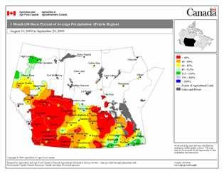
5 Time Specific Products Agricultural year Growing season Winter season Percentiles Percent of normal Accumulated PPT Departure from average 5

6 National Drought Model: SPI, PDSI and Modeled Soil Moisture 6
7 Prairie Drought Impact Monitoring On-Farm Surface Water Supply and Forage Monitoring Program Forage Production Forage Supplies On-Farm Surface Water Supplies 7
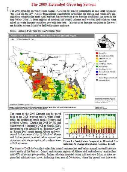
8 Quantifying the Impacts of Drought 8

9 Quantifying the Impacts of Drought Forage Production Potential Percent of Prairie Agricultural Area 57% 100% 80% 60% 40% 20% Forage Production Potential Percent of Prairie Agricultural Area 25% 18% 0% M ay 1 Jun 1 Jul 1 Aug 1 Sept 1 Oct 1 Nov 1 Forage Production Potential Percent of Farms Forage Production Potential Percent of Farms 54% 100% 80% 60% 40% 20% 29% 17% 0% M ay 1 Jun 1 Jul 1 Aug 1 Sept 1 Oct 1 Nov 1 Forage Production Potential Percent of Cattle 54% 100% 80% Forage Production Potential Percent of Cattle 60% 40% 20% 27% 19% 0% M ay 1 Jun 1 Jul 1 Aug 1 Sept 1 Oct 1 Nov 1 9
 spatial extent and impacts Assessment of current conditions Incorporate local expert input Objective as")
10 International Collaboration and Drought Analysis A consolidation of indices and indicators into one comprehensive national/continental drought map Tries to capture the drought s magnitude (duration + intensity) spatial extent and impacts Assessment of current conditions Incorporate local expert input Objective as possible 10


, and a wide")


11 NADM Monthly Assessments Monthly assessments are based on a wide range of products at national, provincial and regional scales. The data consists of near real time monitoring (AAFC and others), maps from the national drought model (AAFC), and a wide variety of provincial/regional products. Assessments also use many conditions reports from other agencies including provincial crop reports, stream flow reports, low water level advisories. 11
12 Traditional Remote Sensing-Based Drought Monitoring 1. Normalized difference vegetation index (NDVI), which provides a general measure of the state and health of vegetation, was one of the first remote sensing-based indicators used for drought detection and monitoring. NDVI data calculated from AVHRR observations provides national scale information on a weekly basis that was optimal for this type of applications. Drought impacted area in 2002 Courtesy of NASA 12


13 MODIS - Remote Sensing Products: Weekly MODIS NDVI 7-day composites Advantages of the MODIS System National Coverage Better resolution Better analytical features Data is free of charge from USGS Data back-up system is incorporated Opportunity to use other Indices 13


14 SSMI Special Sensor Microwave Imager 14
 integrates both NDVI- (VCI Vegetation Condition Index) and thermal-based (TCI Temperature Condition Index) indicators")
 & TCI (Temperature Conditions Index)")
15 Improved Remote Sensing-Based Drought Monitoring 2. Vegetation Health Index (VHI) integrates both NDVI- (VCI Vegetation Condition Index) and thermal-based (TCI Temperature Condition Index) indicators derived from AVHRR data to depict drought stress as function of vegetation canopy greenness and temperature. VHI = a * VCI + b * TCI a * & b * = coefficients to quantify share of NDVIbased VCI (Vegetation Condition Index) & TCI (Temperature Conditions Index) contribution in total vegetation health. Global products generated weekly by NOAA. p 15
 observations provide spatially detailed information regarding the general state and condition of vegetation.")
 - Palmer drought severity index (PDSI) Environmental characteristics that influence")

16 VegDRI An Integrated Approach Remote Sensing Component Climate Component Biophysical Component + + Satellite-based 1-km NDVI (normalized difference vegetation index) observations provide spatially detailed information regarding the general state and condition of vegetation. Variables: - percent annual seasonal greenness (PASG) - start of season anomaly (SOSA) Measure of broad scale geographic patterns of dryness. Variables: - standardized precipitation index (SPI) - Palmer drought severity index (PDSI) Environmental characteristics that influence climate-vegetation interactions. Variables: - land use/land cover type - soil characteristics - elevation - ecological setting Brown, J.F., B.D. Wardlow, T. Tadesse, M.J. Hayes, and B.C. Reed, The vegetation drought response index (VegDRI): a new integrated approach for monitoring drought stress in vegetation. GIScience and Remote Sensing, 45(1):

17 17
18 Vegetation Outlook ( VegOut) A new experimental tool that provides a series of maps depicting future outlooks (2 to 6 weeks) of general vegetation conditions (seasonal greenness) based on an analysis of: 1) satellite-based observations of vegetation 2) climate-based drought indices 3) general biophysical characteristics of the environment 4) oceanic indicators. 18

19 Challenges for Drought Monitoring in Canada Canadian environment is complex and drought indices need to be utilized in a way that reflects this. Increased need for timeliness and accuracy in determining extent location and severity of climate impacts. Quality and quantity of data is incomplete. Data density and length of record are both significant challenges. Uncertainties exist in index calculation, mapping and interpretation. Testing and calibration should be encouraged Winter (Snow) Hard to measure, it tends to move around before the moisture is accessible (Blowing, runoff, sublimation). Indices do not account for this. 19

20 Potential Data Untapped Data Options New sources of data from: Private networks i.e. the Weather Innovations (WIN) and the Weather Bug. Provincial seasonal networks - i.e. agriculture and forestry departments New projects such as Crop Insurance Weather Derivatives 20


21 Blended Indicators Similar to USDM Objective Blends, but with different components and possibly different weights Short-Term Blend 35% Palmer Z Index 25% 3-Month Precip. 20% 1-Month Precip. 13% CPC Soil Model 7% Palmer Drought Index Would need serially complete data, so could not be computed on station data Long-Term Blend 25% Palmer Hydro. Index 20% 24-Month Precip. 20% 12-Month Precip. 15% 6-Month Precip. 10% 60-Month Precip. 10% CPC Soil Model 21
22 Monitoring Outside the Agricultural Extent, Especially in Northern Extremes Lack of station data for northern regions. Lack of understanding of drought assessment and drought issues in northern areas, especially north of the treeline. Research is required on how to address these issues. First priority is to improve monitoring in the boreal regions. We need to develop relative indicators for northern regions. CFS currently uses Absolute indicators. Remove sensing may be able to assist in some regions. 22
23 Active Hydrometric Stations 23
24 What do the indices tell us? We need to better understand how to assess drought regionally, including in northern Canada. Most indicators/indices are not locally calibrated. At a WMO meeting in December there was a resolution put forward for the SPI to be used as universal metrological drought index. However the group could not reach consensus on agricultural or hydrological indices. The WMO called for more study on these indicators. 24
 Key Clearinghouse Functions: Credible, Accessible, Timely Information on Where are")

25 The NIDIS U.S. Drought Portal ( Key Clearinghouse Functions: Credible, Accessible, Timely Information on Where are drought conditions now? Does this event look like other events? How is the drought affecting me? Will the drought continue? Where can I go for help? Portlet example: NWS River Forecast Center Ohio River Water Resources Outlook- Ecosystem recovery 25
26 Thank You Trevor Hadwen
27 27
28 Vegetation Drought Response Index (VegDRI) VegDRI is a new hybrid drought index that integrates: - satellite-based observations of vegetation conditions - climate-based drought index data - biophysical characteristics of the environment to produce 1-km spatial resolution maps that depict drought-related vegetation stress. Operational production of VegDRI maps for the continental U.S. once every two weeks across the year. In 2010, production will transition to weekly updates using MODIS data inputs. 28
29 Background The NADM is a cooperative effort between drought experts in Canada, Mexico and the United States. The objective is to monitor drought across the continent on an ongoing basis. Initiated at a workshop 2002 and is part of a larger effort to improve the monitoring of climate extremes on the continent and to provide an ongoing comprehensive and integrated assessment of drought The NADM has been delivering monthly assessments of drought severity on since March

30 The Cycle of Disaster Management 30
31 Near Real Time Monitoring Station Coverage Mapped NRT stations = 508 Complete List of NRT Stations = 761 Maps include: - % of normal ppt - Percentile ppt - Accumulated ppt 31
 PDI Palmer Z Moisture")
32 The National Drought Model Station Coverage The National Drought Model: Drought Model Stations for April 2007 = 874 Standardized Precipitation Index (SPI) From 1 month to 5 years Soil Moisture Percent of Average Difference from Normal Total Soil Moisture Has the ability to do future projections Palmer Drought Index (PDI) PDI Palmer Z Moisture Anomaly 32
33 Drought more than just lack of rainfall Drought can mean many different things to different people Depending on: A regions normal climate Specific needs of various sectors Main categories of drought are meteorological agricultural hydrological socioeconomic Most Drought indices measure meteorological drought The availability of water depends largely on rainfall, (but) the concept of drought cannot be divorced from the use to which water is put. Gibbs & Maher (1967): 33