WHERE HAVE ALL THE CROP ACRES GONE?
|
|
|
- Kimberly Allen
- 5 years ago
- Views:
Transcription


1 WHERE HAVE ALL THE CROP ACRES GONE? Bryce Larson, Calumet County UW Extension Agriculture Educator Special thank you to Connie Leonhard our program assistant for her talents and assistance with this project October 21, 2010
2 How this project began Mary Kohrell, Calumet County UW Extension Resource Development Educator, invited me to attend a Calumet County Working Lands Committee Meeting, and that is the event that triggered my interest in researching information and data that resulted in the following presentation.
3 Farm Land Disappearance Nationwide From 1964 to 2007 the United States lost 188,092,000 acres of land in farms or the equivalent of 5.3 states the size of Wisconsin. During that time the US also lost 27,808,000 acres of crop land but showed an increase of 22,716,000 acres of the crop land available that was harvested.
4 Time Line and Selected States I will be using data and information from the Ag Census data for the remainder of this summary on the disappearance of farm land, crop land, and harvested crop land from the IA, IL, IN, MI, MN, and WI and the selected counties I have chosen to highlight.
5 Animal Unit Statistics I am also using Ag Census data to calculate the 1,000 lbs. animal units (AU) in each state and the changes in numbers from For these calculations I have included dairy and beef cows, heifers and feed lot animals, swine inventory herd, hogs fed and slaughtered, laying hens, and broilers or meat birds. I am using the NRCS animal unit conversion numbers to equate the various animal units to 1,000 lbs. unit increments that are used for converting varying animal species to a standardized number.
6 US and Selected States Population I am using the April 2008 US, state, and county population data to calculate the human populations and the per capita calculations on land lost from farms, crop land, and harvested crop land. The United States in 2008 was estimated to have 304 million citizens which translates into 80 persons per square mile.
7 Farm Land Loss Trends As one reviews the data from the US and the six states including Wisconsin, there are some trends that become very evident. The majority of land in farms lost in the US occurred from 1964 to Good quality crop land in the US and in most states is continuing to disappear and at faster rates than land in farms is disappearing. This would indicate that good crop land is being utilized for other types of developments and usage. that is unsuitable for cropping is in many cases unsuitable for many other uses. continues to increase in the five states with the exception of Wisconsin. To me this means that our remaining crop land is being utilized more intensively and to grow either wheat or row crops such as corn and soybeans.
8 USA Farmland loss (continued) Wisconsin has had the largest loss of land in farms, crop land and is the only state of the 6 that has lost harvested crop land over the last 20 years. Not only have we lost the highest percentage of farm land and crop land we have lost the most absolute acres of crop land. Only Michigan has fewer crop acres than Wisconsin yet we lost 1.5 million acres of crop land over the last 20 years. Some our neighboring states have twice as many crop acres as does Wisconsin and yet lost less total crop land. On a per capita basis Wisconsin consumes land in farms and crop land at many fold the rate of our neighboring 5 states.
9 Wisconsin 18,000,000 16,000,000 14,000,000 Loss of 1,416,000 acres 8.51% Crop land Loss of 1,502,000 13% 12,000,000 10,000,000 Loss of 454,000 acres 4.84% 8,000,000 April 2008 population estimate 5.63 million 99 persons per square mile 6,000,000
10 Minnesota 30,000,000 28,000,000 26,000,000 Gain of 344,000 acres +1% Crop land Gain of 72,000 acres +.003% 24,000,000 22,000,000 20,000,000 Gain of 2,632,000 acres +15.8% April 2008 population estimate 5.2 million 62 persons per square mile 18,000,000 16,000,000 14,000,000
11 Iowa 34,000,000 32,000,000 30,000,000 Loss of 891,000 acres 2.82% Crop land Loss of 974,000 acres 3.57% 28,000,000 26,000,000 24,000,000 Gain of 3,315,000 acres +16% April 2008 population estimate 3,002, persons per square mile 22,000,000 20,000,000 18,000,000
12 Illinois 30,000,000 28,000,000 26,000,000 Loss of 1,751,000 acres 3.3% Crop land Loss of 1,395,000 acres 5.56% Gain of 2,509,000 acres +12.5% 24,000,000 22,000,000 20,000,000 April 2008 population estimate 12,904, persons per square mile 18,000,000
13 Michigan 11,000,000 10,000,000 9,000,000 Loss of 285,000 acres 2.8% Crop land Loss of 378,000 acres 4.6% Gain of 687,000 acres +11% 8,000,000 7,000,000 6,000,000 April 2008 population estimate 10,003, persons per square mile 5,000,000
14 Indiana 17,000,000 16,000,000 15,000,000 Loss of 1,397,000 acres 8.7% 14,000,000 Crop land Loss of 650,000 acres 6.5% Harvested crop acres Gain of 1,402,000 acres +9.4% April 2008 population estimate 6,376, persons per square mile 13,000,000 12,000,000 11,000,000 10,000,000


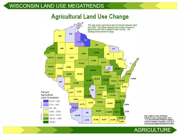
15 Wisconsin County Map
16 Brown County, Wisconsin 240, , ,000 35,000 acres lost 15.8% Crop Land 47,000 acres lost 22.8% 34,000 acres lost 19.7% 180, , ,000 Population 245,000 Per square mile ,000
17 Calumet County, Wisconsin 180, , ,000 18,000 acres lost 10.7% Crop Land 15,000 acres lost 10.4% 150, , ,000 9,000 acres lost 7% 120, ,000 Population 45,000 Per square mile ,000
18 Clark County, Wisconsin 500, , ,000 5,000 acres lost 1.2% Crop Land 16,000 acres lost 5.2% 15,000 acres gained +6% 350, , ,000 Population 34,000 Per square mile ,000
19 Dane County, Wisconsin 600, , ,000 34,000 acres lost 6% Crop Land 58,000 acres lost 12% 2,000 acres lost 1% 450, , ,000 Population 483,000 Per square mile ,000
20 Dodge County, Wisconsin 460, ,000 54,000 acres lost 12.4% Crop Land 25,000 acres lost 6.9% 4,000 acres gained +1.2% Population 88, , , , , , , ,000 Per square mile ,000
21 Dunn County, Wisconsin 450, , ,000 17,000 acres lost 4.25% Crop Land 20,000 acres lost 7.4% 3,000 acres lost 1.5% 300, , ,000 Population 43,000 Per square mile ,000
22 Fond du Lac County, Wisconsin 380, , ,000 23,000 acres lost 6.4% Crop Land 21,000 acres lost 9.1% 320, , ,000 13,000 acres lost , ,000 Population 109,000 Per square mile ,000
23 Jefferson County, Wisconsin 270, , ,000 12,000 acres lost 4.7% Crop land 17,000 acres lost 8.2% 3,000 acres gained , , ,000 Population 81,000 Per square mile ,000
24 Lafayette County, Wisconsin 400, , ,000 30,000 acres lost 9.1% Crop land 44,000 acres lost 15% Harvested crop acres 8,000 acres lost 2.3% Population 16, , , , , , , ,000 Per square mile ,000
25 Manitowoc County, Wisconsin 290, , ,000 29,000 acres lost 10.5% 230,000 Crop land 36,000 acres lost 15.3% 29,000 acres lost 13.3% 210, , ,000 Population 81,000 Per square mile ,000
26 Marathon County, Wisconsin 600, , ,000 91,000 acres lost 15.7% 450,000 Crop land 43,000 acres lost 11.8 % 13,000 acres lost 4.3% 400, , ,000 Population 131,000 Per square mile ,000
27 Outagamie County, Wisconsin 295, , ,000 35,000 acres lost 12.5% Crop land 33,000 acres lost 13.7% 19,000 acres lost 9.9% 235, , ,000 Population 175,000 Per square mile ,000
28 Polk County, Wisconsin 350, ,000 26,000 acres lost 8.3% 250,000 Crop land 29,000 acres lost 14.5% 200,000 Harvested crop acres 11,000 acres lost 7.9% 150,000 Population 44,000 Per square mile ,000
29 Rock County, Wisconsin 370, , ,000 14,000 acres lost 4% Crop land 22,000 acres lost 6.9% 21,000 acres gained +8% 310, , ,000 Population 160,000 Per square mile ,000
30 Shawano County, Wisconsin 350, , ,000 54,000 acres lost 16.6% Crop land 34,000 acres lost 15.25% 19,000 acres lost 9.1% Population 41, , , , , , , ,000 Per square mile ,000
31 Sheboygan County, Wisconsin 220, ,000 18,000 acres lost 8.6% Crop land 22,000 acres lost 12.3% 11,000 acres lost 7.1% Population 115, , , , , , , ,000 Per square mile ,000
32 Taylor County, Wisconsin 300, ,000 22,000 acres lost 8.4% 200,000 Crop land 12,000 acres lost 8.5% 150,000 4,000 acres lost 3.4% 100,000 Population 19,000 Per square mile 20 50,000
33 Trempealeau County, Wisconsin 400, , ,000 25,000 acres lost 6.9% Crop land 41,000 acres lost 17.6% 27,000 acres lost 15.3% 250, , ,000 Population 28,000 Per square mile ,000
34 Washington County, Wisconsin 160, , ,000 26,000 acres lost 16.7% Crop land 28,000 acres lost 21.2% 130, , ,000 19,000 acres lost 16.7% 100,000 90,000 Population 130,000 Per square mile ,000
35 Milwaukee County, Wisconsin (Milwaukee Metro Area) 4,300 acres lost 44% Crop land 3,100 acres lost 50% 3,192 acres lost 45.5% Population 959,421 11,000 10,000 9,000 8,000 7,000 6,000 5,000 4,000 3,000 Per square mile 3,885 2,000
36 Waukesha County, Wisconsin (Milwaukee Metro Area) 140, , ,000 30,100 acres lost 31.7% Crop land 37,100 acres lost 23.8% 110, ,000 90,000 19,500 acres lost 23.8% 80,000 70,000 Population 383,000 Per square mile ,000
37 Kenosha County, Wisconsin (Milwaukee Metro Area) 16.3% Crop land 19.2% 7.5% Population 165,382 Per square mile , ,000 95,000 90,000 85,000 80,000 75,000 70,000 65,000 60,000
38 Racine County, Wisconsin (Milwaukee Metro Area) 9.5% 140, , , , ,000 Crop land 10.7% 0% Population 201,000 Per square mile , , , ,000 95,000 90,000


39 Minnesota Counties Map
40 Blue Earth County, Minnesota 440, , ,000 13,000 acres gained +.5% Crop Land 0 acres gained or lost 380, , ,000 65,000 acres gained +21.5% 320, ,000 Population 60,000 Per square mile ,000
41 Dakota County, Minnesota 260, , ,000 26,000 acres gained +11.8% Crop Land 23,000 acres gained +11.8% 50,000 acres gained +32% 200, , ,000 Population 642,000 Per square mile ,000
42 Faribault County, Minnesota 480, ,000 26,000 acres gained +6% Crop Land 28,000 acres gained +7% 88,000 acres gained +26.7% Population 14, , , , , , , ,000 Per square mile ,000
43 Houston County, Minnesota 330, ,000 41,000 acres lost 14.5% 230,000 Crop Land 36,000 acres lost 20% 180,000 16,000 acres lost 13.3% 130,000 Population 19,000 Per square mile 35 80,000
44 Olmstead County, Minnesota 330, ,000 23,000 acres lost 7.2% Crop Land 30,000 acres lost 10.6% 23,000 acres gained +12.5% Population 141, , , , , , , ,000 Per square mile ,000
45 Ottertail County, Minnesota 1,000, , ,000 23,000 acres gained +2.6% Crop Land 33,000 acres lost 5.3% 7,000 acres gained +1.5% 700, , ,000 Population 51,000 Per square mile ,000
46 Pipestone County, Minnesota 270, , ,000 2,000 acres lost 1% Crop Land 4,000 acres lost 2.0% 22,000 acres gained +13.4% 210, , ,000 Population 9,400 Per square mile ,000
47 Polk County, Minnesota 1,200,000 1,100,000 1,000,000 22,000 acres gained +2.3% Crop Land 15,000 acres gained +1.6% 85,000 acres gained % 900, , ,000 Population 31,000 Per square mile ,000
48 Stearns County, Minnesota 750, , ,000 36,000 acres gained +5.4% 600,000 Crop Land 6,000 acres gained +1% 52,000 acres gained +12.5% 550, , ,000 Population 147,000 Per square mile ,000

49 Iowa Counties Map
50 Boone County, Iowa 360, , ,000 5,000 acres lost 1.5% 300,000 Crop Land 40,000 acres lost 13.3% 8,000 acres gained +3.2% 280, , ,000 Population 26,000 Per square mile ,000
51 Butler County, Iowa 400, ,000 48,000 acres gained +14.6% Crop Land 47,000 acres gained +15.1% 96,000 acres gained +42% Population 15, , , , , , , ,000 Per square mile ,000
52 Clinton County, Iowa 410, , ,000 19,000 acres gained +5% Crop land 19,000 acres gained +5.6% 350, , ,000 75,000 acres gained +29% Population 49, , ,000 Per square mile ,000
53 Dallas County, Iowa 340, , ,000 31,000 acres lost 9.5% 280,000 Crop land 25,000 acres lost 8.7% 21,000 acres gained +8.0% 260, , ,000 Population 60,000 Per square mile ,000
54 Dubuque County Iowa 360, ,000 23,000 acres lost 6.9% Crop land 39,000 acres lost 11.2% 3,000 acres gained +1.0% Population 93, , , , , , , ,000 Per square mile ,000
55 Harrison County, Iowa 440, , ,000 22,000 acres lost 5.7% Crop land 15,000 acres lost 4.6% 33,000 acres gained +17.3% Population 15, , , , , , , ,000 Per square mile ,000
56 Sioux County, Iowa 520, ,000 7,000 acres gained +1.3% Crop land 3,000 acres gained +1.0% 78,000 acres gained +22.0% Population 32, , , , , , , ,000 Per square mile ,000
57 Tama County, Iowa 450, , ,000 14,000 acres gained +3.3% Crop land 13,000 acres gained +3.5% 69,000 acres gained +25% Population 18, , , , , , , ,000 Per square mile ,000
58 Warren County, Iowa 350, ,000 62,000 acres lost ,000 Crop land 95,000 acres lost 33.0% 200,000 26,000 acres lost 16.7% 150,000 Population 45,000 Per square mile ,000
59 Wayne County, Iowa 350, ,000 8,000 acres lost 2.9% 250,000 Crop land 51,000 acres gained +23.4% 200,000 6,000 acres gained +5.0% 150,000 Population 6,000 Per square mile ,000

60 Illinois Counties Map
61 Henry County, Illinois 500, , ,000 34,000 acres gained +7.4% Crop land 34,000 acres gained +8.25% 42,000 acres gained +10.9% Population 50, , , , , , , ,000 Per square mile ,000
62 Iroquois County, Illinois 700, , ,000 1,000 acres lost 0.2% Crop land 13,000 acres gained +2.0% 640, , ,000 12,000 acres gained +1.2% 580, ,000 Population 30,000 Per square mile ,000
63 Kane County, Illinois 240, ,000 15,000 acres lost 7.25% Crop land 15,000 acres lost 7.4% 17,000 acres lost 8.2% Population 506, , , , , , , ,000 Per square mile ,000
64 LaSalle County, Illinois 660, ,000 56,000 acres gained +9.5% Crop land 61,000 acres gained +11.1% 64,000 acres gained +11.9% Population 113, , , , , , , ,000 Per square mile ,000
65 McLean County, Illinois 800, ,000 21,000 acres lost 3.4% 700,000 Crop land 19,000 acres lost 2.9% 650,000 16,000 acres lost 2.5% 600,000 Population 165,000 Per square mile ,000
66 Madison County, Illinois 340, , ,000 29,000 acres gained +10.2% Crop land 37,000 acres gained +14.9% 56,000 acres gained +19.8% 280, , ,000 Population 268,000 Per square mile ,000
67 St. Clair County, Illinois 320, , ,000 48,000 acres gained +18% Crop land 46,000 acres gained +19.2% 48,000 acres gained +20.8% 260, , ,000 Population 263,000 Per square mile ,000
68 Stephenson County, Illinois 360, , ,000 29,000 acres gained +9.3% Crop land 33,000 acres gained +10.4% 300, , ,000 42,000 acres gained +16.6% 240, ,000 Population 46,000 Per square mile ,000
69 Wayne County, Illinois 380, ,000 11,000 acres gained +3.7% Crop land 10,000 acres gained +3.6% 23,000 acres gained +10.2% Population 16, , , , , , , ,000 Per square mile ,000

70 Indiana Counties Map
71 Allen County, Indiana 300, , ,000 37,000 acres lost 12.7% Crop land 27,000 acres lost 10.5% 3,000 acres lost 1.4% Population 350, , , , , , , ,000 Per square mile ,000
72 Clinton County, Indiana 260, , ,000 8,000 acres gained +3.2% Crop land 16,000 acres gained +6.9% 230, , ,000 45,000 acres gained +12.3% 200, ,000 Population 34,000 Per square mile ,000
73 Elkhart County, Indiana 210, ,000 42,000 acres lost 20.5% Crop land 37,000 acres lost 20.7% 11,000 acres lost 7.5% Population 200, , , , , , , ,000 Per square mile ,000
74 Greene County, Indiana 220, , ,000 32,000 acres lost 15.4% 160,000 Crop land 25,000 acres lost 17.4% 6,000 acres gained +5.7% 140, , ,000 Population 33,000 Per square mile 61 80,000
75 Harrison County, Indiana 200, , ,000 30,000 acres lost 16.2% 140,000 Crop land 23,000 acres lost 19.9% 11,000 acres gained +14.8% 120, ,000 80,000 Population 37,000 Per square mile 71 60,000
76 Jackson County, Indiana 240, , ,000 7,000 acres lost 3.25% 180,000 Crop land 2,000 acres lost 1.2% 37,000 acres gained +21.0% 160, , ,000 Population 42,000 Per square mile ,000
77 Knox County, Indiana 340, , ,000 18,000 acres gained +5.8% 280,000 Crop land 24,000 acres gained +12.4% 80,000 acres gained +35.8% 260, , ,000 Population 38,000 Per square mile ,000
78 Lake County, Indiana 150, , ,000 17,000 acres lost 11.8% Crop land 16,000 acres lost 13.0% 135, , ,000 15,000 acres lost 11.3% 120, ,000 Population 493,000 Per square mile ,000
79 Marion County, Indiana 60,000 55,000 50,000 40,000 acres lost 70.2% Crop land 34,000 acres lost 69.2% 28,000 acres lost 68.3% Population 880,000 45,000 40,000 35,000 30,000 25,000 20,000 15,000 Per square mile 2,173 10,000


80 Michigan Counties Map
81 Alpena County, Michigan 90,000 80,000 70,000 14,000 acres lost 17.1% Crop land 5,000 acres gained +9.0% 11,000 acres gained +31.0% 60,000 50,000 40,000 Population 34,000 Per square mile 55 30,000
82 Calhoun County, Michigan 280, ,000 25,000 acres lost 9.9% Crop land 19,000 acres lost 9.8% 25,000 acres gained +18.9% Population 136, , , , , , , ,000 Per square mile ,000
83 Claire County, Michigan 80,000 70,000 60,000 0 acres gained or lost 0% Crop land 10,000 acres lost 20.8% 1,000 acres lost 3.6% 50,000 40,000 30,000 Population 30,000 Per square mile 55 20,000
84 Clinton County, Michigan 280, , ,000 15,000 acres gained +5.8% Crop land 13,000 acres gained +5.9% 41,000 acres gained +23.1% 220, , ,000 Population 70,000 Per square mile ,000
85 Kent County, Michigan 220, ,000 34,000 acres lost 16.7% Crop land 31,000 acres lost 19.1% 4,000 acres lost 3.3% 180, , , ,000 Population 605,000 Per square mile ,000
86 Lapeer County, Michigan 240, , ,000 43,000 acres lost 19.7% 180,000 Crop land 20,000 acres lost 11.4% 10,000 acres lost 8.0% 160, , ,000 Population 91,000 Per square mile ,000
87 Lenawee County, Michigan 370, , ,000 4,000 acres gained +1% Crop land 5,000 acres lost 1.7% 8,000 acres gained +3.1% 310, , ,000 Population 101,000 Per square mile ,000
88 Menominee County, Michigan 130, ,000 14,000 acres lost 11.9% Crop land 4,000 acres lost 6.25% 10,000 acres gained +20% Population 24, , ,000 90,000 80,000 70,000 60,000 50,000 Per square mile 24 40,000
89 Muskegon County, Michigan 85,000 80,000 2,000 acres lost 2.5% Crop land 1,000 acres gained +1.3% 8,000 acres gained +18.2% Population 174,000 75,000 70,000 65,000 60,000 55,000 50,000 45,000 Per square mile ,000
90 Oakland County, Michigan 70,000 60,000 50,000 27,000 acres lost 55% Crop land 28,000 acres lost 58.4% 19,000 acres lost 57.6% 40,000 30,000 20,000 Population 1,202,000 Per square mile 1,368 10,000
91 Saginaw County, Michigan 340, , ,000 16,000 acres gained +5.2% Crop land 9,000 acres lost 3.25% 20,000 acres gained +8.1% 280, , ,000 Population 205,000 Per square mile ,000
92 Sanilac County, Michigan 460, ,000 14,000 acres lost 3.25% Crop land 23,000 acres lost 5.9% 32,000 acres gained +10.5% Population 42, , , , , , , ,000 Per square mile ,000
93 Possible reasons Wisconsin may be losing farm land more quickly Wisconsin was logged earlier and more quickly than most neighboring states due to our southern flowing rivers. That encouraged softwood harvest and the creation of several cities and towns throughout our rural northern portion of Wisconsin.

94 Wisconsin River Map

95 Michigan Rivers

96 Minnesota Rivers
97 Possible reasons Wisconsin may be losing farm land more quickly (continued) The second wave of logging came with the advent of the railroad that allowed the harvest of the heavier hardwoods. Those millions of acres of cut over land created opportunities for immigrant farmers to settle and homestead many sections of northern Wisconsin. Transportation routes were created to move people and goods to and from these communities.
98 Wisconsin s faster crop land loss (continued) During the late 1800s and early 1900s, Wisconsin agriculture under the guidance of W. D. Hoard moved from a wheat crop grain agriculture to a dairy and forage agriculture. The number of farms and dairy cows continued to grow until the early 1950s when there were roughly 180,000 dairy farms in Wisconsin with 2.2 million dairy cows scattered throughout Wisconsin. The need to transport a highly perishable product such as milk necessitated a dependable and expansive highway and road system. Dairy, the manufacturing of dairy products, and the related industries require large amounts of labor; thus, many people and workers were needed to support the dairy industry.
99 Wisconsin s faster crop land loss (continued) Wisconsin has many more residents more recently tied to farm and rural life than our neighboring states do. Wisconsin has a very strong local government governance system. How much more politically active and powerful our local township government is than our neighboring states, I do not know; but, we do have a very strong township form of government in Wisconsin.
100 Wisconsin s faster crop land loss (continued) Wisconsin residents have German as their major ancestry (43%) as compared to 15% for the USA. How much influence does national origin and culture have on our land use issues? The other states have the following rates of German as their major ancestry MN 37% IA 36% ILL 20% IN 23% MI 20%
101 Wisconsin s faster crop land loss (continued) Due to many large rivers with dependable water supplies and the creation of many large reservoirs for managed water release and the reduction of spring flooding, electricity through hydro electric systems came quite quickly to rural Wisconsin. The existing road ways for transporting dairy products created easements for power line systems to be installed. With good roads and electricity, rural life in Wisconsin was attractive even prior to World War II.
102 Wisconsin s faster crop land loss (continued) Many of the major manufacturing firms located in Eastern Wisconsin were seasonal companies for decades. The manufacturing of farm equipment was the major product and many dairy farmers worked in those plants during the winter and then the plants shut down major portions of their production during the summer. As the firms grew and their product lines developed, the need for year round production created good manufacturing jobs for many citizens.
103 Wisconsin s faster crop land loss (continued) Firms such as Kohler, Brillion Iron Works, the Manitowoc Company, Tecumseh, Ariens, etc. are just a few firms that grew with our dairy and rural agriculture sector.
104 Wisconsin s faster crop land loss (continued) Many of the acres farmed and cropped by dairy farmers have production limitations for row crops and large equipment. Much of our cut over dairy land, rolling glaciated farm land, and our bluff and coulee, drift less area does not allow for large expansive row crop agriculture; thus, as the dairy industry has been shrinking in some of these areas, so has the crop land and the harvested crop land.
105 Wisconsin s faster crop land loss (continued) With modern day agriculture utilizing more capital investment to farm more acres with less labor, many of our smaller fields with slope limitations etc. do not allow the efficient use of equipment that has high capacity and also high ownership and operational costs. No till, conservation tillage, and grazing have become more common place in many of these areas and is keeping these lands in agriculture production.
106 Wisconsin s faster crop land loss (continued) With modern day agriculture utilizing more capital investment to farm more acres with less labor, many of our smaller fields with slope limitations etc. do not allow the efficient use of equipment that has high capacity and also high ownership and operational costs. No till, conservation tillage, and grazing have become more common place in many of these areas and is keeping these lands in agriculture production.

107 Bed Rock Map of Wisconsin

108 Glacial Till and Terminal Moraines of Wisconsin

109 Soil Regions of Wisconsin

110 Potential Prime Farm Land in Wisconsin

111 Ecological Tension Zone in Wisconsin

112 Early Vegetation Map of Wisconsin
113 Wisconsin s faster crop land loss (continued) Dairy cows require a large land base per cow and replacement to be able to raise enough forage and grain to produce the large volumes of milk, maintain themselves, and grow replacements. Considerable land is also needed to land apply large volumes of semi solid and liquid manure. The fact that dairy cows utilize very bulky, wet feeds increases the need for significant storage capacity and also the need to transport bulky and wet feeds from growing sites to storage sites.
114 Wisconsin s faster crop land loss (continued) Even though large dairy complexes can be built to take advantage of efficiencies of scale, the feed production area and the manure distribution area need to be large to adequately supply the dairy complex with sufficient feed and other land based resources. This means that cows can be concentrated, but their feed, fiber, and manure distribution foot print is still very large.
115 Wisconsin s faster crop land loss (continued) The Wisconsin legislature has passed several laws that have created credits or tax relief for land that remains in agriculture production. Up until the most recent law on land taxed based on use, most of these programs, although beneficial to farmers, did not stop Wisconsin from being the state in this report that lost the most crop land over the last 20 years.
116 Wisconsin s faster crop land loss (continued) The dairy industry in Wisconsin manufactures about 90 plus percent of the milk produced in the state. The dairy manufacturing industry, along with the many other dairy related businesses, creates a strong link between the rural farm, rural non farm, and even our suburban and urban citizens. These close ties are great in making a 20 billion dollar per year industry work well, but the close relationship can and does also create use and space issues and constraints.
117


118
119 Cows per crop acre Selected Counties County Cows Crop acres Crop acres/cow Cows Crop acres Crop acres /cow Brown 37, , , , Calumet 29, , , , Clark 64, , , , Dane 65, , , , Dodge 61, , , , Dunn 40, , , , Fond du Lac 51, , , , Jefferson 24, , , , Lafayette 44, , , , Manitowoc 47, , , , Marathon 75, , , , Outagamie 43, , , , Polk 29, , , , Rock 23, , , , Shawano 48, , , , Sheboygan 29, , , , Taylor 28, , , , Trempealeau 33, , , , Washington 23, , , , WI average 1,743,427 11,618, ,249,309 10,116,
120 Animal Units /1,000 lbs. Equivalent 1987 (millions) 2007 (millions) % Change State Illinois Cattle and calves Swine herd Market hogs Laying hens NA 0.05 Broilers * * * Total AU Indiana Cattle and calves Swine herd Market hogs Laying hens N/A 0.24 Broilers Total AU
121 Animal Units /1,000 lbs. Equivalent 1987 (millions) 2007 (millions) % Change State Iowa Cattle and calves Swine herd Market hogs Laying hens N/A 0.55 Broilers Total AU Michigan Cattle and calves Swine herd Market hogs Laying hens N/A.09 Broilers Total AU
122 Animal Units /1,000 lbs. Equivalent 1987 (millions) 2007 (millions) % Change State Minnesota Cattle and calves Swine herd Market hogs Laying hens N/A.11 0 Broilers Total AU Wisconsin Cattle and calves Swine herd Market hogs Laying hens N/A.05 0 Broilers Total AU
123 Rural Population Stats State Total Population Total Rural Population Rural Population (as a % of state) % of State Ranking Total Farm Population Farm Population (as a % of state total) Non Farm Rural Population Non Farm Rural Population (as a % of state total) Illinois 12,419,293 1,508, , ,381, Indiana 6,080,485 1,777, , ,651, Iowa 2,926,324 1,139, , , Michigan 9,938,444 2,518, , ,424, Minnesota 4,919,479 1,430, , ,280, Wisconsin 5,363,675 1,698, , ,561, USA 281,421,906 59,063, ,987, ,076,
124 Acres of crop land per rural resident State/Nation USA Illinois Indiana Iowa Michigan Minnesota Wisconsin Crop acres per resident using 2002 USDA crop acres and 2000 USA Census 7.3 crop acres per rural resident 16 crop acres per rural resident 7.3 crop acres per rural resident 24 crop acres per rural resident 3.2 crop acres per rural resident 16 crop acres per rural resident 6.3 crop acres per rural resident
125 Income figures for each state State/Nation Percent change USA $18,667 $36, Illinois $20,159 $38, Indiana $16,815 $32, Iowa $16,683 $33, Michigan $18,239 $33, Minnesota $18,784 $38, Wisconsin $17,399 $34,
126 Average Agriculture land prices for 2009 (per acre) Illinois Average Ag land value $4,330 Southern Illinois $3,400 Central and Northern Illinois $5,500 $6,000 Indiana Average Ag land value $4, bu. corn average $3, bu. corn average $4, bu. corn average $5,169 Iowa Average Ag land value $4,371 South Central lowest average value $2,537 Northwest highest average value $5,364 Central Iowa (3 districts 25 counties) $4,775
127 Average Agriculture land prices for 2009 (per acre) Michigan Average $3,750 per acre Poorer land average $2,800 per acre Better land average $4,101 (not including fruit tree acres) Minnesota Average land price $2,870 Poorer land averages $1,150 Good crop land averages $4,750 Wisconsin Average of all agriculture land, all parcels $3,750 per acre Bare land, parcels more than 35 acres not sold to relatives $3,190 per acre with average parcel size of acres North central average price is $1,856 per acre South East average price is $5,376 per acre.
128 Farm land legislation to protect farm land acres Iowa First Ag land protection bill 1939 The states that have passed the most farm land protection or credit legislation are IA, MN and WI. These are also states with the most cattle, the most German and Scandinavian ancestries. As you can see however that in two out of the three states farm land loss has been minimal while in Wisconsin our historical farm land legislation has not been successful in saving farm land. The latest taxation for use legislation is probably the most effective in saving farm land. The real question is who are the real beneficiaries of that legislation?
129 Farm land legislation to protect farm land acres The other three states Ill, IN an MI have passed less legislation on tax savings, tax credits but have been very pro active in working with right to farm legislation and thus in particular in southern MI which still has a significant dairy industry you see sizable livestock farm operations surrounded by developed land. This is also quite common in northern Ill and northern IN.
130 What are my thoughts on our rapid and continuous loss of farm land and in particular our crop land? Have we as a state grew faster in population than our neighbors? NO Have we as a state had faster income gains than our neighbors? NO Have we as a state grown our GDP faster than our neighbors? NO Have we increased our business sector or manufacturing and service economies faster than our neighbors? NO
131 If the answer to all these questions is NO, then what has Wisconsin gained by our extensive farm land and crop land losses?