SPATIAL DATA USAGE IN TURKEY
|
|
|
- Ruby Reynolds
- 5 years ago
- Views:
Transcription
 Murat ASLAN (murat.aslan@tarim.gov.")
1 MINISTRY OF FOOD AGRICULTURE AND LIVESTOCK GENERAL DIRECTORATE OF AGRICULTURAL REFORM INTEGRATED ADMINISTRATION AND CONTROL SYSTEM DEPARTMENT SPATIAL DATA USAGE IN TURKEY Dr.Hakan ERDEN Murat ASLAN May, 2017


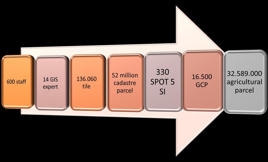

2 32,5 Million Agricultural Parcel

3 Land Integratıon


4 GIS Editing WEB-GIS Portal


5 Agricultural Production Registration Mobile Entry with GNSS Greenhouse Special products Good agriculture practices Organic farming Fisheries Apiculture Instant Monitoring Parcel Based Information Livestock Machinery Cooperatives, Unions Certified seed Veterinary Crop protection


6 YIELD MODEL Balıkesir Province Şanlıurfa Province where D max, y is Max yield value of the district, D min, y is the Min yield value of the district, C min, y.coef is the Min yield coefficient of the country, D max, y.coef is the Max yield coefficient of the district and x is the Yield coefficient of the parcel.

 Meteorological information Temperature Precipitation Evaporation Insolation etc.")
7 Land Information System Land Information System Parcel ID Owner and User information Land properites Depth Main material Structure Salinity Stone Drainage Distance to market Village center Farm center Traditions in Machinery usage Pesticide usage etc. Agricultural input Seed Medicine Chemical fertilizer Parcel base cost Topography Elevation Scope Aspect Land Use Types(crop field, permanent crop...) Meteorological information Temperature Precipitation Evaporation Insolation etc. Irrigation Parcel base yield Farm gate prices Parcel base and product base net income


 Invoice (e-fatura)")


8 Agricultural Information System Farmer Registration System, Agr.Prod.Information System, Producer Organizations Verification Owner information (Mernis) Legal person (Vedop) Invoice (e-fatura) Certification Land information Control ANALYSE Databases Satellite images (Product control in parcels) AIS Yield estimation in parcels INTEGRATION - Organic production information system - Good agricultural practices - Undershelter registration system - Land analysis information system - Fertilizer information system - Pesticide information system - Certified seed/nursery information system -Other SUBSIDIES - Crop production - Livestock production - Area based - Rural Development - Research and Development - Agri-environmental - Subsidy need - Land consolidation need - Energy need - Irrigation need - Desease forecast - Livestock potential - Optimal machinery REPORTING First entire integrated AGRICULTURAL INFORMATION SYSTEM in the World


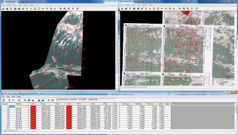
9 IACS Establishment-Spatial DB Air Photography Quality Control Digitization


10 IACS Establishment-Spatial DB 2147 GCP RMSExy <= 1.25 m


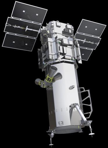
11 Image projection calculation using TR CORS data 146 NOTAM RESOLUTION 4 band RGB+NI 8 air planes GSD km 2 aerial imagery 30 cm km 2 satellite images 8 bit (256 levels)


12 IACS Establishment-Spatial DB aerial image processing


13 IACS-Quality ISO 2859 Controls on Delivery Rules Data Format Map Projection Coordinates Controls on Model Compliance Data Integrity (attributes) Geometry Topology Area Correspondence ISO Controls on Real Compliance Land Cover Class Photo Interpretation Sample

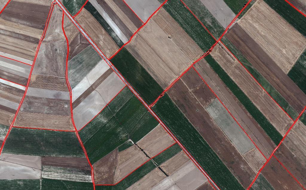
14 IACS Establishment-Land Cover Classification
15 IACS Structure Monitoring the subsidies CC Definition of SMR, GAECs FAS Other registers of special control institutions related to controls of CC CC Adminstration and checks SMR GAECs Computerised database Integrated Control System (ICS) IACS obligatory components In accordance with the Regulation (EC) No 640/2014 and Regulation (EC) No 809/2014 Aid Application System Administrative checks On-the-spot checks System for the calculation of aid, reductions and inclusions Eligibility Check Cross-comp. checks Eligibility Check Cross-comp. checks Direct Payments Other (AEM, LFA...) LPIS System System for Identification and registration of animals System for identification of farmers System for identification and registration of payment entitlements Avoiding misuse of national budget Analysing the effects of agricultural policies Determination of agricultural area Ensuring the agricultural sustainability Monitoring the land cover Avoiding misuse of land Supporting the producer Food Security Protecting environment


16 AIS-Agricultural Inventory 7/24 Monitoring INSTANT VERIFICATION MERNİS TAKBİS VEDOP


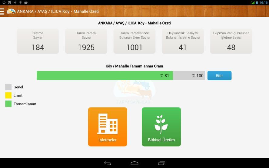


17 AIS-Agricultural Inventory Farm information Holding size Livestock and machinery asset Labour Irrigation system Land type Land disposal Sharecropping GIS editing Crop pattern Natural dissease information staff Parcel base LAND INTEGRATED


18 AIS-Agro-meteorological stations Instant Central Monitoring 1200 Stations sensors (4Mp 10x HD IP camera and UV-NIR Spektrometre) 2.2 billion measure More than 230 parameters in 12 million point


19 AIS-Agro-meteorological stations Pressure Internal/External Temperature Internal/External Humidity Wind speed Perfect data collection system Yield monitoring and forecast system Early warning system Leaf temperature/wetness Crop surface temperature Media System 2cm-5cm-10cm-15cm-45cm soil temperature/humidity Meteorological forecast system Precipitation amount/speed Radiation Spectral distribution


20 AIS-Agro-meteorological stations Field Archieve System


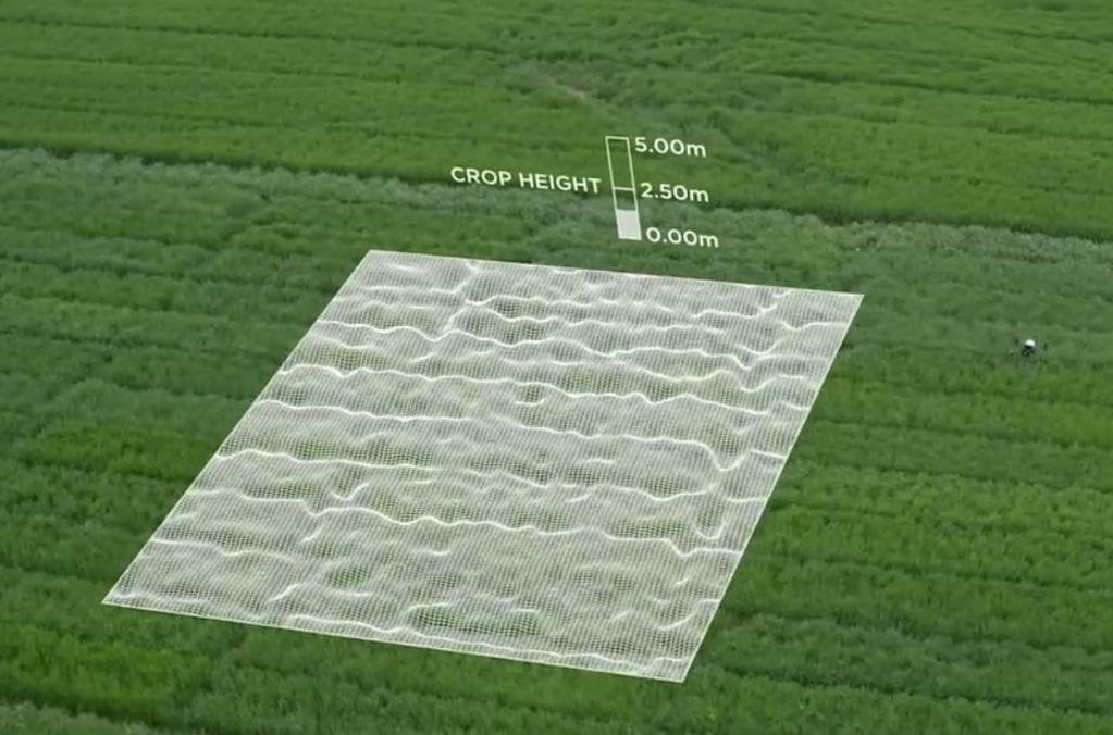
21 AIS-Agro-meteorological stations Phenelogical Monitoring System Height=4m-pix*k


22 AIS-Agro-meteorological stations Irrigation Monitoring System TARBİL Zirai Meteorolojik Tarım Gözlem İstasyonları Irrigation need Precipitation 7 km 2 for 1 Station Soil humidity Temperature

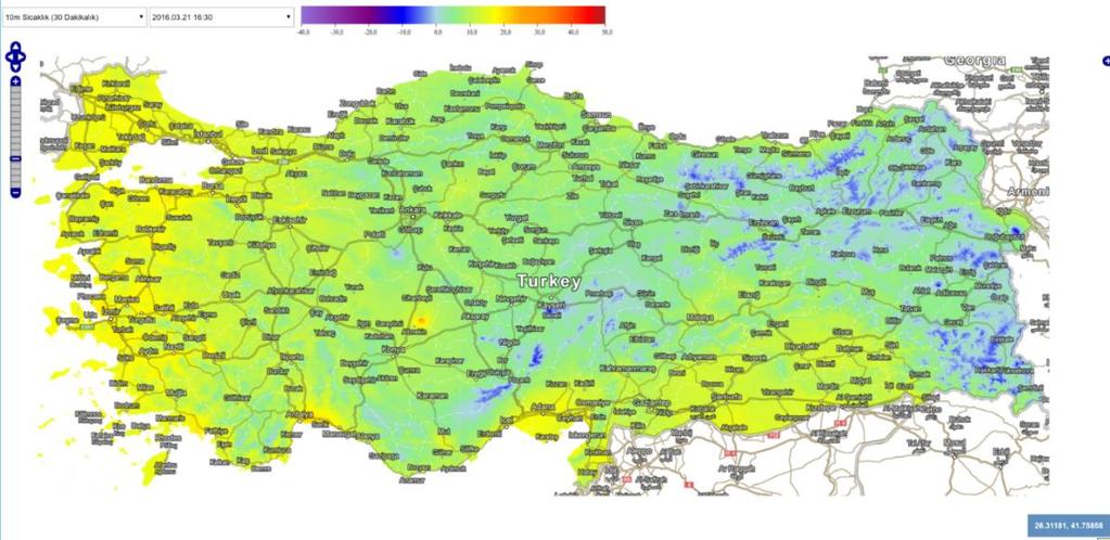

23 AIS-Agro-meteorological stations 12 million Virtual Stations 250 m 2


24 FARM ACCOUNTANCY DATA NETWORK With the integration of GIS map, the distance of the farms to the nearest water resources, city center, logistic facilities can be measured. Therefore, farm level spatial data can be used for irrigation planning and value chain analysis.
25 Thank you for your attention Dr.Hakan ERDEN Murat ASLAN