Asia-RiCE 2016 Implementation Report
|
|
|
- Godfrey Hodges
- 5 years ago
- Views:
Transcription
1 Asia-RiCE 2016 Implementation Report
 initiative.")

 outputs that have been enabled by the initiative.")

2 Asia-RiCE has been organised to develop the rice crop estimation and monitoring component for the GEO Global Agricultural Monitoring (GEOGLAM) initiative. GEOGLAM aims to enhance agricultural production estimates through the use of Earth observations, and Asia-RiCE seeks to ensure that the observational requirements for Asian rice crop monitoring are reflected in the GEOGLAM priorities. This report summarises the activities and achievements of Asia-RiCE in 2016 by providing examples of Technical Demonstration Site (TDS) outputs that have been enabled by the initiative. This document also aims to acknowledge and highlight the impact of contributions from data providers, and the role of the Asia-RiCE initiative in facilitating these inputs. Compiled by: Edited by: Matthew Steventon (Symbios Communications) Matthew Steventon, Stephen Ward, George Dyke (Symbios Communications); Shinichi Sobue, Kei Oyoshi (JAXA) Copyright 2017; JAXA, Symbios Communications
3 Table of Contents Introduction 1 Key Achievements 3 Technical Demonstration Site Achievements 5 Indonesia 5 Vietnam 7 Cambodia 9 Myanmar 11 Japan 13 Conclusion 15
4 Introduction Background and Scope The Asia-RiCE initiative has been organised to develop the Asian Rice Crop Estimation and Monitoring (Asia-RiCE) component for the GEO Global Agricultural Monitoring (GEOGLAM) initiative. GEOGLAM aims to enhance agricultural production estimates through the use of Earth observations, and Asia-RiCE seeks to ensure that the observational requirements for Asian rice crop monitoring are reflected in the GEOGLAM priorities. The goal of Asia-RiCE is to foster the widespread use of EO for wall-to-wall, whole country, timely and accurate forecasts of rice production at national, regional, and global scales, as an input to the GEOGLAM Crop Monitor and AMIS Market Monitor. Asia-RiCE is leveraging existing agricultural monitoring programs and initiatives at local levels (which serve as the Asia-RiCE Technical Demonstration Sites (TDS)) to develop, exercise and refine processes from stakeholder engagement, through resource marshalling and deployment, and on to trial implementation and product generation using SAR (i.e., radar) and other Earth observation data for rice crop monitoring. To achieve the overall goal of timely and accurate forecasts of rice production, TDS sites will need to develop and refine the generation of a number of key products, including rice crop area and yield estimations. These target crop and agricultural products are summarised in Table 1. It is expected that these products will be generated with national resources as input to crop forecasting systems. Product P1: Rice Crop Area Estimates/ Maps P2: Crop Calendars/Crop Growth Status P3: Crop Damage Assessment P4: Agro- Meteorological Information Products P5: Yield Estimation And Forecasting Table 1 Target Products for Asia-RiCE Description Cultivated area (every year). Inventory of agricultural facilities. Timing of sowing, planting, growing and harvesting/growing status. Identification of growth stages. Planted area progress (every month) per season. Crop growth anomaly. Detection of flooding and other disaster impacted area. Detection of drought or inundated area. Detection of diseased plants, pests and diseased infestation. Early warning. Anomaly detection (drought, extreme temperatures). Crop growth anomaly. Empirical-statistical model estimate. Crop-growth simulation model estimates. 01 Introduction
5 Phase 1 ( ) The activities of Asia-RiCE have been arranged into phases. Phase 1A ( ) consisted of four TDS in three countries: Indonesia, Thailand and Vietnam). Each of these was focused on the development of provincial-level rice crop area estimations. Note: Phase 1A only covers rice area statistics, maps, and yield estimates. The other products will be covered in Phase 1B/2. In Phase 1B ( ), additional technical demonstration sites in Chinese Taipei, Japan, and Malaysia were added. Scope This report will summarise the activities and achievements of Asia-RiCE to date by providing examples of TDS outputs that have been enabled by the initiative. This document also aims to acknowledge and highlight the impact of the substantial contributions from CEOS space agencies and the role of the Asia-RiCE initiative in facilitating these inputs. Phase 2 (2016+) Following the successful demonstration of the core functionality of Asia-RiCE, the initiative has moved into Phase 2, which increases the scope to whole country (or major crop area) estimates (with an initial focus on Thailand and Indonesia) to support the operational use of rice crop production information. 02 Introduction
6 Key Achievements Asia-RiCE works to connect in-country agricultural agencies, space agencies, and global agricultural initiatives. It s activities are therefore broad, but can be broken down into three major categories: data coordination, software/tool development, and reporting. Data Coordination The Committee on Earth Observation Satellites (CEOS) and its agencies are critical partners for Asia-RiCE. Asia-RiCE works with these space agencies to secure the data required by TDS teams for development of the target products outlined in Table 1 as well as other research activities. A key feature of the coverage being provided by CEOS agencies is the multiple band SAR (C/L/X), which facilitates important intercomparison studies. INAHOR estimates rice crop acreage and production using space-based Synthetic Aperture Radar (SAR) from the ALOS series, RADARSAT-2 and Sentinel-1. JASMIN provides satellite derived agrometeorological information including precipitation, drought index, soil moisture, solar radiation, land surface temperature, and vegetation index. The tool is able to generate two types of product for each parameter current condition, and anomaly, which is the deviation from past year s averages. JASMIN can generate either a map of the whole country or time series graphs at a number of predefined locations. The outputs assist the ASEAN Food Security Information System (AFSIS) and target country agricultural statistics experts in preparing AMIS outlooks for Asia-RiCE. Software/Tools JAXA/RESTEC continued development of the INAHOR (INternational Asian Harvest monitoring system for Rice; crop planted area estimation software) and JASMIN (agro-met information provision system for outlook) tools. 03 Key Achievements
7 Reporting Asia-RiCE continued its work with the ASEAN Food Security Information System (AFSIS) to provide crop condition overview information and outlooks to the GEOGLAM Crop Monitor for AMIS. The following sections, separated by country, highlight some of the major results achieved. 04 Key Achievements
8 Indonesia The National Institute of Aeronautics and Space of Indonesia (LAPAN) are the technical implementer and optical data provider of this TDS. LAPAN are also receiving and disseminating RADARSAT-2 data to the Indonesian teams that make up the TDS. The Indonesian Center for Agricultural Land Resources Research and Development (ICALRD), Indonesian Agency of Agricultural Research and Development (IAARD), and the Ministry of Agriculture (MoA) of the Republic of Indonesia support the production of information including paddy planted area and harvested area for the National Bureau of Statistics of Indonesia (BPS). Bogor Agricultural Institute (IPB) is acting as a technical supporter and field statistical data is provided by Badan Pusat Statistik (BPS, the National Bureau of Statistics of Indonesia, subdirectorate of food crops). In 2016, the Indonesian rice crop monitoring initiative was expanded to cover the top 10 high priority rice crop areas (in part because the East-West extent of the country means a larger number of satellite passes would be required to cover all areas). ICALRD are working with ALOS PALSAR data (provided by JAXA) for paddy growth stage analysis. Conclusions 1. ALOS PALSAR data has the potential for paddy crop monitoring in the central paddy areas. 2. Since the temporal resolution is 42 days, some growing stage classifications will be missed. 3. HH polarization has a higher backscatter value in each stage of paddy growth compared to HV polarization. 4. Next steps: Continue to analyze PALSAR data for Sulawesi. Process PALSAR-2 using the new version of the INAHOR software and compare the results. Some results are presented in the following figures. 05 Indonesia

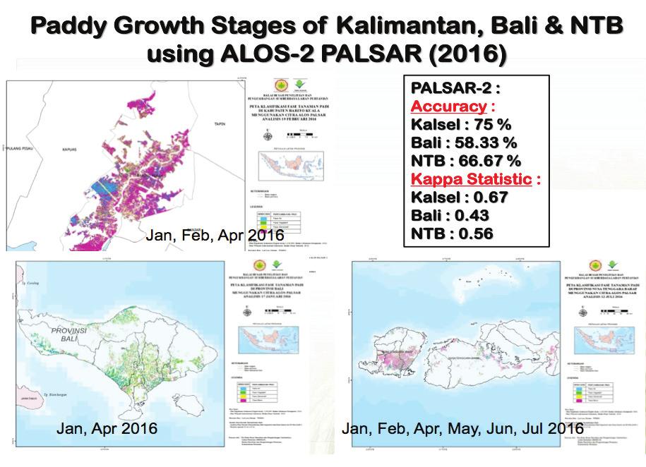
9 06 Indonesia
10 Vietnam The Vietnamese study region is located in An Giang province, and a selection of sampling sites are used in order to capture the diversity in rice cropping systems (two or three crops per year) and different cultural practices. For each site, measurements are performed on several fields. Ho Chi Minh City Institute of Resources Geography (HCMIRG), Vietnam Southern Satellite Technology Application Center (STAC-VNSC), and Vietnam Academy of Science and Technology (VAST) perform surveying, process and analyse data, and develop tools and models. Centre d Etudes Spatiales de la BIOsphère (CESBIO), France, provides technical advice on satellite data processing and field surveys. Next steps 1. Extend the target area and increase the observation frequency; 2. Increase validation activities for rice crop estimations; 3. Capacity building activities for end users; 4. Collaboration with other SAFE Prototype activities; Some results are presented in the following figures. The team aims to evaluate the use of SAR data in rice mapping and yield estimation, towards an operational system for a rice crop inventory in the Mekong Delta, Vietnam. The Vietnamese team has led the way in the application of newly available Sentinel-1A data for rice monitoring. Facilitated by the numerous SAR datasets provided by CEOS agencies over a number of years, a substantial amount of work has been done to compare results derived using various SAR bands (C/L/X). 07 Vietnam
 Data set: ALOS-2, 2016 31 SA 2016")
 SA")
")
11 Data set: Sentinel-1, 2016 SA 2016 crop (using ALOS-2 images) Data set: ALOS-2, SA 2016 crop (using S-1 images) A distribution map of estimated rice yield in SA 2016 crop (ALOS-2) SA 2016 crop (using R-2 images) A distribution map of estimated rice yield in SA 2016 crop (RADARSAT-2) Vietnam
12 Cambodia One of the newest members of the Asia-RiCE team, Cambodia, through the Department of Planning and Statistics, MAFF, is working to promote rice planted area and production estimation using space-based technologies. Until now, paddy area and yield related information has been collected through typical data collection methods involving local level surveys. The aim is to develop a new information collecting method that will be cost-effective and complementary to present rice crop area and production estimations, to support statistical information generation. Cambodia has undertaken training with the Japanese INAHOR SAR data processing system, which estimates rice planted area and production. The software allows local officers to easily produce useful information from satellite data in just 5 steps, using a graphical user interface. Results were validated with field surveys: Error was 4.4% compared with official statistics at the provincial level. Error was about 20% compared to official statistics at the district level. Some results are presented in the following figures. 09 Cambodia

 10")
13 INAHOR (INternational Asian Harvest monitoring system for Rice; crop planted area estimation software) 10 Cambodia
14 Myanmar Myanmar is another newcomer to the Asia-RiCE team. The Ministry of Agriculture, Livestock and Irrigation Department of Agricultural Land Management and Statistics aims to develop a system that uses innovative space based technologies for rice crop area mapping and yield monitoring. The objectives are: 1. To support the production of information on rice area, rice growth stages, and rice yield; 2. To advance the system of rice crop area mapping and yield monitoring using SAR data; 3. To substitute the existing agricultural statistical system with modern spacebased technologies. The team from Myanmar also used the Japanese INAHOR software and ALOS-2 data to estimate planted area and yield. Results were verified using 14 sample plots (200m 2 ) in the target area (Lewe township, Nay Pyi Taw). INAHOR with ALOS-2 derived statistics produced results in close agreement with official statistics. However, overestimation and underestimation of certain areas was found (overall 1.4% overestimation of planted area by INAHOR deemed to be acceptable). Evaluation of the resulting maps: Overall accuracy is good. Mis-classification areas were found in water body areas, dams and urban areas. There were small mis-classification areas, and more detailed validation is needed. How will the results be used in practical/ operational work? Checking the kwin-level information (planted area, etc.) collected by field survey/questionnaire. Utilizing the resulting maps for agricultural statistical data collection to conduct field surveys more efficiently and effectively. The resulting maps can be referred to for rice planted area and planning for particular purposes. Supporting the information of rice planted areas, planting times, and growth stages within short periods. Results are presented in the following figure. 11 Myanmar

15 Estimated Planting Date : 03/07/2016 : 31/07/2016 : 11/09/ Myanmar
.")
16 Japan The Japanese TDS team (Tsuruoka City, Yamagata Prefecture) is focused on research using multiple SAR datasets. A fleet of multi-frequency SAR missions is available (RADARSAT-2, RISAT-1, ALOS-2, Sentinel-1A/1B, TerraSAR-X, etc.). Multiple-SAR data can: Enhance data acquisition reliability; Improve data acquisition interval; Identify different physical characteristics of rice crops, e.g.: C-band (VV, VH; high sensitivity in planting phase); L-band (HH; high sensitivity in vegetative/reproductive phase); From 2015, Japan has been supplying ALOS-2 data to Asia-RiCE members under the Kyoto & Carbon (K&C) framework. JAXA/RESTEC also provide the INAHOR (INternational Asian Harvest monitoring system for Rice, crop planted area estimation software) and JASMIN (agro-met information provision system for outlook) tools to assist the ASEAN Food Security Information System (AFSIS) and target country agricultural statistics experts in preparing AMIS outlooks for Asia- RiCE. Integrated use of ALOS-2 + Sentinel-1 + RADARSAT-2 can yield SAR data every 4.6 days on average. 13 Japan


17 Near-real time Agro-meteorological Monitor provides satellite-based precipitation, drought index, solar! JASMIN Rice paddy monitoring in Tsuruoka province using multiple SAR data. Field data is collected using automated data collection stations. radiation, land surface temperature, soil moisture, and vegetation index.! These data are updated twice a month and utilized for the assessment of rice growth in GEOGLAM/Asia-RiCE activity. Top Page Image Time-series plot Target Areas were expanded to whole Southeast, South, and East Asia. JASMIN (agro-met information provision system for outlook) ALOS-2 Data Distribution System 14 Japan X
18 Conclusion A Critical and Unique Space Agency Service Asia-RiCE has demonstrated the great utility of the initiative, with substantial amounts of CEOS data flowing from space agencies to incountry agricultural agencies and researchers an achievement that would not have been possible without the collective efforts of the group and its connections to GEOGLAM and CEOS. As a result of Asia-RiCE, improved rice production estimates are being generated at national, regional, and global scales valuable inputs to the GEOGLAM Crop Monitor and AMIS Market Monitor that would not otherwise be present. Asia-RiCE thanks all CEOS agencies for their unique and critical contributions. For further information on Asia-RiCE Phase 2, please see the Asia-RiCE Phase 2 Work Plan: Phase2_Work_Plan_v1.0.pdf 15 Conclusion
19 16 Conclusion
20