SEN4CAP Sentinels for Agriculture Monitoring
|
|
|
- Blake Cobb
- 5 years ago
- Views:
Transcription


1 SEN4CAP Sentinels for Agriculture Monitoring Bontemps S., Defourny P., Bajec K., Bellemans N., Joshi N., Kucera L., Mammone C., Milcinski G., L. Rossi, C. Sciarretta, F. Tutunaru, F. Volpe, M. Zavagli, B. Koetz ESA UNCLASSIFIED For Official Use


2 Sentinels Looking after Agriculture


3 Sentinel-2: key revisit and spatial resolution Majority of Europe >3 day revisit S2 10 meters L8 30 meters Sentinel-2 Landsat 8 S-2A & -2B (July-Sept 2017)


4 Sentinel-1: Dense time series for crop stages monitoring Majority of Europe >2 day revisit S-1A & -1B (July-Sept 2017)


5 Uptake of Copernicus within the CAP th of July: Modernizing and simplifying the Common Agricultural Policy
6 European Collaboration Technology meets Policy Commissioner Phil Hogan, DG-Agri (25 th of May, Press release): This new satellite technology will significantly reduce the number of field inspections, removing the climate of fear, which causes significant stress for farmers. It will also benefit public administrations, by reducing the costs of administering controls ESA UNCLASSIFIED and - For Official checks. Use It is thus a win-win for farmers and administrators.
7 DIRECTORATE-GENERAL FOR AGRICULTURE AND RURAL DEVELOPMENT DIRECTORATE GENERAL FOR INTERNAL MARKET, INDUSTRY, ENTREPRENEURSHIP AND SME'S Directorate D. Direct support Space policy, Copernicus and Defence Directors Commission européenne/europese Commissie, 1049 Bruxelles/Brussel, BELGIQUE/BELGIË - Tel Ref. Ares(2017) /01/2017 Sen4CAP: R&D for Common Agricultural Policy Sen4CAP Implementation: o o Responding to the request from DG-AGRI & DG-GROW Collaboration with DG-AGRI, DG-GROW, DG-JRC and national Paying Agencies Sen4CAP Objectives: Mr. Josef Aschbacher Director of Earth Observation Programmes European Space Agency Via Galileo Galilei Casella postale Frascati - Italy o Provide evidence how Sentinel derived information can support the modernization and simplification of the CAP in the post 2020 timeframe o Provide validated algorithms, products, workflows and best practices for agriculture monitoring relevant for the management of the CAP Subject: EUROPEAN COMMISSION Brussels, D3/BR/cj Ares(2016) Cooperation between the European Commission and the European Space Agency (ESA) on the follow-up of the CzechAgri study Dear Mr Aschbacher, Both ESA and the European Commission have an interest in promoting and supporting the development of Earth Observation (EO) use and related capacity in Agriculture. We have taken great interest in the results of the CzechAgri study that was jointly initiated in December 2015 by ESA, DG JRC and SZIF (Czech Paying Agency) and successfully implemented thanks to ESA funding and a technical steering involving DG AGRI. Following these promising results, it would be extremely useful to further explore in close cooperation with the European Commission the capabilities of the Copernicus Sentinels in view of the current works on the modernisation and simplification of the CAP and the opportunities of EO from space for supporting the Integrated Administration and Control System (IACS). As you may know, technical solutions to improve and to make the IACS more cost efficient are high on the political agenda. A promising way forward is offered by the important potential of Sentinel/Copernicus for administration and control purposes, i.e. in a broader perspective than the current on-thespot controls using remote sensing. Indeed, the ambition for the next programming period is greater, we also want the IACS to be a key tool in the delivery of enhanced environmental services and public goods. With this letter, we acknowledge and welcome ESA s readiness to continue this effort by conducting two or three follow-up pilot studies to the CzechAgri project in preparation of the CAP 2020 reform together with the main stakeholders (DG AGRI, DG GROW and DG JRC) and the national Paying Agencies.
8 Sen4CAP Expertise, Technology & Collaboration Paying Agencies & Farmers DG-Agri, JRC, DG-Grow EO Experts Cloud Technology (DIAS) Validated Performance National Demonstration CAP2020 Reform


9 Sen4CAP Pilot Countries EU Agricultural Landscape
10 Sen4CAP Time Planning & Status User Requirements Data Acquisition Design Engineering System Development Prototyping ( ) PR KO+8 1 st Evidence Review System Update Full Demonstration Close out Ongoing Promotional Activities


11 User Requirements and Engagement 1. Analysis existing recommendations coming from the CzechAgri pilot study and the different PA workshops from the last months 2. Design of a questionnaire dedicated to the PAs formally involved in the project + interview of these PAs 3. Organize a User Requirement Workshop in which the user requirements were discussed actively with all bodies involved Czech Agri Pilot Study Sen4CAP 1st User Workshop, July 2017, Brussels
12 User Requirements in terms of IACS use cases Use case Crop diversification Permanent grassland identification EFA Land lying fallow EFA Catch crops EFA Nitrogen fixing crops Land abandonment Interactive visualization Use Cases w/ Paying Agencies LPIS update Claimless system


13 Identify Sentinel-based markers for CAP Monitoring Crop type mapping Autumn barley Vegetation growing indicator Crop type information & vegetation growing indicators Sunflower Grassland mowing detection Agricultural practices monitoring Number of detected mowing events Physical markers to monitor EFA agricultural practices
14 Prototyping - Developing & Testing at EU level 2 national coverage (NLD + CyL) km² test sites In-situ data sets shared by Paying Agencies o LPIS/GSAA datasets, subsidy applications, physical inspections, CwRS Sampling heterogeneous EU agricultural landscape: o LPIS types: Cadastral (IT, ES), Physical Block (NL, LI, RO), Farmers Block (CZ) o Field sizes: Minimum: RO & IT 72-85% < 1ha, Maximum: CZ 66% > 1ha o Landscape & climate: wide geographical range Algorithm Development, Benchmarking & 1 st Validation


15 Monitoring of Agri. Practices for EFA compliancy Czech Republic Catch crops, based on S1&2 time series 5 markers tracing crop activities Harvest Visual check Catch crop Harvest Catch Crop period Winter Catch Crop Visual check
16 Monitoring of Agri. Practices for EFA compliancy Czech Republic Catch crops, based on S1&2 time series 5 markers tracing crop activities Output: (per parcel) Harvest detection Harvest week Catch crop detection Confidence level for compliancy Catch crop Harvest Catch Crop period


17 National dynamic crop mapping at field scale Full Resolution Visualization Online:

 95% of parcels")
18 Crop type mapping for crop diversification monitoring Netherlands Observed crop type (2017) 95% of parcels
 Confidence indicator of")

19 Crop type mapping for crop diversification monitoring Netherlands Observed crop type (2017) Confidence indicator of agreement (2017) High confidence in agreement Average confidence in agreement Weak confidence in agreement High confidence in disagreement

20 Crop type mapping for crop diversification monitoring Lithuania Crop type mapping for crop diversification monitoring - Lithuania 56,6 ha 4 crops Compliance indicator of agreement at parcel-level High confidence in agreement Average confidence in agreement Weak confidence in agreement High confidence in disagreement Compliant at holding-level Available information: Total area of arable land at the farm-level Number of crops at the farm-level Proportions of the main crops


21 Sentinel-based vegetation indicator as auxiliary data Czech Republic 4 indicators NDVI FAPAR Czech Republic Low confidence in agreement LAI fcover High confidence in agreement ID NKOP_DPB AREA CONF_IDX CT_DECL CT_PRED_1 CT_CONF_1 C_INDIC / Maize Winter rapeseed 0,56 Expert Additional Judgement info required / Winter Wheat Grassland 0,25 Expert Additional Judgement info required

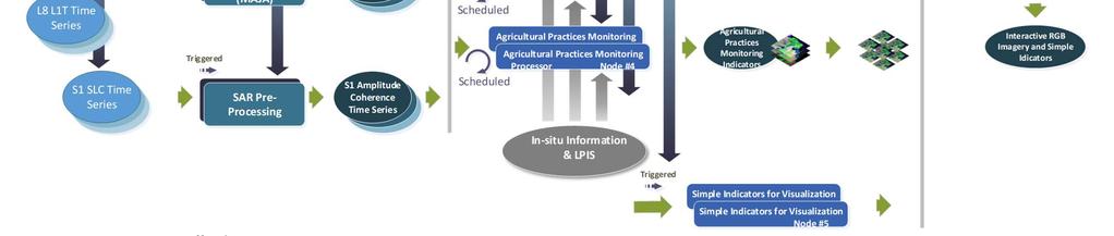
22 Design of Sen4CAP processing system


23 Towards PA s uptake in their environment Integration of S1 & S2 images, EO products & markers in PA s environment WMS providing RGB imagery and simple indicators o o o o o o o Easily integrated in PAs environment S1, S2 & L8 images Vegetation Indicators (NDVI, LAI, Fcover, FAPAR) Time filtering Configurable visualization Reprojection to local coordinate systems Customizable by country


24 Visualisation tool Implementation by country

25 Visualisation tool view attributes of the parcel related to the selected layer
26 Visualisation tool viewing results at farm level for compliance assessments


27 Visualisation tool Time animation following crop dynamics


28 Visualisation tool products metadata Product description Year Type of agricultural practice Regulation Interpretation of regulation Description of fields Legends Codelists with descriptions
29 From prototyping to national demonstration Prototypes for proof of concept 2016 & km² test site + national coverage (NLD and Castilla i Leòn) Full scale demonstration 2018 & 2019 National coverages for all six countries Near-real time processing (2019) and timely delivery Operational environment of pilot PAs Capacity building and training

30 Methodological developments Algorithms improvements and refinements based on PA s feedback o o o Crop type legend: are all the crop classes needed? How to merge? BPS vs crop diversification use cases Better understanding and integration of EFA regulations Better integration of S1 & S2 for grassland monitoring Selection of «monitorable» parcels o o Prototyping: 0.5 1ha threshold; inner buffers No more thresholds but considering only inner pixels Continuous monitoring
31 Continuous monitoring Romania Netherlands


32 EO data timely processing S1 and S2 data, since the 1st January 2018 continuously processed VV / VH ratio Bi-monthly statistics of VV backscattering: Coef Var / Mean / Coef Var Monthly average of VV coherence: April / March / February


")
33 2018 in situ data collection Subsidy applications for 2018 Farmers interview for grassland mowing and agri. practices o o Interactions by s 250 to 500 fields surveyed by practice (grassland, crop harvest, catch crops, nitrogen fixing crops, fallow land) On-The-Spot-Check (OTSC) data
34 National Monitoring - Processing resources Czech Republic Italy Input EO data ( ) 26 TB 128 TB Output L2 data ( ) 31 TB 137 TB Output L3 and L4 data ( ) 14 TB 50 TB Pre-processing resources (ongoing) 16 cores, 90 GB 48 cores, 230 GB Products & distribution resources (ongoing) *Average LPIS database volume: GB 28 cores, 72 GB 62 cores, 144 GB
35 Embracing DIAS Selection in progress to be ready end of 2018 for NRT processing in 2019 Sen4CAP requirements definition RFI document to the 5 DIAS-es Test access
36 Summary Sentinels benefits for CAP monitoring demonstrated with prototype products For IACS use cases: crop diversification, permanent grassland and EFA Under specific assumptions in terms of parcels size, parcels geometry, etc. Several ways identified to increase relevance of Sentinels markers Moving to national demonstration, wall-to-wall coverage, timely delivery Wall-to-wall coverage over 6 countries (1.2 Mkm²) with diverse cropping systems, LPIS, landscape, etc processing ongoing: in-situ and EO data (S1 + S2 pre-processing, markers) Tacking national-scale methodological issues Going to use cases Moving to DIAS Capacity building & training