USDA Use of Small Unmanned Aircraft Systems (suas)
|
|
|
- Sophia Anderson
- 5 years ago
- Views:
Transcription


 E.")


1 USDA Use of Small Unmanned Aircraft Systems (suas) E. Raymond Hunt, Jr. USDA-ARS Hydrology and Remote Sensing Lab. Beltsville Agricultural Research Center Beltsville, Maryland
2 Cultivation of soil, applications of fertilizers and pesticides, and crop breeding have contributed to record yields in the United States. Globally, areas suitable for agriculture are already under cultivation. The increasing human population will require more food grown on less land.


3 However, increases in agricultural production often result in increased soil erosion and poor water quality from nutrient and pesticide runoff. Both farmers and the environment benefit from increased agricultural efficiencies.
4 Precision farming is a set of technologies to manage agricultural inputs based on the variation of growth within a field. Key technologies are Global Positioning Systems (GPS) and Geographic Information Systems (GIS) Variation in plant growth in a field is based on soil properties: slope, aspect, texture, organic matter, water holding capacity, and so forth.


5 Precision Farming: Variable Rate Application Fertilizers and pesticides cost money Apply different amounts of fertilizer based on GPS Change rate of fertilization based on plant requirements How to determine plant requirements?


6 Precision Farming: Yield Monitors Yield monitors map fields from low- to high-yielding areas. High yielding areas require more fertilizer. Yield potential in fields is relatively stable from year to year. Depending on crop and weather, yields explain 50-75% of variance in fertilizer requirements.

 are used for N")

7 There are other technologies to help farmers manage nitrogen fertilizers On-the-go proximal sensors (GreenSeeker and CropCircle) are used for N management. Plants illuminated by LEDs, measure NDVI, Yellow-NDVI, or Green-NDVI, even at night.


.")


8 Most growers of high-end crops already use aerial photographs for monitoring (about /acre). UAS service providers need to provide better information at comparable cost.


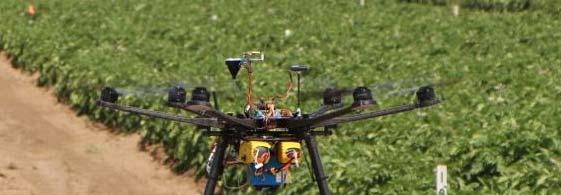

9 Conducting collaborative research at the Hermiston Agricultural Research and Extension Center, Oregon State University
10 After image acquisition, small scenes are mosaiced to get one large image. Is this necessary when managing a single field?
11 For nitrogen management, transects across field may be easier for input into GIS
12 Precision management of pesticides for controlling Colorado Potato Beetles


13 June 23, 2014 June 24, 2014 Insect damage occurred over a single day


14 In Japan, UAS are used to apply fertilizers and pesticides. Rice fields are small and muddy so tractors are not appropriate. Aerial application may not be feasible for production agriculture in the USA, because of large field sizes.
15 A Low-Volume Spray System on an UAV Helicopter


16 UAV Aerial Application for Large Crop Fields??? UAVs with 5-30 liter liquid tank capacity with spray rate 1-2 L/ha but AirTractor with 400 gal (1,500 liters) tank capacity with spray rate 5 gal/acre (47 L/ha); That means that UAVs have to reload 50 times to match up the manned aircraft s aerial coverage.


17 USDA-ARS Crop Production Systems Research Unit Stoneville, Mississippi Combining remote sensing with aerial application could be very important: t Precision spraying (reduced amount of pesticides) Rough terrain (invasive plants)


18 Clay Non - Irrigated Sandy Irrigation System Irrigated Management (Thomson and Huang)
19 UAS has been studied by the US Forest Service for >20 years Smoke blocks visible light. Fire hot spots are easily seen through h smoke using thermal infrared cameras


20 Placer River Trail Bridge (Alaska) Inspection Using Small Unmanned Aircraft Systems Mark Riley, U.S. Forest Service Rod Dell Andrea Andrea, U.S. Forest Service Everett Hinkley, U.S. Forest Service Bob Goetz, U.S. Forest Service David Lattanzi, George Mason University it Ali Khaloo, George Mason University Keith Cunningham, University of Alaska Fairbanks
21


22
23 Las Cruces, New Mexico Invasive species Rangeland degradationd Soil erosion Wildlife habitat


24 Information management at USDA Using suas for remote sensing: Small pixel size Rapid turnaround of information to user Low cost However, information from suas is highly context specific Wildfire, Insects, N requirements USDA has many other responsibilities that t need long term archives: Identify individual species and wildlife habitat Inspecting structures Thanks to the many people in USDA who contributed to this Thanks to the many people in USDA who contributed to this talk.