WILDLIFE, AGRICULTURE, SCENIC OPEN SPACE, PUBLIC RECREATION
|
|
|
- Alexia Reynolds
- 5 years ago
- Views:
Transcription
1 SECTION I: CONSERVATION EASEMENT MONITORING VISIT BACKGROUND Background Property Name Silt River Preserve Conserved Acres 132 Year(s) Conserved 2010 Conservation Values Current Owner Primary Property Contact Primary Property Contact Present During Visit Contact Notes Monitor Name Monitoring Method WILDLIFE, AGRICULTURE, SCENIC OPEN SPACE, PUBLIC RECREATION Town of Silt Trey Fonner, Public Works Director PO Box 70 Silt, CO ext 106 Toured property with Trey Fonner (Town of Silt) and Nate Higginson (Middle Colorado Watershed Council) David Erickson Ground Date of Visit Description of Ground Monitoring Method Walked ranch road to ponds then walked NW to western boundary Walked east through northern portion along the river and back to parking lot via ranch road SECTION II: BUILDING AND IMPROVEMENT UPDATES ROADS Road Update Road Description The Town of Silt put a temporary road through the riparian zone in order to build a new foot bridge They did this in the winter of 2018 with the blade of a small backhoe They plan to allow this to re-vegetate
2 SECTION II: BUILDING AND IMPROVEMENT UPDATES TRAILS Trail Update Roaring Fork Outdoor Volunteers (RFOV) organized a trail build day on May 5th that was attended by over 30 volunteers RFOV also managed a crew of 10 from Rocky Mountain Youth Corps (sponsored by Garfield County ) who spent 4 days building trail in mid-june In total, a ~08 mile loop through the riparian zone was almost completed The western most section of this loop is the last piece to finish Trail Description The new trail was quickly overgrown with weeds, especially knapweed The hope is that the remaining segment can be completed soon and trail signs used -- including something at the parking area -- to guide users In addition, Town of Silt staff built a foot bridge across the small channel separating the agricultural area from the riparian area Silt plans for this bridge to serve as a future connection to trails into the remainder of the property that were contemplated when the town acquired the property IRRIGATION INFRASTRUCTURE Irrigation Infrastructure Update Irrigation Infrastructure Description Irrigation infrastructure on 102 acres of pasture in the SW portion of the property was updated this year with the help of a Colorado River District grant and the annual Gerry Pace grant This includes three new sprinkler gun connections, a 920' side roll, associated pump, power connection and waterlines By next year, over 32 acres of pasture on the property will be irrigated with sprinklers Trey hopes to reuse the gated pipe that formally flood irrigated these SW pastures to bring irrigation back to the area between the ponds and the riparian zone UTILITIES Utility Update
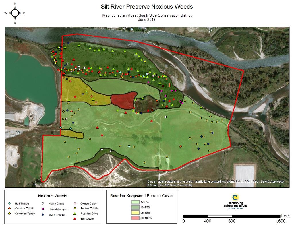
3 SECTION II: BUILDING AND IMPROVEMENT UPDATES Utility Description Holy Cross electric is going to add two new power poles to bring electricity to a new irrigation pump that will service the improvements underway in the SW portion of the property SECTION III: RESOURCE MANAGEMENT AND USE OF PROPERTY AGRICULTURE Property Used For Agriculture Type(s) of Agricultural Activity Description of Agricultural Use of Property Livestock Property is currently leased to Wayne Pollard, a local rancher, for cattle grazing (winter through spring) WATER RIGHTS Water Rights Associated with Property How are Water Rights Used on Property To irrigate the pastures and 1-acre community garden plot RECREATION Recreation Use of Property Description of Recreation Use Public use of the property for walking and fishing WEEDS Noxious Weeds Observed or Reported Noxious Weed Species Observed or Reported Bull thistle (Cirsium vulgare), Canada thistle (Cirsium arvense), Common Tansy (Tanacetum vulgare), Hoary cress/whitetop (Cardaria draba), Houndstongue (Cynoglossum officinale), Musk thistle (Carduus nutans), Oxeye daisy (Chrysanthemum leucanthemum), Russian knapweed (Acroptilon repens), Russian olive (Elaeagnus angustifolia), Salt cedar/tamarisk (Tamarix spp), Scotch thistle (Onopordum acanthium)

4 SECTION III: RESOURCE MANAGEMENT AND USE OF PROPERTY Description of Noxious Weed Issue(s) Are Weeds Treated on Property Description of Treatment Weed Management Suggestions Due to drought conditions and soil disturbance, weeds were pervasive, especially in the northern portion of the property A technician from the South Side Conservation District inventoried the property and created a map of weed locations that is attached to this report Numerous weed species were noted with Russian Knapweed being the most dominant species Unknown The town of Silt, with financial assistance from Garfield County, was trying to get a fall spray of knapweed and thistle Need a multi-year weed management plan NATURAL HISTORY OBSERVATION(S) Natural History Observation(s) Description of Natural History Observation(s) Saw deer and turkeys during the monitoring visit Also, the mating pair of Bald Eagles nested on the island and fledged two young this year SECTION IV: MONITORING PHOTOS Photo Point - 1 Property overview from mound between ponds ( , ) View W


5 View N View E View S Photo Point - 2 New footbridge across channel ( , )


6 Photo Point - 3 Rock lined entrance/exit to new trail built by volunteers and the youth corps this year ( , ) Photo Point - 4 Portion of new volunteer built trail that was covered in weeds ( , ) Photo Point - 5 Looking along a portion of trail built this year ( , ) View E


7 Photo Point - 6 Looking through the riparian zone ( , ) View E View W Photo Point - 7 Trail along river worked on by the youth corps ( , ) View W


8 Photo Point - 8 Overview of eastern most pasture ( , ) View E View NE Photo Point - 9 Overview of historic barn structure ( , )


9 Photo Point - 10 Overview of western portion of property ( , ) View W towards boundary and where new sprinkler connections and side roll are being installed View NW View S along community garden plot SIGNATURES Note: This report is a record of conditions observed on the property (or part of the property) at the time of monitoring The absence in this report of any record of observed prohibited uses or other violations that may have occurred on the property prior to the monitoring visit does not waive the Trust s right to enforce against any such violations at a later date Should the Trust detect a prohibited use or violation in the future, the Trust may still exercise its rights to enforce the conservation easement David Erickson Stewardship Director

10 SILT RIVER PRESERVE Property boundary depicted is an approximate representation and no substitute for a survey 2018 Ground Monitoring Photo Point Map LEGEND PROPERTY BOUNDARY # 2018 MONITORING PHOTO POINT ,000 Feet BASEMAP: USDA NAIP 2017 µ
11