FROM TRADITIONAL TO MODERN PRACTICE
|
|
|
- Marilynn Randall
- 5 years ago
- Views:
Transcription


 Michael Okwalinga (ADK09022) Maja")
1 FROM TRADITIONAL TO MODERN PRACTICE LIVELIHOOD STRATEGIES OF THE VILLAGERS OF KAMPUNG PUEH INTERDISCIPLINARY LAND USE AND NATURAL RESOURCE MANAGEMENT Supervisors: Dr. Michael Eilenberg & Mr. Myles Oelofse Date: Number of words: Marie Louise Dahl Gydesen (ADK09011) Lis Hølzer (EM10089) Valentina Mandirola (EMS0920) Michael Okwalinga (ADK09022) Maja Lund Rasmussen (EM10012)
2 ABSTRACT The present study was conducted in Kampung Pueh, Sarawak, Malaysia. We found that many aspects of village life appeared to be connected to change in livelihood. Hence, we aimed at assessing the livelihood strategies of the Pueh community in relation to the shift from traditional to modern practice. To achieve our objective, a range of methods such as questionnaire, interviews, PRA tools and environmental sampling were applied. The main food generating activities are cultivating home gardens, fruit orchards, paddy rice and livestock rearing. Income generating activities are sale of cash crops, paddy rice and fruits. Even though most villagers farm they are not solely dependent on this. More people are engaged in waged labour and have found additional ways to make a living e.g. many lease land to the oil palm plantation and some are involved in the Tourist Homestay Program. Moreover, there is a strong migration trend that may eventually affect village life. Change in land use has affected the biodiversity of both plants and animals with environmental challenges as a result. As more land has been converted to oil palm plantation internal concerns regarding land rights seem to have become more prominent. The access to the forest has been restricted as the area is now a forest reserve. This reserve appears to have caused major changes in regards to wild life and timber availability. The villagers attitudes towards the forest have changed they no longer slash and burn, as they are restricted from this practice. i
3 ABBREVIATIONS COD BOD DO DOA FAO FCC GPS HAOS HSP K N NCL P PRA RM SALCRA TSS UNIMAS Chemical Oxygen Demand Biochemical Oxygen Demand Dissolved Oxygen Department of Agriculture Food and Agricultural Organization Faecal Coli-form Global Positioning System Homestay Association of Sarawak Homestay Program Potassium Nitrogen Native Customary Land Phosphorous Participatory Rural Appraisal Ringgit Malaysia Sarawak Land Consolidation and Rehabilitation Authority Total Suspended Solids University Malaysia Sarawak ii
4 ACKNOWLEDGEMENTS We would like to thank: Our Malaysian counterparts: Miss Caroline Irene Aton Miss Christina Annette Jinam Supervisors from the University of Copenhagen: Dr. Michael Eilenberg Mr. Myles Oelofse Supervisors and experts from UNIMAS: Mr. Kelvin Dr. Lim Dr. Wong Dr. Bob (animal survey) Dr. Gabriel (Soil, vegetation) Dr. Lau (water) Villagers of Kampung Pueh: We would like to thank all the villagers of Kampung Pueh for helping us by participating in our research and giving us valuable insight in their lives. A special thanks goes to our translators: Mr. Eran, Miss Shirlyn and Miss Jenny, without whom the fieldwork would not have been possible. We would also like to give a special thanks to our host family, Idem anak Jisuk, for creating a cosy and pleasant environment to work in. iii
5 TABLE OF AUTHORSHIP Section and Title Main Author Contributing Author Abstract Marie Louise Dahl Gydesen Lis Hølzer Valentina Mandirola Michael Okwalinga Maja Lund Rasmussen Introduction Marie Louise Dahl Gydesen Lis Hølzer Valentina Mandirola Michael Okwalinga Maja Lund Rasmussen Methodology Marie Louise Dahl Gydesen Lis Hølzer Valentina Mandirola Michael Okwalinga Maja Lund Rasmussen Reflections on Methods and Field Approach Marie Louise Dahl Gydesen Lis Hølzer Valentina Mandirola Michael Okwalinga Maja Lund Rasmussen Research Question no. 1 Maja Lund Rasmussen Marie Louise Dahl Gydesen Lis Hølzer Valentina Mandirola Michael Okwalinga Research Question no. 2 Marie Louise Dahl Gydesen Lis Hølzer Valentina Mandirola Michael Okwalinga Maja Lund Rasmussen Research Question no. 3 Michael Okwalinga Marie Louise Dahl Gydesen Lis Hølzer Valentina Mandirola Maja Lund Rasmussen Research Question no. 4 Valentina Mandirola Marie Louise Dahl Gydesen Lis Hølzer Michael Okwanlinga Maja Lund Rasmussen Research Question no. 5 Lis Hølzer Marie Louise Dahl Gydesen Valentina Mandirola Michael Okwanlinga Maja Lund Rasmussen Conclusion Marie Louise Dahl Gydesen Lis Hølzer Valentina Mandirola Michael Okwalinga Maja Lund Rasmussen iv
6 INDEX ABSTRACT ABBREVIATIONS ACKNOWLEDGEMENTS TABLE OF AUTHORSHIP I II III IV INDEX V INTRODUCTION 1 Objective 2 Research Questions 2 METHODOLOGY 3 REFLECTIONS ON METHODS AND FIELD APPROACH 8 ACTIVITIES AND CHANGES IN KAMPUNG PUEH 12 ENVIRONMENTAL ISSUES RELATED TO LAND USE CHANGE IN KAMPUNG PUEH 18 SOCIAL IMPACTS OF CHANGING LAND USE 24 FOREST RESERVE AND KAMPUNG PUEH 29 TOURISM IN KAMPUNG PUEH 34 CONCLUSION 38 BIBLIOGRAPHY 40 APPENDIXES 42 Appendix A: Extensive Data on Methods 42 Appendix B: Improved Questionnaire 48 Appendix C: Village map from PRA Mapping Exercise 51 Appendix D: GPS Map 52 Appendix E: Statistics of Kampung Pueh 53 Appendix F: Map of SALCRA Area 55 Appendix G: Water Results 56 Appendix H: Preliminary Soil Results 58 Appendix I: Table of Animals 62 Appendix J: Drawing of Forest Areas 63 Appendix K: Picture of Samunsam Extension Area 64 Appendix L: Brochure of Kampung Pueh Homestay Program 65 Appendix M: Synopsis 67 v
7 INTRODUCTION Our fieldwork took place in Kampung Pueh, a village situated by the South China Sea at the foot of Gunung Pueh (Mount Pueh) in the federal state of Sarawak, Malaysia. The village was named after the grass growing in the area. The village consists of 864 inhabitants in total 828 of these are Bidayuh Salako 1. We were able to trace the history of Kampung Pueh back to At this time the villagers were settled near the river Sungai Angkabang. In 1879 the village suffered an outbreak of cholera and lost most of their inhabitants. This experience caused them to leave this location and move to the other side of the river. Once here the villagers split in two groups. The people who stayed by the river built a number of longhouses as the village grew bigger year after year these people founded Pueh. In 1939 the longhouse, that is currently housing 20 households in Pueh, was build and it is actually the only Bidayuh Salako longhouse in Sarawak. Most people in Pueh are involved in farming. They cultivate rice, traditional cash crops like pepper, oil palm, cocoa, coconut and rubber, furthermore most villagers engage in home gardening. 14 households are involved in the Homestay Program, which was endorsed by the Ministry of Urban Development and Tourism under Homestay Association of Sarawak. Some 171 villagers work as waged labourers 2. The Malaysian government policy aims at turning Malaysia into a developed country by Traditional land use is considered inefficient and is therefore disregarded 4. In order to reach their goal and become a developed country the government concentrate intensely on financial growth and on implementing oil palm plantations so far these plantations cover more than 40% of the total cultivated land in Malaysia and the government plans to double the area within the next three years 5. The implementation of government programs seems based on a top-down approach an approach that seem very distant from theoretical approaches regarding development. These theories put emphasis on applied, 1 Confer Appendix E 2 Confer Appendix E 3 Mohamad 1991:2 4 Cooke 2002: The international demand for palm oil makes this strategy an important economical investment as well. The government s development strategy also includes other programs and focus areas ( 1
8 action-oriented and participatory research thereby empowering the local people and directly involving them in the development work 6. While doing fieldwork in Kampung Pueh we found that there were many aspects of life in the village that seemed to be related to change traditional practices seemed to be slowly replaced by more modern ways of life. The access to the forest area has been restricted with the creation of a forest reserve in 1985, the villagers have experienced giving up land for the oil palm plantation in 2003 and they are now experiencing the impact of the tourist Homestay Program that was implemented in On top of this, migration seems to have become a major issue in Kampung Pueh, which may eventually bring further changes to the village. This report will start by introducing the objective of our study and our research questions followed by our methodology. We will then reflect on the methods used and on field approach. This section is followed by our analysis starting out by reviewing and discussing the findings on the activities that the villagers engage in, in order to sustain their livelihoods. Hereafter we will discuss the findings regarding land use change and the environment followed by the social aspects of changing land use. We will then discuss the findings regarding the forest reserve and finally we will discuss our findings on tourism in Kampung Pueh. Our work has been concentrated around the following keywords: change, livelihood and land use. OBJECTIVE We want to assess the livelihood strategies of the villagers of Kampung Pueh in relation to the shift from traditional to modern practices caused by both the villagers and external actors. RESEARCH QUESTIONS 1. What types of activities do the villagers engage in, in order to sustain their livelihoods? 2. How has change in land use affected agriculture and environment? 3. What are the social impacts of the change in land use due to the oil palm plantation? 4. Has the delineation of the forest reserve affected the community and in what way? 5. How has tourism affected the lives of the villagers? 6 Hill & Birch-Thomsen 2005:13 2
9 METHODOLOGY We used a number of both social and natural science methods to collect the required data while in the field. The information we collected is both qualitative and quantitative. By using more methods from different disciplines we hope to have reduced the risk of scientific bias and that we have been able to triangulate the collected data. The following section will provide an overview of the various methods used in the field 7. GPS MAPPING AND TRANSECT WALKS We carried out the first transect walk on the first day of the fieldwork and the purpose was to get an overview of the village and its surrounding area. We walked with our interpreter who was familiar with the village. We gathered information on the natural resources that are available, soil management practices, types of crops grown, water sources and management, tree species, livestock and infrastructures within the village. We also did three other transect walks in different directions and this enabled us to get a more comprehensive understanding of the village. While transecting the village a GPS was used in order to be able to make a real map of the village including location of the forest reserve, the oil palm plantation, the paddy rice fields, the beach, the mixed crops area and the orchards. This helped us know the actual land area of the village. Fig.1 Kampung Pueh Resource Map 8 7 For more elaborate data on the methods applied in the field, e.g. Dates, participants etc. confer Appendix A 8 To see the map in large size confer Appendix D 3


10 PRA METHODS The participatory field approach was very important during our fieldwork. None of us had tried these methods before and we wanted to make use of the ones relevant for our research. RANKING EXERCISE We used this method in order to understand the importance of both food and cash generating activities. We had prepared for this session by drawing a table on a big piece of paper. The predestined activities were written in both Malay and English. A bag of beans was provided as a means of indicating importance. The participants were encouraged to place the highest number of beans on the most important activities. They started out by ranking the food generating activities and finished with the cash generating activities. This method was a fun and easy way to gain knowledge and learn from the villagers by listening to their discussions. HISTORICAL TIMELINE We wanted to learn about village history and about the events that have influenced the villagers and their ways of life. We were able to trace history back to We learnt about past village locations, events and about changes that have occurred in recent years electricity, tourism, migration, individual housing, forest restrictions, oil palm plantation etc. This exercise was a great way to reach a broader understanding of Pueh and its inhabitants. Fig. 2 Historical timeline exercise 4
11 VILLAGE MAPPING We used this method the second day in the field in order to obtain a quick overview of the area, resources present, the crops grown, social issues and the general use of the area 9. From the exercise we learnt how the villagers perceive their community, current land use and which things they find important. SEASONAL CALENDAR The purpose of this exercise was to identify livelihood activities and the time of the year when these activities are performed. The method also helped us know more about when the households receive their various incomes and variations of income flow during the year. FOCUS GROUP We did three focus groups while in Pueh. We found this method very useful, as we would learn from the actual discussion while also being able to observe and possibly catch the important issues and underlying matters that were not being said directly. The data we collected from these sessions were also important as they could be triangulated with the results we had found during the introductory days in Kampung Pueh. A question guide was used to direct the discussion. FOCUS GROUP: YOUTH, FUTURE PROSPECTS The purpose of this exercise was to collect data on the young generations expectations of the future and of adulthood. Our preliminary investigations showed that there seemed to be a strong migration trend, so we wanted to gather more information on this topic as well. It was very interesting to explore their opinion on the main topics of our research. The exercise provided us with much relevant data to include in the analysis of the changes that affect the village now and in the future. FOCUS GROUP: OIL PALM PLANTATION (INCLUDING PAST ACTIVITIES) This method helped us create an understanding of the livelihoods of the villagers and the agricultural activities that took place before the implementation of the oil palm plantation and thereby also the socio-economic impact of it. We showed the participants a map of the SALCRA oil palm plantation with the boundaries of the different sections. We asked them to describe how this area was used in the past, who used to cultivate where 9 Brockinton & Sullivan 2003:61 5
12 and what did they cultivate. The aim was to find out more about their past activities in that area, the importance and the possible feeling of loss in relation to the oil palm plantation. FOCUS GROUP: FOREST AND NATURAL RESOURCES The discussion explored the contradictory topic of the forest reserve. We wanted to learn about past and present resources, in addition to former and present use. Most importantly we needed to learn what the villagers defined as forest reserve as this definition had puzzled us before the focus group discussion. We used a map which we had drawn beforehand to illustrate exactly what we meant when we talked about forest reserve. The map included the forest reserve, the wildlife sanctuary, the village and the agricultural areas. This tool was used to avoid any further confusion. The second tool used was two books describing and picturing mammals and birds of Borneo. This allowed the participants to look at the pictures and recognize the animals present in the surroundings of Kampung Pueh. We also used the opportunity to talk about natural resources, such as water. SEMI-STRUCTURED INTERVIEWS This method enabled us to collect detailed information about all of our research questions while being open and ready to explore issues that randomly occurred during an interview. The interviews were mostly conducted at the private houses of the informants. The informants were picked according to their involvement in or possible knowledge of activities and issues of our interest. We made use of interview guides in order to secure the structure and aim of the interviews. Our translators were present for most of our interviews i.e. sometimes interviews were carried out in English or with help from our Malaysian counterparts. QUESTIONNAIRE We made use of this method in order to collect quantitative data on all of our research questions. We conducted the survey as structured interview, where an interpreter translated the questions, we asked, as opposed a self-administered questionnaire. This was done in order to minimize the risk of misunderstandings and misinterpretations. A questionnaire often provides a fast overview of issues of interest however, it doesn t provide in-depth data. We aimed at triangulating the data collected using this method with the data collected using other methods. This provides a more solid picture of the issues that we have been studying. We pre-tested the questionnaire on our friends from the Kendai group before going to Malaysia. This helped ensure clarity, comprehensiveness acceptability, and exterminate ambiguity. The households were selected randomly by picking every third household from the list of all households in Kampung Pueh. 6
13 FOREST ASSESSMENT The actual forest evaluation was made through direct observations during the forest walk and thanks to the local guides we gained knowledge of species that the villagers use and of the main valuable tree species still present. This exercise was carried out in order to further understand what resources that are and used to be present in the forest area. The observations and discussions during the walk helped us understand how this area has undergone change. ANIMAL ASSESSMENT We set out traps in the plantation area, the orchards and in the mixed crop areas in order to further assess biodiversity. We also observed for spoor and habitat. These data were triangulated with data collected from other methods used on environmental issues. WATER SAMPLING Water quality data were collected based on in situ measurements and laboratory analyses. The water samples were collected from the mouth of the river, in a stream in the oil palm plantation and at the dam. They were recorded using the Hydrolab Multiprob, used to record the water temperature, dissolved oxygen, ph, electrical conductivity, turbidity and redox potential. Laboratory analyses were performed to determine the biochemical oxygen demand (BOD), chemical oxygen demand (COD - it was determined using the Merck Environmental Kit), nutrients (analyzed using the Hach Kit), colour, total suspended solids (TSS), heavy metals (analyzed using an Atomic Absorption Spectrometer) and microbial level (analyzed using the Paqualab System) of the water. We wanted to measure the quality of the water resources in Kampung Pueh. SOIL ANALYSIS Soil was collected from six locations: The oil palm plantation, paddy fields, home garden, pepper field, rambutan orchard and mango orchard. We used an auger to take out cores of soil; the first core reached 8 inches and the second reached 16 inches into the ground. We took two (or three) cores from each site. Physical parameters, such as texture and colour, were evaluated in situ. Samples from each site were dried and taken to a laboratory in order to assess soil organic matter, PH, conductivity and plant available nutrients like N, P and K. 7
14 REFLECTION ON METHODS AND FIELD APPROACH A continuous source of frustration and challenge throughout our fieldwork was one of our interpreters, Mr. Eran. We expected to use him as a translator, but we quickly realized that he only worked as an interpreter, meaning that it seemed like he interpreted everything we said and came up with his own ideas and solutions to what we wanted to do, e.g. when we wanted to do a PRA on village mapping, he decided that because the village already had a map, it was not necessary for us to do the exercise, and he thus neglected to invite people, as we had agreed on. On other occasions when we wanted to interview certain people and asked him to make the appointments, he would make appointments with other people without informing us of the change in plans, which lead to some very confusing interviews. Also, we quickly realized that when we interviewed people he often answered on behalf of the informants, and therefore we constantly had to remind him on his role as a translator. When doing PRAs he would often forget his role as a translator and instead work as the sole informant on the matters. When we reminded him on his role, he would become seemingly angry that he could not do the exercise himself. Perhaps we could have prevented some of the incidents with Mr. Eran by thoroughly explaining what we wanted and what we did not want him to do. We tried after the first incident, but apparently it was not sufficient. Another challenge was doing the questionnaire survey. We had selected people randomly from a list of village households, and had planned to carry out the survey during the day, but we had forgotten the fact that people work during daytime. This resulted in a very high proportion of elderly informants, as they were the only ones at home. The opportunity of studying in the field was a great experience and challenge for all of us. The heterogenic composition of the group, gave us a large spectrum of approaches and points of view that complemented each other during group discussions and the actual work in the field. The period spent in Kampung Pueh, although been brief, has been a full time learning experience. We learnt form everything around us and from the academic point of view through the application of the research methods. We acquired new knowledge with help from the villagers and the Malaysian teachers regarding specific topics. Concerning the everyday life in Kampung Pueh, everything we experienced about their culture and the approach with which we researched our predetermined topics made this fieldwork experience an excellent example of learning by doing. 8
15 What we could have done differently: Issue: Mistake: Effects: Sampling Due to time constraints, we only sampled 25% (30 households) of the villagers in the questionnaire we should have sampled 50% 10. Secondly, even though we selected our informants randomly from a list of households, the proportion of households living in the longhouse was too high (9/30 = 30 %) compared with the actual proportion (20/134 = 14,9 %) Thirdly, the age group of the questionnaire respondents was skew 43,3 % belonged in the 50+ category. Data are not fully representative for the village and might be skewed with regards to dwelling. The fact that almost 50 % of the questionnaire informants belonged to the high age group should not have an effect on our data, because they were asked to answer on behalf of the household. Ranking exercise We forgot to put livestock as an option. We neglected to leave room for additional categories, e.g. livestock. We had prepared two bags with 100 beans in each, but accidentally we used the leftovers, a bag of 285 beans. We did not achieve to get a complete overview of the village s food security and income generating activities. The high number of beans might have been hard for the participants to handle they became less careful on where they placed the beans, which might have biased the obtained data. Questionnaire Questions about the forest might have been easily misunderstood, as we found out that different people understood the concept forest differently. Forest could both mean forest reserve and forest sanctuary, so we should have specified which we The questionnaire results regarding the forest might not be correct, as we realized different meanings and understandings of the issue after we had completed 10 With population sizes less than people 50% of the population is representative. Rea & Parker
16 meant. Questions like assessing levels: high, medium, low, might have been a bit too abstract to put in a questionnaire. Some questions lacked the option: I don t know. the survey (perhaps we would have asked differently, if we had known what we know now). Questions regarding levels are also a bit ambiguous, and thus we have taken care not to put too much emphasis on these questions. Even though it was not an option to answer I don t know, some did anyway, and we wrote it down and considered it in our data analysis. Some respondents might have felt pressured to answer one of the given options, even if they were in doubt (this is biased data!). Informants Due to poor communication with our interpreter, we did not always manage to get the right informants for interviews, e.g. we wanted to interview someone who was no longer a part of the Homestay Program, and instead we got two women who were still part of it. We also wanted to interview tourists on their experience of the Homestay Program. Our results on tourism might be biased, as we only have information from people involved in the Homestay Program. Vegetation sampling We wanted to do vegetation sampling at different sites (forest, home gardens, and plantations) and had made arrangements for this, but unfortunately this appointment was disregarded without notice. This information could have given our question about environment further depth and validity. Focus groups The participants of the youth future prospect were very young. We would have liked to have participants in their late teens not their early teens in order to have a serious discussion. The results from the focus group with the youth are perhaps not the data we looked for, but despite their youth, they did have some 10
17 The focus group on oil palm plantation (including past activities) did not go as we planned, as our interpreter constantly tried to take charge and lead the discussion. We wanted to have homogenous groups, but in fact ended up with heterogeneous participants. interesting points of view. We ended up doing the focus group on oil palm without our interpreter (as he didn t seem to understand and agree on his role instead our Malaysian counterpart took charge of the discussion), why we might have missed out on some important facts, issues. The group composition might have affected the participants level of involvement. Animal traps We did not collect the traps ourselves, as a result of miscommunication, thus we do not know where what was caught (No proper documentation). The scientific method was compromised and the data are thus less valid. We did however manage to identify the animals caught, and can still use the data. Digital recorder At one interview we forgot to turn on the digital recorder, but realized this halfway through the interview. Luckily we took notes at all our interviews, so this did not really have a consequence for us, but made us think about the importance of taking good notes. Sensitive issues Issues like environment, hunting, oil palm plantations could perhaps have been handled with more care, as we were not aware to which extent the sensitivity reached. On these topics our results might not be 100% correct, as a result of reluctance of answering questions on these issues. 11


18 ACTIVITIES AND CHANGE IN KAMPUNG PUEH Research Question No. 1: What types of activities do the villagers engage in, in order to sustain their livelihoods (income generating activities + subsistence)? In order to understand the villagers of Pueh, their struggles and their life in general, we found it important to start by gaining knowledge of what people actually do. From here we were able to take our research a step further in understanding and describing the world from the natives point of view 11. This question thereby allowed us to create a general overview of the various income and food generating activities, their importance and the possible challenges that the villagers face in the future regarding this issue. To answer this question we made use of the following methods: PRA mapping, PRA historical timeline, PRA ranking, Interviews, Observation, Participant observation, Focus group discussion, Transect walk and GPSmapping. FINDINGS AND DISCUSSION The village mapping session provided us with a detailed map of Pueh and the surrounding area. Amongst other things the villagers included infrastructure, fields, crops grown, plantation and forest, ritual sites and youth recreation camp. The map was a great and quick way to learn about the area. Fig. 3 Village map drawn by the informants 12. Fig. 4 Pepper 11 This saying originates from the anthropologist, Clifford Geertz (1926-) who argues that the anthropologist should seek to describe the world from the native s point of view (Eriksen & Nielsen 2001:103). The saying was first used in his article on thick description in Confer Appendix C 12
19 Figure 5 and 6 show some of our results from the questionnaire. We ve found that the main food generating activities are cultivating home gardens, fruit orchards, having a livestock and cultivating paddy rice. These data add up with our general observations and the information gathered trough interviews and informal conversation. When looking at Figure 6 it becomes clear that paddy rice and fruit orchards are also very important in relation to cash income. Cash crops like pepper, cocoa and coco are also important activities regarding cash income (confer Figure 7). The majority of the villagers seem to be farmers - waged labour takes up 10.5% of the total cash generating activities. It is our impression that many people who do waged labour still farm on the side. Fig.5 Fig.6 13


20 Fig. 7 The results from the ranking do not all match the results gained from the questionnaire. Figure 5 and 6 show that paddy rice is equally important in relation to food and income, while the ranking on the other hand shows that paddy rice is much more important in relation to securing food for the household 13. This anomaly may be due to the way the exercise was carried out 14. Fig. 8 Ranking exercise Fig. 9 Paddy field As our results indicate, many people seem to value farming and to take part in farming activities. However, there is a strong migration trend that seems to leave Kampung Pueh with mostly children and elderly people. 13 Confer Appendix A 14 For more discussion on this confer Reflection on methods and field approach 14
21 We suspect that this trend will bring changes - the ways to sustain livelihoods in Pueh may be different in the future. The results from the questionnaire show that 76.67% of the informants have family members who migrated to other areas. 47.8% of the people who migrated are according to the questionnaire contributing financially to the household in Pueh. The ranking exercise shows that remittances are the third most important factor in relation to cash income. These data strongly indicate that remittances are indeed very important for the households in Pueh. However, when asked how important this financial contribution is, 63.6% of the informants answering the questionnaire stated that the contribution was not important. The informants also stated that 72.7% of the family members who migrated contribute in other ways than financially. We learned that these contributions mostly include food, clothes and material goods for the household. Data from our interviews further support these findings 15. The reasons for emigration are shown in Figure 10. Fig.10 Figure 10 shows that most young people leave Pueh in order to educate themselves. Other reasons for emigrating are better job opportunities and marriage. When the celebration of the rice harvesting started in the longhouse, it became very obvious exactly how many people Pueh has lost to migration. Suddenly the area 15 Confer Appendix A: Interview with Erim 15
22 was packed with cars and relatives visiting their family. Pueh seemed to come alive and when they all left, the village seemed abandoned. This experience was very valuable for us as it made us realise that emigration is truly a major issue in Pueh. It is equally important when discussing change, the shift from traditional to modern practice and the future of Pueh. In order to further understand this migration trend we did a focus group discussion with the young people in Pueh focussing on the future of the village and their own expectations regarding adulthood 16. As with most focus groups we wanted to learn both from the way the informants discussed the proposed issues and from the things they actually said 17. We found that most of the youngsters were not interested in farming in their future the work was too dirty and hot, they said. Most of them wanted to educate themselves at university. These data and the data collected through interviews and participant observation - further indicate this migration trend, a trend that will most likely be an important issue in the future as well and that will inevitably change the livelihoods of the villagers. However, the youngsters did agree on living in Pueh as adults 18. The youngsters also agreed that the oil palm plantation is a good thing and that it represents something modern. Leasing land for the oil palm plantation seems a big issue in Pueh 69,1% of the informants answering the questionnaire stated that they were leasing some of their land to the plantation. Results from participant observation, interviews and focus groups also indicate that many seemed to view the leasing as a way to keep their land in other words; lease or loose. The elderly told us that if they were not able to cultivate all their land someone else would start cultivating it and thereby be able to claim ownership. However, leasing the land for the plantation does not equal keeping their land or receiving a land title 19. Our results from the questionnaire show that the main reason for leasing is economic benefits (89.5%) followed by the expectation of receiving a land title (36.8%). The oil palm plantations do in a way represent something modern they are the result of government policy, a big piece of the puzzle trying to make Malaysia a developed country by The plantations thereby also contribute to change - leasing land is a new way to make a living either by working in the plantation or receiving a bonus from leasing land. A lot of informants complained about the plantation and the fact that they 16 Confer Appendix A: Focus Group Youth 17 Brockinton & Sullivan 2003:58 18 When asked about the future of Pueh, they suggested various changes that point to a more modern looking village; i.e. a twostoreyed longhouse with air condition and glass windows, a hospital and stores with clothes. They all agreed that the village will be cleaner and more beautiful. 19 Confer Social Impacts of Changing Land Use 20 Mohamad 1991:
23 haven t received their bonus however, the ranking exercise shows that the bonus from the oil palm plantation is considered the third most important in relation to income generating activities 21. Leasing is a way to secure ownership while being rid of the hot and dirty work in the field. CONCLUSION Based on our results we suspect that there might be less farming in the future in the Pueh area and that more people might find other ways to support themselves as there due to migration - will be less people in each household available and interested in cultivating land. There will probably even be less land available for local cultivation in the Pueh area in the future as the government plans to expand the area of the oil palm plantations 22. Waged labour proved most important in relation to income generating activities when we did the ranking exercise this further seems to indicate that people already rely on non-farming activities and that farming in itself might be a vanishing activity Confer Appendix A: Ranking Confer Appendix A: Ranking 17

24 ENVIRONMENTAL ISSUES RELATED TO LAND USE CHANGE IN KAMPUNG PUEH Research question no. 2: How has changes in land use affected agriculture and environment? This research question deals with changes in land use and how these changes have affected the environment in and around Kampung Pueh and the agricultural patterns and practices. We also explored villagers understanding of sustainability in relation to these changes. An additional topic about biodiversity was furthermore explored in the field. As this question is very diverse an array of methods was used in order to answer it: Semi-structured interviews, questionnaire data, historical timeline, focus group discussions (youth future prospects, forest and natural resources, oil palm plantation (including past activities)), soil sampling, water sampling, and animal survey. FINDINGS AND DISCUSSION Figure 11 Change in land use and crops Information on changes in land use was easily obtainable, as the plantation was only established in 2002/3. Villagers remember that the present oil palm plantation area was cleared from forest about years ago 24. Instead of the forest they cultivated hill rice, various fruit trees, rubber and pepper 25. From the focus group on forest and natural resources, where we also talked about past land use, we were told that the forest was replaced with useful trees, i.e. fruit trees and cash crops. 24 Focus group: Oil palm plantation (including past activities). This still happens, see Fig Confer Appendix A: historical timeline 18


25 The hill rice production ceased in the late 1960s as a government program encouraged the production of paddy rice 26. The paddy rice was/is cultivated in a different area than the hill rice, so it does not really constitute a land use change, but more a change in food production. Land use did, however, change in the area as cash crops were planted instead of the hill rice. In 2002/3 the oil palm plantation replaced the cash crops, cf. Figure 11. One of the reasons for shifting from other cash crops to oil palm plantation was that the prices for e.g. rubber and mango plummeted. It thus seemed more profitable to lease out the land to SALCRA 27. Fig.12 New oil palm plantation former forest area With the change in land use the villagers livelihood strategies also changed, i.e. from food production to cash crop production, but only to a certain extent meaning that most villagers involved in the oil palm scheme also have other areas, where they cultivate paddy rice, fruit trees, and other crops, cf. Research question 1. The shift to the higher yielding paddy rice allowed them to lease out land to SALCRA (i.e. they produce more rice/ha and thus do not need all their land for subsistence farming activities) 28. Our research also indicated that a shift in tradition could have something to do with the change in land use, e.g. young people now migrate to the cities. This means less people to cultivate the land, thus it is better to lease the land than leave it idle or poorly cultivated, cf. research question 3. A population growth of 2.3 % per year means that there will be less land available when parental land is divided between siblings. Fig.13 A logging road with visible erosion, soil assessment, water measurements 26 Historical timeline; Interview: agricultural department 27 Interviews: agricultural department, vice chairman of the village committee, ex-headman 28 Interview: agricultural department 19
26 Furthermore several elderly people stated that the younger generation did not want to work in the fields anymore. This supports the findings on migration, and reasons for it 29, cf. research question 1. The environmental aspect of this question proved to be somewhat more difficult to answer especially in relation to land use changes. Our water samples showed that the water in the river was either Class I 30 or II, meaning that the water is of excellent or good quality, i.e. it does not need to be cleaned before use, e.g. for cooking, washing, etc. We only found one example of class III 31 water taken close to the river mouth. The evidence of faecal residues in this measurement might be explained by an observation of children swimming in the water a bit further up-stream 32. Several of the villagers said that the water was polluted, e.g. odd-looking and not safe for drinking 33, thus there is a clash between our quantitative and qualitative results. The villagers also stated that erosion from the logging roads had filled the rivers and former natural ponds, but we did not find evidence of this in our water samples, e.g. no visible sedimentation (TSS measured to Class I). The water levels have allegedly declined due to logging and implementation of the oil palm plantation; this means fewer fish in the rivers and less available water for village consumption 34. We took soil samples from six locations, but have not yet had all the results from our Malaysian counterparts 35. Some of the village elders said that the soil quality had deteriorated, e.g. there were not as many worms and organic matter in the soil as in earlier times. Our preliminary investigations of the soil showed little organic matter and no worms in general, all though it varied a lot from site to site 36. Early in the fieldwork process we found that the concept of hunting is quite an illusive matter our initial findings told us that hunting of wild animals was no longer permitted and no longer carried out. Only 13.3 % of the respondents in the questionnaire admitted to hunt today, whereas 53.4 % admitted to hunt before the forest restriction 37. This did not comply with later findings and observations of hunters on the prowl 38, see Fig Interviews: agricultural department, Headman, vice chairman of the village committee 30 At all three sites on parameters: COD, DO, ph, Salinity, TSS and for the two up-river samples also class I on the Ammoniac-N. 31 Found at the river mouth in the FCC measurement (Faecal Coli-form) 32 Confer with Appendix G on further notes on the classification system and water results. 33 Focus groups: youth future prospects, forest and natural resources 34 Focus group: forest and natural resources 35 The analysis is being carried out as we write, so we do not have the data in time to include in the report 36 Confer with Appendix H for preliminary soil results 37 Please confer with Research question 4 and discussion on questionnaire data on forest issues 20


27 The land use changes have also affected the abundance of the wildlife in the area before the logging and clearing of the forest orang-utans, crocodiles, and other flagship species of Borneo were found in the area, but the changes in land use left no space for them to live, so they were basically hunted and eaten 39. At the focus group discussion on forest and natural resources we discussed issues regarding sustainability and environment and we found that the participants view on the matter was rather bleak; it seems that a shoot all, exploit everything policy is in force. The participants were given books with birds and mammals 40, and hereafter pointed out which animals they used to see in the area, and which were there now 41. Most songbirds had been caught and sold; most animals that could be used for meat had diminished in numbers due to extensive hunting. For example wild boar 42 used to be easy to find and catch, but these days it has become exceedingly hard to find 43. During our animal survey 44 we found that also the species composition had changed in relation to land use change. With the implementation of the oil palm plantation, species that eat the seeds of the oil palm had become a pest, e.g. lots of squirrels (they were perhaps tree shrews, Tupaia sp., like the four specimens we caught in our traps, see Fig. 14.a.). See Fig. 15 for squirrel destruction of oil palm seeds. Fig.14 Two men with guns driving towards the forest Fig. 14.a One of the tree shrews we caught in the traps 38 We saw a number of people (on scooters) going into the forest with guns, and on some occasions also people coming out with game caught. 39 Interview: Headman; Focus group: forest and natural resources. One might speculate which came first, the extermination of some species or the logging of the forest. 40 Payne and Francis For further information on animals, please confer Appendix I 42 This is most likely the bearded pig, Sus barbatus, as there are no wild boars in Borneo, Payne and Francis, 2007! 43 The meat is sold at a high price per kilo 44 Triangulation of several techniques/methods: Traps, spoor observation, going through mammal and bird books with village elders (focus group: forest and natural resources), transect walks casual conversation 21
.")

28 Rats had also become a major problem with the implementation of the paddy fields 45. Bees vanished from the area about ten years ago, allegedly along with last big trees suitable for bees in the area (cf. Research question 4). Another pollinator that has not yet completely vanished, but certainly diminished in numbers, is the bat that pollinates durian flowers 46. This is not directly related to land use change, but offers a major consequence for the durian fruit production. Interestingly enough, the villagers shoot and eat the bat, when they arrive to pollinate the flowers of the durian tree. As a result the bat has become scarce, and this may mean a future change in land use, as durian production might not be feasible without its pollinator 47. Fig.15 Oil Palm seeds eaten by squirrels (yellow) Fig.16 Animal spoor probably a palm civet CONCLUSION Major changes in land use have occurred in Kampung Pueh. Land use has changed from traditional practices towards more modern practices, e.g. food production has changed towards cash crop production. This is, however, only partly true, because the villagers do indeed still cultivate food crops. What we see in the village is a clear case of the Green Revolution in action, i.e. higher yielding crops, e.g. a shift from hill rice to paddy 45 Focus group: forest and natural resources 46 This could be the Cave Nectar Bat (Eonycteris spelaea), also known as the Dawn Bat, a species known to pollinate durian flowers 47 Transect walk: mixed cropping; Focus group: forest and natural resources; 22
29 rice, and also more intensive agriculture (pepper, oil palm, coconut, cocoa, etc.). This change in land use has consequences for the villagers, e.g. larger cash flow in addition to higher food production 48. The environmental part of this question has been somewhat challenging in relation to our main objective, as is has been hard to study land use changes through measurements on soil and water these data only show how it looks today. When we compare our quantitative tests with qualitative data on the subject, our results are contradictory. Furthermore, our findings do not allow us to determine whether the results are due to change in land use or change in human behaviour, e.g. our soil results; are they due to the intensification or poor soil quality management 49? With regards to our investigations on animal 50 biodiversity the same conclusion seems prudent, as no direct correlations with land use change are possible, however they do seem very plausible 51. Our findings on hunting, abundance and composition of wildlife suggest that the environment is not in balance, or sustainable. This coincides well with assumption shift from traditional to modern, as most modern cultivation methods, such as Green Revolution practices are known to over-exploit or neglect nature Hazell 2009; IFPRI Pingali & Rosegrant We had actually planned for a vegetation study as well, but the professor disregarded our appointment, so we were not able to carry out this important part of our study! 51 Hazell 2009:15 52 IFPRI
30 SOCIAL IMPACTS OF CHANGING LAND USE Research Question No. 3: What are the social impacts of changing land use due to the oil palm plantation? As a result of change from traditional shifting cultivation to implementation of large-scale oil palm plantations, a number of social and economic changes have occurred in Kampung Pueh. To answer this question, we specifically looked at the issue of land rights and tenure, relationship between the local people and Indonesians working in the plantation, economic benefits from the oil palm plantation and villagers involvement in decision-making in regards to implementation of the oil palm plantation. FINDINGS AND DISCUSSION From the discussions we had with some community members, the interviews with the three key informants and answers from the questionnaire survey, it is apparent that many of the villagers do not posses land title for the land they cultivate. FAO defines land tenure as a relationship 53. According to the village Headman all the land that the villagers cultivate in Kampung Pueh is classified as Native Customary land, NCL 54, in which the community owns the usufruct rights but do not have legal title 55. Fig. 17 also shows that 93.3% of the respondents do not have a land title for the land they cultivate and only 6.3% posses the land title. Category Fig. 1 Respondents Percentage Have land title % No land title % Fig 17 - the percentage of respondents with and without land titles 53 Definition of land tenure by FAO: A relationship, whether legally or customarily defined, among people, as individuals or groups, with respect to land. (For convenience, land is used here to include other natural resources such as water and trees.) Land tenure is an institution, i.e., rules invented by societies to regulate behavior. Rules of tenure define how property rights to land are to be allocated within societies. They define how access is granted to rights to use, control, and transfer land, as well as associated responsibilities and restraints. In simple terms, land tenure systems determine who can use what resources for how long, and under what conditions ( 54 Definition of NCR: Tina Svan Hansen defined Native customary land, NCL, as land not held under title but subject to native customary rights, NCR (Hansen 2005:173). 55 Porter (1967) cited by Dimbab Ngidang 2002:68 24


31 As quoted by Tina Svan Hansen 56, land tenure in Sarawak is a key factor in understanding land use changes. According to her, the land tenure situation in Sarawak is based on the 1958 land code drawn up by the colonial government, which categorized the land into: Reserve Land, Mixed Zone Land, Native Area Land and Interior area land, which included Native Customary Land. ECONOMIC BENEFITS FROM SALCRA OIL PALM PLANTATION Introduction of oil palm plantation to Kampung Pueh by SALCRA has a number of benefits to the villagers according to the key informants we interviewed. Also from the focus group discussions we had with the youth and adults, benefits accrued from SALCRA were clearly out lined. One major economic benefit from the scheme is financial gain through leasing of land to the oil palm scheme. 69% of the respondents said they lease out their land to SALCRA and 31% did not. Fig. 18.SALCRA oil palm plantation in Kampung Pueh 56 Hansen 2005:
32 From Figure 19 below it can be seen that villagers lease out their land to SALCRA for a number of reasons. Fig.19 Reasons for leasing land to SALCRA 89.5% of the respondents said they lease their land to SALCRA for economic reasons although 50% of the respondents who leased land to SALCRA have not yet received any dividends and bonuses from the scheme. This was supported by the supervisor of SALCRA and the village Headman, who said that not all landowners had been paid dividends and bonuses for their land. The other 50%, who stated that they had received dividends and bonuses, started getting it in 2008 six years after they leased out the land. Moreover, they were not paid the amount they had been promised, because SALCRA did not explain to them that the cost of management, fertilizer and labour would be deducted from the promised bonuses. The amount of money received by those who were paid varied from individual to individual and it ranged from RM50 to RM900 mainly due to different amount of land leased, but it should be noted that the figures are amount of money paid per hectare. The landowners said that they were only paid once since 2003 even though they were supposed to be paid twice per year. Also, from Figure 19 above 15.8% of the respondents lease out land to SALCRA, as an obligation because if they do not lease out then other people could cultivate it and later claim ownership of the land. Other motivating factors for leasing land to SALCRA are community decision to lease out land (26.3%), expectation of getting the land title at the expiry of agreement of 25 years (36.8%), expectation of getting agricultural inputs (5.3%) and other reasons not specified (10.5%). Other benefits from SALCRA oil palm plantations as mentioned by the youth, supervisor of oil palm plantation and DAO are job and business opportunities for the local communities. 26
33 The above mentioned benefits from SALCRA are supported by Ngidang 57 who stated the advantages of SALCRA as providing job opportunities, encouraging farmers to diversify their agro-economic activities alongside the farm scheme, economic benefits, acting as a custodian of the NCL, where land rights and ownership are protected and guaranteed by the government and last but not least landowners are provided with basic amenities, infrastructure, schools and rural health as a reward for being willing to take risks in the venture. RELATIONSHIP BETWEEN THE INDONESIAN WORKERS AND THE LOCAL PEOPLE Due to implementation of large-scale oil palm plantations by the government of Sarawak through SALCRA, a number of Indonesians have come to Sarawak to work on the oil palm plantations. From the interview we had with the village headman and the supervisor of SALCRA oil palm plantation the reason given for increased number of Indonesian workforce on the oil palm plantations is that local people do not want to work on the plantations because of low pay and because of these, SALCRA decided to hire the Indonesian workers. Of all the workers of SALCRA oil palm plantation in Kampung Pueh, only 11 are local people the rest (19) are Indonesians. According to the supervisor of the oil palm plantation, the relationship between the Indonesian workers and the local people is good. He also mentioned that all the 19 Indonesian workers stay in Kampung Sebako and because of this there are no social issues of concern between the villagers of Kampung Pueh and the Indonesians. These facts are confirmed by Ngidang 58, who stated that because of low wages, landowners do not want to work in the oil palm plantation schemes. For the people working in the plantation, the income contributes only marginally to their total household income. He also mentioned that SALCRA is no longer able to attract the younger generation to work in the farm schemes and as a result the existing workers consist mostly of older people. It is this acute shortage, which has led SALCRA to hire foreign workers from Indonesia. VILLAGERS INVOLVEMENT IN DECISION-MAKING Changes have taken place in Kampung Pueh since 2003, when the government through SALCRA introduced oil palm plantations. 57 Ngidang 2002: Ngidang 2002:163 27
34 From Figure 20 below, 72.4% of the respondents said they participated in decision- making in regards to oil palm scheme in the village by way of attending and contributing ideas in meetings. 10.3% said other villagers were involved in decision-making. While 17.2% of the respondents said they didn t know whether villagers had any part to play in terms of decision-making. Fig.20 The villagers participation in decision-making Also from focus group discussions with the adults and semi-structured interviews with the three informants, the villagers revealed that they were always invited to attend meetings especially the villagers who leased out land to the oil palm scheme. Of the villagers who participated in decision-making 11.1% said they had high influence, 59.3% had medium influence and 29.6% said they had low influence. CONCLUSION From the results we got from different community members of the village and other key stakeholders, we can conclude that: The community lease their land to SALCRA mostly for economical reasons as seen from the high percentage of 89.5% of those who do lease it. Most of the villagers (93.3%) do not have a land title for the land they cultivate or own since the land belongs to category of NCL. Many villagers (72.4%) took part in decisionmaking regarding the implementation of oil palm plantation although their level of influence on decisions was medium and low as seen from the data. 28

35 FOREST RESERVE AND KAMPUNG PUEH Research question No. 4: Has the delineation of the forest reserve affected the community and in what way? Since we started studying the situation of Kampung Pueh, we considered the presence of a forest reserve a possible interesting issue with regard to how it influences the villagers livelihood strategies and how these could have changed over time. We had little information on the subject so the prior objective of the question was to clarify the definition of forest reserve both from official and unofficial side. After that we aimed to explore the connections between how the villagers shift from traditional to modern practices could have influenced their relations with the environment in this case with the forest reserve. In order to answer this question we made use of the following methods: PRA mapping, Survey, Focus group discussion, PRA historical timeline, Semi-structure and Unstructured Interviews, Observation, Transect walk and GPS-mapping. FINDINGS AND DISCUSSION Since the first day in the field there was a lot of confusion regarding the villagers perception of the area forest reserve and the actual restrictions that applied. The answers regarding the forest reserve were contrasting from different informants and changing almost every day. Interviews and focus group discussion gave us room for discussions and the opportunity to ask and clarify points that appeared discordant from the survey and from the informal talks we had since the first day in the field. Fig.21 Forest reserve Defining the forest reserve, the boundaries and the relative restrictions was a big challenge. The Gunung Pueh Forest Reserve seemed to have been implemented in This area included the mountain and the forest area behind the village but the informants did not define exact boundaries. In accordance with our 59 According to the historical timeline PRA exercise made in Kampung Pueh. Confer Appendix A 29

36 observations, the actual boundaries seem to be defined by the division between the forest and the oil palm plantation. The restrictions include prohibition of hunting and gathering with partial exclusion of local people 60. The villagers use different resources from the forest, the main are: rattan, medicinal plants (e.g. senduduk), construction materials (e.g. belian) and wild meat (e.g. wild boar 61 ). They are allowed to hunt and harvest for their own use, excluding trade of timber according to the Sarawak definition of Forest Reserve: Part of the Permanent Forest Estate which will normally be a productive forest destined to be the principal permanent source of the state s supply of timber and other forest produce which admits limited rights or privileges for the local people to utilize the forest produce. 62 Fig.22 Cleared land A sign of the effect of the enforced rules can be seen in how they still practice to some extend slash and burn in the orchards and mixed crops areas but not in the Gunung Pueh Forest. Because of its importance as water catchment area, the villagers internally agreed on the protection of the dam s area, which is their main source of free, drinking water. On the other hand they do not apply direct protection regarding illegal logging. From the semi-structured interview with the retired assistant forest officer, we realized that around Kampung Pueh there is the Gunung Pueh Forest Reserve and the Samunsam Wildlife Sanctuary. The fact that initially we were not aware of the presence of the wildlife sanctuary was the reason for substantial misunderstanding between the informants and us when answering questions. During the interview, the confusion increased due to the fact that since 2001 an extension of the sanctuary has been proposed, with the inclusion of 16,706 ha 63 of the Gunung Pueh Forest Reserve 64. It seems that the 60 From Point 6 - Forest Ordinance Right of native: The rights or privileges that may be claimed in an area to be constituted a forest reserve, shall be only those right or privileges which have been enjoyed or exercised by or accrued to a native or his forefathers or a native community for an uninterrupted period beginning from a date prior to 1 st January, 1954 to the date of the notification referred to in section Confer Environmental Issues Related to Land Use Change in Kampung Pueh 62 Source: 63 See Figure 23 Samunsam Wildlife Sanctuary 30

37 extension has not yet been implemented. For this reason there is an uncertainty regarding the general enforcement of rules and the understanding of the area that we had been referring to as forest reserve. No. Name Area (ha) Division Date of Publication Effective Date 1. Samunsam Wildlife 6,092 ha Kuching 22 March st July 1978 Sanc. 16,706 ha 3rd August th May 2000 Samunsam st Extension Fig. 23 Samunsam Wildlife Sanctuary We wanted to make a forest assessment during the forest walk but the professor did not come so we were limited to make a forest evaluation through our observation and the talk with the local guides. The forest reserve looked very degraded. As in other parts of Sarawak 65, in Gunung Pueh Forest Reserve, intense operations of legal and illegal logging have taken place up until a few years ago. Fig. 24 Sarawak extend of logging concessions 1 64 William 2001:1 65 See fig.24 Sarawak extend of logging concessions (next page) 31
38 The evidence of the logging, are the numerous logging roads and the presence of many big tree s trunks on the forest floor, left by the illegal logger when they were obliged to make a fast escape. The same retired assistant forest officer described the nights in the ranger house during which he was woken up by the noise of the logging activities. The villagers wrote a letter of protest against the illegal logging but no actions seem to have been taken by the government. Today the illegal operations seem to have stopped in the area, but some of the villagers declare the presence of logging activities made from a helicopter 66. The villagers do not have a way to protect themselves against that kind of logging which is a potential threat for increased flooding. The villagers remark effects of the lack of big trees, on livelihood and food security strategies of the Kampung. They complain the disappearance of wild bees due to their importance as pollinators for fruit trees (decrease fruit trees production since lack of bees) and due to the honey production used as food, medicine and source of income 67. They also recognize a decrease in wild boar, which used to live in forest 68. At present time in the area, there are no more valuable timber trees Confer Appendix A: Focus group with youth and interview. 67 Confer Appendix A: From interview with the retired headman and informal talk during transect walk in the orchard 68 Caldecott in Aiken and Leigh 1992: From interview with Retired Assistant Forest Officer. See Fig
39 Local name Selangan batu Latin name family: dipterocarp Embadu Pterocarpus rassak Meranti Engpaning genus: shorea family: dipterocarp Ubah Glochidion spp. Jalang batu Engkabang Shorea macrophylla family: dipterocarp Fig. 25 Valuable species of timber trees not present in the Forest Reserve at present. CONCLUSION With the presence of the forest reserve some of the relations between villagers-forest-external actors have changed. The villagers are legally allowed to use the forest reserve to harvest and hunt for their own use. Some of the villagers give us the perception that they live with the resignation that there will be no forest anymore around Kampung Pueh in the future 70. The general hope is that the government will not give any logging concessions in the future. We suspect that this is probably what will happen as the definition of forest reserve in itself, states the area as a reserve for future logging 71. In the future the trees will have grown again and there will be valuable timber spices for logging. The protection of the catchment area for water is the only direct concern the villagers express regarding the forest. 70 From the focus group on forest reserve and with the youth 71 Source: 33
40 TOURISM IN KAMPUNG PUEH Research Question No. 5: How has tourism affected the lives of the villagers? We found it very relevant to assess if and how tourism has changed Kampung Pueh since formally introduced by the Homestay Association of Sarawak in In order to do so, we focused on the Homestay Program, the villagers change in lifestyle and the additional source of income i.e. the money received by hosting and entertaining tourists. Fourteen families in the village are involved in this program: Five households in the longhouse and nine individual households. While assessing this issue we kept the following keywords in mind: globalization, progress, modernity, tradition and authenticity. In order to answer this question we used the following methods: Interviews, participant observation, observation, questionnaire. FINDINGS AND DISCUSSION As we focus on the changes caused by tourism, it is in this case relevant to look at the results we obtained from the questionnaires, semi-structured interviews and the ranking exercise. In the questionnaire four main questions were focused on tourism with additional sub questions. By letting the informant answer these questions we would get a notion, how and in what way tourism had affected the villagers. Our findings showed that 75.9% of the informants thought that tourism had changed their village, and within those informants. 68.2% confirmed that dressing and activities have changed. What really showed to be a big part of the change was the living standards, which 86.4% of the informants said had changed from being traditional to more modern. The questionnaire showed that tourism has been an important part of the change in Kampung Pueh, which the diagram shown below also confirms, cf. Figure
41 Fig.26 Changes caused by tourism The interviews conducted showed that there seems to be a positive attitude towards tourism this also adds up with the results gained from the questionnaire. Moreover, this indication is supported by the statements obtained during interviews: The clothes have changed, more modern! It is important to have television, because the tourists want to watch the news after dinner. It is also important to have telephone! 72. One of the informants mentioned, that she and the other villagers learned how to improve their lives and living standards, when tourists stayed with her 73. This is an interesting point which indicates that the villagers of Kampung Pueh perceive tourists, in this case the westerners, as more educated, more modern 74. This was confirmed by the chairman of the HSP: During an interview 75 he told us that once they were registered in HAOS, the villagers in Kampung Pueh would receive courses in western hospitality amongst other things. The villagers were also happy to meet different kinds of people; it made them more open minded to meet people from foreign countries. More tidy houses and western toilets combined with television and telephone were also criterias the villagers participating in the HSP had to meet in order to be acknowledged to receive tourists. Yea describes in her article from 2002 how a longhouse included in her case study had to undergo a substantial modernization in order to be acknowledged to receive tourists Confer Appendix A: Interview with Erim in the Longhouse the 10th of March Confer Appendix A: Interview with Erim in the Longhouse the 10 th of March Confer Appendix A: Interview with Erim in the Longhouse the 10 th of March Confer Appendix A: Interview with the chairman of the Homestay Program in his individual house the 8 th of March Yea 2002:


42 In the questionnaire we also focused on if tourism was good for the village. 86.2% of the informants answered yes, retrospective it might have been better to go about this question in a more indirect way i.e. in the interviews, as asking directly might produce a certain answer. Also, 24.1% of the respondent households (for the questionnaire) were involved in the HSP, which in itself might be a problem as the results could be biased. The reason for asking for an interview with Erim and Boha in the longhouse was because we thought that they had left the HSP. During the interviews it came to our knowledge, that we had misunderstood or that Eran our interpreter had misinformed us. It was an unfortunate result of bad communication. Therefore we should have conducted one or two more interviews with informants who did not participate in the HSP, to establish their opinion on the change from being traditional to more modern practice. But we did not have the opportunity to do it, which is why this data lack thorough validity. By observing the households, which participated in the HSP, and comparing them to the households, which did not participate, we would be able to see if tourism had affected them equally, or if there might be a difference. Through participant observation on the night we stayed in the longhouse 77, we collected data about standard of living, as we experienced life in Erims apartment (she is part of the HSP). The next day after participating in a ceremony, we were invited into the medicine man s apartment in the longhouse. That way we had a good basis for comparing the living standards, which showed a huge difference between the households participating contra the households not participating in the HSP. Fig.27 Part of HSP Fig.28 Not part of HSP Out of a total of 30 questionnaires, two were conducted in a sub village to Kampung Pueh; Kampung Sungai Merah. By looking around in this village it was obvious that the standard of living was substantially lower than in Kampung Pueh, which the questionnaires also showed. Talking to the informants after conducting the 77 Participant observation in the longhouse from the 12th to the 13th of March

43 questionnaire, it was confirmed, that no change has been made in their village. Neither electricity nor garbage collection was implemented, as no one in Kampung Sungai Merah participated in the HSP 78. Fig.29 An informant in front of her house in Kampung Sungai Merah It could have been interesting to do an interview with some tourists, to ask them about their opinion regarding authenticity, their expectations of the stay, the choice of the Homestay compared to staying in a hotel, and also if it has come to their knowledge that the villagers have changed their habits in order to become more authentic to please the tourists. However, no tourists were staying in the village at the moment, and it was therefore not an option. The result of the ranking exercise showed that tourism accounted for 5% of the cash generating activities, which is a fair share compared with waged labor at 20% and paddy rice at 14%. CONCLUSION It seems that the villagers involved in the HSP have a more modern living standard compared with the villagers not participating. We believe that tourism has an impact on livelihood change in Kampung Pueh, as it works as an additional source of income. For the elderly people who are not able to do the hard work in the field anymore, it is an easy way to get some income for subsistence. The amount of tourists and the changes made to match and satisfy tourists within households - and in the community in general - may in time change the livelihood strategies even more than it already has. 78 The data were obtained in Kampung Sungai Merah at the 13 th of March
44 CONCLUSION Our research focused on the shift from traditional towards more modern practices, both in relation to land use changes, and also with regards to changing trends affecting the lives of the villagers in Kampung Pueh. We found that most villagers are engaged in subsistence farming, and that the community have diverse sources of both food and income generating activities. The villagers sell excess produce of paddy rice, cash crops (e.g. pepper, coconut, cocoa) and fruits (e.g. rambutan, mango, durian) and in addition they gain income from non-farming activities, such as waged labour, leasing of land to oil palm plantation and involvement in the Homestay Program. This means that the villagers are not solely dependent on one source of income, but have numerous alternative strategies; i.e. they are less vulnerable should one activity devalue. There have been major land use changes in resent years in Kampung Pueh, mainly with regard to the oil palm plantation and the forest. The government has increased focus on agribusiness. Since 2003 so has Kampung Pueh by converting land into oil palm plantation. Besides change in livelihood this conversion has also had effects on the environment and biodiversity. The villagers claim that their water resources have diminished and they fear that water scarcity will only increase in the future, as a result of forest felling within the water catchment area. The composition of wildlife has also changed; earlier the forests around Kampung Pueh roamed with the flagship species of Borneo, but now mainly pests, such as squirrels and rats, have become dominant in the area. Also several useful species, such as various pollinators, have declined in numbers or simply vanished. The current change in land use is mainly connected with cultivation of oil palm. According to our survey more than two thirds of the villagers lease out land to SALCRA. They have joined the oil palm scheme for a number of reasons with the most important being for economical reasons. Many villagers also stated that they joined the scheme in order to gain a land title; this coincides well with the fact that most of them lack a title for their land. Three quarters of the respondents said they participated in the decision-making regarding the oil palm plantation, but according to interviews most were surprised how little revenue they had received from the scheme since the implementation in In some cases they felt misinformed by SALCRA. Other changes in Kampung Pueh are living standards and migration trends. Because of additional income the living standards of the villagers involved in the Homestay Program have improved, and the presence of the Homestay Program has also had an impact on the village itself. Most people agree that Kampung Pueh has become more modern, e.g. better infrastructure, maintenance of public areas. In general, we got the impression that most people were happy about the program and the changes brought by tourism. 38
45 This change in living standards could also be related to the fact that a great number of villagers have chosen to migrate to the cities. About half of the emigrants send remittances to their families in Kampung Pueh. It is especially the young generation who migrate from the village, as they lack opportunities for education and work. Also, the young generation stated that they do not wish to work in the fields like their ancestors; this coincides well with the fact that more and more land is being leased for oil palm. The fact that the government aspire to double the oil palm plantation area within the next three years 79, indicates that diverse rural development in not a top priority on their national agenda. Mono-cropping cannot safeguard the environment nor reduce the vulnerability of the population who dependent on it. The diverse livelihood strategies in Kampung Pueh are, however, a positive example of a rural community coping with changes brought by modernity and globalization. Due to migration trends, caused by aspirations of livelihood improvement, the future of Kampung Pueh depends on the government s level of engagement in efforts on rural development, e.g. introduction of new agricultural technologies, as well as endorsing rural education and input to small-scale organic farming. 79 Hhht:// 39
46 BIBLIOGRAPHY Aiken, Robert S. & Collin H. Leigh 1992 Vanishing Rainforest: The Ecological Transition in Malaysia USA: Oxford University Press, p: Brockinton, Dan & Sian Sullivan 2003 Qualitative Research. In Development Fieldwork: A Practical Guide Edited by Regina Scheyvens & Donovan Storey. London: SAGE Publications Ltd.,p Cooke, Fadzilah Majid 2000 Vulnerability, Control and Oil Palm in Sarawak: Globalization and a New Era? In: Development and Change, Institute of Social Studies, Vol. 33, No. 2, Oxford: Blackwell Publishing, p: Eriksen, Thomas Hylland & Finn Sivert Nielsen 2001 A History of Anthropology Chippenham & Eastbourne: Pluto Press, p: Mohamad, Mahathir 1991 Malaysia, The Way Forward, Kualalumpur: Centre for Economic Research & Services, p: Hansen, Tina Svan 2005 Spatio-Temporal Aspects of Land Cover Changes in the Niah Catchment, Sarawak, Malaysia In: Singapore Journal of Tropical Geography, Vol. 26, No. 2, Singapore: Blackwell Publishers Ltd. p: Hazel, Peter B. R Green Revolution Curse or Blessing? In: IFPRI Washington: International Food Policy Research Institute, p The Asian Green Revolution. In: IFPRI Discussion Paper Washington: International Food Policy Research Institute, p Hill, Trevor and Torben Birch-Thomsen 2005 Introduction to SLUSE, chapter one, Theoretical Background, chapter two. In: The SLUSE model of natural resource management: From theory to practice through fieldbased training - experiences from southern Africa. Pinetown, South Africa: SACUDE-SLUSE, University of KwaZulu-Natal, South Africa, p Jebron, William George J Preliminary survey of Wildlife at Sungai Asam, Samunsam Wildlife Sanctuary, Malaysia. In Hornbill Vol. 5. Kuching: Sarawak Forestry Corporation. 40
47 Ngidang, Dimbab 2002 Contradictions in Land Development Schemes: The Case of Jooint Ventures in Sarawak, Malaysia. In: Asia Pacific Viewpoint, Vol. 43, No. 2, Wellinton: Blackwell Publishing, p: Payne, Junaidi & Charles M. Francis 2007 A Field Guide to the Mammals of Borneo Kota Kinabalu: The Sabah Society, p Pingali, Prabhu L. & Mark W. Rosegrant 1994 Environment and Prodution Technology Division. Washington: International Food Policy Research Institute, p Rea, Louis M. & Richard A. Parker 1997 Designing and conducting Survey Research: A Comprehensive Guide 2 nd Edition, San Francisco: Jossey-Bass Publishers, p Yea, Sally 2002 On and off the Ethnic Tourism Map in Southeast Asia: The Case of Iban Longhouse Tourism, Sarawak, Malaysia. In: Tourism Geographies Vol. 4, No. 2. London: Routledge, p Webpages: Downloaded: February 22 nd Downloaded: February 21 st Downloaded: 29 th March Downloaded: 28 th March Downloaded: 28 th March Downloaded: 28 th March Downloaded: 30 th March
48 APPENDIX A: EXTENSIVE DATA ON METHODS Semi-Structured Interviews: Interview number: Person interviewed: 1 Headman 2 Chairman of the Homestay Program 3 Medicine man Retired assistant forest officer (Sela Anak Nynti) Vice Chairman of the village committee Woman involved in the Homestay Program (Boha) Department of agriculture Woman involved in the Homestay Program (Erim) Supervisor at the SALCRA oil palm plantation Woman in Kpg. Sg. Merah 11 Retired Headman Topic: General village information Date: Tourism Old village traditions Forest reserve Village past and environment Interviewer (note takers): (Whole group present) Maja (Lis, Chris, Marie, Valentina) Valentina (Marie, Lis) Marie (Valentina, Chris, Carol) Valentina (Chris, Carol) Interpreter: Mr. Eran Christina Mr. Eran Mr. Eran In English (Caroline and Christina helped out in Malay) Tourism Maja (Lis) Mr. Eran Agriculture Marie (Maja, Michael) In English (with Dr. Wong present) Tourism Lis (Maja) Mr. Eran Oil palm plantation Life in the outskirts of Pueh Past recollections and environment Michael (Maja, Carol) Mr. Eran Chris Christina Valentina Mr. Eran Questionnaire: (carried out between the 8 th and the 13 th of March, 2010 by group members with an interpreter) Number of informants: 30 Gender of informants: Female 16 Male 14 Type of dwelling: Individual house 21 Longhouse 9 42
49 Age group: PRAs: Seasonal Calendar Date: 9 th of March, 2010 Facilitator: Marie Interpreter: Mr. Eran Note-takers observers: None Location: The longhouse Participants: Village Headman, several non-contributing elders, 4-5 young girls doing the actual drawing. Jan Feb Mar Apr May Jun Jul Aug Activity: (1) (2) (3) (4) (5) (6) (7) (8) Paddy rice (cleaning) X X Planting X X Harvest X X Celebrating Gawai X Fishing X X X Fruit season X X Pepper X X Wet season X X Dry season X X X Coconut X X X X X X X X X X X X Rubber X X X X X X X X X X Cocoa X X X X Oil Palm X X X X X X X X X X X X Home garden X X X X X X X X X X Subsidies Paddy X Subsidies Cocoa X Subsidies Pepper X School day X X X X X X X X Gathering X X X Fish pond X X X X X X X X X X X X Sep (9) Oct (10) Nov (11) Dec (12) 43
50 Historical Timeline Date: 9 th of March, 2010 Facilitator: Maja Interpreter: Eran for the first part. Shirlyn handled the rest. Note-takers observers: Lis Location: The longhouse Participants: Village Headman, several elderly people. Year: Event: Comment: 1875 First longhouse (15 doors, Near the river Sungai Angkabang 118 persons) They planted hill rice 1879 The longhouse (Tembawang Padang ) moved to the other (still 15 doors, 118 persons) side of the river Serious sickness cholera Most people died? New longhouse (12 doors in the new longhouse) (Tembawalg Maraga Laut) After the sickness people did not want to live in was built on the other side Tembawang Padang of the river? The village split in two New longhouse (Bantang? Tanjan)? Three new longhouses were built New longhouse (Saka Ampat) The longhouse (Saka Ampat) is expanded (9 doors) Bantang Kopi 9 doors Turak 4 doors Pudak 3 doors The village moved because of agriculture 4 doors 20 doors This longhouse replaces the previous Saka Ampat, Bantang Kopi, Turak and Pudak School is built 1956 Young people start migrating (emigrating) Government program encouraging wet paddy 1968 Individual houses are built Receive government subsidies for the first time New longhouse is built 1973 (Saka Ampat) Beginning of tourism 1974 Water supply Gravity system (Dam and pipes) 1983 Electricity 1985 Forest restrictions Christian church is built Same location 20 doors (New materials) this is the current longhouse in Kampung Pueh. People come to see the longhouse Regarding the forest reserve Pueh forest (Cannot hunt/gather) 1987 Legal logging started Private company Sri Tingar. (They are still 44
51 Compensation for forest restriction 2003 Oil palm plantation is being implemented 2004 Homestay Program starts Indonesian workers start 2007 working in the oil palm plantation 2008 Locals start receiving bonuses from SALCRA houses in Pueh 878 people (end of 2009) allowed to log the forest reserve today!) Compensation: Electrical measurement instrument in the longhouse SALCRA The locals thought the pay was too low Ranking Date: 9 th of March, 2010 Facilitator: Maja Interpreter: Shirlyn Note taker observers: Lis, Michael Location: The longhouse Participants: Approx. three middle-aged women and three men. A handful of elderly people in the background. Approx. 4 young teenage boys participated. More people walked to and from. Food security Cash generating activity Wet Rice (Beras Sawah) 27,816 %(79) 14,035 %(40) Hill rice (Beras Bukit) 5,634 %(16) 2,456 %(7) Oil palm plantation (Bonus) (Bonus Kelapa Sawit) 6,667 %(19) Oil palm plantation (salary) (Gaji kelapa Sawit) 2,807 %(8) Rubber (Getah) 2,105 %(6) Cocoa (Koko) 4,211 %(12) Coconut (Kelapa) 9,859 %(28) 3,509 %(10) Pepper (Lada) 11,972 %(34) 8,070 %(23) Fruit trees (Buah buahan) 11,972 %(34) 5,965 %(17) Homegarden products (Sayur sayuran) 9,859 %(28) 4,912 %(14) Hunting 5,986 %(17) 2,105 %(6) 45
52 (Memburu) Fishing (Hasil Laut) Shrimp (Udang) Tourism (Pelancongan) Logging (Pembalakan) NTFPs (Non-timber forest products) (Hasil hutan) Remittance (Kiriman wang) Waged labour (Gaji bulanan) 7,042 %(20) 3,158 %(9) 4,225 %(12) 1,754 %(5) 4,561 %(13) 5,634 %(16) 5,263 %(15) 8,421 %(24) 20,0 %(57) TOTAL 100 % (284) 100 % (285) Village mapping Date: 8 th of March, 2010 Facilitator: Whole group present Interpreter: Mr. Eran in the beginning, later on Miss Shirlyn Note taker observers: All Location: Community Hall Participants: 4 men and 4 women actually drawing and discussing the map, some more people were present when we started. Focus groups: Youth Future Prospects: Date: 13 th of March, 2010 Facilitator: Valentina Interpreter: Jenny Note taker observers: Maja, Carol, Michael Location: Community Hall Participants: Lots of kids (13 girls, 6 boys few younger than 9, few 9-10 years, big group of years, few years) Oil Palm Plantation (including Past Activities) Date: 13 th of March, 2010 Facilitator: Chris Interpreter: Dr. Lim (partly) Note taker observers: Chris, Maja Location: Community Hall Participants: 4 women, 1 man 46
53 Forest and Natural Resources Date: 13 th of March, 2010 Facilitator: Michael Interpreter: Shirlyn Note taker observers: Marie, Lis, Carol Location: The longhouse Participants: Around people (incl. 4 men and 2 children) Transect and GPS: (Carried out between 7 th and 12 th of March, 2010) Paddy fields and mixed cropping area Orchards + plantation (+ forest ) Village infrastructure (All roads, streams, rivers, dam, school, churches, etc. all focal points) (Positions of water sampling, soil sampling and animal traps) Water and Soil Sampling: Soil: Date: 10 th of March, 2010 Facilitator: Dr. Gabriel Participants observers: Carol, Chris, Marie, Valentina and Michael Locations: 6 sites mango orchard (3 cores), rambutan orchard (3 cores), home garden (2 cores), pepper field (2 cores), Paddy field (2 cores), Oil palm plantation (2 cores) Water: Date: 11 th of March, 2010 Facilitator: Dr. Lau Participants observers: Carol, Chris, Valentina, Lis, Michael, Maja and Marie Locations: 3 sites at the dam, in the oil palm plantation, at the river mouth Forest Assessment: (We wanted to do a vegetation assessment, but the professor was not available) Forest walk : Date: 12 th of March, 2010 Participants: Valentina, Marie, Maja, Michael, Lis, Carol and Chris Animal survey/assessment: 12 th of March, 2010: Dr. Bob provided 10 traps for a day and night survey (11 th of March, 2010) - (3 tree shrews were caught during day one tree shrew during the night!) - (The scientific method was compromised, as we did not document the collections of the traps after the night ourselves) Participants: Chris, Carol, Maja, Marie, Michael, Lis and Valentina Participant observation: Maja, Lis (and Valentina) experiencing way of life in the longhouse! 47
54 APPENDIX B: IMPROVED QUESTIONNAIRE SURVEY - LIVELIHOOD ANALYSIS OF KAMPUNG PUEH Who we are: Two Malaysian students Caroline and Christina, three Danish students Marie, Lis and Maja, one Italian student Valentina, one Ugandan student Michael. The students are all participating in a interdisciplinary course and are required to apply different methods. The students are here to learn. The information gathered will be handled anonymously. Feel free to ask them anything. THANK YOU FOR HELPING THE STUDENTS! Purpose: For the students to get an overview of the village activities. Name of informant: Age: ٱ ٱ ٱ ٱ 50+ Gender: ٱ F ٱ M Do you live in: ٱ Individual house ٱ Longhouse Livelihood strategies and households 1) How many people are part of this household? ٱ 1-5 ٱ 6-10 ٱ 10+ 2) Are there any household members that are not living in this house? ٱ Yes ٱ No a) If yes, why? ٱ Wanted individual housing ٱ Labour migration ٱ Education ٱ Other reason: b) If yes, do the absent members contribute financially to your household? ٱ Yes ٱ No If yes; How important is their contribution: ٱ Very important (we couldn t make it without it) ٱ Important (the contribution is a great help) ٱ Not important (we could manage without it) c) If yes, do the absent members contribute in other ways to your household? ٱ Yes ٱ No If yes, how? and how important is their contribution? ٱ Very important (we couldn t make it without it) ٱ Important (the contribution is a great help) ٱ Not important (we could manage without it) 3) Which activities provide food for your household? ٱ Paddy rice ٱ Hill rice ٱ Home garden ٱ Fruit tree ٱ Hunting/gathering ٱ Fishing ٱ Livestock ٱ Other: 4) Which activities provide an income for your household? ٱ Paddy rice ٱ Hill rice ٱ Home garden ٱ Fruit tree 48
55 ٱ Hunting/gathering ٱ Fishing ٱ Livestock ٱ Tourism ٱ Oil palm labour ٱ Logging ٱ Wage labour ٱ Pension ٱ Cash crop: ٱ Rubber ٱ Cocoa ٱ Coconut ٱ Pepper ٱ Other: Forest restriction 5) Are you aware of the restrictions in relation to the forest? ٱ Yes ٱ No 6) Did you use the forest before the restriction? ٱ Yes ٱ No If yes, how did you use the forest? ٱ For hunting ٱ For gathering ٱ Rituals ٱ Logging ٱ Fuel wood ٱ Other: 7) Do you know if members of the community are still using the forest? ٱ Yes ٱ No 8) Do you still use the forest? ٱ Yes ٱ No 9) Were you or any of your fellow villagers involved in the forest management decision-making? ٱ Yes ٱ No If yes, how much influence did you or the other villagers have in the process? ٱ High ٱ Medium ٱ Low Tourism 10) Do you think that tourism has changed your village in any way? ٱ Yes ٱ No If yes, how? ٱ Dressing ٱ Activities ٱ Sense of community ٱ Living standards (more modern) ٱ Living standards (more traditional) ٱ Village conflicts in relation to tourism ٱ Other: 11) Do you think that tourism is good for your village? ٱ Yes ٱ No 12) Is your household involved in the Homestay Program? ٱ Yes ٱ No 13) Were you or any of your fellow villagers involved in the decision-making regarding the Homestay Program? ٱ Yes ٱ No If yes, how much influence did you or the other villagers have in the process? ٱ High ٱ Medium ٱ Low Social issues 14) Do you have a land title for the land you cultivate? ٱ Yes ٱ No 15) Do you lease some of your land for the oil palm plantation? ٱ Yes ٱ No If yes, what are the main reasons? ٱ Economic benefits ٱ Obligation ٱ Community decision ٱ Expectation to acquire the land title at the end of the program ٱ Agricultural inputs ٱ Other: 16) Number of ha.s leased: ha 49
56 17) Dividend received per ha: RM /ha 18) Dividend received first time (Year, month): 19) Dividend received: times/year 20) Did you or any other villager participate in the decision-making regarding the implementation of the oil palm plantation? ٱ I did ٱ Other villagers participated ٱ I don t know 21) How would you define the level of influence you/another villager had? ٱ High ٱ Medium ٱ Low 50
57 APPENDIX C: VILLAGE MAP FROM PRA MAPPING EXERCISE 51

58 APPENDIX D: GPS MAP 52
59 APPENDIX E: STATISTICS OF KAMPUNG PUEH PROFILE OF KAMPUNG PUEH, LUNDU DISTRICT Village Name : PUEH Name of Penghulu : Penghulu Wang Anak Ering No. of House : 151 door Name of Headman : KK Milos Anak Nimbun No. of Villagers : 864 peoples Distance from town / Type of Transportation : 12 KM (Sematan) Election Place / State : P193 Santubong / N3 Tanjung Datu KK: Ketua Kampung (Headman) Penghulu: in charge of a few villages Sex No. Race Male Female Total Government Occupation Selfemployed Student NA Private Remark 1 Malay Chinese Bidayuh Iban Others Total 864 NA: Not Applicable No. Infrastructure(s) Type(s) Length (KM) 1 Road Entrance (into the village) Tarred 12 KM - Tarred, Stone, Sand, Logging Road, Farm Road 2 Road in the village Tarred 4 KM - Tarred, Stone, Dirt, Cement, Small Bridge No. Infrastructure(s) Type(s) No. of House / Door 3 Water Supply Public pipe, Personal Gravity 151 KM pipe, Gravity, Tank, Well, No Water Supply 4 Electricity Supply SESCO, Solar, Generator, Mini Hydro, No Electricity SESCO 132 KM No. Infrastructure(s) Type(s) No. Length & Width (M) 5 Jetty Concrete, Ironwood, Wood, Others 6 Bridge Concrete, Iron, Hanging, Belian (Iron 4 250m Ironwood, Wood, Others Wood) No. Infrastructure(s) Name / Type(s) No. Children & elderly 53
60 7 School (nearby) SRK Pueh (Pueh Primary School) 8 Religious Building - Mosque, Church, Church Temple Rumah Adat (Building for native beliefs) 9 Kindergarten KEMAS (Ministry of Society Development) 10 Clinic Balai Raya (Community Hall) Concrete 1 12 Hall Concrete 1 13 Public Phone CDMA 7 14 Street Light Yes Village Library / Mini Library Yes 1 16 Field / Court Football Field / 3 Badminton / Futsal Court 17 Workshop Car & Motorcycle 1 Workshop 18 Neighbourhood Watch RELA (Voluntary Corp.) Regional 1 20 Koperasi (Co-op) Women s Association (PPWS) Yes 1 22 Culture and Art Bureau of Culture 1 23 Shops Wood / Concrete 5 List of Suggested public amenities for future (if necessary) No. Infrastructure(s) Type(s) No. of House / Door 1 Water Supply Public pipe, Personal pipe, Public Pipe / Gravity 30 Gravity, Tank, Well, No Water Supply 2 Electricity Supply SESCO, Solar, Generator, Mini Hydro, No Electricity SESCO 16 (New Houses) No. Infrastructure(s) Type(s) No. Length & Width (M) 3 Jetty Concrete, Ironwood, Wood, Others Belian (Iron 2 4m x 2m Wood) 4 Bridge Concrete, Iron, Hanging, Ironwood, Wood, Others Belian (Iron Wood) 6 30m x 1.5m Updated; 6 September
61 APPENDIX F: MAP OF SALCRA AREA Block: 13, 8, 7, 9 previously hill rice area Block: 10, 11, 12 used to be fruit trees; durian, engkabang (dipterocarpae spp.), mango) Block: 1, 3, 4 used to be rubber tree area Block: 6 used to be pepper fields (Source Focus group discussion on oil palm plantation Past!) 55
62 APPENDIX G: WATER RESULTS Water results: Parameter Sample 3 - Upstream (Dam) Sample 2 - Stream (Oil Palm) Sample 1 - Downstream Reading CLASS Reading CLASS Reading CLASS BOD (mg/l) 2,4 Class II 2,7 Class II 2,6 Class II COD (mg/l) 0,0 Class I 4,3 Class I 7,7 Class I DO (mg/l) 8,1 Class I 8,3 Class I 8,3 Class I ph 7,1 Class I 7,1 Class I 6,9 Class I Salinity 0,01 Class I 0,01 Class I 0,34 Class I TSS (mg/l) 0 Class I 2 Class I 6 Class I FCC 140 Class IIB 130 Class IIB 700 Class III TCC 660 Class IIA 980 Class IIA 2400 Class IIA Ammoniacal-N (mg/l) 0,0 Class I 0,0 Class I 0,2 Class IIA Phosphorus (mg/l) 0,082-0,024-0, Nitrate (mg/l) 0,132-0, Table 1 Water results, Kampung Pueh The six water parameters: Dissolved Oxygen (DO), ph, Chemical Oxygen Demand (COD), Biological Oxygen Demand (BOD), Ammoniacal Nitrogen and Total Suspended Solids (TSS) are used as water quality index, which is classification system that describes several classes. 56
63 CLASS USES 80 Class I: Represents water body of excellent quality. Standards are set for the conservation of natural environment in its undisturbed state. Water bodies such as those in the national park areas, fountainheads, and in high land and undisturbed areas come under this category where strictly no discharge of any kind is permitted. Water bodies in this category meet the most stringent requirements for human health and aquatic life protection. Class IIA/IIB: Represents water bodies of good quality. Most existing raw water supply sources come under this category. In practice, no body contact activity is allowed in this water for prevention of probable human pathogens. There is a need to introduce another class for water bodies not used for water supply but of similar quality, which may be referred to as Class IIB. The determination of Class IIB standard is based on criteria for recreational use and protection of sensitive aquatic species. Class III: Is defined with the primary objective of protecting common and moderately tolerant aquatic species of economic value. Water under this classification may be used for water supply with extensive / advance treatment. This class of water is also defined to suit livestock drinking needs. Class IV: Defines water quality required for major agricultural irrigation activities, which may not cover minor applications to sensitive crops. Class V: Represents other waters, which do not meet any of the above uses
64 APPENDIX H: PRELIMINARY SOIL RESULTS Soil tests with Dr. Gabriel Tools used: Auger and camera 10 th of March 2010 Mango plantation 1 st core (402 on GPS): 1 st layer 0-8 inches: - Bottom 5 cm orange and clayish. Upper part darker and very sandy - Bottom part is more compressed - No worms, only small roots 2 nd layer 8-16 inches: - Colour: More orange towards bottom - Dr. Gabriel: typical mango soil very sandy - Still snady only a little - Kind of hard at the bottom + sticky - No worm, no roots Mango plantation 2 nd core (403 on the GPS mango away from the road): 1 st layer 0-8 inches: - Darker soil getting lighter towards the bottom - Lots of roots in the top part - Sticky further down - Still sandy in the top and bottom part - Found dead leaves no worms 2 nd layer 8-16 inches: - During digging Carol feels roots - Lighter soil (strong orange) stickier - Some roots - Hard (very compressed) especially bottom More clay The mango orchard used to be a pepper field the poles still protrude between the mango trees! Mango plantation 3 rd core (404 GPS even further from the road) 1 st layer 0-8 inches: - Dark colour organic layer (lots of roots) - Change in colour towards more orange - Found burnt ashes - Sandy layer on top - One worm found 2 nd layer 8-16 inches: - Brown/Orange cm (upper) still a little sandy - Some roots all the way through the sample - More clay towards the bottom Sandy soils are well drained and thus good for fruit trees. Problem with sandy soils and fruit: - Nematodes can spread easily in sandy soils (These affect the general health of trees, but will not kill them they just won t produce as many fruits) - Nematodes can, however, kill pepper trees! 58
65 Diris plant that can be used as a natural insecticide where it grows nematodes will not attack Rambutan orchard 1 st core (405 GPS): 1 st layer 0-8 inches: - Lots of roots sticking out also bottom - Dark colour, sandy, burnt ash (Darker than the mango) - Few worms - Clay with sand towards bottom 2 nd layer 8-16 inches: - More orange colour, but still dark top - Sandy mixed with clay on top - Not hard (Not as compressed) - No roots Rambutan orchard 2 nd Core (406 GPS): 1 st layer 0-8 inches: - Sandy on top lots of roots - Reddish colour (sandstone) middle bottom - Darker colour more orange - Not compressed (Easy to take out) - No worms 2 nd layer 8-16 inches: - More stony - Dark colour (4-5 cm top) - Stony all the way sand mixed with clay (Many stones) - No roots Rambutan orchard 3 rd Core (407 GPS ) 1 st layer 0-8 inches: Gully waterway would expect erosion, but it doesn t seem to be the case here. Still organic matter here; there used to be good ground cover, but has probably resently been cleared. - Very sandy top, some roots - Darker colour (dark all the way, but for the last 2 cm more orange) - Sandy structure - Not compressed - Clay mixed with sand bottom 2 nd layer 8-16 inches: - Much more yellow (orange) colour - More coarse sand ( beautiful for fruit trees Dr. Gabriel) - Organic material on top coarser sand at bottom (Not yet clay) - Burnt wood in between Rambutan does not have deep roots! Home garden 1 st Core (408 GPS): 1 st layer 0-8 inches: - Top is dark going orange further down - A lot of roots all the way down - Clay but also a little sandy (more and more) more clay towards bottom - Small stones, no worms 2 nd layer 8-16 inches: - Second layer still easy to auger 59
66 - Easy to take out not sticky, more clay towards bottom - Roots small + woody pieces Home garden 2 nd Core (409 GPS): 1 st layer 0-8 inches: - LOTS of roots - Dark soil (6-8 inches) - Strong smell lots of decomposing organic material - Big roots too - Sandy and easy to take out more compressed toward bottom - Fibrous roots 2 nd layer 8-16 inches: - Less roots (2-3 inches from top) - More compact more clay than the previous samples - More yellowish, reddish 16 th March 2009 Paddy Field: 1 st core: 1 st layer 0-8 inches: - No worm, no root - Upper 5cm darker colour: very sticky - Grey colour at the bottom: sticky, little sandy and big sand particle at the lower part 2 nd layer 8-16 inches: - No worm, no root - Grey colour on the upper and bottom - Big sand particle at the upper part and small sand particle at the bottom. Paddy Field: 2 nd core 1 st layer 0-8 inches: - No worm, no root - Upper 2cm darker colour: very sticky - Grey colour at the bottom: sticky, sandy and small sand particle at the lower part 2 nd layer 8-16 inches: - No worm, no root - Grey colour on the upper and bottom - Upper layer(2-3cm), little sandy and clay - Bottom layer, small sand particle and mixture with some clay in white colour at the bottom part. Oil Palm Plantation: 1 st core: 1 st layer 0-8 inches: - No worms, lots of big roots and leave in the upper part - Sandy in the top and bottom part - Can feels roots and stone during digging - Not compressed (Easy to take out- not sticky) 2 nd layer 8-16 inches: - No worms, still have some roots in the upper part - Still sandy in the top and sandy mixture with clay at the bottom part - Not compressed (still easy to take out) - Still can feels roots and stone during digging 60
67 Oil Palm Plantation: 2 nd core 1 st layer 0-8 inches: - No worms, lots of big roots in the upper part - Sandy in the top and bottom part - Can feels roots and stone during digging - Not compressed (Easy to take out- not sticky) at the upper part - Sandy mixture with clay towards bottom 2 nd layer 8-16 inches: - No worms, little small roots - Still sandy in the top - Sandy mixture with more clay and compact towards the bottom - Found small roots and little woody pieces Pepper Plantation: 1 st core: 1 st layer 0-8 inches: - No worms, little roots and small stone in the upper part - Sandy in the top and sandy mixture with clay at the bottom part - Darker colour 2-3cm and brown colour at the bottom part 2 nd layer 8-16 inches: - No worms, little roots and no stone - Sandy mixture with clay - Brown colour at the upper and brown-orange colour at the bottom part - Some woody pieces Pepper Plantation: 2 nd core 1 st layer 0-8 inches: - No worms, little roots and small stone in the upper part - Sandy in the top and sandy mixture with clay at the bottom part - Darker colour all the way down - Some burnt wood pieces and some small stone in between 2 nd layer 8-16 inches: - No worms, little roots and no stone - Sandy mixture with clay - Still dark colour at the upper part (1cm) and brown colour at the bottom part 61
68 APPENDIX I: TABLE OF ANIMALS Birds Lesser Coucal (Centropus bengalensis) Common (Greater) Coucal (Centropus sinensis) Pink-Necked Pigeon (Treron vernans) White Breasted Waterhen (Amaurornis phoenicurus) Malaysia Eared Nightjar (Eurostopodus temminckii) Little Green Pigeon (Treron alox) White-Rumped Shama (Copsychus malabaricus) Magpie-Robin (Copsychus saularis) Mammals Marbled Cat (Felis marmorata) - Only few now a days Binturong or Bearcat (Arctictis binturong) - Found only during fruit season - at the oil palm seeds Common Porcupine (Hystrix brachyura) - Eat the oil palm seeds Summit Rat (Rattus baluensis) - A lot in the paddy field Mountain Giant Rat (Sundamys infraluteus) - A lot in the paddy field Spotted Giant Flying Squirrel (Petaurista elegans) - Found only in the forest (high trees) not in the plantation Red Giant Flying Squirrel (Petaurista petaurista) - Found only in the forest (hig trees) not in the plantation Common Palm Civet (Paradoxurus hermaphoroditus) - Like to eat rat, chicken and the oil palm seeds Large Treeshrew (Tupaia Tana) Painted Treeshrew (Tupaia picta) Brearded Pig (Sus barbatus) Table 2 Birds and mammals recognized by the villagers from images in books present today! 62
69 APPENDIX J: DRAWING OF FOREST AREAS 63

70 APPENDIX K: PICTURE OF SAMUNSAM EXTENSION AREA 64

71 APPENDIX L: BROCHURE OF KAMPUNG PUEH HOMESTAY PROGRAM 65
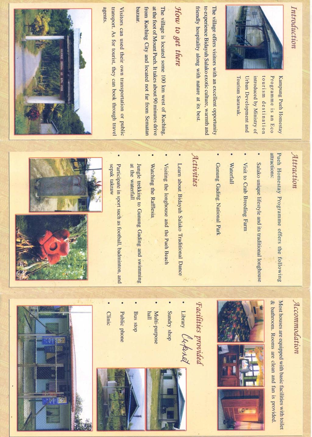
72 66
73 APPENDIX M: SYNOPSIS LIVELIHOOD STRATEGIES OF THE PUEH COMMUNITY FINAL SYNOPSIS INTERDISCIPLINARY LAND USE AND NATURAL RESOURCE MANAGEMENT Supervisors: Michael Eilenberg & Myles Oelofse Date: Number of words: 2528 Marie Louise Dahl Gydesen (ADK09011) Lis Hølzer (EM10089) Valentina Mandirola (EMS0920) Michael Okwalinga (ADK09022) Maja Lund Rasmussen 67
74 INTRODUCTION The village of Kampung Pueh is situated at the foot of Gunung Pueh (Mount Pueh) close to the mouth of Sungai Pueh (Pueh river). Kampung Pueh is located in The Federal State of Sarawak on the Island of Borneo, Malaysia. The village consists of 135 households of which 20 households are living in the one longhouse. The remaining 115 households in Kampung Pueh are living in individual houses. The total inhabitants of the village are approximately 841 persons (SLUSE 2010). The livelihood of the village is mostly farming, although Kampung Pueh is located by the South China Sea. The villagers cultivate both wet (swamp) and hill/dry rice and plant fruit trees the nearby orchards. Fishing is a part time occupation, and only around 20 individuals are involved. The fishing is usually done in the dry season from March to September. The traditional cash crops such as rubber, coconut, cocoa and pepper are also part of the subsistence of the village. Kampung Pueh s cash crops are subsidized by government agencies (SLUSE 2010). Another source of income derives from tourism, which started in Kampung Pueh in The homestay program was endorsed by the Ministry of Urban Development and Tourism under Homestay Association of Sarawak (HAOS). There are 14 families participating in the homestay program. The Kampung Pueh land area is under the Native Customary Rights (NCR) status. In 2003, the same year as the homestay program was introduced to the village, the Sarawak Land Consolidation and Rehabilitation Authority (SALCRA) started to develop the land by planting oil palms. More than 120 households were immediately affected. In the beginning many villagers worked in the oil palm plantation, but Indonesian workers have now replaced most of them. The villagers have also been facing changes regarding the nearby forest reserve. The Forest Department has prohibited the villagers from collecting and exploiting forest products in the area. According to the villagers, there was logging activities, which lasted for approximately five years in the 1990s. Kampung Pueh s water supply is based on a gravity-feed system, and the village has had access to 24- hour electricity since the 1980s (SLUSE 2010). RELEVANT ISSUES RELATED TO OUR RESEARCH Over the last decade the Malaysian state have promoted a development policy, which aims at becoming a developed country by In Sarawak this policy was interpreted as Konsep Baru meaning New Concept. The Chief Minister initiated it in 1994 ( The purpose of the project is to increase productivity and especially shifting from the traditional agricultural systems. The government focus is on oil palm plantations, interpreted both as State Program in the hands of SALCRA ( and as joint ventures between oil palm plantations, private companies, local communities and the state. In this case, in order to exclude the state from financial risk private companies are responsible for 60% of costs (and risks and surplus). By leasing locals are responsible for 30% of the plantation and government is responsible for the remaining 10%. The oil palm plantations are part of the development strategy and special attention is directed at financial growth. This shift is due to the lack of timber caused by the extreme aggressiveness of the timber logging companies in the previous decades (Colchester 1993: ). The international demand for palm oil also makes this shift an economically important activity. Other programs are also part of the government s 68
75 development strategy as traditional land use is disregarded and considered inefficient (Cooke 2002: ). This often poses conflicts as local communities are depended on small-scale farming practices that allow them to cultivate their land in a traditional manor (Osman 2000: ). The implementation of the government programs is based on a top-down approach, revealing a gap between that and the theoretical approach to rural development which put emphasis on decentralization, participation in decision-making and empowerment of local people (Hill & Birch-Thomsen 2005: Chapter: 1 & 2). The majority of the land surrounding Kampung Pueh is in the category Native Customary Land which means that people are not legal owners of land but have the right to use it. When the state proposes an oil palm program land tenure issues arise. Several communities are struggling for legal recognition of land that they are already using for subsistence. This puts locals in a position of dependence and high risk due to e.g. instability of global economy (Osman 2000: Ibid). The changes that this system creates at the livelihood strategies level therefore increase the locals vulnerability. MAIN OBJECTIVE OF OUR STUDY We want to assess the livelihood strategies of the villagers of Kampung Pueh in relation with the changes caused by various external actors e.g. the government. Our work will be concentrated around the following keywords: change, livelihood, vulnerability and power. RESEARCH QUESTIONS 1. What types of activities do the villagers engage in order to sustain their livelihoods (income generating activities + subsistence)? In order to assess the various livelihood strategies of the villagers of Kampung Pueh, we would like to begin our fieldwork by creating an overall understanding of the different activities that the villagers engage in. By doing so we will gain knowledge of the various activities and their importance, of the range of households involved in each activity and the extent to which the activities are meant for subsistence or as a source of income. We will then be able to direct our attention and further studies towards the activities that seem important. Kampung Pueh seems to juggle a whole range of activities, and it is not yet clear which of those provides an income or functions as a subsistence activity. The activities that we know of are; fishing, oil palm plantation, various sorts of agriculture and tourism. There may also be a portion of the local villagers that have migrated to other areas, and are sending remittances home, which create another source of cash income. We will be applying various kinds of methods, in order to collect the data we need to answer this question. These methods include: survey, PRA (mapping, transects walks, historical and seasonal calendar), interviews and semi-structured interviews. 2. Has the delineation of the forest reserve affected the community and in what way? It has come to our attention, that there has been a restriction on the forest reserve in Kampung Pueh. We are not aware if the villagers benefited from the forest before the prohibition, but we know that there has been 69
76 logging activities in the forest. We want to understand what resources are present in the forest, if the villagers used to benefit from these and whether they are trying to compensate for the lack of access and control over the reserve and the resources that are available there. We also find it interesting to investigate whether the prohibition is accepted and to what degree the villagers were included in the decision-making. The prohibition may be a sensitive issue that will not be studied easily. We intend to make use of qualitative methods such as transect walks, semi-structured interviews and participant observation in order to built trust and thereby increase our chances of understanding the situation and collecting intimate data on this subject. We will also be making use of specific PRA methods such as mapping and the making of a historical timeline. We will try to assess the forest quality with help from Dr. Greg. We may also try to collect data on this issue by including related questions in a survey. 3. How has tourism affected the lives of the villagers? We would like to know more about the Homestay Program in Kampung Pueh, how it was put forward and implemented and to which extent the villagers were involved in decision-making. We will also be focusing on the development of tourism in the village since Our research will be directed at financial as well as social and cultural changes in relation to tourism in Kampung Pueh. Whilst investigating this issue we will keep the following keywords in mind: globalization, progress, modernity, tradition and authenticity. We choose to investigate this issue, as we suspect that there may be certain power relations at stake, as other villages (Yea 2002: ) have been forced to make crucial changes in order to meet the demands of the tourist agencies this includes change in the current way of life (wearing traditional clothes, performing traditional dances, living in longhouses constructed in a traditional manor etc.). The program could also generate internal conflicts in the village, as some villagers are participating and some are not. To answer this question we will be making use of various methods; survey, PRA (historic timeline) participant observation, semi-structured interviews and structured interviews. 4. How has changes in land use affected agriculture and environment? We want to assess the agricultural patterns today and before the implementation of the oil palm plantation in order to get an overview of how the changes have affected their livelihood strategies. The question will help us understand the positive and negative effects of the scheme have on the community. If relevant, we will also try to assess whether oil palm plantation is affecting the water resources of the village (i.e. the river). This will be done by testing the water up-stream, in proximity of the plantation, down-stream and at the river mouth. These results will then be compared with the Proposed National Water Quality Standards for Malaysia ( If it is possible to obtain an EIA (Environmental Impact Assessment), we will try to compare the soil at marginal agricultural lands with the land now used for the oil palm plantation. This will be done in order to get an idea of the agricultural output before and after the implementation of the plantation. To answer this question we need both qualitative and quantitative methods; Natural science (soil and water testing), semi-structured interviews, PRA methods (Mapping, GPS-mapping, village mapping (past). 70
77 5. What are the social impacts of the changing land use due to the oil palm plantation? We suspect that the implementation of the oil palm plantation would have also brought on social changes in the Kampung Pueh community. We want to assess the question of rights and land tenure in order to better understand the situation. Also we want to know how the plantation was implemented and to what degree the villagers had a say in the matter. In relation to this we will also look at possible internal conflicts and hierarchies. We will try to reach an understanding of the government s persuasion-strategy and assess whether the leasing is economically profitable and long term sustainable for the locals. Since 2003 the local labor force has been almost completely replaced by Indonesian workers. Thus, we will be looking into why the labor force in the plantation was replaced. We will also assess the possible conflicts between the locals and the immigrants and the conflict resolution strategies. We will therefore be studying the various social impacts of the leasing of land. We will make use of semistructured interviews and possibly include a focus group discussion on the social changes related to the oil palm plantation. Knowing that this issue may be sensitive we will discuss our methods further whilst in the field. We will try to make a historical timeline in corporation with the villagers in order to understand the pace and seriousness of the oil palm implementation. Finally we will include questions on this subject in the survey. 71
78 DATA COLLECTION In order to answer the questions mentioned above we will make use of several social and natural science methods. In this section we will describe the methods that we will be using in general and not go in to further details on the specific methods already mentioned above. SAMPLING STRATEGY Because we are only in the field for ten days we will not be able to make a valid and complete analysis of the livelihoods of Kampung Pueh. Normally you would try to include 50% of the households, we will aim at including 25%. For qualitative analysis, sampling will primarily be done using the snowball method where one informant leads to the next. For the quantitative survey, the sampling method will be random sampling. We aim to speak with the head of the household. PARTICIPANT OBSERVATION Participant observation is a great way to try and reach an understanding of the community under study. We will be observing while directly participating in the local activities and practices. This method will be used during the entire field trip. GPS: MAPPING, VILLAGE MAPPING AND TRANSECT WALKS These methods will enable us understand the geography of the community. We plan to do the GPS mapping during the first day in the field. The transect walks are meant to support our GPS-mapping and understanding of the location. Afterwards we plan to do a session with an heterogenic group of people from the community that will be encouraged to draw two separate maps. The first map will depict the current state of the village and the second map will depict the state of the village before the major changes occurred in This is important because we will be able to get an impression of what major changes the villagers think have occurred over the years. INTERVIEWS AND SEMI-STRUCTURED INTERVIEWS Key informants like head of the village will be interviewed in order to get relevant information concerning the village, the people living there, the history, distribution of resources, concerns related to various issues under study. Other stakeholders that we will interview include government officials (forestry officer) and people heading the various rural development programmes in the village and relevant people working in The Tourist Homestay Program of Sarawak. QUESTIONNAIRE In order for us to get quantitative data about the livelihoods of the villagers a questionnaire will be applied. Most research questions will be included in this survey and the information we collect in the survey will help create an overview. Thus the survey will hopefully be carried out within the first few days in the field. SEASONAL CALENDAR A seasonal calendar will be constructed by individuals of Kampung Pueh in order to identify livelihood tasks and the time of the year, when these tasks are performed. The calendar will enable us to understand the seasonality of income. 72
79 HISTORIC TIME LINE This activity will be conducted by the various individuals to give an overview of the changes in the village over the years. FOCUS GROUP DISCUSSION A focus group discussion with 8-12 homogeneous participants will be held to help us get information on social issues related to changes and concerns. A question guide will be used to direct the discussion. SOIL ANALYSIS We will take soil samples from agricultural plots and compare those with the statistics of the EIA. Assessment of soil organic matter, PH, conductivity and plant available nutrients like N, P and K will be done. Also physical soil parameters like texture and colour will be assessed. WATER ANALYSIS Water samples will be collected from both up-stream and down-stream and mouth of the river in order to analyse the presence or absence of pesticides, ammonium, nitrate and other chemicals that are used on oil palm plantations. 73
80 BIBLIOGRAPHY Colchester, Marcus 1993 Pirates, Squatters and Poachers: The Political Ecology of Dispossession of the Native Peoples of Sarawak. In: The Political Ecology of Southeast Asian Forests: Transdisciplinary Discourses Vol. 3, No. 4/6. (Jul. - Sep. - Nov.): Oxford: Blackwell Publishing, p Cooke, Fadzilah Majid 2000 Vulnerability, Control and Oil Palm in Sarawak: Globalization and a New Era? In: Development and Change, Institute of Social Studies, Vol. 33, No. 2, Oxford: Blackwell Publishing, p: Hill, Trevor and Torben Birch-Thomsen 2005 Introduction to SLUSE, chapter one, Theoretical Background, chapter two. In: The SLUSE model of natural resource management: From theory to practice through field-based training - experiences from southern Africa. Pinetown, South Africa: SACUDE-SLUSE, University of KwaZulu-Natal, South Africa, p Osman, Sabihah 2000 Globalization and Democratization: The Response of the Indigenous People of Sarawak. In: Third World Quarterly. Capturing Globalization Vol. 21, No. 6, London: Routledge, p Yea, Sally 2002 On and off the Ethnic Tourism Map in Southeast Asia: The Case of Iban Longhouse Tourism, Sarawak, Malaysia. In: Tourism Geographies Vol. 4, No. 2. London: Routledge, p SLUSE 2010 Webpages: SLUSE Course Downloaded: February 22 nd Downloaded: February 21 st
81 APPENDIX A RESEARCH MATRIX Issue Questions Data Needed Methods Informants Livelihood strategies and households 1. What types of activities do the villagers engage in in order to sustain their livelihoods (income generating activities + subsistence)? What types of activities and who are involved? No. of households engaged Economical importance of activities Semi-structured interview Resource mapping #1 Seasonal calendar Survey #1 PRA Ranking Headman Villagers (survey: individual houses and longhouse) Sampling Methods Snowballing Random Sampling (survey) Forest restrictions and relating conflict 2. How has the delineation of the forest reserve affected the community? Resources present in and specifics of the forest reserve NTFPs and wild animals previously and presently used Is the forest prohibition upheld? Village involvement in decision making Compensation for lack of access? Transect walks Semi-structured interviews Informal conversation Mapping (GPS and village mapping #1) Survey #1 Participant observation Historic timeline Headman or somebody appointed by the Headman Villagers Forest officer Snowballing Random Sampling (survey) Tourism 3. How has tourism affected the lives of the villagers? Changes (non-economic, economic, cultural, social) No. of households involved Implementation of the Home Stay Programme (selection, involvement) Longhouse compared to individual living Progress and modernity vs. tradition and authenticity Increase/decrease of tourism Semi-structured interviews Historic timeline Survey #1 (income) Participant observation Home Stay hosts Village guides Other local villagers Tourist agency Snowballing Random sampling (local villagers) 75
82 Environment and agriculture 4. How has changes in land use affected agriculture and environment? Agricultural systems Soil-quality Water-quality (upstream/downstream) Water usage Positive and negative aspects of the changing land use Quality of non-leased land used for agriculture Soil-analysis Water-analysis Semi-structured Interview Village mapping #2 (past) Farmers Villagers Purposeful sampling (Water and soil analysis) Snowballing Social issue related to change in land use 5. What are the social impacts of the changing land use due to the oil palm plantation? Information on land tenure Village involvement in decision making Internal conflicts Conflict between villagers and immigrants? Why the Indonesian workers replaced the local work force Social impacts of the leasing Is leasing economically profitable Focus group-discussions Semi-structured Interviews (Survey #1) Historic timeline #1 Local villagers Indonesians Snowballing (Random sampling Survey #1) 76
83 APPENDIX B TIME SCHEDULE Date: (March 2010) Thursday 4 th Friday 5 th Activity and location: Kuching: Meet Malaysian students Tasks: Agree on research topic and questions Group meeting and evaluation Persons in Charge Lis & Michael Notes: Saturday 6 th Kuching: Plan field work with Malaysian students Discuss time schedule Discuss approach methods Group meeting and evaluation Maja & Chris Sunday 7 th Departure Lundu at am Kampung Pueh (Afternoon) pm Welcome ceremony in Kampung Pueh First impressions of village GPS mapping + transect walk Meet village headman Find out how to conduct Questionnaire Village mapping (past and present) Group meeting and evaluation Valentina & Carol Arrange appointment for interview with headman Arrange appointment for participants for PRAs Monday 8 th Kampung Pueh Questionnaire Interview #1 (Village headman) Seasonal calendar Historical timeline Group meeting and evaluation Tuesday 9 th Kampung Pueh Questionnaire Interview #2 Interview #3 Group meeting and evaluation Marie & Lis Michael & Maja Arrange appointments for Mondays interviews Arrange appointment for Tuesdays interviews Find people to do PRA With Tuesday Wednesday 10 th Lundu Kampung Pueh. Meeting with officials (interviews # 4 and # 5: SALCRA, Tourist agency) PRA Ranking exercise #1 PRA Ranking exercise #2 Group meeting and evaluation Chris & Valentina Arrange appointment for Wednesdays interviews Prepare gear for testing Wednesday Thursday 11 th Kampung Pueh Soil testing Interview #6 Interview #7 Group meeting and Carol & Marie Arrange appointments for Thursdays interviews 77
84 evaluation Friday 12 th Kampung Pueh Interview # 8 Interview #9 (Animal survey) Group meeting and evaluation Saturday 13 th Kampung Pueh (Vegetation sampling (Forest evaluation. Interview # 10)) Group meeting and evaluation Sunday 14 th Kampung Pueh Interview #11 Water sampling Group meeting and evaluation Monday 15 th Kampung Pueh PRA Focus group PRA Venn Diagramme Group meeting and evaluation Lis & Michael Maja & Chris Valentina & Carol Marie & Lis Arrange appointment for Saturdays interview Prepare gear for testing Sunday Find villagers for PRA events Sunday Prepare short presentation Tuesday 16 th 9-13 Lundu Kampung Pueh Presentation of findings Group meeting and evaluation Michael & Maja Wednesday 17 th Kampung Pueh Departure 2 pm Sematan Farewell gathering with villagers Group meeting and evaluation Chris & Valentina 7 pm arrive in Kuching Thursday 18 th Kuching Supervising Group meeting and evaluation Carol & Marie Friday 19 th Kuching Supervising Departure Kuching Appendix C LIST OF METHODS AND TOOLS FOR THE FIELDWORK Method: Number of activities People involved Semi-structured Interviews Approx. 12+ interviews Villagers, officials, Questionnaire 30 households Households PRA Mapping Exercise 2 maps (past and present) Villagers (heterogeneous group) 78
85 PRA Ranking Exercise 2 Rankings Villagers (heterogeneous group) Seasonal Calendar 1 calendar Villagers (heterogeneous group) and maybe headman Historical Timeline 1 timeline Villagers (heterogeneous group) and maybe headman GPS and Transect walk During first impression of the village (Headman, villagers) Soil Analysis A soil specialist Water Analysis Focus Group Discussion Forest Resource Assessment Walk with Dr. Greg Dr. Greg TOOLS For interviews: Notebook Pen Mp3 or other recorder for registration Interview guideline paper For PRAs: Poster paper Coloured markers Sticky tape Coloured Post-its Seed or stones for ranking For Participant Observations: Digital Camera Note books Binoculars Sample container Tags for Samples GPS Soil & water Analysis Soil kit & Water kit Containers for samples GPS A water specialist A homogeneous group of villagers 79
86 APPENDIX D QUESTIONNAIRE SURVEY - LIVELIHOOD ANALYSIS OF KAMPUNG PUEH Who we are: Two Malaysian students Caroline and Christina, three Danish students Marie, Lis and Maja, one Italian student Valentina, one Ugandan student Michael. The students are all participating in a interdisciplinary course and are required to apply different methods. The students are here to learn. The information gathered will be handled anonymously. Feel free to ask them anything. THANK YOU FOR HELPING THE STUDENTS! Purpose: For the students to get an overview of the village activities. Name of informant: Age: ٱ ٱ ٱ ٱ 50+ Gender: ٱ F ٱ M Do you live in: ٱ Individual house ٱ Longhouse Livelihood strategies and households 1) How many people are part of this household? ٱ 1-5 ٱ 6-10 ٱ 10+ 2) Are there any household members that are not living in this house? ٱ Yes ٱ No a) If yes, why? ٱ Wanted individual housing ٱ Labour migration ٱ Education ٱ Other reason: b) If yes, do the absent members contribute financially to your household? ٱ Yes ٱ No If yes; How important is their contribution: ٱ Very important (we couldn t make it without it) ٱ Important (the contribution is a great help) ٱ Not important (we could manage without it) c) If yes, do the absent members contribute in other ways to your household? ٱ Yes ٱ No If yes, how? and how important is their contribution? ٱ Very important (we couldn t make it without it) ٱ Important (the contribution is a great help) ٱ Not important (we could manage without it) 4) Which activities provide food for your household? ٱ Paddy rice ٱ Hill rice ٱ Home garden ٱ Fruit tree ٱ Hunting/gathering ٱ Fishing ٱ Livestock ٱ Other: 5) Which activities provide an income for your household? ٱ Paddy rice ٱ Hill rice ٱ Home garden ٱ Fruit tree ٱ Hunting/gathering 80
87 Fishing ٱ Livestock ٱ Tourism ٱ Oil palm labour ٱ Logging ٱ Wage labour ٱ Pension ٱ Other: ٱ Pepper ٱ Coconut ٱ Cocoa ٱ Rubber ٱ crop: Cash ٱ Forest restriction 6) Are you aware of the restrictions in relation to the forest? ٱ Yes ٱ No 7) Did you use the forest before the restriction? ٱ Yes ٱ No If yes, how did you use the forest? ٱ For hunting ٱ For gathering ٱ Rituals ٱ Logging ٱ Fuel wood Other: ٱ 8) Do you know if members of the community are still using the forest? ٱ Yes ٱ No 9) Do you still use the forest? ٱ Yes ٱ No 10) Were you or any of your fellow villagers involved in the forest management decision-making? ٱ Yes ٱ No If yes, how much influence did you or the other villagers have in the process? ٱ High ٱ Medium ٱ Low Tourism 11) Do you think that tourism has changed your village in any way? ٱ Yes ٱ No ٱ( traditional Living standards (more ٱ modern) Living standards (more ٱ Sense of community ٱ Activities ٱ Dressing ٱ how? If yes, Village conflicts in relation to tourism ٱ Other: 12) Do you think that tourism is good for your village? ٱ Yes ٱ No 13) Is your household involved in the Homestay Program? ٱ Yes ٱ No 14) Were you or any of your fellow villagers involved in the decision-making regarding the Homestay Program? No ٱ Yes ٱ If yes, how much influence did you or the other villagers have in the process? ٱ High ٱ Medium ٱ Low Social issues 15) Do you have a land title for the land you cultivate? ٱ Yes ٱ No 16) Do you lease some of your land for the oil palm plantation? ٱ Yes ٱ No If yes, what are the main reasons? Economic benefits ٱ Obligation ٱ Community decision ٱ Expectation to acquire the land title at the end of the program ٱ Agricultural inputs ٱ Other: ٱ ٱ I did ٱ plantation? 17) Did you or any other villager participate in the decision-making regarding the implementation of the oil palm Other villagers participated ٱ I don t know 18) How would you define the level of influence you/another villager had? ٱ High ٱ Medium ٱ Low 81
88 Appendix E LIST OF POSSIBLE INTERVIEWEES SUBJECTS/STAKEHOLDERS Headman Forest officers Medicinal men Tourist office Kuching Local guide Household into homestay programme Oil palm responsible Famer working on oil palm plantation Famer cultivating cash crop Headman of longhouse Fishermen Indonesian immigrants APPENDIX F GUIDELINE FOR SEMI-STRUCTURED INTERVIEW HEADMAN OF KAMPUNG PUEH 1. How long have you been the headman of Kampung Pueh? 2. What do you do? 3. Where do you live? 4. How many people does your household consist of? A. Livelihood strategies and households 1. What are the major activities in Kampung Pueh? 2. What other kinds of activities do the villagers engage in? 3. Which of these are meant for subsistence and which are meant for cash income? 4. How many households are involved in each activity? 5. What development schemes have been implemented in the village? 6. Why are some people living in a longhouse and others in individual houses? 7. Do many people migrate to other areas in Malaysia or emigrate to other countries - why? 8. Do farmers receive government subsidies (inputs, financial help etc.)? 82
89 B. Forest restrictions and relating conflict. 1. When was the forest area restricted from use? By who? 2. Were the villagers involved in the decision-making related to the forest restriction? 3. Did you (the village) use the forest before the access was restricted? 4. And what was the main purpose of the previous use? 5. Has the restriction of the forest reserve had any influence on village life? 6. Why do you think the forest reserve was restricted from use? 7. Is the forest prohibition upheld? 8. Are the villagers involved in the management of the forest? C. Tourism 1. Describe how The Homestay Program works 2. How long has Kampung Pueh been involved in tourism? 3. What social and cultural changes have occurred since tourism started? 4. How much income do the villagers get from the tourism program? (subsidies, money ect.) 5. How many households are involved in this program? 6. How were the households selected? 7. What has been the trend of tourism growth in the village? 8. Why did you/they decide to become a part of the program? 9. How has the program affected the village? 10. How has the program affected the people involved with the tourists? 11. How has the tourists responded to the village? 12. How has the village responded to the tourists? 13. Have there been any major changes in behavior/dressing/cultural activities? D. Land Tenure. 1. What have been the major changes of land use in the past few decades? 2. How has it influenced the development of the infrastructure in the village? 3. How much land do the villagers cultivate (average)? 4. How many people have a legal title for their land? (Explain) 5. How much land do the villagers lease out to the plantation scheme? 6. What kinds of changes (if any) have the establishment of the oil palm plantation brought? 83
90 7. Has the income of the villagers become better, unchanged or worse, since the establishment of the plantation scheme? 8. Are their major conflicts due to the NCR land tenure? Are they still going on? 9. What do you expect to happen in the future when thinking about the plantation scheme? E. Environment. 1. Do you think that the oil palm plantation affect the environment in any way? How? APPENDIX G GUIDELINE FOR SEMI-STRUCTURED INTERVIEW FOREST OFFICER 1. How long have you worked in the Pueh Forest reserve? 2. What is your main function with regard to the reserve? 3. Are you in dialog with the nearby villagers? 4. How is the restriction of the forest upheld? 5. Are there consequences if the prohibition is disregarded? 6. What could they be? 7. When was the forest reserve created and when was the access restricted? 8. Was the villagers opinion studied? 9. What kind of resources are found in the forest? (Animals, plants (firewood, medicines, building materials, cash income)) 10. Has the forest reserve been logged in recent years? APPENDIX H GUIDELINE FOR SEMI-STRUCTURED INTERVIEW LOCAL TOURIST GUIDE 1. What is your main activity? 2. Where do you normally take the tourists? 3. Could the forest reserve be of interest in this regard? 4. Have you used the forest reserve previously? 84
91 5. Why do you think it is prohibited to enter and use the forest reserve? 6. What do you think would happen to the forest reserve if the villagers were permitted access? 7. What are the possible resources found in the forest reserve? 8. Do you think that the prohibition is upheld? a. Why/why not? 9. How has tourism affected the lives of the villagers? APPENDIX I GUIDELINE FOR SEMI-STRUCTURED INTERVIEW VILLAGERS INVOLVED IN THE HOMESTAY PROGRAM 1. How long have you participated in the program? 2. Did you decide to become a part of the program yourself? 3. Did you make any changes to your home, your clothes, your cultural life, when you entered the program? 4. Who organizes the tourists? 5. Do you decide when you want to participate? 6. Could you describe the major benefits of the program? 7. Could you describe the major drawbacks of the program? 8. Has your livelihood changed since you started the program? 9. Have you experienced any internal problems (within the village) related to tourism? 10. What was your main source of income before the program? 11. Apart from tourism program what other activities are you involved in? APPENDIX J GUIDELINE FOR SEMI-STRUCTURED INTERVIEW TOURIST 1. Have you tried the Homestay program before? 2. What do you think of the Homestay program in Kampung Pueh? 3. What are you looking for when choosing a Homestay instead of e.g. a hotel? 4. What do you expect to experience when visiting local communities? 5. Does The Homestay feel authentic/traditional to you? 85
92 6. Have you heard about local people changing their habits to become more authentic for the pleasure of tourists? 7. What do you think about that? APPENDIX K GUIDELINE FOR SEMI-STRUCTURED INTERVIEW TOURIST OFFICE, KUCHING 1. Why was Kampung Pueh selected to participate in the home stay program? 2. How many villages are part of your Homestay Program? 3. How do you choose which villages should be part of the program? 4. What qualities do you find particularly important when choosing a village? 5. How do you decide which households should be involved? 6. Do you ask locals to be guides for the tourists? 7. Did you corporate with local villagers of Kampung Pueh when deciding the attractions and specific cultural entertainment? 8. How were locals involved? 9. Since their enrolment in 2003, how has the tendencies been (How many tourists and how many households?)? 10. Do you get feed back from the tourists? 11. Are there any requirements of the villagers participating? (Clothes, homes, livelihoods) 12. Do you ask people to make changes in order to be more attractive for the program? 86
93 APPENDIX L GUIDELINE FOR SEMI-STRUCTURED INTERVIEW HOUSEHOLD HEAD Livelihood strategy and households 1. What are the sources of income to your household? 2. What are the main crops you grow? Land tenure. 1. How many acres of land do you own? 2. Do you lease out land? 3. If so to who? 4. How do you use your land? 5. Previously did you use the leased land for agricultural activities? 6. If yes, what is the quality of the land you are cultivation now compared with the land you used to cultivate? 7. Have yields changed? 8. Have your working habits changed? 9. Are you cultivating the same amount of land as before the plantation? 10. Do you experience any effects of the oil palm plantation? (E.g. nutrient run off, polluted water for irrigation) Forest restriction 1. Did you use the forest before the access was restricted? 2. And what was the main purpose of the previous use? 3. Has the restriction of the forest reserve had any influence on your life? 4. Why do you think the forest reserve was restricted from use? 5. Is the forest prohibition upheld? 6. Are the villagers involved in the management of the forest? 7. If so how? 87
94 Social issues related to change in land use. 1. What are the social impacts of the leasing of your land to the oil palm scheme? 2. Have you had any conflicts with the Indonesian immigrants working with the oil palm scheme? 3. Is the leasing of the land economically profitable? 4. Are you involved in decision making on land use? Tourism 1. How do you feel about the Home Stay program in your village? 2. Are you involved in the program? 3. Would you have liked to become a part of it? a. If not, why not? b. If yes, why? 4. Do you think the arrival of tourists has changed anything in your village? a. If yes, in what way? 5. Do you think the people involved in the program have changed their way of life, since entering the program? Environmental issues 1. What do you think are the effects of oil palm plantations to the environment? APPENDIX M GUIDELINE FOR SEMI-STRUCTURED INTERVIEW OIL PALM PLANTATION RESPONSIBLE 1. How long have you worked in the oil palm industry? 2. How long have you worked in the plantation in Kampung Pueh? 3. How is the plantation managed with regard to input (Chemicals, incl. pesticides, fertilizers)? 4. What is the yield of this particular plantation compared with others? 5. What soil management practices do use on these plantations? 6. How has the oil palm scheme improved the lives of villager working in it? 88
95 APPENDIX N GUIDELINE FOR SEMI-STRUCTURED INTERVIEW MEDICINE (WO)MAN 1. How long have you been practicing using herbal medicine? 2. Where do you collect your medicine? 3. Has the forest reserve restriction affected (positive of negative) the amount and quality of the forest products the community need? 4. Do you still have access to the forest reserve? 5. Who collect the medicines for the community? 6. Have you encountered major changes in heath problems in the community in the last decade? 7. If yes. What do you think are the main causes? 8. In which way do you think the development programs affected the community in the last 10 years? APPENDIX O GUIDE FOR PRA METHODS MAPPING EXERCISE Purpose: To get a general overview of the village before and after implementation of the development schemes. Obectives: Two maps: The 1 st map will depict the current state of the village, including: - The infrastructures - The water points - The forest reserve - The oil palm plantations. - Community boundaries - Agricultural division (cash crops, homegardens, rice, orchard..etc) - Fishery areas - Household distribution (longhouse, individuals, Indonesians..etc) - Land characterization (slope, swampy, sandy areas..etc) - Other important natural resources - Household aggregations etc. The 2 nd map will depict the state of the village before implementation of development schemes (i.e. Oil palm Plantation, Tourism, Forest Reserve restriction), including: 89
96 - Includes all the above without plantations. Participants: ten persons, two participants of the Wet/hill rice scheme, two participants of the Oil Palm scheme, two participants of home stay program, two people not participating in the schemes and two youth participants, two fishermen. Material: - Big paper - Color pencils - Post it RANKING EXERCISE Purpose: To identify the main income generating activities and food and to rank these according to importance and other relevant factors identified by the villagers. Participants: Maximum 10 persons, two participants of the Wet/hill rice farms, two participants of the Oil Palm scheme, two people not participating in the schemes, two participants of home stay program, two fisherman. Expected results: a schematic presentation of the major sources of food and income of the village. Ranking Exercise Example: (In each space they will put a number of sticks between 1 and 5, when 1 is the less important) Food Security Cash Generating Activities Paddy Rice Upland rice Oil palm plantation scheme (Income from leasing land) Oil palm plantation (Salary) Rubber Cocoa Coconut 90
97 Pepper Fruit Trees Home garden Products Hunting / gathering Fishing Shrimp Tourism Logging NTFPs Remittance Waged labour SEASONAL CALENDAR EXERCISE Purpose: To create a schematic presentation of livelihood tasks and income of the villagers. Participants: Maximum 8 persons per exercise. The participants will be divided into four Groups: Participants of the Wet/hill rice scheme, participants of the Oil Palm scheme, participants of the home stay program and people not participating in the schemes. Expected results: A schematic presentation a working year of the four groups of people, including main activities, levels of income and expenditures. Seasonal Calendar: Activities Jan Feb Mar Apr May June July Aug Sept Oct Nov Dec Paddy rice (plant) Upland rice Oil palm Rubber Cocoa Coconut Pepper Fruit trees 91
98 Home garden Activities Fishing Shrimp Tourism Logging NTFPs Hunting/ gathering Market in Sematan/Lundu To BUY products Market in Sematan/Lundu to SELL products Subsides from governmental Agencies School Remember to add a specific color related with different activity like (harvest, plan, fertilize, other management, etc) HISTORICAL TIMELINE VENN DIAGRAM Purpose: Create a kind of social map of the community in order to identify stakeholder relations (internal external). Participant: Heterogeneous group of villagers. Expected result: Visual map of relations Material: - Big paper - Color pencils - List of stakeholder FOCUS GROUP Purpose: Explore a research topic to obtain a deeper understanding of the matter Participant: Homogeneous group of people. From 8 to 10 participants; will be decided in the field. 92

99 Expected result: Not yet specified APPENDIX P WATER QUALITY STANDARDS 93