GEO WEEK KYOTO, JAPAN Monday 29 October, EU Africa cooperation in Earth Observation
|
|
|
- Jordan Robbins
- 5 years ago
- Views:
Transcription


1 GEO WEEK 2018 KYOTO, JAPAN, EU Africa cooperation in Earth Observation Promoting GEOSS and COPERNICUS in NAMEBA: the GEO-CRADLE EU project and GEO Initiative Dr. Haris Kontoes GEO-CRADLE Project Coordinator National Observatory of Athens Side event organised by the European Commission / EASME


2 Why promoting GEOSS and COPERNICUS is important? The continuous provision of useful, accurate and timely information through coordinated and sustained Earth Observation together with INSPIRE data, Copernicus, and GCI information is a key enabler for informed decision making, in response to regional challenges and towards the achievement of the UN SDGs and the implementation of the relevant EU Directives.
 and develops")


3 The GEO-CRADLE contribution GEO-CRADLE coordinates and integrates state-of-the-art EO activities in the regions of North Africa, Middle East, and Balkans (ΝΑΜΕΒΑ) and develops links with GEO related initiatives towards GEOSS, contributing amongst others to EuroGEOSS and AfriGEOSS. GEO-CRADLE brings together key players representing the entire EO value chain and promotes the uptake and exploitation of innovative EO activities in NAMEBA through: Cooperation Awareness raising Capacity building Open data sharing principles Interoperability

4 The GEO-CRADLE links


5 The GEO-CRADLE overview Regional Data Hub with >25,000,000 datasets 11 countries analysed with the maturity indicators methodology Capacity building Regional cooperation 16 regional workshops Networking Platform with >200 stakeholders from 29 countries 4 large scale regional initiatives with capacity building and delivery of innovative services in support of 11 UN SDGs
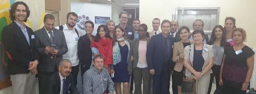
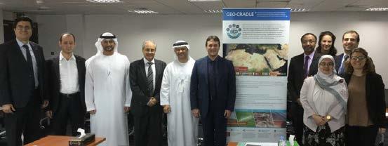
6 The GEO-CRADLE Capacity Building & Stakeholders Engagement 16 Regional Workshops have taken place so far in the North Africa, Middle East & the Balkans: advocating for free & open data policies in support of GEO & INSPIRE principles supporting knowledge sharing - capacity building providing participants with a unique cross-sector networking opportunity (e.g. an enhanced cooperation between academia and industry) identifying the potential local challenges and needs that can be addressed by Earth Observation enhancing growth and innovation in the geo-information sector enabling more informed decision making Date Location 28/04/2016 Cairo, Egypt 14/07/2016 Novi Sad, Serbia 26/09/2016 Tirana, Albania 17-18/10/2016 Rabat, Morocco 19/10/2016 Timimoun, Algeria 16/11/2016 Limassol, Cyprus 03/01/2017 Chişinău, Moldova 02/02/2017 Abu Dhabi, United Arab Emirates 24/03/2017 Sofia, Bulgaria 26/04/2017 Brussels, Belgium (Industrial market) 09/05/2017 Magurele, Romania 25/05/2017 Cairo, Egypt 14/09/2017 Tel Aviv, Israel 07/12/2017 Tunis, Tunisia 15-16/03/2018 Istanbul, Turkey 04-05/06/2018 Thessaloniki, Greece (3rd South- Eastern Europe GEO Workshop))


7 The GEO-CRADLE Capacity Building & Stakeholders Engagement
8 The GEO-CRADLE Networking Platform

9 The GEO-CRADLE Networking Platform Available for the first time in ΝΑΜΕΒΑ with open access: inventory of regional capacities profiles of stakeholders assessment of country maturity potential partnerships


10 The GEO-CRADLE Networking Platform: focus on North Africa 30 stakeholders in North Africa: 6 in Morocco + 14 in Tunisia + 10 in Egypt

11 The GEO-CRADLE Networking Platform: search example Filters: Region: North Africa Thematic Area: Food security Role: Value-adder Results: 12

12 The GEO-CRADLE Networking Platform: search example Example Profile: Centre National de la Cartographie et de la Télédétection Sections: Details Activity Focus Capacities National Activities Engagement in GEO-CRADLE Location
13 The GEO-CRADLE Regional Data Hub

14 The GEO-CRADLE Regional Data Hub Available for the first time in ΝΑΜΕΒΑ with open access: integrated Search and Display mechanism with unified, centralized and user-friendly interface full interoperability with GCI and GEO DAB APIs, as well as connection with data available through the GEO-CRADLE project pilots, as well as through regional data providers advanced functionalities by integrating DKAN open-source data web management platform with the GEO DAB APIs Focal node in the region in the context of GEOSS and Copernicus implementation.

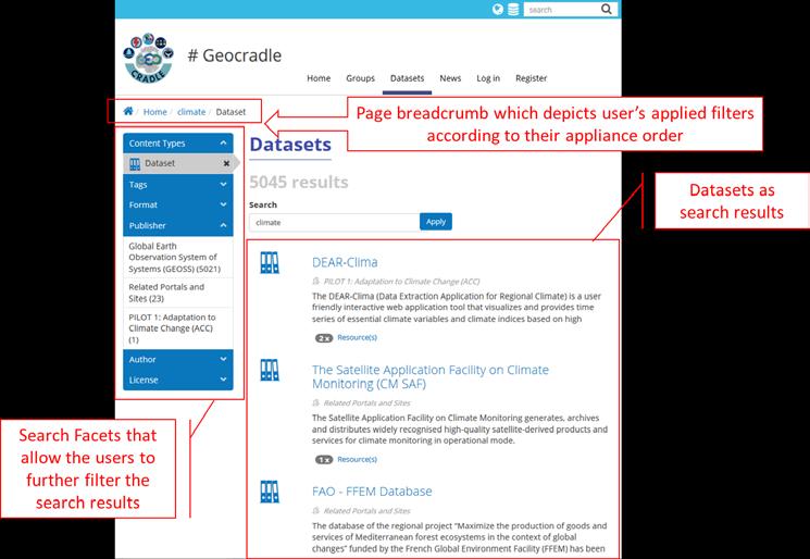

15 The GEO-CRADLE Regional Data Hub: search example


16 The GEO-CRADLE Regional Data Hub: search example

17 The GEO-CRADLE Regional Data Hub: data & data providers DATA Regions of Interest Balkans Middle East North Africa Thematic Areas Climate Change Food Security & Water Extremes Raw Materials Energy EO Data Categories Space borne Ground based Modelling GEO-CRADLE DATA PROVIDERS GEO-CRADLE Survey 10 national portals and sites National portals in total: 42 Desk Research 32 national portals and sites 12 continental and global portals and sites GEOSS Portal 25,216,989 datasets
18 The GEO-CRADLE Regional Data Hub: National sites and portals Adaptation to Climate Change Improved Food Security and Water Management Better access to Raw Materials Better access to Energy Balkans Middle East North Africa Total number of portals and sites: 42
19 The GEO-CRADLE Regional Data Hub: Prioritized Portals a/a Portals Brokered by GEOSS 1. Danube Reference Data and Services Infrastructure (DRDSI) 2. Eusoils 3. Albania - GEOportal Pending 4. Montenegro - GEOportal Pending 5. Croatia - GEOportal Pending 6. Moldova - National geospatial data of Moldova 7. FYROM Soil information system Pending 8. Bosnia & Herzegovina - GEOportal Pending 9. REP of SRPSKA - GEOportal Pending 10. Slovenia- Portal and Forest Data Viewer 11. Cyprus - Geoportal 12. Cyprus - Air quality 13. United Arabic Emirates - Abu Dhabi Geospatial Portal and Map Viewer Pending 14. Poland - Central geological Db Pending
20 The GEO-CRADLE Pilots

 Access to Solar Energy (SENSE) End users & stakeholders")
21 The GEO-CRADLE Pilots vs UN SDGs GEO-CRADLE Thematic Areas in support of the UN SDGs Pilots applicable & adaptable to all countries Adaptation to Climate Change (ACC) Improved Food Security Water Extremes Management (IFS-WEM) Access to Raw Materials (ARM) Access to Solar Energy (SENSE) End users & stakeholders engagement

22 GEO-CRADLE Pilot 1: Adaptation to Climate Change

23 GEO-CRADLE Pilot 1: Adaptation to Climate Change Example: Tunis Variable: Temperature (2m)
 up to")
24 GEO-CRADLE Pilot 1: Adaptation to Climate Change Example: Tunis Variable: Temperature (2m) up to 2100.

25 GEO-CRADLE Pilot 1: Adaptation to Climate Change


26 GEO-CRADLE Pilot 1: Adaptation to Climate Change Select date


27 GEO-CRADLE Pilot 1: Adaptation to Climate Change Horizontal and vertical dust forecasts with satellite assimilation


28 GEO-CRADLE Pilot 1: Adaptation to Climate Change Engagement of end-users and key stakeholders


29 GEO-CRADLE Pilot 2: Improved Food Security-Water Extremes Mgmt Click on FREE ENTRANCE and hit Dewetra on the left pane to enter the main platform


30 GEO-CRADLE Pilot 2: Improved Food Security-Water Extremes Mgmt Example: Morocco Variable: Flood hazard 100 years

31 GEO-CRADLE Pilot 2: Improved Food Security-Water Extremes Mgmt


32 GEO-CRADLE Pilot 4: Access to Solar Energy Solar Atlas for Egypt


33 GEO-CRADLE Pilot 4: Access to Solar Energy PAR Atlas for Egypt


34 GEO-CRADLE Pilot 4: Access to Solar Energy Engagement of end-users and key stakeholders
35 Funding opportunities


36 Funding opportunities


37 The GEO-CRADLE Roadmap


, in")

38 The GEO-CRADLE upgrade: Project->Community Activity->Initiative GEO Capacity Building in North Africa, Middle East, Balkans, and Black Sea A continuation and extension of the work of the GEO CRADLE which will capitalise, sustain and scale-up its results, as well as key outcomes of other relevant EU flagship projects and initiatives (e.g. GEOGLAM, NextGEOSS, ERAPLANET, EuroGEOSS, AfriGEOSS, GEO-VENER, EO4SDG), in support of the 3 GEOSS priorities, namely CC, DRR and SDGs. Geographic extension Thematic extension Operational Maturity Black Sea Disasters Management & Water Resources Management Operationalisation of services to the engaged users
39 The GEO-CRADLE tomorrow Leverage the EU investments (Copernicus, DIAS, GCI, INSPIRE) and actions as GEO-CRADLE for enabling and effectively support the engagement of the EO European private sector and research in the regional markets. Make the large EU investments especially in Copernicus available to the wider End User communities. Capitalise on the outcomes of regional actions as GEO-CRADLE and other similar GEPs in implementing geographical diversification strategies for capacity building and service prioritization, in an attempt to meet the actual local needs, and address the uptake of Earth Observations in decision making. Facilitate potential synergies with local interlocutors thus creating impact into the implementation, monitoring, and reporting of the UN SDGs. Sustain the service development, openness of data, sharing of data and know how, integration of regional infrastructures and portals, networking and engagement of the local actors in exploiting the funding instruments.


40 Side event organised by the European Commission / EASME