Soil Moisture Monitoring for Agricultural Risk Assessment in Canada
|
|
|
- Clyde Wiggins
- 5 years ago
- Views:
Transcription


1 Soil Moisture Monitoring for Agricultural Risk Assessment in Canada Catherine Champagne, Patrick Cherneski, Trevor Hadwen, Antoun El Khoury National Agroclimate Information Service Science and Technology Branch

2 Agricultural Production in Canada 65 million hectares of land concentrated mainly along the US border 55% of land is crop land (primarily oilseeds and grains), 30% pasture Climate risk is significant large land area, sparse monitoring and primarily rain-fed cropping system Single growing season: April to October Business risk management support is a major role of government


3 Soil Moisture and Extremes 2011 Saskatchewan 2002 Saskatchewan 2006 Manitoba 2009 Alberta Canada s large size and geographic diversity means parts of the country are impacted by climate risk most growing seasons Saskatchewan 2012 Ontario

4 National Climate Production Risk Assessment Inputs: climate station based maps Drought indicators (PDSI, SPI) Soil moisture from water budget models Satellite based surface soil moisture, NDVI Media reports Crowd sourcing (Agroclimate Impact Reporter)
 develop best practices for remote sensing of key agricultural")
5 Global Monitoring: GEOGLAM G20 Ministers of Agriculture initiative to reduce food price volatility by providing transparent, consistent information on global crop outlooks Joint Experiment for Crop Assessment and Monitoring (JECAM) develop best practices for remote sensing of key agricultural indicators

6 Drought Monitoring


")
7 Integrated Canadian Crop Yield Forecaster Current Inputs General Crop cover NDVI Soil Moisture Near real time Climate data Soil Map Historical climate data Specific Crop cover Yield Forecasting Model Management Data ( seeding date, irri. etc) Weather predictions (GEM/ ENSO etc.) Future Inputs Other RS Products (f APAR, etc) Flexible Data Handling Capacity 12/02/2011 7
 Produce Weekly, Biweekly and Monthly")

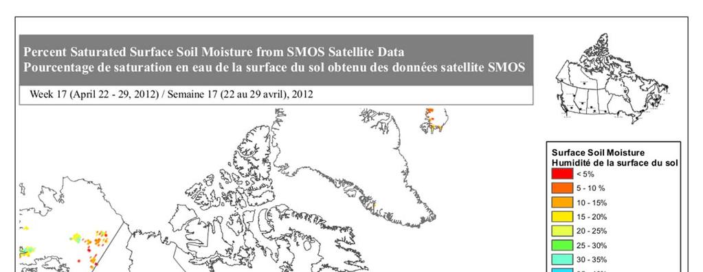
8 SMOS Surface Soil Moisture (animated time series 2013) Produce Weekly, Biweekly and Monthly estimates April 1 to November 30 in NRT Operationally produced data set to support programs and services


9 Near Real Time Monitoring Image courtesy Portage Online


10 Multi-Scale Satellite Surface Soil Moisture Monitoring Courtesy Heather McNairn Radarsat SAR active microwave


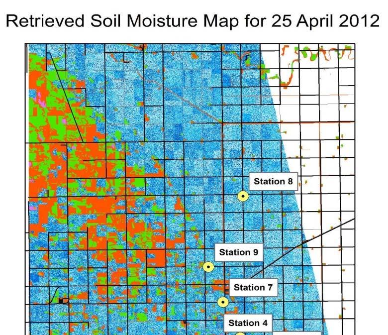
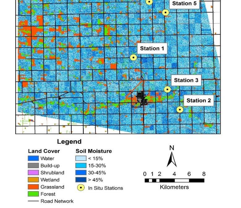
11 RISMA In Situ Validation Network Data available in Near Real Time 3 Hydra probes each installed at multiple depths: 0 5cm 20cm 100cm 5cm 50cm 150cm (Sask Pasture)
12 Maps, information products are communication tools for decision making at a national scale, not for individual farmers Tools for precision agriculture, producer decision support are largely provided by private sector


13 Defining Risk Conditions: Soil Moisture Anomalies Famers are adapted to normal need to better define abnormal to isolate where risk is occurring Satellites have short data records! Need to Define Normal

14 Soil Moisture Anomalies from SMOS 4 year Baseline
15 2012 Drought in Southern Ontario


16 Too Wet To Seed 2010 and SMOS Soil Moisture Anomalies
 capture regional scale risk events well Can")
17 How does SMOS capture risk events? Soil moisture anomalies (from four year baseline) capture regional scale risk events well Can inter-calibrate data sets to get a longer time series for forecasting, risk assessment?
18 Multi-Sensor History of Soil Moisture SMMR K Band 15km Res C/X Band 150 km Res SSM/I F8: present C Band, 50km Res C/X Band, 60km Res ERS/ASCAT Scatterometers ; ; present AMSR-E L Band, 30km Res SMOS present Essential Climate Variable Data Set from ESA: 1979 to 2010 soil moisture data set C/X Band, 50 km Res L Band, 40km Res AMSR present SMAP


19 Satellite Soil Moisture Normals 32 years of ECV Soil Moisture April Monthly Average 4 years of SMOS Soil Moisture April Monthly Average
20 Difference between Baselines Ontario Spring and fall soil moisture are particularly divergent from 32 year baseline The differences are of a larger magnitude for the semi arid Saskatchewan versus temperate Ontario Saskatchewan Manitoba
21 Baseline time periods Average monthly precipitation for baseline period as a percentage of 1981 to year normal period How much of the difference between the baselines is due to differences in errors of the two data sets, and how much is due to differences in the length of the time period?
22 Application User Needs Root zone soil moisture Consistent time series Reliable near real time data access Cal/val how does error in data impact the applications? Processing of data at source Inter-calibration Meaningful product development
23 Conclusions & Future Directions Timing is everything! Data needs to be available in NRT to support risk assessment Longer term, high accuracy and confidence can be used for longer term evaluation such as statistical forecasting Evaluation of ECV reference data set Can this be a robust baseline? What are the errors in using a multi-sensor data set Can the dataset be used for statistical yield forecasting? Blended agricultural risk indicators NDVI, Evapotranspiration snapshot of risk