DESERTIFICATION. M.V.K. Sivakumar Agricultural Meteorology Division World Meteorological Organization
|
|
|
- Miles Thompson
- 5 years ago
- Views:
Transcription
1 DESERTIFICATION M.V.K. Sivakumar Agricultural Meteorology Division World Meteorological Organization
2 Use of the term Desertification The term desertification was employed by French forester Aubreville in He used the term to refer to the replacement of tropical rainforest by secondary savanna and scrub in those parts of Africa where forest was being cleared and burned to provide land for cultivation. true deserts are being born in front of us at present time, in regions where the rainfall ranges from 700 mm to more than 1500 mm per year
3 Use of the term Desertification UNEP s definition in 1990 attributed all desertification to human activity: land degradation in arid, semi-arid and dry sub-humid areas resulting from adverse human impact UNCCD (1995) definition of desertification allows a role for various factors, including climatic variations and human activities.
4 Problem of desertification Total land area of the earth 145 m km 2 Drylands occupy 6.31 billion ha (Bha) or 47.2% of the total land area (UNEP, 1992). - Africa 2 Bha - Asia 2 Bha - Australasia 0.68 Bha - North America 0.76 Bha - South America 0.56 Bha - Europe 0.30 Bha
5 GLASOD estimates of desertification (Oldeman and Van Lynden 1998) Type of degradation Water erosion Wind erosion Chemical degradation Physical degradation Total Area (Bha)

6 Overgrazing in rangelands Widely considered to be a major cause of desertification in rangelands due to depletion of grass and shrub cover and ensuring the accelerated loss of top soil Attributed to a combination of overstocking and poor land management Aggravated by periodic droughts
7 Hypothetical impact of overgrazing and reduced grazing, on rainfall in drylands (After Krebs and Coe 1985)
8 Biomass burning and atmospheric emissions Includes wild and prescribed fires in forested areas as well as annual burns of savanna, burning of agricultural waste and use of fuelwood as energy source Common practice in the tropics and subtropics Affects Africa all year round, but particularly prevelant in the dry season Emissions from biomass burning are considerable and contribute significantly to gross global emissions of trace gases and particulates from all sources to atmosphere.
9 Estimates of gross global atmospheric emissions from all sources and biomass burning (Cachier 1992) Gas or aerosol CO 2 All sources (10 12 g/yr) 8,700 Biomass burning g/yr (%) 3, CO 1, CH NH
10 Biomass burning by region (Adopted from Andreae 1993) Region Africa South America Asia Australia and Oceania Central America and Mexico North America Europe %
11 Agriculture s contribution to air pollution Public attention tends to focus on the more visible signs of agriculture s impact on the environment, whereas it seems likely that the non-visible or less obvious impacts of air pollution cause the greatest economic costs Pretty et al. 2001
12 Effects of biomass burning Soot, dust and trace gases are released by biomass burning during forest, bush or rangeland clearance for agriculture. Biomass burning results in globally important contributions to the atmospheric budget of several trace gases (Crutzen and Andreae 1990). Ozone from biomass burning makes up 38% of all tropospheric ozone. About 50% of all nitrogen in the biomass is released as N 2 during burning, causing sizeable loss of fixed nitrogen in tropical ecosystems in the range of 10 to 20 x g/yr. Trace gases and particulates can modify atmospheric chemistry.
13 Climate change itself, however, may cause temperatures to rise in the dry season, increasing fire risks and thus increasing pollution from biomass burning in some areas Lavorel et al. 2001


14 Forest and woodland clearing and accelerated soil erosion If the soil surface is left bare through clearing for agriculture, the erosive impact of early season convective rains can increase erosion by a factor of 50 or above the normal long-term disturbed rate. Accelerated soil erosion affects the C pool and fluxes because of breakdown of soil aggregates, exposure of C to climatic elements, mineralization of organic matter in disrupted aggregates and redistributed soil, and transport of sediments rich in SOC downslope to protected areas of the landscape.
15 IMPACTS OF DEFORESTATION
16

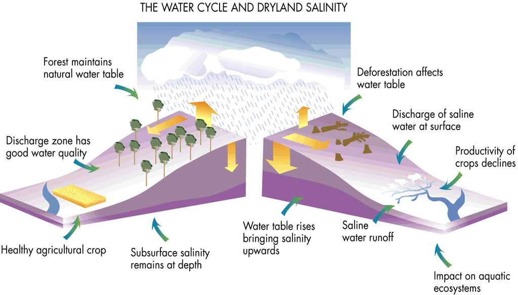
17 Impact of irrigated agriculture on surface conditions in drylands About 30% of all irrigated lands are considered to be degraded to varying degrees. Inadequate drainage and ineffective leaching of the soil, can cause problems of water logging and salinisation which are becoming increasingly frequent. A secondary and equally incidious problem is the dispersion of sodic soils leading to a reduction in soil infiltration capacity and permeability. Salt-affected lands are reflected as saline seeps in dryland agriculture and secondarily salinized irrigated lands (Tanji 1995).
 Of the almost 1 500 million ha of dryland agriculture, 32 million are salt-affected soils (2.")
18 Problem of Soil Salinity Of the current 230 million ha of irrigated land, 45 million ha are salt-affected soils (19.5 percent) Of the almost million ha of dryland agriculture, 32 million are salt-affected soils (2.1 percent) to varying degrees by human-induced processes.

19 Impact of drought and removal of vegetation on sand and dust transport It has been estimated that in the arid and semi-arid zones of the world, 24% of the cultivated land and 41% of the pasture land are affected by moderate to severe land degradation from wind erosion The world-wide total annual production of dust by deflation of soils and sediments was estimated to be 61 to 366 million tonnes. For Africa alone, more than 100 million tonnes of dust per annum is blown westward over the Atlantic.
20 Increasing frequency of sand and dust In recent years, there storms is evidence that the frequency of sandstorms is increasing. Annual frequency of strong and extremely strong sandstorms in China - 5 times in the 1950s - 8 times in the 1960s - 13 times in the 1970s - 14 times in the 1980s - 20 times in the 1990s. Every year desert encroachment caused by wind erosion buries 210,000 hectares in China ( PRC, 1994).
21 Desertification in Africa Africa accounts for 65% of the total extensive cropland degradation of the world. 485 million Africans affected by land degradation Africa burdened with $ 9.3 billion annual cost due to land degradation
22 Severity of land degradation in Mediterranean Coast (km 2 ) - Very low: 33,315 - Low: 23,042 - Medium: 74,260 - High: 119,950 Land degradation in the Mediterranean Coast The Mediterranean embraces specific zones such as the extreme northern parts of Africa, especially the coastal areas of Algeria, Egypt, Libya, Morocco and Tunisia. Main soil types here are calcisols, Gypsisols, Regosols, Arenosols and Luvisols
23 How is WMO addressing the issues of Drought and Desertification?

24 WMO - UN Specialized Agency for Weather, Climate and Water (1) National Meteorological and Hydrological Services (NMHSs) of WMO's 187 Members Global, Regional and National centres Other bodies and partnerships Strategies to monitor droughts Monthly and Seasonal weather forecasts Transfer of knowledge and technology
 Climate system, Climate variability & Climate")
25 WMO - UN Specialized Agency for Weather, Climate and Water (2) WMO's scientific & technical programmes Knowledge of the climate system Systematic & standardized observations Analysis, research and modelling Specialized observations (chemical, oceanic, ) Climate system, Climate variability & Climate change


26 WMO s s Emphasis on Drought and Agricultural drought & desertification: Desertification Issues Agricultural Meteorology Programme Hydrology and Water Resources Programme Technical Cooperation Programme
 Climate Variability (CLIVAR) project of the World Climate Research")
27 Research Bio-geophysical feedback mechanism Numerical climate models Global Energy and Water Cycle Experiment (GEWEX) Interaction of desertification and climate International Satellite Land Surface Climatology Project (ISLSCP) Climate Variability (CLIVAR) project of the World Climate Research Programme

28 Early Warning Systems for Drought WMO's GOS, GDPS and GTS for early warning Coupled climate models & high-resolution regional models Climate outlooks at multiseasonal to inter-annual time scales WMO contributes to all phases of Disaster Prevention: Prevention or mitigation; Preparedness and Early Warnings; Response & Recovery

29 Agrometeorological Applications Drought monitoring, forecasting and control Meteorological aspects of drought processes Operational use of agrometeorology Measures to alleviate the effects of droughts Assessment of the economic impacts WMO/UNEP book "Interactions of Desertification and Climate" Capacity building activities
 complementing the national efforts in water resource management WHYCOS is a vehicle for disseminating high-quality information & promoting international")
30 World Hydrological Cycle Observing System (WHYCOS) By 2025, 2/3 of world population would live in countries with medium-to-high water stress World Hydrological Cycle Observing System (WHYCOS) - regional systems (HYCOSs) complementing the national efforts in water resource management WHYCOS is a vehicle for disseminating high-quality information & promoting international collaboration

31 The Blue Planet..keep it blue..