Unmanned Aerial Systems
|
|
|
- Martina Roberts
- 5 years ago
- Views:
Transcription

1 2016 Southern Consultants Meeting Unmanned Aerial Systems How UAV s Are Helping Us Become More Profitable and Better Stewards of the Land Christian Brodbeck February 25, 2016


2 Information drives agriculture and forestry GPS sparked a geospatial data revolution in agriculture and forestry. Stand mapping Surveying Inventory Verification of services performed Guidance Yield mapping Variable rate control


3 Precision agriculture Yield monitors (with GPS) collect crop yield data during harvest. Yield maps reveal geospatial variability in crop yield. Yield maps are after-thefact and only help prepare for next year, and they don t reveal causes of variability. Maximizing potential of soil, water, and genetics means maximizing profitability for the producer.


 application")

4 Controlling variability Variable rate systems are used to control geospatial variation in crop performance. We use only what is needed. Variable rate seeding Variable rate fertilizer (or herbicide) application Variable rate irrigation Our ability to control variability is based on what we know about the source of the variation.

5 Detecting variability and developing real-time actionable information Unmanned Aerial Systems (UAS) allow rapid deployment of high resolution sensors to detect geospatial variability. Soil moisture Plant stress Moisture Nutrition Diseases Pests


6 Rotary wing aircraft are useful for visual observations of agricultural or forest operations or stand conditions


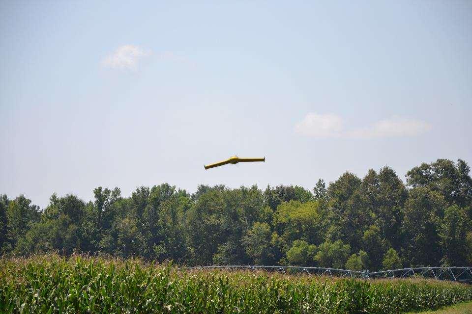
7 Fixed wing aircraft are used for longer flights over larger areas to collect crop health data

8 Flight operations are preplanned and automated

9

10
11

12

13

14


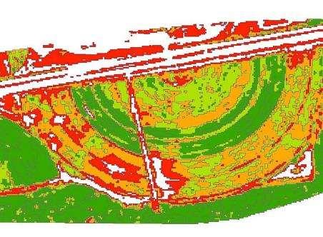
15 Detecting Mechanical Fertilizer Issues 92 acre corn field at EV Smith Research Center Flown 10 and 30 days after fertilization Data collected using a Precision Hawk (above) with an RGB camera and an ebee mounted with an NIR camera Concentric rings visible due to malfunction in fertilizer spreader Tried to address the issue, but it was too late RGB Image
 Yield loss due to fertilizer issue was17 bushels/acre, resulting in ~$3000 profit")

16 Detecting Mechanical Fertilizer Issues Mapped yield from corn harvest Compared yield from fully fertilized bands to bands that were less fertilized (right) Yield loss due to fertilizer issue was17 bushels/acre, resulting in ~$3000 profit increase for entire field. Fully Fertilized Bands Sept. 3, 2015 Yield Map Field Area Average Yield Income* ac bu/ac $/ac Partially Fertilized $ Fully Fertilized $ Difference 17 $ *Assumes price of corn at $3.50/bushel

17 RGB RGB vs. NIR vs. Multi-spectral NIR Multi-Spectral Courtesy of Sensefly Courtesy of Agribotix


18 NDVI Image Prescription Map


19 NDVI From Image UAS To NDVI Application Map To Sprayer To Prescription Map
 must be filed for all UAS")
20 FAA Regulations Public COA Register UAS Operation is for a specific activity Apply for a COA May or may not have to be a licensed pilot A Notice to Airmen (NOTAM) must be filed for all UAS activity.

21 FAA Regulations 333 Exemption Apply for 333 Exemption Granted for one or more UAS types Exemption allows user to: Fly anywhere in USA Flight height under 200-ft 2-5nm from an airport Licensed pilot Must submit NOTAM before flight

22 FAA Regulations Proposed Rules UAS Operators must: Be 17 years old Pass FAA approved aeronautical knowledge test Must maintain Visual Line of Sight UAS may not operate over any persons not directly involved with flight Maximum speed of 100mph Maximum altitude of 500 feet above ground level


23 UAS Regulations What is new?


24 UAS Regulations What is new? Hobbyist UAS Registration


25 UAS Regulations What is new?

26 Actionable information UAS allow collection of real-time actionable information to help the landowner make better management decisions. More precise application of: Water Fertilizer Herbicide Pesticide Using precision agriculture techniques allowed Alabama farmers to reduce fertilizer applications by 10%; saving $25 million per year.


27 Profitability & Stewardship Technology innovation will continue to advance forestry, agriculture, and natural resource management. UAVs are another tool to help us know the land and make better management decisions.


28 Thank You FAA Approved Christian Brodbeck, P.E. (334)