|
|
|
- Damian Morrison
- 6 years ago
- Views:
Transcription
1 FP7- SPA : Stimulating development of downstream services and service evolution. Contract N : A downstream service to support agro-production, planning and policy Boschetti.m@irea.cnr.it


2 PROJECT FRAMEWORK FP7 Space project to create a downstream service What is an FP7 project Provide added value information to agro sector exploiting availabe space data and Europena core services 26/05/2017 2

3 OVERALL PRESENTATION OF THE PROJECT FP7-SPACE CALL - Contract N : REA Project officer Ines Marin-Moreno


4 PROJECT FRAMEWORK Why ERMES: provide information to agro-sector FP7-SPACE ERMES aims to develop a prototype of downstream service dedicated to rice sector based on assimilation of EO and in situ data within crop yield modelling. The objective of this service, targeted to European needs, is to: contribute to the regional authorities in the implementation of agro-environmental policies; provide independent reliable information to the agro-business sector. support farming activities for sustainable management practices; The long term goal is to extend and adapt the service to Asian and African markets, in order to boost European competitiveness and contribute to a sustainable development.


5 The project/services Concept 26/05/

6 PROJECT FRAMEWORK: WHERE WE ARE AND WHO WE SERVE! Study areas Europe Italy Spain Greece West Africa Gambia Senegal ERMES user Allianz Re Regulatory Board of Denominación de Origen Arroz de Valencia (C.R.D.O.) DG Agricoltura Regione Lombardia (RL) Cereal Institute of the Hellenic Agricultural Organisation (DEMETER) Ministry of Agriculture of Gambia JRS MARS unit ILVIA Local farmers Regional Plant Health Service ENTE RISI (ER) Cattolica Assicurazioni Lomellina district & single Farmers Agricultural cooperative Chalasytra B Thessaloniki KANAKAS BROS Ltd Plastiras Familiy (farmer/service provider) ECODEVELOPMENT_SA AFRICARICE (Senegal River) Since project proposal New USers IPLA- Regione Piemente AGRICULTURAL COOPERATIVE AGIOS ATHANASIOS

7 SCIENTIFIC AND TECHNICAL ASPECT
 customized (ground) information to (from) different")
 Smart app.")

 satellite observations, ii)")
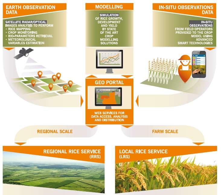
8 SCIENTIFIC AND TECHNICAL ASPECT Innovative approach Provide (receive) customized (ground) information to (from) different END-USERS, and disseminate it by SMART technologies (web 2.0) Smart app. Geoportal Synergic use of SAR and Optical data, from existing EO satellites and forthcoming ESA Sentinel missions, to derive specific products Satellite data Develop value added Agro-information by assimilating i) satellite observations, ii) in situ measurements and iii) Copernicus core services in crop models WARM model 8


")


9 ERMES: a prototype of downstream service Regional rice monitoring system in Europe (Italy, Spain and Greece)* EO processing chain: automatic procedure to derive geo products (Crop mapping, Meteo maps, LAI, Phenology ) as spatialized inputs for the model ERMES products Geo-processing 2 by 2 km Simulation «Grid» Modelling solution: customization of WARM rice model, for ERMES regional applications, to simulate rice growth processes on a 2x2 km grid over study areas (Italy, Spain, Greece and Gambia) Risk WARM MODEL Yield indicators Yield forecast Statistical analysis Outputs generation and deploy: provide via dedicated GEOPORTAL risk alert and yield estimation
 @ District scale Local Rice Service (LRS) @ Farm scale Provide to authorities (institution with monitoring mandate)")
 high level information on yield variability, risk")
10 ERMES services A system to monitor spatial variability of rice production at regional (district) and local scale Regional Rice Service District scale Local Rice Service Farm scale Provide to authorities (institution with monitoring mandate) customized agro-monitoring system devoted to regional yield estimates and risk alarming. provide to the private sector (farmers, cooperative, agro-consulting, etc) high level information on yield variability, risk alert and crop damage assessment at farm scale 10
11 SERVICE DEMONSTRATION RRS

12 SERVICE APPLICATION AT REGIONAL SCALE REGIONAL RICE SERVICE PRODUCTS GENERATION AND DEPLOYMENT Interface of ERMES Regional Geoportal and examples of provided information 26/05/

 Periodic Maps of flooding conditions NRT")

13 SERVICE APPLICATION AT REGIONAL SCALE REGIONAL RICE SERVICE PRODUCTS GENERATION AND DEPLOYMENT Rice maps ; Flooding Maps (WP 5) (EP_R1) WP5 Rice crop maps (30 m resolution) Periodic Maps of flooding conditions NRT estimation of rice cultivated area Interannual variations in rice area Spatio-temporal changes in irrigation schemes 26/05/
 (EP_R2)")

14 SERVICE APPLICATION AT REGIONAL SCALE REGIONAL RICE SERVICE PRODUCTS GENERATION AND DEPLOYMENT Phenology maps (WP 5) (EP_R2) WP5 Sowing and Flowering dates maps (2x2 km) Identification of key phenological stages and anomalies Inputs for regional modelling 26/05/


15 SERVICE APPLICATION AT REGIONAL SCALE REGIONAL RICE SERVICE PRODUCTS GENERATION AND DEPLOYMENT Leaf Area Index maps (WP 5) (EP_R3) WP5 Decadal maps from MODIS/PROBA-V (2x2 km) Anomalies in crop growth Inputs for regional modelling 26/05/
 Anomalies in weather conditions; Inputs for regional modelling 26/05/2017")
16 SERVICE APPLICATION AT REGIONAL SCALE REGIONAL RICE SERVICE PRODUCTS GENERATION AND DEPLOYMENT Meteorological Maps and Forecasts (WP 5) (EP_R4) WP5 Daily maps of P, Tmax, Tmin, Precipitation, Humidity, Wind Speed, radiation (2x2 km) Anomalies in weather conditions; Inputs for regional modelling 26/05/


17 SERVICE APPLICATION AT REGIONAL SCALE REGIONAL RICE SERVICE PRODUCTS GENERATION AND DEPLOYMENT Potential Risk of Rice Blast Infection (WP 6) (EI_R3) Daily risk maps Modelling Results Uses Meteo, Phenology and LAI maps as inputs! WP6 Number of High Risk Days - Spain Forecasting high-risk periods Qualitative analysis on impact on yield 26/05/


18 ERMES: biotic risk Daily values and 6-days forecasts of risks for blast infection and spikelet sterility («cold-spells») A Trip from Mountains to Valley: Copernicus satellites as sentinels" of environmental and economical changes 20/10/


; One release for Spain and Greece Yield Forecast")
19 SERVICE APPLICATION AT REGIONAL SCALE REGIONAL RICE SERVICE HIGH-END APPLICATIONS Yield Forecast Bulletins Agro-monitoring bullettins, analyzing the on-going season and providing yield forecasts for selected varieties and rice districts ERMES Meteo, Phenology and LAI maps used as inputs in regional modelling solution Statistical postprocessing of modelling outputs and official statistics Two releases in Italy for ENR (at Flowering and Harvesting); One release for Spain and Greece Yield Forecast Bulletins 26/05/

20 SERVICE APPLICATION AT REGIONAL SCALE REGIONAL RICE SERVICE HIGH-END APPLICATIONS Blast Risk Bullettins Automatic generation from ERMES modelling outputs Aggregation at municipality level and weekly time step Daily deployment of rice blast risk bullettins on website of Plant Health Service of Lombardy Region Example of Blast Risk Bulletins


21 SERVICE APPLICATION AT REGIONAL SCALE REGIONAL RICE SERVICE HIGH-END APPLICATIONS Phenological development analysis Comparison of on-going season with LTA data Highlights of anomalies Data exploited by JRS-MARS to issue their 2016 agromonitoring bulletins NRT comparison of current vs. previous seasons
22 SERVICE DEMONSTRATION LRS
23 SERVICE APPLICATION AT LOCAL SCALE LOCAL RICE SERVICE PRODUCTS GENERATION AND DEPLOYMENT Interface of ERMES Local Geoportal and examples of provided information 26/05/


24 SERVICE APPLICATION AT LOCAL SCALE LOCAL RICE SERVICE PRODUCTS GENERATION AND DEPLOYMENT AgriNotebook smart app WP7 Information collected by farmers/field operators retrievable in web interface and used as input for crop modelling 26/05/

25 SERVICE APPLICATION AT LOCAL SCALE LOCAL RICE SERVICE PRODUCTS GENERATION AND DEPLOYMENT Constant pattern maps (EP_L2) WP5 Based on the analysis of archive satellite images Highlight intrinsic variability of single rice parcels, causing constant yield differences on different years 26/05/
 Highlight problems related to bad germination/other early season problems 26/05/2017")
26 SERVICE APPLICATION AT LOCAL SCALE LOCAL RICE SERVICE PRODUCTS GENERATION AND DEPLOYMENT Seasonal pattern maps (EP_L3; EI_L7) WP5 Based on the analysis of satellite Images acquired in critical moments of the season «Early» season High-Resolution SAR (CSK 3m) Highlight problems related to bad germination/other early season problems 26/05/
 WP5 Based on")
 Variability")

27 SERVICE APPLICATION AT LOCAL SCALE LOCAL RICE SERVICE PRODUCTS GENERATION AND DEPLOYMENT Seasonal pattern maps (EP_L2) WP5 Based on the analysis of satellite Images acquired in critical moments of the season «Late» season High-Resolution optical (RapidEye) Variability map 04/07/2016 Classification 04/07/2016 Highlight variability in crop biomass / nutritional status Below Average On Average Above Average 26/05/

28 SERVICE APPLICATION AT LOCAL SCALE LOCAL RICE SERVICE PRODUCTS GENERATION AND DEPLOYMENT LAI maps (EP_R4 EP_L4) WP5 Dense time series of HR LAI maps from OLI/Sentinel-2 Effect of Akiochi Attack Wrong herbicide treatment Highlight effect of diseases/other damages Inputs for local modelling 26/05/
29 Growth Stage SERVICE APPLICATION AT LOCAL SCALE LOCAL RICE SERVICE PRODUCTS GENERATION AND DEPLOYMENT Local Biotic risks; Development stage (EI_Lx) WP6 Model outputs for each field can be visualized in the ERMES GeoPortal and are used to issue mail alerts 1 st FERTILIZATION 2 nd FERTILIZATION Mail alerts can be sent upon reaching the most suitable moments for nitrogen ferilization 26/05/
30 Risk Level (%) SERVICE APPLICATION AT LOCAL SCALE LOCAL RICE SERVICE PRODUCTS GENERATION AND DEPLOYMENT Local Biotic risks; Development stage (EI_Lx) WP6 Model outputs for each field can be visualized in the ERMES GeoPortal and are used to issue mail alerts High Risk! Potential risk of Blast Infection Mail alerts can be sent upon detection of high-risk periods for rice blast infection 26/05/


31 SERVICE APPLICATION AT LOCAL SCALE LOCAL RICE SERVICE EXPLOITATION OF PRODUCTS/SERVICES FOR HIGH-END APPLICATIONS Support for Variable Rate Fertilization ERMES variability maps (constant and seasonal) were transformed in prescription maps to be used as inputs for variable rate fertilization techniques (Precision Agriculture) Support for pre-sowing and top-dressing fertilization Italy In 2015 and 2016 several rice fields were managed with different levels of Nitrogen fertilization based on ERMES variability maps Constant variability map Seasonal variability map 14 July 2015 and 2016 experiments demonstrated that managing fields based on prescription maps generated from ERMES products allows a more rational use of fertilizers, allowing to achieve a better homogeneity in final yield and/or a reduction of fertilization costs. Pre-sowing prescription map Top-dressing prescription map 50 Units /ha 33 Unità /ha 27 Units /ha 30 Units /ha 33 Units /ha From Constant/Seasonal Patterns to prescription maps 26/05/
Tecnologie ICT per la Gestione dell Ambiente. Il progetto FP7 ERMES: An Earth observation Model based RicE information Service; Mirco Boschetti
 Autore dell intervento Tecnologie ICT per la Gestione dell Ambiente Il progetto FP7 ERMES: An Earth observation Model based RicE information Service; Mirco Boschetti Monica Pepe, Lorenzo Busetto, Gabriele
 FP7- SPA.2013.1.1-06: Stimulating development of downstream services and service evolution. Contract N : 606983 A downstream service to support agro-production, planning and policy http://www.ermes-fp7space.eu/
A downstream service to support agro production, planning and policy. FP7 SPACE CALL Contract N :
 A downstream service to support agro production, planning and policy FP7 SPACE 2013 1 CALL Contract N : 606983 Project coordinator Mirco Boschetti CNR IREA PROJECT FRAMEWORK Who is ERMES (H)ermes (/ˈhɜrmiːz/;
WP8 - SCIENTIFIC AND TECHNICAL VALIDATION OF PRODUCT
 WP8 - SCIENTIFIC AND TECHNICAL VALIDATION OF PRODUCT AND SERVICES Speaker: Monica Pepe (CNR-IREA) Task 8.1 Leader: Ioannis Gitas (AUTH) Task 8.2 Leader: Manuel Campos-Taberner (UVEG) Task 8.3 Leader: Ignacio
 A downstream service to support agro-production, planning and policy FP7-SPACE-2013-1- CALL Contract N : 606983 http://www.ermes-fp7space.eu/ ERMES 1st Annual Meeting 26-27/03/2015 - Valencia End-Users
D11.10 ERMES Italian open days
 FP7-SPACE 2013-1 - Grant n 606983 D11.10 ERMES Italian open days Task Task 11.2: ERMES involvement and promotion to users communities Work Package WP11: Dissemination and promotion Author(s) Deliverable
Summary of the socio-economic impact of Copernicus in the EU
 Summary of the socio-economic impact of Copernicus in the EU ESA Since the entry into service of Copernicus first satellite, Sentinel-1A, in 2014, the impacts of the programme are witnessed beyond the
WHEN SPACE MEETS AGRICULTURE
 WHEN SPACE MEETS AGRICULTURE Image from ESA Sentinel 14-15 November 2016 Matera, Italy Join the conversation #WSMA16 What can Copernicus do for farmers and for the European Agricultural Policy Catharina
Rice Monitoring in Europe
 JRC 66856 - ISSN 1831-9793 EUR 24736 EN -2011 Rice Monitoring in Europe Second part of the season Despite some downward revisions in the final figures the average yield potential remains satisfactory Highlights
Crop Modelling & Yield Forecasting
 Crop Modelling & Yield Forecasting AGRICAB FINAL MEETING 23-24/03/2015 Hendrik Boogaard Alterra, WUR hendrik.boogaard@wur.nl WP31 Crop Production Systems Agricultural statistics Agro-meteorological modeling
The European Commission s science and knowledge service. Joint Research Centre
 The European Commission s science and knowledge service Joint Research Centre JRC MARS Crops yield forecasts: method and 2018 forecasts Bettina Baruth Brussels 11/07/2018 Table of content Mars Crop Yield
The good yield potential depicted for the main EU-27 producer countries keeps total production above the long term average
 JRC 61870 - ISSN 1725-5813 - EUR 23298 EN -2010 First part of the season The good yield potential depicted for the main EU-27 producer countries keeps total production above the long term average Highlights
Collaboration of Space Research Institute NASU-SSAU with EC JRC on satellite monitoring for food security: background and prospects
 Collaboration of Space Research Institute NASU-SSAU with EC JRC on satellite monitoring for food security: background and prospects Prof. Nataliia Kussul 1 Space Research Institute NASU-SSAU, Ukraine Context
Climate research initiatives in Ethiopian Institute of Agricultural Research
 Climate research initiatives in Ethiopian Institute of Agricultural Research Andualem Shimeles Ethiopian Institute of Agricultural Research Andualem.Shimeles@eiar.gov.et NASA IDS: Seasonal Prediction of
H2020 SENSAGRI project: developing prototypes for new Copernicus services for agriculture
 GEOINT for Environmental Compliance Assurance in rural areas/agriculture H2020 SENSAGRI project: developing prototypes for new Copernicus services for agriculture Antonio Ruiz Verdú University of Valencia
Joint Experiment for Crop Assessment and Monitoring GEOGLAM Implementation Meeting Washington D.C. February 21, 2013
 Joint Experiment for Crop Assessment and Monitoring GEOGLAM Implementation Meeting Washington D.C. February 21, 2013 Ian Jarvis JECAM Sub-Task Lead Earth Observation Service, Agriculture and Agri-Food
Monitoring Agriculture with Remote Sensing (MARS) A focus on agricultural user requirements. Guido Lemoine European Commission, JRC, Ispra, Italy
 A focus on agricultural user requirements. Guido Lemoine European Commission, JRC, Ispra, Italy") Monitoring Agriculture with Remote Sensing (MARS) A focus on agricultural user requirements Guido Lemoine European Commission, JRC, Ispra, Italy www.jrc.ec.europa.eu Serving society Stimulating innovation
Monitoring Agriculture with Remote Sensing (MARS) A focus on agricultural user requirements Guido Lemoine European Commission, JRC, Ispra, Italy www.jrc.ec.europa.eu Serving society Stimulating innovation
Use of Sentinel 2 for agricultural operational applications at farm level - Talking Fields
 Use of Sentinel 2 for agricultural operational applications at farm level - Talking Fields Dr. Heike Bach Vista - Remote Sensing in Geosciences GmbH VISTA 2016 www.vista-geo.de No. 1 Vista Remote Sensing
geoland GEOLAND Overview of Interacting parts and future plans Integrated GMES Project on Landcover and Vegetation
 Integrated GMES Project on Landcover and Vegetation GEOLAND Overview of Interacting parts and future plans Marc Leroy Jean-Christophe Calvet Marek Tinz Kees van Diepen Etienne Bartholomé Co-funded by the
Service: status & evolution
 The Copernicus Global Land Service: status & evolution R. Lacaze HYGEOS on behalf the GIO - Global Land consortium What is Copernicus? The European system for monitoring i the Earth The European response
eo4all The European EO Services Industry
 eo4all @ESA, Pío XI Glacier, Chile @Benjamin Grant/Google Earth/Digital Globe Man must rise above Earth to the top of the atmosphere & beyond, for only then Industry will he fully understand the world
Rice Monitoring from Space?
 Rice Monitoring from Space? Thuy Le Toan CESBIO, Toulouse, France The GEORICE Project Towards Operational Rice Monitoring Benjamin Koetz Thuy Le Toan, Phan Thi Hoa Alexandre Bouvet Lam Dao Nguyen, VNSC
ITALIAN AGRICULTURAL PRODUCTION AND THE HEAT WAVE DURING SUMMER Luigi Perini 1 and M. Carmen Beltrano Ministry of Agriculture, Rome, Italy
 P1.41 ITALIAN AGRICULTURAL PRODUCTION AND THE HEAT WAVE DURING SUMMER 23 Luigi Perini 1 and M. Carmen Beltrano Ministry of Agriculture, Rome, Italy 1. INTRODUCTION Mediterranean climate is usually defined
Sentinel-2 Agriculture project : Preparing Sentinel2 exploitation for agriculture monitoring
 Sentinel-2 Agriculture project : Preparing Sentinel2 exploitation for agriculture monitoring Defourny Pierre, Bontemps Sophie, CaraCozmin, Dedieu Gerard, Hagolle Olivier, Inglada Jordi, Thierry Rabaute,
Introduction to yield forecasting with CST
 Introduction to yield forecasting with CST H. Kerdiles (JRC), H. Boogaard & S. Hoek (Alterra) Harare, Zimbabwe 26 Oct 2016 Yield variability: can you rank the maize fields according to their yield? Same
Asia-RiCE 2016 Implementation Report
 Asia-RiCE 2016 Implementation Report Asia-RiCE has been organised to develop the rice crop estimation and monitoring component for the GEO Global Agricultural Monitoring (GEOGLAM) initiative. GEOGLAM aims
Guided by WMO-134 ( Guide to Agricultural Meteorological Practices (GAMP) 2007 completely revised version) Sistana SCADA Systems Ltd.
 2007 completely revised version) Sistana SCADA Systems Ltd.") Agricultural Decision Support System Guided by WMO-134 ( Guide to Agricultural Meteorological Practices (GAMP) 2007 completely revised version) Sistana SCADA Systems Ltd. Agricultural Decision Support
Agricultural Decision Support System Guided by WMO-134 ( Guide to Agricultural Meteorological Practices (GAMP) 2007 completely revised version) Sistana SCADA Systems Ltd. Agricultural Decision Support
Estimation of the extreme meteorological and hydrological conditions in Slovenia in the future
 International Workshop on Climate Change, Budapest, 6 8 June 2016 REPUBLIC OF SLOVENIA MINISTRY OF THE ENVIRONMENT AND SPATIAL PLANNING SLOVENIAN ENVIRONMENT AGENCY Estimation of the extreme meteorological
Sentinels for Agriculture Global, Operational, Open, Reliable
 Sentinels for Agriculture Global, Operational, Open, Reliable Benjamin Koetz European Space Agency Earth Observation Directorate ESA UNCLASSIFIED - For Official Use Sentinel-2B Launch Tonight, 7 th of
Advanced Ultraviolet Radiation and Ozone Retrieval for Applications
 EUROPEAN COMMISSION Advanced Ultraviolet Radiation and Ozone Retrieval for Applications Jean-Christopher Lambert (IASB-BIRA) and the AURORA Project Team ISSeP NCP Wallonie Skywin GT EO 20 September 2016
2. Outline business case (why this piece of work?)
") TOR Reference.: 2016/14 Authors: Enrico Zini, Giuseppe Sgorbati (ARPA Lombardia Italy) Version: 2.0 Date: 10/11/2015 TERMS OF REFERENCE FOR WORK UNDER THE AUSPICES OF IMPEL 1. Work type and title 1.1 Identify
TOR Reference.: 2016/14 Authors: Enrico Zini, Giuseppe Sgorbati (ARPA Lombardia Italy) Version: 2.0 Date: 10/11/2015 TERMS OF REFERENCE FOR WORK UNDER THE AUSPICES OF IMPEL 1. Work type and title 1.1 Identify
OF EXTENSIVE CROPS IN SPAIN sigagroasesor Project. Antonio Mestre AEMET
 CUSTOMIZED ADVANCED GIS ADVISORY TOOLS FOR THE SUSTAINABLE MANAGEMENT OF EXTENSIVE CROPS CUSTOMIZED ADVANCED GIS ADVISORY TOOLS FOR THE SUSTAINABLE MANAGEMENT OF EXTENSIVE CROPS IN SPAIN sigagroasesor
GEOGLAM international cooperation activities
 GEOGLAM international cooperation activities Chris Justice Center for Global Agricultural Monitoring and Research Dept. of Geographical Sciences University of Maryland GEO: an International Coordinating
Crop monitoring and yield forecasting MARS activities in South America
 Crop monitoring and yield forecasting MARS activities in South America Raúl LÓPEZ LOZANO European Commission, Joint Research Centre GLOBCAST dissemination event Conference Centre Albert Borschette Brussels,
Examples of successful applications of weather and climate products for agriculture in Europe
 Examples of successful applications of weather and climate products for agriculture in Europe Philippe FRAYSSINET Météo-France Toowoomba,, Queensland, Australia 18-21 May 2009 Plan Introduction Context
CGMS-Maroc: National System for Agrometeorological monitoring
 CGMS-Maroc: National System for Agrometeorological monitoring Mouanis LAHLOU Hassan II Institute of Agronomy and Veterinary Medicine On behalf : Balagui R., Arrach R., El Hairech T., Ajerame M.M., Content
Advanced Ultraviolet Radiation and Ozone Retrieval for Applications
 EUROPEAN COMMISSION Advanced Ultraviolet Radiation and Ozone Retrieval for Applications Jean-Christopher Lambert (IASB-BIRA) and the AURORA Project Team ISSeP NCP Wallonie Skywin GT EO 20 Septembre 2016
Agriculture at the crossroads of IIoT and HPC
 Agriculture at the crossroads of IIoT and HPC when real-time observation meets simulation to improve plant proteins and reduce nitrate pollution Marion CARRIER Context : increasing expectations and challenges
Requirements from agriculture applications
 Requirements from agriculture applications Nadine Gobron On behalf Andrea Toreti & MARS colleagues MAIN ACTIVITIES Crop monitoring and yield forecasting in EU and neighbouring countries since 1992 Crop
CRYOLAND Copernicus Snow and Land Ice Service. SUMMARY OF ACHIEVEMENTS IN 1st, 2nd, 3rd and 4th PERIOD
 CRYOLAND Copernicus Snow and Land Ice Service SUMMARY OF ACHIEVEMENTS IN 1st, 2nd, 3rd and 4th PERIOD Author: Thomas Nagler / ENVEO, Project Coordinator USER REQUIREMENTS AND USER SUPPORT, PRODUCT AND
From Image to Information
 From Image to Information Using ICT and Earth Observation to support food security Workshop on innovations in food and agriculture system: Policies to foster productive and sustainable solutions OECD 26.
GMES and AFRICA
 Global Monitoring for Environment and Security Mauro.Facchini@ec.europa.eu GMES and AFRICA What is GMES? European response to global needs to manage the environment, understand and mitigate the effects
Drought monitoring and early warning in the Sahel : The AGRHYMET experience
 Drought monitoring and early warning in the Sahel : The AGRHYMET experience Presentation at the World Conference on Disaster Reduction Kobe, Japan, 18 22 January, 2005 by Dr Seydou B. TRAORE Agrometeorologist
WATER EXTREMES MANAGEMENT. Water extremes mapping with EO: the FloodHub service of the BEYOND Center of Excellence. Alexia Tsouni, NOA, Greece
 WATER EXTREMES MANAGEMENT Water extremes mapping with EO: the FloodHub service Alexia Tsouni, NOA, Greece Relevant needs registered in D2.5 User Need Analysis Report I FLOODS Serbia, Romania, Bulgaria:
CAN LOW COST, CONSUMER UAV'S MAP USEFUL AGRONOMIC CHARACTERISTICS?
 Wilson, J.A., 2017. Can low cost, consumer UAV s map useful agronomic characteristics? In: Science and policy: nutrient management challenges for the next generation. (Eds L. D. Currie and M. J. Hedley).
2.2 Methods 2 DATA SET AND METHODS USED
 COMBINING CROP MODEL AND REMOTE SENSING DATA AT HIGH RESOLUTION FOR THE ASSESSMENT OF RICE AGRICULTURAL PRACTICES IN THE SOUTH- EASTERN FRANCE (TAKE 5 EXPERIMENT SPOT4-SPOT5) Courault D (1), Ruget F (1),
Water and Life in the Universe ASI Activities and Achievements
 Water and Life in the ASI Activities and Achievements COSPAR Symposium Prof. Roberto Battiston, ASI President Foz do Iguacu, November 9, 2015 Water Economics Water Economics The Setting Water is a natural
Sentinel-2 for agriculture and land surface monitoring from field level to national scale
 Sentinel-2 for agriculture and land surface monitoring from field level to national scale The on-going BELCAM, Sen2-Agri and LifeWatch experiences C. Delloye, S. Bontemps, N. Bellemans, J. Radoux, F. Hawotte,
Review. of the application of modern information technologies in the agricultural management systems. S.Korsakova
 Review of the application of modern information technologies in the agricultural management systems S.Korsakova REVIEW OF MODERN INFORMATION TECHNOLOGIES APPLIED INAGRICULTURAL MANAGEMENT SYSTEMS The USA,
Reinhard Blasi EGNOS and Galileo in Agriculture. European GNSS Agency Market Development
 Reinhard Blasi EGNOS and Galileo in Agriculture European GNSS Agency Market Development Agenda 2 European GNSS Agency GSA EGNOS and Galileo in Agriculture Main Applications in Precision Agriculture Differences
geoland HALO Workshop Issue I.1.00 Observatory of Natural Carbon fluxes Jean-Christophe Calvet and the geoland / ONC Team
 Observatory of Natural Carbon fluxes HALO Workshop Issue I.1.00 Jean-Christophe Calvet and the / ONC Team November 2004 ONC overview ONC tools ONC implementation ONC first results Conclusions November
The System for Providing Farmers with Agro- Meteorological Information on the Base of Web-Technology Prof. Alexander Kleschenko
 The System for Providing Farmers with Agro- Meteorological Information on the Base of Web-Technology Prof. Alexander Kleschenko Russian National Institute on Agricultural Meteorology 82, Lenin street,
Rice crop monitoring using EO data in the Mekong Delta, Vietnam
 The 10th GEOSS Asia-Pacific Symposium WG5: Agriculture and Food Security Hanoi, 18-20 th, Sep. 2017 Rice crop monitoring using EO data in the Mekong Delta, Vietnam Lam Dao Nguyen, Hoang Phi Phung, Dang
DEVELOPMENT OF A DECISION SUPPORT SYSTEM FOR NATURAL DAMAGE ASSESSMENT BASED ON REMOTE SENSING AND BIO-PHYSICAL MODELS
 DEVELOPMENT OF A DECISION SUPPORT SYSTEM FOR NATURAL DAMAGE ASSESSMENT BASED ON REMOTE SENSING AND BIO-PHYSICAL MODELS M.A. Sharifi a*, W.G.M. Bastiaanssen b, S.J. Zwart b a ITC, P.O. Box 6, 7500 AA, Enschede,
Seasonal Monitoring in DPRK 2014
 Seasonal Monitoring in DPRK 2014 Lower crop production expected compared to 2013 Anne Schucknecht, Francois Kayitakire, Hervé Kerdiles September 2014 Absolute NDVI anomalies between the current year (2014)
New Capabilities in Earth Observation for Agriculture
 New Capabilities in Earth Observation for Agriculture Training course on the use of satellite products for drought monitoring and agro-meteorological applications Budapest, 25 April 2017 Espen Volden,
FAO-Rome as a form of technical support to the Global Information and Early Warning System (GIEWS)
") pixabay/17 Country-Level ASIS: an agriculture drought monitoring system Background The Food and Agriculture Organization of United Nations (FAO) has developed an agricultural drought monitoring system
pixabay/17 Country-Level ASIS: an agriculture drought monitoring system Background The Food and Agriculture Organization of United Nations (FAO) has developed an agricultural drought monitoring system
Evaluation of benefits and constraints for the use of Sentinel-2 for agricultural monitoring
 23/05/2014 Evaluation of benefits and constraints for the use of Sentinel-2 for agricultural monitoring Isabelle Piccard, Herman Eerens, Kris Nackaerts, Sven Gilliams, Lieven Bydekerke Sentinel-2 for Science
Potential of Sentinel-2 Type Observation
 MULTISOURCE EO DATA FOR THE OPTIMAL AGRICULTURAL DRAINAGE WATER MANAGEMENT IN THE SEMI-ARID AREA OF DOUKKALA (WESTERN MOROCCO): Potential of Sentinel-2 Type Observation Kamal Labbassi 1 Nadia Akdim, Silvia
The GEO Global Agricultural Monitoring (GEOGLAM) Initiative
 Initiative") The GEO Global Agricultural Monitoring (GEOGLAM) Initiative Chris Justice GEOGLAM Global Co-Lead The Center for Agricultural Monitoring Research, Department of Geographical Sciences, GEOGLAM Launched by
The GEO Global Agricultural Monitoring (GEOGLAM) Initiative Chris Justice GEOGLAM Global Co-Lead The Center for Agricultural Monitoring Research, Department of Geographical Sciences, GEOGLAM Launched by
Agrobiodiversity and agroecology: state of the art and opportunities in EU policy
 Agrobiodiversity and agroecology: state of the art and opportunities in EU policy Maria Luisa Paracchini 1 and Marco Bertaglia 2 1 Food Security Unit 2 Land Resources Unit European Commission, Joint Research
Copernicus Global Land Service possible downstream services in Agriculture. Lieven Bydekerke, Programme Manager Remote Sensing Applications
 Copernicus Global Land Service possible downstream services in Agriculture Lieven Bydekerke, Programme Manager Remote Sensing Applications Outline» Challenges in global Agriculture» Remote sensing & agriculture»
Irrigation Advisory Plan of Campania Region
 Irrigation Advisory Plan of Campania Region Amedeo D Antonio Regione Campania - ITALY Agriculture Assessorship Carlo De Michele Ariespace srl, Spin-Off Company University of Naples - ITALY agriculture
JECAM - Joint Experiment for Crop Assessment and Monitoring Recent progress with SAR/Optical Inter-Comparison Projects Ian Jarvis Co-lead of JECAM
 JECAM - Joint Experiment for Crop Assessment and Monitoring Recent progress with SAR/Optical Inter-Comparison Projects Ian Jarvis Co-lead of JECAM Science and Technology Branch, Agriculture and Agri-Food
User Awareness & Training: LAND. Tallinn, Estonia 9 th / 10 th April 2014 GAF AG
 User Awareness & Training: LAND Tallinn, Estonia 9 th / 10 th April 2014 GAF AG Day 2 - Contents LAND (1) General Introduction to EO and the COPERNICUS Sentinel Programme Overview of COPERNICUS/GMES LAND
Ера "великих даних" та інноваційні проекти в супутниковому моніторингу
 Ера "великих даних" та інноваційні проекти в супутниковому моніторингу Проф. д.т.н. Куссуль Наталія Миколаївна, к.т.н. Колотій А.В., М.С. Лавренюк Інститут космічних досліджень НАН України та ДКА України
GMES Global Monitoring for Environment and Security
 GMES Global Monitoring for Environment and Security Mikko Strahlendorff Programme manager at GMES Bureau DG Enterprise & Industry - Euu ropp eaa n C omm mii sss ionn Need for information Need for information
THE TIGER INITIATIVE. Looking After Water in Africa
 THE TIGER INITIATIVE Looking After Water in Africa In 2002, responding to the urgent need for action in Africa stressed by the Johannesburg World Summit on Sustainable Development (WSSD), the European
Drought Monitoring and Early Warning in West Africa. At the AGRHYMET Regional Center. By Seydou B. TRAORE,
 Drought Monitoring and Early Warning in West Africa At the AGRHYMET Regional Center By Seydou B. TRAORE, agrometeorologist 1 Outline Introduction Background information about AGRHYMET The Early Warning
WMO Technical Conference
 Moving from climate to impact forecasts Delivering Climate Services for Decision Making J.P. Céron - Météo-France Jean-Pierre.Ceron@meteo.fr and contribution from Euporias project (thanks to Carlo, Pete
Impact of extreme events on crop production under climate change in Belgium
 24/05/2011 Impact of extreme events on crop production under climate change in Belgium Dr.ir. Anne Gobin COST 734 Importance of climate & weather impacts on crop production» With climate change extreme
IMPACT ANALYSIS: RESULTS FROM TEST SITES. University of Bologna (UNIBO)
") Workshop on Precise Irrigation: The FIGARO Project Bologna 19 July, 2016 IMPACT ANALYSIS: RESULTS FROM TEST SITES Francesco Galioto, Meri Raggi, Parthena Chatzinikolaou, Davide Viaggi University of Bologna
Workshop on Precise Irrigation: The FIGARO Project Bologna 19 July, 2016 IMPACT ANALYSIS: RESULTS FROM TEST SITES Francesco Galioto, Meri Raggi, Parthena Chatzinikolaou, Davide Viaggi University of Bologna
Future Climate Observation Activities of ESA
 Future Climate Observation Activities of ESA GCOS Conference 2016 Amsterdam, 2 March 2016 Prof. Volker Liebig, ESA Director of Earth Observation Programmes COP-21 Global average temperature increase to
Operational products for crop monitoring. Hervé Kerdiles, JRC MARS
 Operational products for crop monitoring Hervé Kerdiles, JRC MARS Outline Meteo products Rainfall, temperature, global radiation, ETa, snow depth Biomass indicators & crop yield prediction NDVI & other
MCYFS The agrometeorological system of the EC: present and future
 Institute for Protection and Security of the Citizen Wageningen 19 October 2007 1 WIMEK workshop on Earth Observation and crop growth modeling 1 MCYFS The agrometeorological system of the EC: present and
DMC 22m Sensors for Supertemporal Land Cover Monitoring. Gary Holmes DMC International Imaging Ltd June 2014
 DMC 22m Sensors for Supertemporal Land Cover Monitoring Gary Holmes DMC International Imaging Ltd June 2014 DMC 2 nd Generation Satellites UK-DMC2 and Deimos-1 launched 29 th July 2009 650km swath width
Michel F. Massart DG ENTR - European Commission
 Michel F. Massart DG ENTR - European Commission COPERNICUS Program COPERNICUS Global Land component COPERNICUS Program Copernicus seen from the Regulation (GMES) Global Monitoring for Environment and Security
G l o b a l L a n d S e r v i c e
 G l o b a l L a n d S e r v i c e Mark Dowell European Commission JRC mark.dowell@ec.europa.eu http://land.copernicus.eu/global 2 M a n d a t e o f C o p e r n i c u s L a n d M o n i t o r i n g S e r
Introduction -session Mark Noort Latin America Geospatial Forum, Mexico City, 2014
 G-tech for agriculture Introduction -session Mark Noort Latin America Geospatial Forum, Mexico City, 2014 Scope In relation to crop farming and livestock farming, the term agriculture may be defined as:
January 16-17, 2014 Geneva Switzerland. Presentation by Azhar Ishak Member (RA V) ICT, OPAG2, CAgM, WMO
 ICT, OPAG2, CAgM, WMO") WMO Commission for Agricultural Meteorology (CAgM) Implementation / Coordination Team (ICT) on Support Systems for Agrometeorological Services January 16-17, 2014 Geneva Switzerland Presentation by Azhar
WMO Commission for Agricultural Meteorology (CAgM) Implementation / Coordination Team (ICT) on Support Systems for Agrometeorological Services January 16-17, 2014 Geneva Switzerland Presentation by Azhar
CropWatch. Bingfang Wu Institute of Remote Sensing and Digital Earth (RADI) Chinese Academy of Sciences
 Chinese Academy of Sciences") CropWatch Bingfang Wu Institute of Remote Sensing and Digital Earth (RADI) Chinese Academy of Sciences Goal 2: Zero Hunger Pledges to end hunger, achieve food security, improve nutrition and promote sustainable
CropWatch Bingfang Wu Institute of Remote Sensing and Digital Earth (RADI) Chinese Academy of Sciences Goal 2: Zero Hunger Pledges to end hunger, achieve food security, improve nutrition and promote sustainable
Global Land Products for Regional Applications Spain
 User Awareness & Training: Global Land Products for Regional Applications Spain Tallinn, Estonia 9 th & 10 th April 2014 GAF AG & EOMAP Contents Test Case: The use of COPERNICUS Global Land Products in
Piloting Crop Watch for South Africa - CW4SA. Clement Adjorlolo David Halbert 21 st April 2016
 Piloting Crop Watch for South Africa - CW4SA Clement Adjorlolo David Halbert 21 st April 2016 Outline Background on Crop Watch for South Africa The CW4SA System Concept System Functionalities and End-to-End
THE GLOBAL WATER CYCLE THEME WITHIN THE INTEGRATED GLOBAL OBSERVING STRATEGY FRAMEWORK
 THE GLOBAL WATER CYCLE THEME WITHIN THE INTEGRATED GLOBAL OBSERVING STRATEGY FRAMEWORK RICK LAWFORD & JOSEF ASCHBACHER WATER FOR THE WORLD: SPACE SOLUTIONS FOR WATER MANAGEMENT SEPTEMBER 13, 2004 GRAZ,
Impacts of climate change on food security and nutrition: focus on adaptation
 Impacts of climate change on food security and nutrition: focus on adaptation Hideki KANAMARU Climate Impact, Adaptation and Environmental Sustainability Team Climate, Energy and Tenure Division (NRC)
Remote sensing: A suitable technology for crop insurance?
 Remote sensing: A suitable technology for crop insurance? Geospatial World Forum 2014 May 9, 2014, Geneva, Switzerland Agenda 1. Challenges using RS technology in crop insurance 2. Initial situation Dominance
Pakistan Agricultural Information Systems Project
 Pakistan Agricultural Information Systems Project Designing Provincial Crop Outlook Reports: A Discussion-Meeting with Stakeholders Islamabad, Pakistan February 25, 2014 Dath K. Mita, PhD Senior Global
The TIGER Water Observation Information System
 Funded by the European Space Agency s (ESA) Strategic Initiative and run within the Data User Element programme The TIGER Water Observation Information System AGENDA Objectives / Background The Water Observation
CropSyst model and model testing for use in Serbia
 Republic of Serbia Republic Hydrometeorological Service of Serbia CropSyst model and model testing for use in Serbia Technical Workshop on Crop Yield Forecast in SEE, Skopje, Macedonia 30 31 May 2013 CropSyst
Crop Information Portal Agriculture Information System Building Provincial Capacity for Crop Forecasting and Estimation
 International Conference on Innovative Agricultural Financing April 28-29, 2015 at Hotel Serena Islamabad Day 1 Tuesday 28 April 2015 Session B: Digital platforms in building data-ecosystem for agri-finance
Massimo Claudio Comparini e-geos Chief Executive Officer. V Forum ASNACODI, Roma 2-3 Novembre Company Internal
 Earth Observation evolutions in support of current and future challenges in the agriculture domain From images to information, from pixel to analytics. Massimo Claudio Comparini e-geos Chief Executive
ANTARES. EuroGEOSS Agriculture Pilot - outline. 1. EO Agriculture Monitoring - MARS, GEOGLAM and the current European contribution
 GEO-XIV - EuroGEOSS launch event EuroGEOSS Agriculture pilot Pr. Pierre Defourny, UCLouvain GEOGLAM/JECAM Co-lead With the contribution of collaborators and leaders of several EU programs and projects
Current use and potential of satellite imagery for crop production management
 Current use and potential of satellite imagery for crop production management B. de Solan, A.D. Lesergent, D. Gouache, F. Baret June 4th, 2012 Increasing needs in observation data to optimize crop production
Case study Software Services for stakeholders in agriculture
 Case study Software Services for stakeholders in agriculture 1 Data and agriculture Challenges Ever more data - Increase agricultural production + 50% by 2050 - Preserve natural resources Agriculture uses
Climate Change and Agriculture
 Climate Change and Agriculture MARS-AGRI4CAST on-going activities Simon Kay on behalf of the MARS-AGRI4CAST Team 1 AGRI4CAST infrastructure The development of the AGRI4CAST infrastructure for climate change
BUILDING EXPOSURE MAPS OF URBAN INFRASTRUCTURE AND CROP FIELDS IN THE MEKONG RIVER BASIN
 BUILDING EXPOSURE MAPS OF URBAN INFRASTRUCTURE AND CROP FIELDS IN THE MEKONG RIVER BASIN E. Haas (1), J. Weichselbaum (1), U. Gangkofner (1), J. Militzer (1), A. Walli (1) (1) GeoVille, Sparkassenplatz
A Report on CRAFT Implementation for In-season Wheat Yield Forecasting (Winter 2014/15) in Nepal
 in Nepal") A Report on CRAFT Implementation for In-season Wheat Yield Forecasting (Winter 2014/15) in Nepal CGIAR Research Project on Climate Change, Agriculture and Food Security (CCAFS) Regional Agriculture Forecasting
A Report on CRAFT Implementation for In-season Wheat Yield Forecasting (Winter 2014/15) in Nepal CGIAR Research Project on Climate Change, Agriculture and Food Security (CCAFS) Regional Agriculture Forecasting
Applications for. Management. Agricultural Risk Management Team. The World Bank
 Geospatial Technology Applications for Agricultural Risk Management Agricultural Risk Management Team Agriculture and Environmental Services Department The World Bank Agricultural Risks : Cross Cutting
Regional Consultation on Climate Services at the National Level for South East Europe. Agriculture
 Regional Consultation on Climate Services at the National Level for South East Europe Agriculture Prof. Ordan Chukaliev, Ph.D. Faculty of Agricultural Sciences and Food University of Ss Cyril and Methodius,
Climate Smart Agriculture in Pakistan
 Climate Smart Agriculture in Pakistan Current status and Future challenges Dr. Tasneem Khaliq Assistant Professor Agro-Climatology Lab., Department of Agronomy University of Agriculture Faisalabad Overview