Crop Information Portal Agriculture Information System Building Provincial Capacity for Crop Forecasting and Estimation
|
|
|
- Owen Stokes
- 6 years ago
- Views:
Transcription


1 International Conference on Innovative Agricultural Financing April 28-29, 2015 at Hotel Serena Islamabad Day 1 Tuesday 28 April 2015 Session B: Digital platforms in building data-ecosystem for agri-finance Crop Information Portal Agriculture Information System Building Provincial Capacity for Crop Forecasting and Estimation Mr. Muhammad Iftekhar Bhatti General Manager (RS & GIS), SUPARCO


2 Background The Crop Information Portal is a component of the Agriculture Information System (AIS) of Pakistan. The AIS project concerns the improvement of the capacity of provincial governments to timely collect, analyze and report on agricultural information. The Portal allows WEB users to access the historical archive and the latest produced crop and agro-meteorological data, integrated with satellite based information into a GIS like environment.
 maize,")


3 Factsheet Major crops currently included are: wheat (RABI) maize, sugarcane, rice and cotton (KHARIF) Crop data: area, production, yield (annual) Agro-met indicators: 10 day averages for max and min temp, precipitations, daylight length and NDVI Spatial resolution: district, province and country Temporal extent: 1999-current date Outputs: maps, charts, tables, reports

 and Karachi")
4 Factsheet Implemented by FAO, SUPARCO and USDA Based on open source technologies and international geospatial standards Web graphical interface for generic users interaction Web graphical interface (login) for administrators managing data and running processes Currently, one national instance at SUPARCO and 2 provincial instances at Lahore (CRS Punjab) and Karachi (CRS Sindh)

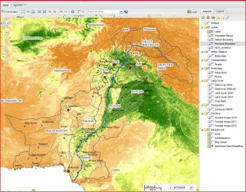
5 Portal Main User Interface


 as data or charts Crop Health Status: agromet variables compared to")

6 Portal modules Crop Data Explorer: set filters, area of interest and time period and produce outputs such as tables, charts and choropleth maps Agro-Meteorological Data Explorer: set filters to extract statistics on variables such as temperature, precipitation, decadal NDVI, etc..) as data or charts Crop Health Status: agromet variables compared to the requirements of a selected crop in a selected growing season Map Composer: WEB mapping application based on International standards allowing local or remote datasets to be displayed and analyzed in a GIS like environment
 Filter available crops by season (Rabi) Select area of interest Type: Group of District (from list or by clicking on")
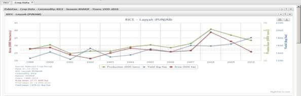
7 RESULTS Example of use Task: chart annual trend of wheat data in 3 districts of Punjab Crop data can be retrieved and analyzed using the graphic interface on the left. The system allows users to: Select output type Generate time-series charts (Chart) Filter available crops by season (Rabi) Select area of interest Type: Group of District (from list or by clicking on map) Identify crop of interest (wheat) Select time interval for the averaging ( ) Select Units of Measure (default)
8 Example of use Task: chart annual trend of wheat data in 3 districts of Punjab

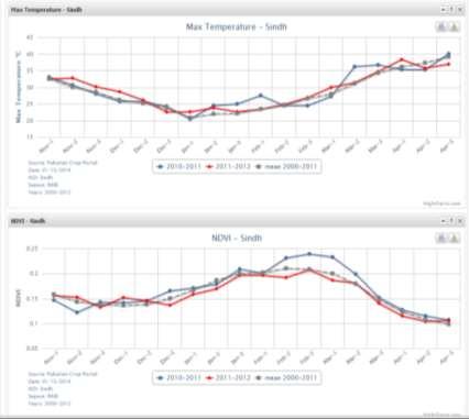
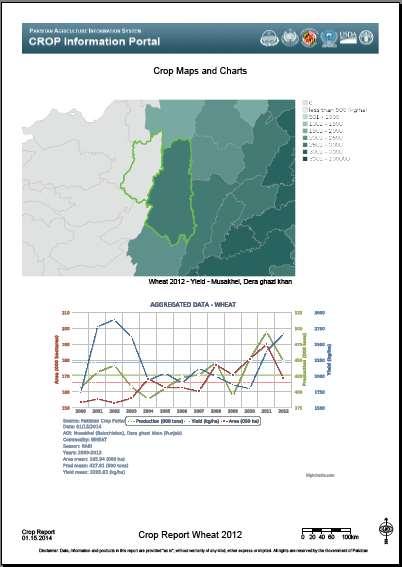
9 Examples of Outputs


10 Main Benefits One shop access to historical data on annual crop production, harvested area and yield and seasonal trend of agro-met variables Harmonization of data currently scattered at national and local institutions, in various formats and units Improvement in data management Standardization, minor effort in data merging and reduction of errors Improvement in data access Ability to easily generate customized charts, maps and reports based on subsets of data stored in primary DB Improvement in CRS s regular crop reporting Custom charts and maps can be generated and extracted for a rapid enrichment of monthly bulletins with ancillary data


11 Training Workshop on Crop Information Portal and GeoNetwork software Jan FAO and SUPARCO organized a two week training workshop in Islamabad: Jan 20-23: Administrating the Crop Information Portal Jan 24-27: Using the Crop Information Portal Jan 28-31: GeoNetwork opensource software Nineteen experts from Crop Reporting Services of Punjab, Sindh, Khyber Pakhtunkhwa and Baluchistan; from the Agriculture Universities of Tandojam and Faisalabad and from SUPARCO 11
12 What NEXT User feedback collected during trainings and workshops were used to develop a set of updates to be implemented this last year of project activities (end September 2015). Such development is currently on going. Main groups of updates are: Filtering: Scalable charting and user defined data seasonal limits for Agromet/NDVI data. Data: Include data on fertilizers, irrigation water and market prices; also, include alternative crop data estimates. Charting: Compare alternative areas or crops in one chart; the choice of different chart types (lines, bars, pies etc..); the choice of user defined units of measure (e.g. acres for areas), and more. The next slides summarize some of the most exciting updates The finalization of this second version of the Portal is estimated for the end of May 2015.

13 Alternative Chart Types Combination of types and rendering Comparison of different areas for a selected crop Stacking data
14 Alternative Chart Types Combination of types and rendering Comparison of different areas for a selected crop Stacking data

15 Alternative Chart Types Combination of types and rendering Comparison of different areas for a selected crop Stacking data

16 Combined agro-met variables Combined chart on 12 months time range


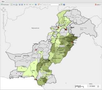
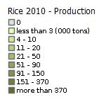
17 Improved Mapping Map selected year Map Average selected period Map Anomalies map of 2010 harvested area with rice

18 Improved Mapping Map selected year Map Average selected period Map Anomalies map of average production for wheat

19 Improved Mapping Map selected year Map Average selected period Map Anomalies map of 2012 minus average area for sugarcane
 (*) Currently, the database is empty except for few records used to")
20 Improved data content Fertilizers consumption Water discharge Market prices Additional sources of crop data Annual summaries per province (*) (*) Currently, the database is empty except for few records used to test
 (*) Currently, the database is empty except for few records used to test (only Nitrogen, 5 months in")
21 Improved data content Fertilizers consumption Water discharge Market prices Additional sources of crop data Monthly data per District (*) (*) Currently, the database is empty except for few records used to test (only Nitrogen, 5 months in 2011)


22 Improved data content Fertilizers consumption Water discharge Market prices Additional sources of crop data Modules under construction as we speak
23 International Conference on Innovative Agricultural Financing April 28-29, 2015 at Hotel Serena Islamabad Day 1 Tuesday 28 April 2015 Session B: Digital platforms in building data-ecosystem for agri-finance Thank you Crop Information Portal Agriculture Information System Building Provincial Capacity for Crop Forecasting and Estimation Mr. Muhammad Iftekhar Bhatti General Manager (RS & GIS), SUPARCO
Agriculture Information System. Crop Information Portal of Pakistan: version 2 Database Administration
 Agriculture Information System Building Provincial Capacity for Crop Forecasting and Estimation Crop Information Portal of Pakistan: version 2 Database Administration Antonio Martucci (FAO-DDNS) Task 1:
Agriculture Information System Building Provincial Capacity for Crop Forecasting and Estimation
 Agriculture Information System Building Provincial Capacity for Crop Forecasting and Estimation Introduction to the Project and SUPARCO s support Imran Iqbal (SUPARCO) Islamabad, 29 th Oct 2014 The Project
Pakistan: How SUPARCO Makes Crop Forecasts and Estimates based on integral use of RS data. A joint FAO, UN & SUPARCO publication
 P a k i s t a n S p a c e a n d U p p e r A t m o s p h e r e R e s e a r c h C o m m i s s i o n Pakistan: How SUPARCO Makes Crop Forecasts and Estimates based on integral use of RS data A joint FAO,
AREA AND PRODUCTION ESTIMATE
 1 AREA AND PRODUCTION ESTIMATE AREA ESTIMATE The Crop Reporting Service release three estimates of area, production and average yield. Area estimate provides area under the crop. It is prepared on the
CROP BULLETIN CONTENT
 Crop Reporting Service, Punjab VOLUME-II, ISSUE-5, SERIAL #17 CONTENT Crop Situation Summary April, 2015 1 Normalized Difference Vegetation index (NDVI) of Punjab Province (GLAM) 1 Wheat Analysis 2013-14
Pakistan Agricultural Information Systems Project
 Pakistan Agricultural Information Systems Project Designing Provincial Crop Outlook Reports: A Discussion-Meeting with Stakeholders Islamabad, Pakistan February 25, 2014 Dath K. Mita, PhD Senior Global
CROP BULLETIN CONTENT
 Crop Reporting Service, Punjab VOLUME-II, ISSUE-7, SERIAL #19 CONTENT Crop Situation Summary June, 2015 1 Normalized difference vegetation index (NDVI Graph) at Divisional Level, June, 2015 2 July, 2015
CRS CROP BULLETIN CROPS SITUATION SEPTEMBER,2014 SUMMARY
 CRS CROP BULLETIN CROPS SITUATION SEPTEMBER,2014 SUMMARY In the month of September, 2014 hundreds of villages have been badly affected, several marooned, by exceptionally heavy rains and high flash floods
UN FAO Tools. Douglas Muchoney, FAO Forum of Experts in SEEA Experimental Accounting 2018 Glen Cove, New York June 2018
 UN FAO Tools Douglas Muchoney, FAO Forum of Experts in SEEA Experimental Accounting 2018 Glen Cove, New York 18-20 June 2018 Land evaluation and planning The Agro Ecological Zones (AEZ) process is the
CROP BULLETIN CONTENT
 Crop Reporting Service, Punjab VOLUME-II, ISSUE-8, SERIAL #20 CONTENT Crop Situation Summary July, 2015 1 Normalized difference vegetation index (NDVI Graph) at Divisional Level, July, 2015 2 Normalized
CROP BULLETIN CONTENT
 Crop Reporting Service, Punjab VOLUME-II, ISSUE-1, SERIAL #13 CONTENT Crop Situation Summary March, 2015 1 Normalized Difference Vegetation index (NDVI)of Punjab Province (GLAM) 1 Rabi crop situation 2
CRS CROP BULLETIN CROPS SITUATION MAY,2015 SUMMARY. 1 CRS, Pb. Crop Bulletin June 2015-Vol-II, Issue 6, Serial # 18
 CRS CROP BULLETIN CROPS SITUATION MAY,2015 SUMMARY The farmers main activity in the month of May is the harvesting of wheat crop and sowing of Kharif crops. The wheat crop growth period was observed as
Crop water requirement and availability in the Lower Chenab Canal System in Pakistan
 Water Resources Management III 535 Crop water requirement and availability in the Lower Chenab Canal System in Pakistan A. S. Shakir & M. M. Qureshi Department of Civil Engineering, University of Engineering
Climate Smart Agriculture in Pakistan
 Climate Smart Agriculture in Pakistan Current status and Future challenges Dr. Tasneem Khaliq Assistant Professor Agro-Climatology Lab., Department of Agronomy University of Agriculture Faisalabad Overview
Crop Mask for Sugarcane, Rice and Cotton Crops in Punjab & Sindh, Pakistan
 Crop Mask for Sugarcane, Rice and Cotton Crops 2014-15 in Punjab & Sindh, Pakistan ii ii i i ii Table of Contents 1. Introduction... 1 2. Objectives... 1 3. Basic Guidelines... 1 4. Quality Control...
DSS for monitoring agro-meteorological and crop conditions in India using remote sensing for agro-advisory services. Montpellier March 16-18, 2015
 DSS for monitoring agro-meteorological and crop conditions in India using remote sensing for agro-advisory services Vinay Sehgal, Malti Singh, Rakeshwar Verma, Ananta Vashisth, Himanshu Pathak ICAR - Indian
To provide timely, accurate, and useful statistics in service to U.S. agriculture
 NASS MISSION: To provide timely, accurate, and useful statistics in service to U.S. agriculture What does NASS do? Administer USDA s Statistical Estimating Program Conduct the 5-year Census of Agriculture
Crop Assessment using Space, Agro-Meteorology & Land based observations : Indian Experience
 Crop Assessment using Space, Agro-Meteorology & Land based observations : Indian Experience Shibendu S. Ray Mahalanobis National Crop Forecast Centre Department of Agriculture, Cooperation & Farmers Welfare,
PAKISTAN MARKET MONITORING BULLETIN
 T H E U N I T E D N A T I O N S W O R L D F O O D P R O G R A M M E PAKISTAN MARKET MONITORING BULLETIN J A N U A R Y - A P R I L 2 0 1 1 Highlights Approximately 5.6 million people in the flood affected
Remote Sensing for Agricultural Applications
 Remote Sensing for Agricultural Applications Shibendu S. Ray Mahalanobis National Crop Forecast Centre Department of Agriculture, Cooperation & Farmers Welfare, New Delhi shibendu.ncfc@gov.in GeoSmart
Climate Data and Drought Research
 Climate Data and Drought Research Can NLWIS Help the Drought Research Initiative? A. Howard: Agriculture and Agri-Food Canada What is the National Land and Water Information Service? An across-canada,
Use of Remote Sensing Technology in Crop Monitoring and Assessment of Impact of Natural Disaster
 Use of Remote Sensing Technology in Crop Monitoring and Assessment of Impact of Natural Disaster Shibendu S. Ray Mahalanobis National Crop Forecast Centre Department of Agriculture & Cooperation Government
Monitoring of Crops through Satellite Technology
 P a k i s t a n S p a c e a n d U p p e r A t m o s p h e r e R e s e a r c h C o m m i s s i o n Advanced Training on Monitoring of Crops through Satellite Technology A joint FAO, UN & SUPARCO publication
Agroclimatic Modelling for Estimation of Wheat Production in the Punjab Province, Pakistan
 Proceedings of the Pakistan Academy of Sciences 49 (4): 241 249 (2012) Pakistan Academy of Sciences Copyright Pakistan Academy of Sciences ISSN: 0377-2969 print / 2306-1448 online Research Article Agroclimatic
GEOGLAM international cooperation activities
 GEOGLAM international cooperation activities Chris Justice Center for Global Agricultural Monitoring and Research Dept. of Geographical Sciences University of Maryland GEO: an International Coordinating
Evaluation of Indices for an Agricultural Drought Monitoring System in Arid and Semi-Arid Regions
 Evaluation of Indices for an Agricultural Drought Monitoring System in Arid and Semi-Arid Regions Alireza Shahabfar, Josef Eitzinger Institute of Meteorology, University of Natural Resources and Life Sciences
Crop monitoring and yield forecasting MARS activities in South America
 Crop monitoring and yield forecasting MARS activities in South America Raúl LÓPEZ LOZANO European Commission, Joint Research Centre GLOBCAST dissemination event Conference Centre Albert Borschette Brussels,
The GEO Global Agricultural Monitoring Initiative (GEOGLAM): Overview
: Overview") The GEO Global Agricultural Monitoring Initiative (GEOGLAM): Overview Chris Justice (UMD) 1 / 27 GEO the Group on Earth Observations an Intergovernmental Organization with 90 Members and 67 Participating
The GEO Global Agricultural Monitoring Initiative (GEOGLAM): Overview Chris Justice (UMD) 1 / 27 GEO the Group on Earth Observations an Intergovernmental Organization with 90 Members and 67 Participating
Agricultural Crop Monitoring Programme in India
 Agricultural Crop Monitoring Programme in India Dr. Jai Singh Parihar Dy. Director Remote Sensing Applications Area (RESA) Space Applications Centre (ISRO) Ahmedabad 380 015 India jsparihar@sac.isro.gov.in
GEOGLAM, Michel Deshayes, GEO, GEOGLAM Coordinator for the Agricultural Community of Practice
 GEOGLAM, Global Agricultural Monitoring Michel Deshayes, GEO, GEOGLAM Coordinator for the Agricultural Community of Practice GEO, Group on Earth Observations Created in 2005, to develop a coordinated and
Crop mapping with satellite data
 Crop mapping with satellite data Dr. C.S. Murthy Head, Agricultural Sciences and Applications National Remote Sensing Centre, Hyderabad murthy_cs@nrsc.gov.in, csmurthy09@gmail.com Geospatial Technology
DEVELOPMENT OF A DECISION SUPPORT SYSTEM FOR NATURAL DAMAGE ASSESSMENT BASED ON REMOTE SENSING AND BIO-PHYSICAL MODELS
 DEVELOPMENT OF A DECISION SUPPORT SYSTEM FOR NATURAL DAMAGE ASSESSMENT BASED ON REMOTE SENSING AND BIO-PHYSICAL MODELS M.A. Sharifi a*, W.G.M. Bastiaanssen b, S.J. Zwart b a ITC, P.O. Box 6, 7500 AA, Enschede,
Trend Analysis and Forecasting of Maize Area and Production in Khyber Pakhtunkhwa, Pakistan
 EUROPEAN ACADEMIC RESEARCH Vol. II, Issue 4/ July 2014 ISSN 2286-4822 www.euacademic.org Impact Factor: 3.1 (UIF) DRJI Value: 5.9 (B+) Trend Analysis and Forecasting of Maize Area and Production in SALEEM
LAND SUITABILITY ASSESSMENT FOR MAIZE CROP IN OKARA DISTRICT USING GIS TECHNIQUES
 LAND SUITABILITY ASSESSMENT FOR MAIZE CROP IN OKARA DISTRICT USING GIS TECHNIQUES 1* Amira Baber Sheikh, 2 Shahid Parvez, 3 Muhammad Ikram, 4 Humaira Baber 1 M.Phil Student, Dept of Space Science, University
Global Strategy IMPROVING AGRICULTURAL AND RURAL STATISTICS IN ASIA PACIFIC
 Global Strategy IMPROVING AGRICULTURAL AND RURAL STATISTICS IN ASIA PACIFIC Improving Administrative Reporting Systems in Asia Pacific Region Global Strategy Training and Outreach Workshop on Agricultural
IMPLEMENTATION REPORT
 Biomass Resource Mapping in Pakistan IMPLEMENTATION REPORT December 20 This report was prepared by Full Advantage Co. Ltd [Lead Consultant], Simosol Oy, VTT Technical Research Center of Finland and PITCO
Climate Change Challenges faced by Agriculture in Punjab
 Climate Change Challenges faced by Agriculture in Punjab Dr. M. Mohsin Iqbal and Dr. Arshad M. Khan Global Change Impact Studies Centre (GCISC), Islamabad Seminar on Impacts of Climate Change on Agriculture
Ms. Le Thi Quy Nien Agriculture Solutions Sales and Distribution IBM Vietnam Smarter Agriculture
 Ms. Le Thi Quy Nien Agriculture Solutions Sales and Distribution IBM Vietnam nienlq@vn.ibm.com Smarter Agriculture Cognitive IOT Solutions: Digital Precision Forestry Agricultural, Industrial & Infrastructure
Vol.3, No.1, May, 2010 Agriculture Marketing, Government of the Punjab, Lahore
 Agri-Marketing e-news Vol.3, No.1, May, 2010 Agriculture Marketing, Government of the Punjab, Lahore Chief Minister Punjab inaugurates the Punjab Investment Conference 2010 on 03 May, 2010 in Karachi for
Need Additional Information? LEGAL DISCLAIMER ACKNOWLEDGEMENT:
 LEGAL DISCLAIMER This work was implemented as part of the CGIAR Research Program on Climate Change, Agriculture and Food Security (CCAFS) hosted by BISA-CIMMYT in South Asia. The views expressed in this
Crop monitoring and yield forecasting MARS activities in Asia
 Crop monitoring and yield forecasting MARS activities in Asia Rémi Lecerf European Commission, Joint Research Centre GLOBCAST dissemination event Conference Centre Albert Borschette Brussels, 30 September
FORECAST MODELS FOR SUGARCANE
 Pak. J Agri. Sci., Vol. 41(1-2), 2004 FORECAST MODELS FOR SUGARCANE IN PAKISTAN M. Asif Masoood* and Malik Anver Javed Biometrics Programme, Social Sciences Institute, National Agricultural Research Centre,
Modeling Economywide Impacts of Water Policies in Pakistan
 Modeling Economywide Impacts of Water Policies in Pakistan Sherman Robinson and Arthur Gueneau International Food Policy Research Institute (IFPRI) December 14, 2012 - Islamabad Plan of the Presentation
Global Strategy. Session 1.2: Minimum Set of Core Data Items. Module 1: Sampling in the Context of the Global Minimum Set of Core Data Items
 Global Strategy IMPROVING AGRICULTURAL AND RURAL STATISTICS IN ASIA PACIFIC Module 1: Sampling in the Context of the Global Minimum Set of Core Data Items Session 1.2: Minimum Set of Core Data Items 13
Global crop yield prediction using seasonal climate forecast data
 GEOSS Asia Pacific Symposium 2018 Global crop yield prediction using seasonal climate forecast data Toshichika Iizumi National Agriculture and Food Research Organization (NARO) Japan October 24, 2018 Kyoto
Factors Affecting Cotton Production in Pakistan: Empirical Evidence from Multan District
 Volume V, Issue I1, Dec, 2009, pg. 91-100 Factors Affecting Cotton Production in Pakistan: Empirical Evidence from Multan District Imran Sharif Chaudhry, Muhammad Bashir Khan Department of Economics, Bahauddin
Satellite image classification of vegetation and surface water for assessment of flood damage to agricultural crops
 Satellite image classification of vegetation and surface water for assessment of flood damage to agricultural crops Lisa Colson 2, Mark Lindeman 1, Dath Mita 1, Tatiana Nawrocki 2, Paulette Sandene 1,
Agricultural drought index and monitoring on national scale. LU Houquan National Meteorological Center, CMA
 Agricultural drought index and monitoring on national scale LU Houquan National Meteorological Center, CMA Contents Agricultural drought disasters in China Agricultural drought indices --Precipitation
FINAL REPORT ON BIOMASS ATLAS
 Public Disclosure Authorized Public Disclosure Authorized Biomass Resource Mapping in Pakistan FINAL REPORT ON BIOMASS ATLAS June 2016 Public Disclosure Authorized Public Disclosure Authorized This report
Dynamic Image Processing for Landuse Analysis & Precision Agriculture. Hari Yeruva, GISP
 Dynamic Image Processing for Landuse Analysis & Precision Agriculture Hari Yeruva, GISP CONCEPT OF PRECISION AGRICULTURE Farming by the Square Foot Traditional Mgt. Precision Mgt. 1-10+ Acres 0.1-0.001
Monitoring croplands using Remote sensing
 Monitoring croplands using Remote sensing Murali Krishna Gumma and team ICRISAT Dryland agriculture, where ICRISAT operating Geospatial World Forum: Knowledge based agriculture: the linkages with sustainability,
Application of Mathematical Modelling to Development Issues: An Illustrative Model on Agricultural Systems 1
 Application of Mathematical Modelling to Development Issues: An Illustrative Model on Agricultural Systems 1 Shahid Ahmad 2 Abstract Agricultural systems are diverse in nature depending upon the agro-ecology,
APPLICATION OF GEO SPATIAL TECHNOLOGY IN AGRICULTURE
 APPLICATION OF GEO SPATIAL TECHNOLOGY IN AGRICULTURE Dr. S.C. Moharana Senior Scientist ORSAC, Bhubaneswar Training Programme on Applications of Geo-Spatial Technology Oct 14, 2017 FASAL Programme Implemented
AGRICULTURAL GROWTH AND PRODUCTIVITY ENHANCEMENT
 AGRICULTURAL GROWTH AND PRODUCTIVITY ENHANCEMENT Presentation at Roundtable Discussion on Agriculture and Water By Dr. Muhammad Jameel Khan Advisor (Agri. Planning) Planning Commission (08-03-2011) NEW
Status and challenges of soil management in the Middle East
 Status and challenges of soil management in the Middle East Managing Living Soils - Technical Workshop 5-7 December 2012 FAO Headquarters Rome, Italy Feras M. Ziadat 1 About ICARDA One of 15 CGIAR centres
presented by Dr. Muhammad Zia ur Rahman Hashmi, Senior Scientific Officer Global Change Impact Studies Centre (GCISC)
") presented by Dr. Muhammad Zia ur Rahman Hashmi, Senior Scientific Officer Global Change Impact Studies Centre (GCISC) SDPI s Sustainable Development Conference (SDC), 9-11 Dec, 2014 Presentation layout
presented by Dr. Muhammad Zia ur Rahman Hashmi, Senior Scientific Officer Global Change Impact Studies Centre (GCISC) SDPI s Sustainable Development Conference (SDC), 9-11 Dec, 2014 Presentation layout
Symposium on the Public-Private Partnership to Manage Soil Fertility: Promotion of 4Rs Nutrient Stewardship, 3 February 2015, Islamabad
 Media Update 2 February 2015 FAO MEDIA ADVISORY Symposium on the Public-Private Partnership to Manage Soil Fertility: Promotion of 4Rs Nutrient Stewardship, 3 February 2015, Islamabad WHAT: The Food and
PHASE 2 IMPLEMENTATION PLAN
 Public Disclosure Authorized Public Disclosure Authorized Biomass Resource Mapping in Pakistan PHASE 2 IMPLEMENTATION PLAN March 20 Public Disclosure Authorized Public Disclosure Authorized This report
CLIMATE CHANGE ADAPTIVE CROP PRODUCTION STRATEGIES IN HIGH ALTITUDE AND TRIBAL AREAS OF VISAKHAPATNAM DISTRICT, A.P
 CLIMATE CHANGE ADAPTIVE CROP PRODUCTION STRATEGIES IN HIGH ALTITUDE AND TRIBAL AREAS OF VISAKHAPATNAM DISTRICT, A.P K. SASIKALA * and P. ASHOK Regional Agricultural Research Station, Chintapalli, Visakhapatnam
CropWatch and ETWatch for Food Security. Bingfang Wu Institute of Remote Sensing and Digital Earth (RADI) Chinese Academy of Sciences
 Chinese Academy of Sciences") CropWatch and ETWatch for Food Security Bingfang Wu Institute of Remote Sensing and Digital Earth (RADI) Chinese Academy of Sciences January 24th, 2017 INTRODUCTION Remote Sensing can be used to improve
CropWatch and ETWatch for Food Security Bingfang Wu Institute of Remote Sensing and Digital Earth (RADI) Chinese Academy of Sciences January 24th, 2017 INTRODUCTION Remote Sensing can be used to improve
GEOGLAM Crop Assessment Tool
 GEOGLAM Crop Assessment Tool Supporting Evidence for the Crop Monitor Michael Humber, Jon Nordling Inbal Becker-Reshef, Brian Barker, Katie McGaughey, Chris Justice, Michel Deshayes Center for Global Agricultural
South Asia Drought Monitoring System (SADMS) A Collaborative project by IWMI, GWP and WMO under Integrated Drought Management Programme
 A Collaborative project by IWMI, GWP and WMO under Integrated Drought Management Programme") South Asia Drought Monitoring System (SADMS) A Collaborative project by IWMI, GWP and WMO under Integrated Drought Management Programme NDVI 2002 NDVI 2003 Giriraj Amarnath, Niranga Alahacoon, Peejush
South Asia Drought Monitoring System (SADMS) A Collaborative project by IWMI, GWP and WMO under Integrated Drought Management Programme NDVI 2002 NDVI 2003 Giriraj Amarnath, Niranga Alahacoon, Peejush
The MARS, GLOBCAST & GEOGLAM Crop Yield monitoring and Forecasting Systems and their potential Application in Bangladesh
 The MARS, GLOBCAST & GEOGLAM Crop Yield monitoring and Forecasting Systems and their potential Application in Bangladesh Jacques Delincé, Global Strategy ESS-FAO Rome Slides from: O. Léo (MARS-JRC) I.
Application of Remote Sensing derived land surface information to enhance implementation of management practices in SWAT Presented by Jeba Princy R
 Application of Remote Sensing derived land surface information to enhance implementation of management practices in SWAT Presented by Jeba Princy R Balaji Narashimhan V.M.Bindhu, S.M. Kirthiga Annie Issac
FASAL: The Operational Programme for Crop Assessment in India
 FASAL: The Operational Programme for Crop Assessment in India 23 Jul, 17 Aug, 11 Sep 2015 13 Jul, 7 Aug, 1 Sep 2014 Neetu Mahalanobis National Crop Forecast Centre Ministry of Agriculture & Farmers Welfare,
Table 4.1. CropWatch agroclimatic and agronomic indicators for China, October 2016-January 2017, departure from 5YA and 15YA
 65 Chapter 4. China Chapter 4 presents a detailed analysis for China, focusing on the seven most productive agro-ecological regions of the east and south. After a brief overview of the agroclimatic and
Session 4: Agri-Environmental statistics and indicators within FAOSTAT
 Session 4: Agri-Environmental statistics and indicators within FAOSTAT Workshop on Environment Statistics (Yaounde, Cameroon, 5-9 December 2011) Characteristics of Agri-Environmental data Problems of scale:
Climate services competencies
 Climate services competencies The provision of climate services within a National Meteorological and Hydrological Service (NMHS) or related services might be accomplished by a variety of skilled personnel,
Indus River System Model: A planning tool to explore Water-Energy-Food nexus for Pakistan
 Indus River System Model: A planning tool to explore Water-Energy-Food nexus for Pakistan Mobin-ud-Din Ahmad, Joel Stewart, Geoff Podger Managing Systems Under Stress: Science for Solutions in the Indus
Global Assessment of impacts of climate change on agricultural productivity the FAO GAEZ portal
 Global Assessment of impacts of climate change on agricultural productivity the FAO GAEZ portal John Latham, Gianluca Franceschini Geospatial Coordination Unit (GCU) Climate and Biodiversity Department;
SECTOR ASSESSMENT (SUMMARY): AGRICULTURE, NATURAL RESOURCES, and RUDAL DEVELOPMENT. 1. Sector Performance, Problems, and Opportunities
: AGRICULTURE, NATURAL RESOURCES, and RUDAL DEVELOPMENT. 1. Sector Performance, Problems, and Opportunities") Pehur High Level Canal Extension Project (RRP PAK 47024) SECTOR ASSESSMENT (SUMMARY): AGRICULTURE, NATURAL RESOURCES, and RUDAL DEVELOPMENT Sector Road Map 1. Sector Performance, Problems, and Opportunities
Pehur High Level Canal Extension Project (RRP PAK 47024) SECTOR ASSESSMENT (SUMMARY): AGRICULTURE, NATURAL RESOURCES, and RUDAL DEVELOPMENT Sector Road Map 1. Sector Performance, Problems, and Opportunities
Early Warning Systems on Food and Agriculture
 Early Warning Systems on Food and Agriculture Presentation by Stéphane Jost, Master in Human Development & Food Security Università Roma 3-18 May 2017 Early Warning Systems on Food and Agriculture Early
Global Agricultural Monitoring International Coordination: GEOGLAM
 Global Agricultural Monitoring International Coordination: GEOGLAM Chris Justice NASA - Earth Observation for Food Security and Agriculture Consortium Department of Geographical Sciences, University of
BUILDING ADAPTATIVE CAPACITY TO CLIMATE CHANGE IN A LEAST DEVELOPED COUNTRY (LDC) THE RURAL SECTOR IN MALI
 THE RURAL SECTOR IN MALI") BUILDING ADAPTATIVE CAPACITY TO CLIMATE CHANGE IN A LEAST DEVELOPED COUNTRY (LDC) THE RURAL SECTOR IN MALI Mama KONATE Director General, National Met Service UNFCCC Focal Point Bamako - MALI 1 BRIEF OVERVIEW
BUILDING ADAPTATIVE CAPACITY TO CLIMATE CHANGE IN A LEAST DEVELOPED COUNTRY (LDC) THE RURAL SECTOR IN MALI Mama KONATE Director General, National Met Service UNFCCC Focal Point Bamako - MALI 1 BRIEF OVERVIEW
Research Article IJAER (2017); 3(2):
; 3(2):") Research Article IJAER (2017); 3(2): 250 259 International Journal of Agricultural and Environmental Research FREE AND OPEN ACCESS Available online at www.ijaaer.com ISSN 2414-8245 (Online) ISSN 2518-6116
Research Article IJAER (2017); 3(2): 250 259 International Journal of Agricultural and Environmental Research FREE AND OPEN ACCESS Available online at www.ijaaer.com ISSN 2414-8245 (Online) ISSN 2518-6116
DMH Strategies for Agro-Met Development in Myanmar
 Climate Services Users Forum for Agriculture (CSUF-Ag2) DMH Strategies for Agro-Met Development in Myanmar Ms. May Khin Chaw Deputy Director, Agro-met Division, Myanmar Hotel Royal ACE, Nay Pyi Taw, Myanmar
Application of Satellite Rainfall Monitoring in Flood Management of Indus River
 Application of Satellite Rainfall Monitoring in Flood Management of Indus River Takahiro Konami Hydrological Systems and Water Scarcity Section International Hydrological Programme (IHP) UNESCO Monitoring
Guided by WMO-134 ( Guide to Agricultural Meteorological Practices (GAMP) 2007 completely revised version) Sistana SCADA Systems Ltd.
 2007 completely revised version) Sistana SCADA Systems Ltd.") Agricultural Decision Support System Guided by WMO-134 ( Guide to Agricultural Meteorological Practices (GAMP) 2007 completely revised version) Sistana SCADA Systems Ltd. Agricultural Decision Support
Agricultural Decision Support System Guided by WMO-134 ( Guide to Agricultural Meteorological Practices (GAMP) 2007 completely revised version) Sistana SCADA Systems Ltd. Agricultural Decision Support
Climate Services Toolkit
 Climate Services Toolkit Summary of discussions Anahit Hovsepyan World Meteorological Organization ahovsepyan@wmo.int Climate Services Toolkit Features and Functions 2 CST Objectives To ensure that climate-sensitive
Climate Services in the Caribbean Related Activity to Date
 Climate Services in the Caribbean Related Activity to Date A D R I A N T R O T M A N C H I E F, A P P L I E D M E T E O R O L O G Y A N D C L I M A T O L O G Y C A R I B B E A N I N S T I T U T E F O R
Economic Analysis of Hybrid Maize Cultivation in Distt; Naushahro Feroze, Sindh, Pakistan
 Economic Analysis of Hybrid Maize Cultivation in Distt; Naushahro Feroze, Sindh, Pakistan Mansoor Ahmed Koondhar 1, Abbas Ali Chandio 2, He Ge *1, Xiao Xu 3, Masroor Ali Koondhar 4 1,2,3 Faculty of Agricultural
The CropWatch Bulletin may cover different major production zones in subsequent issues.
 76 Chapter 6 Background 6.1 Geographic units of analysis This bulletin adopts the Global Administrative Units Layer (GAUL) boundaries for all national and subnational units, except for China, where official
Seasonal Monitoring in DPRK 2014
 Seasonal Monitoring in DPRK 2014 Lower crop production expected compared to 2013 Anne Schucknecht, Francois Kayitakire, Hervé Kerdiles September 2014 Absolute NDVI anomalies between the current year (2014)
 A downstream service to support agro-production, planning and policy FP7-SPACE-2013-1- CALL Contract N : 606983 http://www.ermes-fp7space.eu/ ERMES 1st Annual Meeting 26-27/03/2015 - Valencia End-Users
EARLY SEASON FORECASTING OF CROPS BY FASAL ECONOMETRIC MODEL
 EARLY SEASON FORECASTING OF CROPS BY FASAL ECONOMETRIC MODEL Presented at International Workshop on Operational Mapping/Monitoring of Agricultural Crops in South/Southeast Asian Countries Research Needs
Engr. Md. Waji Ullah Executive Director, CEGIS and Member, JRC
 Operationalization of South Asia Drought Management and Monitoring System (SADMS) Engr. Md. Waji Ullah Executive Director, CEGIS and Member, JRC Outline Drought Background and Events in Bangladesh Driving
Pakistan Food Security Bulletin Issue 5 (Period: July December 2016) January, 2017
 January, 2017") Issue 5 (Period: July December 2016) January, 2017 The Pakistan Food Security Bulletin is produced by the Vulnerability Analysis and Mapping (VAM) Unit of the World Food Programme as a contribution to
Issue 5 (Period: July December 2016) January, 2017 The Pakistan Food Security Bulletin is produced by the Vulnerability Analysis and Mapping (VAM) Unit of the World Food Programme as a contribution to
Crop Monitoring System in Bangladesh, Main Challenges, Recent Initiatives and Prospects
 Crop Monitoring System in Bangladesh, Main Challenges, Recent Initiatives and Prospects Dr. Farida Perveen Additional Deputy Director Department of Agricultural Extension (DAE) Date:26 May, 2016 Overview
Dr Muhammad Anjum Ali DGA(Ext &AR) Punjab
 Punjab") Dr Muhammad Anjum Ali DGA(Ext &AR) Punjab Village Cooperative Movement Village Agricultural and Industrial Development Programme ( V Aid) Agriculture Development Corporation (ADC) Integrated Rural Development
Dr Muhammad Anjum Ali DGA(Ext &AR) Punjab Village Cooperative Movement Village Agricultural and Industrial Development Programme ( V Aid) Agriculture Development Corporation (ADC) Integrated Rural Development
Managing Extreme Floods in Pakistan
 Managing Extreme Floods in Pakistan Shahbaz Khan Chief, Water and Sustainable Development UNESCO Division of Water Sciences 2 Monsoon 2010 : Extreme Rainfall - Flood INTERACTION L Monsoon 2010 (July) Interaction
Impact evaluation for: Special Program for Food Security and Productivity Enhancement of Small Farmers in Pakistan (Crop Maximization Project-II)
") Impact evaluation for: Special Program for Food Security and Productivity Enhancement of Small Farmers in Pakistan (Crop Maximization Project-II) Section A: Presentation of project Area and Target Group
Impact evaluation for: Special Program for Food Security and Productivity Enhancement of Small Farmers in Pakistan (Crop Maximization Project-II) Section A: Presentation of project Area and Target Group
Analyzing water resources in a monsoon-driven environment an example from the Indian Western Ghats
 Analyzing water resources in a monsoon-driven environment an example from the Indian Western Ghats 1, Shamita Kumar 2, Peter Fiener 1 and Karl Schneider 1 1,,, Germany 2 Institute of Environment Education
BUILDING EXPOSURE MAPS OF URBAN INFRASTRUCTURE AND CROP FIELDS IN THE MEKONG RIVER BASIN
 BUILDING EXPOSURE MAPS OF URBAN INFRASTRUCTURE AND CROP FIELDS IN THE MEKONG RIVER BASIN E. Haas (1), J. Weichselbaum (1), U. Gangkofner (1), J. Militzer (1), A. Walli (1) (1) GeoVille, Sparkassenplatz
Mainstreaming Satellite Earth Observations and Smart Technology for Addressing Water-Food Security Challenges of Asia
 Mainstreaming Satellite Earth Observations and Smart Technology for Addressing Water-Food Security Challenges of Asia Faisal Hossain University of Washington October 2-4, 2018 CURRENT STATE OF AFFAIRS
Modelling System for Agricultural Impacts of Climate Change
 Modelling System for Agricultural Impacts of Climate Change FAO-MOSAICC is developed in the framework of the EU/FAO Programme on Improved Global Governance for Hunger Reduction. MOSAICC (for MOdelling
PAKISTAN MARKET MONITORING BULLETIN
 PKST MRKET MOTORG BULLET S S U E O 1 6 O C T O B E R 2 0 1 0 This bulletin can b e downloaded from http://vam.wfp.org.pk SDE THS SSUE: TERTOL WHET D RCE MRKET STU- TOS (Page 2) FLOODS MPCT O DO- MESTC
CropWatch. Bingfang Wu Institute of Remote Sensing and Digital Earth (RADI) Chinese Academy of Sciences
 Chinese Academy of Sciences") CropWatch Bingfang Wu Institute of Remote Sensing and Digital Earth (RADI) Chinese Academy of Sciences Goal 2: Zero Hunger Pledges to end hunger, achieve food security, improve nutrition and promote sustainable
CropWatch Bingfang Wu Institute of Remote Sensing and Digital Earth (RADI) Chinese Academy of Sciences Goal 2: Zero Hunger Pledges to end hunger, achieve food security, improve nutrition and promote sustainable
Drought Risk Management Activities in Iranian Space Agency Using Space Technology
 Drought Risk Management Activities in Iranian Space Agency Using Space Technology ABDOLREZA ANSARI AMOLI Remote Sensing & GIS Department Iranian Space Agency (ISA) 21th Intergovernmental Consultative Committee
Climate Change, Agriculture and Food Security in Pakistan: Adaptation Options and Strategies
 October 2013 IDRC CRDI Canada International Development Research Centre Centre de recherches pour le développement international Climate Change Brief Climate Change, Agriculture and Food Security in Pakistan:
Statistical Comparison of floods in Pakistan & Flood prevention through DDM with sensor based Disaster Database Systems.
 Statistical Comparison of floods in Pakistan & Flood prevention through DDM with sensor based Disaster Database Systems. Shakra Mehak Department of Information Technology University of Gujrat Pakistan