MONITORING OF CROP GROWTH AND SOIL MOISTURE RETRIEVAL USING NISAR DATA. HARI SHANKER SRIVASTAVA Indian Institute of Remote Sensing (IIRS),
|
|
|
- Samuel Floyd
- 6 years ago
- Views:
Transcription


, Dehradun 248001")
 https://scholar.google.co.in/citations?")


1 NISAR Science Workshop 2015 Space Applications Centre MONITORING OF CROP GROWTH AND SOIL MOISTURE RETRIEVAL USING NISAR DATA HARI SHANKER SRIVASTAVA Indian Institute of Remote Sensing (IIRS), Indian Space Research Organization (ISRO), Dehradun NASA ISRO Synthetic Aperture Radar (NISAR) CITATION: Srivastava, H. S. (2015), Monitoring of crop growth and soil moisture using NISAR data, NISAR Science Workshop 2015, Nov. 2015, Space Applications Centre (ISRO), Ahmedabad, India
2 NISAR Orbit Repeat Cycle Available Polarimetric Modes S-band L-band 747 km with 98 inclination 12 days Single Pol (SP): HH or VV SP: HH or VV Dual Pol (DP): HH/HV or DP: HH/HV or VV/VH VV/VH CP: RH/RV Compact Pol (CP): Quad Pol (QP): RH/RV HH/HV/VH/VV Quasi-Quad Pol (QQP): HH/HV and VH/VV Swath Width > 240 Km >240 Km Spatial Resolution 6.4m (Az); 2m-6m (Sl- Ra) Incidence Angle Range deg deg 6.9m (Az); 1.9m-30m (Sl-Ra) 2
3 Objectives Retrieval of Soil moisture and mapping and monitoring of agricultural crop parameters using multi frequency, multi incidence angle, polarimetric NISAR and RISAT SAR Surface and deeper layer soil moisture retrieval for bare soil under varying surface roughness conditions Surface and deeper layer soil moisture retrieval underneath crop covered soil Crop parameter retrieval (height, Volume, Plant moisture, fresh biomass, dry biomass) Yield estimation 3


4 RESPONSE OF SHORTER AND LONGER WAVELENGTHS TOWARDS DEEPER LAYER SOIL MOISTURE Srivastava, H.S., Patel, P. and Navalgund, R.R. (2006), How far SAR has fulfilled its expectation for soil moisture retrieval, Proc. of SPIE Vol , pp [available online at: NISAR Science Workshop, SAC Ahmedabad 19th & 20th Nov
 5")
5 MULTI-FREQUENCY SYNTHETIC APERTURE RADAR (SAR) RESPONSE TOWARDS DIFFERENT SURFACE ROUGHNESS CLASSES Srivastava, H.S. (2010), Monitoring of soil moisture using multi-parametric Synthetic Aperture Radar (SAR) data, Ph.D. Thesis, CSJM University, Kanpur (available online at openthesis.com) 5

, How far SAR has fulfilled its expectation for soil moisture retrieval,")
6 MULTI-FREQUENCY & MULTI-POLARIZED DLR E-SAR RESPONSE TOWARDS SURFACE ROUGHNESS & SOIL PROFILE Srivastava, H.S., Patel, P. and Navalgund, R.R. (2006), How far SAR has fulfilled its expectation for soil moisture retrieval, Proc. of SPIE Vol , pp [available online at: 6
 Henderson & Lewis (1998) Interaction of Radar signal with crop covered")
7 (a) (b) (c) (d) (More penetration for longer wavelengths and lower incidence angles) Henderson & Lewis (1998) Interaction of Radar signal with crop covered fields 7
 Henderson &")
8 Ulaby, et. al. (1986) Henderson & Lewis (1998) 8
, An attempt to incorporate the effect of crop cover in soil moisture estimation using multi-incidence angle RADARSAT-1 SAR data, Asian Journal of Geoinformatics (SAR special")
9 EFFECT OF INCIDENCE ANGLE ON SAR SENSITIVITY TOWARDS VEGETATION COVER & SOIL MOISTURE Srivastava, H.S., Patel, P., Manchanda, M.L. and Adiga, S. (2002), An attempt to incorporate the effect of crop cover in soil moisture estimation using multi-incidence angle RADARSAT-1 SAR data, Asian Journal of Geoinformatics (SAR special issue), Vol. 02, No. 03, pp

10 MULTI-FREQUENCY AND MULTI-POLARIZED SYNTHETIC APERTURE RADAR (SAR) RESPONSE TO SCATTERED TREES Srivastava, H. S., Patel, P., Sharma, Y. and Navalgund, R. R., Multi-frequency and multi-polarized SAR response to thin vegetation and scattered trees, Current Science, 2009, vol. 97 (03), pp
, Comparative")

11 MULTI-FREQUENCY MULTI-POLARIZED SAR RESPONSE TOWARDS FOREST PLANTATION Patel, P., Srivastava, H. S., Panigrahy, S. and Parihar, J. S. (2006), Comparative evaluation of the sensitivity of multipolarized multi-frequency SAR backscatter to plant density, International Journal of Remote Sensing, Vol. 27, Issue02, pp

12 MULTI-FREQUENCY & MULTI-POLARIZED DLR E-SAR RESPONSE TOWARDS VEGETATION & SOIL PROFILE Srivastava, H.S., Patel, P. and Navalgund, R.R. (2006), How far SAR has fulfilled its expectation for soil moisture retrieval, Proc. of SPIE Vol , pp [available online at: 12
13 13
14 14
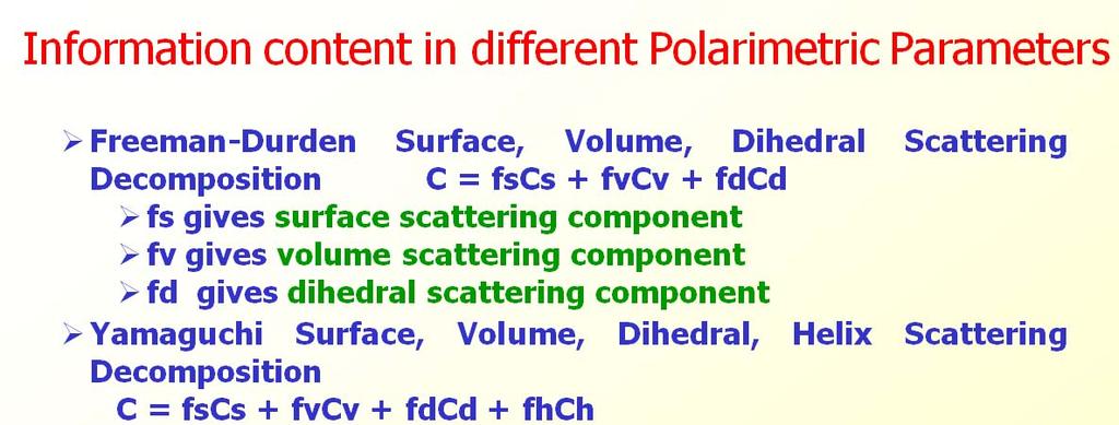
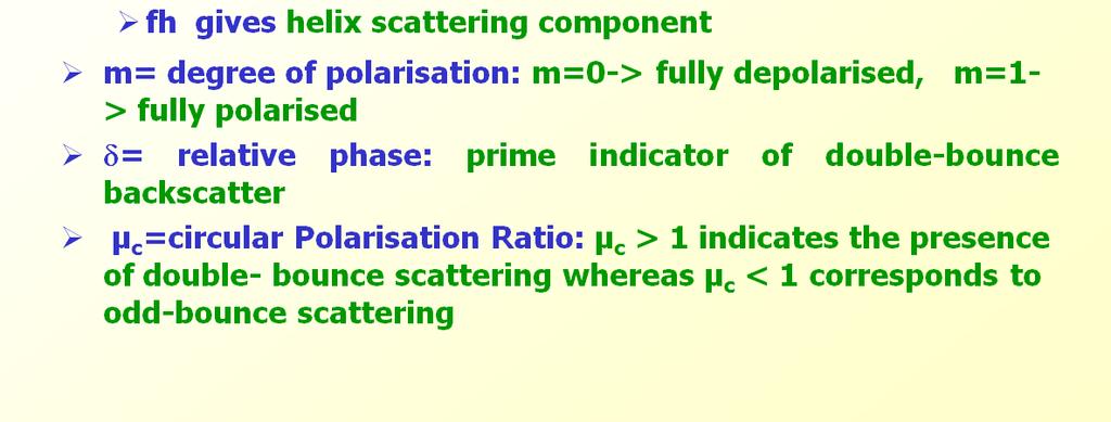
15 15

16 2_ANNOUNCEMENT_OF_OPPORTUNITY_PROJECT_ON_SOIL_MOISTURE_SURFACE_ROUGHNESS_AND_VEGETATION_PAR AMETERS_RETRIEVAL_USING_SAR_POLARIMETRY 16

17 2_ANNOUNCEMENT_OF_OPPORTUNITY_PROJECT_ON_SOIL_MOISTURE_SURFACE_ROUGHNESS_AND_VEGETATION_PAR AMETERS_RETRIEVAL_USING_SAR_POLARIMETRY 17

18 2_ANNOUNCEMENT_OF_OPPORTUNITY_PROJECT_ON_SOIL_MOISTURE_SURFACE_ROUGHNESS_AND_VEGETATION_PAR AMETERS_RETRIEVAL_USING_SAR_POLARIMETRY 18

19 2_ANNOUNCEMENT_OF_OPPORTUNITY_PROJECT_ON_SOIL_MOISTURE_SURFACE_ROUGHNESS_AND_VEGETATION_PAR AMETERS_RETRIEVAL_USING_SAR_POLARIMETRY 19
20 Conclusion It has been observed that multi-frequency, multiincidence angle, multi-polarisation data are sensitive to different target parameters. L, S and C band multi-incidence angle polarimetric SAR data from NISAR and RISAT SAR data would provide information from different component of agricultural terrain. This in turn would be very useful in achieving improved accuracy for retrieval of surface and deeper layer soil moisture for bare as well as crop covered soil and mapping and monitoring of agricultural crop parameters like plant moisture, volume, fresh weight, dry weight and yield estimation. 20
21 Thanks 21
The NISAR Mission. Paul Siqueira Emerging Technologies and Methods in Earth Observation for Agriculture Monitoring College Park, 2018
 The NISAR Mission Paul Siqueira Emerging Technologies and Methods in Earth Observation for Agriculture Monitoring College Park, 2018 Flyer A one-page paper-flyer is available with more information NISAR
Integration of SAR multi-frequency and optical data for the retrieval of soil moisture and vegetation water content
 Integration of SAR multi-frequency and optical data for the retrieval of soil moisture and vegetation water content A. Padovano 1,2, F. Greifeneder 1, R. Colombo 2, G. Cuozzo 1, C. Notarnicola 1 1 - Eurac
I. SOIL MOISTURE, CROP AND VEGETATION STUDY USING AIRSAR DATA
 I. SOIL MOISTURE, CROP AND VEGETATION STUDY USING AIRSAR DATA Dr. Flaviana Hilario (1) and Dr. Juliet Mangera (2) (1) PAGASA (Weather Bureau), ATB 1424 Quezon Ave, Quezon City, Philippines, 1100, Philippines
the wheat fields is small, and as for fields of puddling and leveling in winter and other fields in similar, the difference is small. It is conclude t
 OBSERVATION OF JAPANESE PADDY RICE FIELDS USING MULTI TEMPORAL AND POLARIMETRIC PALSAR DATA PI No.365 Naoki ISHITSUKA 1, Genya SAITO 2, Fan YANG 3, Chinatsu YONEZAWA 4 and Shigeo OGAWA 5 1 National Institute
Applications of SAR Polarimetry on Land: Soil Moisture and Wetlands
 Applications of SAR Polarimetry on Land: Soil Moisture and Wetlands Session Summary and Recommendations R. Touzi and S. Cloude Session Summary T. Jagdhuber et. Al.: Polarimetric Decompositions for Soil
PACRIM-2 Clear-fell Mapping Studies in New Zealand
 PACRIM-2 Clear-fell Mapping Studies in New Zealand D. Pairman, S.J. McNeill, D. McNab* and S.E. Belliss Landcare Research PO Box 69, Lincoln 8152, New Zealand. *Fletcher Challenge Forests. Email: pairmand@landcareresearch.co.nz
Forest Applications. Chris Schmullius, Oliver Cartus, Maurizio Santoro. 5 September 2007, D3PB
 Forest Applications Chris Schmullius, Oliver Cartus, Maurizio Santoro 5 September 2007, D3PB 4 September 2007 D3PB-2 Forest practicals Christiane Schmullius 2 Einführung mit C/X-Äthna-Beispielen MFFU Sommerschule
2528 IEEE TRANSACTIONS ON GEOSCIENCE AND REMOTE SENSING, VOL. 47, NO. 8, AUGUST 2009
 2528 IEEE TRANSACTIONS ON GEOSCIENCE AND REMOTE SENSING, VOL. 47, NO. 8, AUGUST 2009 Large-Area Soil Moisture Estimation Using Multi-Incidence-Angle RADARSAT-1 SAR Data Hari Shanker Srivastava, Parul Patel,
The Biomass mission How it works, what it measures? Thuy Le Toan, CESBIO, Toulouse, France & The Biomass Mission Advisory Group
 The Biomass mission How it works, what it measures? Thuy Le Toan, CESBIO, Toulouse, France & The Biomass Mission Advisory Group Why Synthetic Aperture Radars to observe the world forests? Transmit and
3/1/18 USING RADAR FOR WETLAND MAPPING IMPORTANCE OF SOIL MOISTURE TRADITIONAL METHODS TO MEASURE SOIL MOISTURE. Feel method Electrical resistance
 3/1/18 USING RADAR FOR WETLAND MAPPING SOIL MOISTURE AND WETLAND CLASSIFICATION Slides modified from a presentation by Charlotte Gabrielsen for this class. Southeast Arizona: Winter wet period From C.
RADAR for Biomass Mapping
 RADAR for Biomass Mapping Josef Kellndorfer Wayne Walker, Katie Kirsch, Greg Fiske The Woods Hole Research Center GOFC-GOLD Biomass Workshop Missoula, 15-June-2009 Outline Some Radar principles Measurements
Evaluation of Sentinel-1A Data For Above Ground Biomass Estimation in Different Forests in India. Krishna Prasad Vadrevu NASA MSFC SERVIR
 Evaluation of Sentinel-1A Data For Above Ground Biomass Estimation in Different Forests in India Krishna Prasad Vadrevu NASA MSFC SERVIR Evaluation of Sentinel-1A Data Over Different Forest Types of India
K&C Phase 4 Brief project essentials. Asia-RiCE: Rice Crop Estimation and Monitoring. Shin-ichi Sobue Remote Sensing Technology Center of Japan
 K&C Phase 4 Brief project essentials Asia-RiCE: Rice Crop Estimation and Monitoring Shin-ichi Sobue Remote Sensing Technology Center of Japan Science Team meeting #21 Phase 4 Kick-off Kyoto Research Park,
VALIDATION OF HEIGHTS FROM INTERFEROMETRIC SAR AND LIDAR OVER THE TEMPERATE FOREST SITE NATIONALPARK BAYERISCHER WALD
 VALIDATION OF HEIGHTS FROM INTERFEROMETRIC SAR AND LIDAR OVER THE TEMPERATE FOREST SITE NATIONALPARK BAYERISCHER WALD T. Aulinger (1,3), T. Mette (1), K.P. Papathanassiou (1), I. Hajnsek (1), M. Heurich
Hydrological analysis of high resolution multifrequent, multipolarimetric and interferometric airborne SAR data
 Hydrological analysis of high resolution multifrequent, multipolarimetric and interferometric airborne SAR data VOLKER HOCHSCHILD, MARTIN HEROLD Institute for Geography, Department of Geoinformatics, Hydrology
SAR sensors are imagined oil spill based on Bragg scattering theory. Bragg scattering is a
 We thank the reviewer for the many useful comments. They have been incorporated into the revised draft, and we detail here how we have done so. SAR sensors are imagined oil spill based on Bragg scattering
SAR time series in forest research Biomass
 SAR time series in forest research Biomass Thuy Le Toan Centre D Etudes Spatiales de la Biosphere (CESBIO) Toulouse, France Thuy.Letoan@cesbio.cnes.fr The research question on the global Carbon budget
Jute Crop Discrimination and Biophysical Parameter Monitoring Using Multi-Parametric SAR Data in West Bengal, India
 Open Access Library Journal Jute Crop Discrimination and Biophysical Parameter Monitoring Using Multi-Parametric SAR Data in West Bengal, India Dipanwita Haldar, Chakrapani Patnaik, Manab Chakraborty Space
ESTIMATION OF THE RICE YIELD IN THE MEKONG DELTA USING SAR DUAL POLARISATION DATA
 ESTIMATION OF THE RICE YIELD IN THE MEKONG DELTA USING SAR DUAL POLARISATION DATA Nguyen Lam-Dao *a, Phung Hoang-Phi a, Juliane Huth b and Phung Cao-Van c a GIS and Remote Sensing Research Center, HCMC
ANALYSIS OF ALOS/PALSAR POLARIMETRIC SIGNATURES AND SCATTERING MECHANISMS OF FOREST TYPES IN TAPAJÓS S REGION, BRAZIL
 ANALYSIS OF ALOS/PALSAR POLARIMETRIC SIGNATURES AND SCATTERING MECHANISMS OF FOREST TYPES IN TAPAJÓS S REGION, BRAZIL J. R. dos Santos 1 ; I. S. Narvaes 1.; P. M. L. A. Graça 2 ; F. G. Gonçalves 3 (1)
Satellite Earth Observation
 Satellite Earth Observation Services for Ecosystem valuation Prof Nick Veck Head of the CEO s Office Satellite Applications Catapult 17 March 2017 Outline Introduction to Earth observation and ecosystem
POLARIMETRIC SYNTHETIC APERTURE RADAR DATA FOR CROP COVER CLASSIFICATION. Ramana K V., Srikanth.P, Deepika.U and Sesha Sai M.V.R.
 POLARIMETRIC SYNTHETIC APERTURE RADAR DATA FOR CROP COVER CLASSIFICATION Ramana K V., Srikanth.P, Deepika.U and Sesha Sai M.V.R. ASAG, RSAA, National Remote Sensing Centre, Balanagar, Hyderabad 500037.
Chalmers Publication Library
 Chalmers Publication Library Estimation of Forest Stem Volume using ALOS-2 PALSAR-2 Satellite Images This document has been downloaded from Chalmers Publication Library (CPL). It is the author s version
Guiana Shield Activities Radar Point of view
 Guiana Shield Activities Radar Point of view SAR Technical Workshop for Forest Mapping Session 2 Applications - April 2015 Cédric Lardeux Jean-Paul Rudant Pierre-Louis Frison cedric.lardeux@onfinternational.com
Analysis of Temporal Polarization Phase Difference for Major Crops in India
 Progress In Electromagnetics Research B, Vol.,, Analysis of Temporal Polarization Phase Difference for Major Crops in India Dipanwita Haldar, *, Anup Das, Manoj Yadav, Ramesh S. Hooda, Shiv Mohan, and
Taikichiro Mori Memorial Research Grants Graduate Student Researcher Development Grant Report
 Taikichiro Mori Memorial Research Grants Graduate Student Researcher Development Grant Report February 2016 Research Project: Detection and delineation of water bodies using Synthetic Aperture Radar data
ESTIMATING WHEAT YIELD: AN APPROACH FOR ESTIMATING NUMBER OF GRAINS USING CROSS-POLARISED ENVISAT-1 ASAR DATA
 ESTIMATING WHEAT YIELD: AN APPROACH FOR ESTIMATING NUMBER OF GRAINS USING CROSS-POLARISED ENVISAT-1 ASAR DATA Parul Patel* a, Hari Shanker Srivastava b and Ranganath R. Navalgund a a Space Applications
What can polarimetric SAR data tell us about snow accumulation on polar ice sheets?
 What can polarimetric SAR data tell us about snow accumulation on polar ice sheets? S. Linow1, W. Dierking1, W. Rack2 1Alfred Wegener Institute for Polar and Marine Research 2Gateway Antarctica, Center
BelSAR : an Airborne Campaign for L-Band Full-Polarimetric and Interferometric Bistatic SAR Measurements over Belgium
 BelSAR : an Airborne Campaign for L-Band Full-Polarimetric and Interferometric Bistatic SAR Measurements over Belgium ESA Contract No. 4000117154/16/NL/FF/mc Anne Orban and Christian Barbier, Signal Processing
AGRICULTURAL PERFORMANCE MONITORING WITH POLARIMETRIC SAR AND OPTICAL IMAGERY
 AGRICULTURAL PERFORMANCE MONITORING WITH POLARIMETRIC SAR AND OPTICAL IMAGERY Tishampati Dhar [1][2], Doug Gray [1], Carl Menges [2] [1] Dept of Electrical and Electronic Engineering, University of Adelaide,
Radar Polarimetry for Forestry Applications: ALOS and Radarsat-2 studies in Canada
 Radar Polarimetry for Forestry Applications: ALOS and Radarsat-2 studies in Canada by S. R. Cloude (1), A. Marino (2), D. Goodenough (3), H Chen (3), A. Richardson (3), B. Moa (4) (1) AEL Consultants,
The NASA Soil Moisture Active Passive (SMAP) mission: Overview
 mission: Overview") The NASA Soil Moisture Active Passive (SMAP) mission: Overview The MIT Faculty has made this article openly available. Please share how this access benefits you. Your story matters. Citation As Published
The NASA Soil Moisture Active Passive (SMAP) mission: Overview The MIT Faculty has made this article openly available. Please share how this access benefits you. Your story matters. Citation As Published
K&C Phase 4 Status report. Retrieval of forest biomass and biomass change with spaceborne SAR
 K&C Phase 4 Status report Retrieval of forest biomass and biomass change with spaceborne SAR Johan Fransson 1, Jonas Fridman 1, Ivan Huuva, Håkan Olsson 1, Henrik J. Persson 1, Jörgen Wallerman 1, Maurizio
Assessment of tropical forest biomass: A challenging objective for the Biomass mission
 Assessment of tropical forest biomass: A challenging objective for the Biomass mission Thuy Le Toan, Ludovic Villard, Ho Tong M. D., Thierry Koleck, CESBIO, Toulouse, France Pascale Dubois Fernandez, ONERA,
A NEW SAR CLASSIFICATION SCHEME FOR SEDIMENTS ON INTERTIDAL FLATS BASED ON MULTI-FREQUENCY POLARIMETRIC SAR IMAGERY
 A NEW SAR CLASSIFICATION SCHEME FOR SEDIMENTS ON INTERTIDAL FLATS BASED ON MULTI-FREQUENCY POLARIMETRIC SAR IMAGERY Wensheng Wang 1,2,3, Martin Gade 2* 1 Institute of Remote Sensing and Digital Earth,
Biomass Level-2 DATE: ISSUE: AUTHOR: Wednesday, 30 May 2018 Issue 1.0. Francesco Banda
 Biomass Level-2 DATE: ISSUE: AUTHOR: Wednesday, 30 May 2018 1.0 Francesco Banda 2 Level-2 implementation study 3 BIOMASS mission ESAs 7th Earth Explorer studying the forested areas of our planet launch
The BIOMASS Mission. Klaus Scipal 24/01/2019. ESA UNCLASSIFIED - For Official Use
 The BIOMASS Mission Klaus Scipal 24/01/2019 ESA UNCLASSIFIED - For Official Use The BIOMASS Mission 1. ESA s 7 th Earth Explorer Mission 2. An interferometric, polarimetric P-band SAR 3. To be deployed
Tropical Forest Mapping using Multiband Polarimetric and Interferometric SAR Data
 Tropical Forest Mapping using Multiband Polarimetric and Interferometric SAR Data Kemal Unggul Prakoso Wageningen University, Nieuwe Kanaal 11, 6709 PA Wageningen, The Netherlands tel:+31-317-483576, fax:+31-317-484885,
Monitoring Crop Leaf Area Index (LAI) and Biomass Using Synthetic Aperture Radar (SAR)
 and Biomass Using Synthetic Aperture Radar (SAR)") Monitoring Crop Leaf Area Index (LAI) and Biomass Using Synthetic Aperture Radar (SAR) Mehdi Hosseini, Heather McNairn, Andrew Davidson, Laura Dingle-Robertson *Agriculture and Agri-Food Canada JECAM SAR
Monitoring Crop Leaf Area Index (LAI) and Biomass Using Synthetic Aperture Radar (SAR) Mehdi Hosseini, Heather McNairn, Andrew Davidson, Laura Dingle-Robertson *Agriculture and Agri-Food Canada JECAM SAR
Science I EARTH EXPLORER 7 USER CONSULTATION MEETING. An Earth Explorer to observe forest biomass
 Science I EARTH EXPLORER 7 USER CONSULTATION MEETING An Earth Explorer to observe forest biomass Primary Mission Objectives 1. Reducing the major uncertainties in carbon fluxes linked to Land Use Change,
Malawi Multi-purpose use of ALOS PALSAR-1 data. sarmap and Forest Research Institute of Malawi (FRIM)
") Malawi Multi-purpose use of ALOS PALSAR-1 data sarmap and Forest Research Institute of Malawi (FRIM) Objective The objective is to demonstrate, at country-level, the multi-purpose use of ALOS PALSAR-1
Malawi Multi-purpose use of ALOS PALSAR-1 data sarmap and Forest Research Institute of Malawi (FRIM) Objective The objective is to demonstrate, at country-level, the multi-purpose use of ALOS PALSAR-1
Rice crop monitoring using EO data in the Mekong Delta, Vietnam
 The 10th GEOSS Asia-Pacific Symposium WG5: Agriculture and Food Security Hanoi, 18-20 th, Sep. 2017 Rice crop monitoring using EO data in the Mekong Delta, Vietnam Lam Dao Nguyen, Hoang Phi Phung, Dang
Epsilon Open Archive
 This is an article in conference proceedings from the conference IGARSS 2016 Symposium, Advancing the understanding of our living planet, Beijing, China, 10-15 July. This paper has been peer-reviewed but
GEOGLAM Asia-RiCE Team Activities Update and Accomplishments
 GEOGLAM Asia-RiCE Team Activities Update and Accomplishments Shin-ichi Sobue On behalf of the GEOGLAM Asia-RiCE team 2015/11/16 Regional Cooperation for Rice Crop Monitoring Using Space Technology in Asia
PARTNERSHIP FOR LAND USE SCIENCE (FOREST-PLUS) PROGRAM
 PROGRAM") V. DAKSHINAMURTHY PARTNERSHIP FOR LAND USE SCIENCE (FOREST-PLUS) PROGRAM SAR Technical Protocol for Forest Monitoring January 2017 This publication was produced for review by the United States Agency for
V. DAKSHINAMURTHY PARTNERSHIP FOR LAND USE SCIENCE (FOREST-PLUS) PROGRAM SAR Technical Protocol for Forest Monitoring January 2017 This publication was produced for review by the United States Agency for
Remote Sensing of Mangrove Structure and Biomass
 Remote Sensing of Mangrove Structure and Biomass Temilola Fatoyinbo 1, Marc Simard 2 1 NASA Goddard Space Flight Center, Greenbelt, MD USA 2 NASA Jet Propulsion Laboratory, Pasadena, CA USA Introdution
JECAM SAR Inter-Comparison Experiment. Applying Operational SAR and Optical Classification Methodologies to Multiple
 SAR Inter-Comparison Experiment Component 1: Crop Type Identification & Mapping Activity 1: Regions Applying Operational SAR and Optical Classification Methodologies to Multiple 1a. Applying Agriculture
Remote Sensing of Soil Moisture. Lecture 20 Nov. 7, 2005
 Remote Sensing of Soil Moisture Lecture 20 Nov. 7, 2005 What is soil moisture? Is defined as the ratio of liquid water content to the soil in percentage of volume or weight, is an inheritage and memory
BelSAR : an Airborne Campaign for L-Band Full-Polarimetric and Interferometric Bistatic SAR Measurements over Belgium
 BelSAR : an Airborne Campaign for L-Band Full-Polarimetric and Interferometric Bistatic SAR Measurements over Belgium ESA Contract No. 4000117154/16/NL/FF/mc Anne Orban and Christian Barbier, Signal Processing
SAR Tomographic imaging of tropical forests: P and L-band
 SAR Tomographic imaging of tropical forests: P and L-band Dinh Ho Tong Minh 1, Thuy Le Toan 1, Stefano Tebaldini 2, Fabio Rocca 2 (1) Centre d Ėtudes Spatiales de la Biosphère (CESBIO), Toulouse, France
JECAM SAR cross sites experiments
 JECAM SAR cross sites experiments H. McNairn, I. Jarvis, A.Davidson, P. Defourny, G. Chomé, F. Waldner Agriculture and Agri-food Canada UCLouvain-Geomatics, Belgium and the JECAM SAR researchers and/or
RICE CROP MONITORING USING NEW GENERATION SYNTHETIC APERTURE RADAR (SAR) IMAGERY
 IMAGERY") UNIVERSITY OF SOUTHERN QUEENSLAND RICE CROP MONITORING USING NEW GENERATION SYNTHETIC APERTURE RADAR (SAR) IMAGERY A Dissertation submitted by Nguyen Lam-Dao, M Eng. For the award of Doctor of Philosophy
UNIVERSITY OF SOUTHERN QUEENSLAND RICE CROP MONITORING USING NEW GENERATION SYNTHETIC APERTURE RADAR (SAR) IMAGERY A Dissertation submitted by Nguyen Lam-Dao, M Eng. For the award of Doctor of Philosophy
APPLICATION OF NEURAL NETWORK WITH ER- ROR CORRELATION AND TIME EVOLUTION FOR RE- TRIEVAL OF SOIL MOISTURE AND OTHER VEGETA- TION VARIABLES
 Progress In Electromagnetics Research B, Vol. 15, 245 265, 2009 APPLICATION OF NEURAL NETWORK WITH ER- ROR CORRELATION AND TIME EVOLUTION FOR RE- TRIEVAL OF SOIL MOISTURE AND OTHER VEGETA- TION VARIABLES
Pasture Monitoring Using SAR with COSMO-SkyMed, ENVISAT ASAR, and ALOS PALSAR in Otway, Australia
 Remote Sens. 2013, 5, 3611-3636; doi:10.3390/rs5073611 Article OPEN ACCESS Remote Sensing ISSN 2072-4292 www.mdpi.com/journal/remotesensing Pasture Monitoring Using SAR with COSMO-SkyMed, ENVISAT ASAR,
CROP SPECIES RECOGNITION AND DISCRIMINATION PADDY-RICE-GROWING- FIELDS FROM REAPED-FIELDS BY THE RADAR VEGETATION INDEX (RVI) OF ALOS-2/PALSAR2
 OF ALOS-2/PALSAR2") CROP SPECIES RECOGNITION AND DISCRIMINATION PADDY-RICE-GROWING- FIELDS FROM REAPED-FIELDS BY THE RADAR VEGETATION INDEX (RVI) OF ALOS-2/PALSAR2 Y. Yamada a a Institute for Rural Engineering, National Agriculture
CROP SPECIES RECOGNITION AND DISCRIMINATION PADDY-RICE-GROWING- FIELDS FROM REAPED-FIELDS BY THE RADAR VEGETATION INDEX (RVI) OF ALOS-2/PALSAR2 Y. Yamada a a Institute for Rural Engineering, National Agriculture
TerraSAR-X Applications Guide
 TerraSAR-X Applications Guide Extract: Change Detection and Monitoring: Forestry April 2015 Airbus Defence and Space Geo-Intelligence Programme Line Change Detection and Monitoring: Forestry Issue Anthropogenic
MICROWAVE remote sensing, in particular radar, has a
 564 IEEE GEOSCIENCE AND REMOTE SENSING LETTERS, VOL. 9, NO. 4, JULY 2012 Radar Vegetation Index for Estimating the Vegetation Water Content of Rice and Soybean Yihyun Kim, Thomas Jackson, Fellow, IEEE,
Mapping Scotland with PALSAR: An Assessment of the Importance of L-Band Polarimetry
 Mapping Scotland with PALSAR: An Assessment of the Importance of L-Band Polarimetry Shane R. Cloude, AEL Consultants,Scotland, UK E-mail : aelc@mac.com Web :http://web.mac.com/aelc Iain H Woodhouse (2),
Intersection of SAR imagery with medium resolution DEM for the estimation of regional water storage changes
 Intersection of SAR imagery with medium resolution DEM for the estimation of regional water storage changes Sonya Spiridonova 1, Karin Hedman 1, Florian Seitz 2 1 Earth Oriented Space Science and Technology
TropiSAR data analysis and biomass inversion
 TropiSAR data analysis and biomass inversion Thuy Le Toan, Ludovic Villard, Yannick Lasne,Thierry Koleck CESBIO Toulouse, France Réunion TOSCA-TropiSAR 19-20 January 2011 Outline Data analysis Revisiting
HIGH RESOLUTION AIRBORNE SOIL MOISTURE MAPPING
 HIGH RESOLUTION AIRBORNE SOIL MOISTURE MAPPING Jeffrey Walker 1, Rocco Panciera 1 and Ed Kim 2 1. Department of Civil and Environmental Engineering, University of Melbourne 2. Hydrospheric and Biospheric
ESA DUE INNOVATOR III: EO4Urban
 KTH ROYAL INSTITUTE OF TECHNOLOGY ESA DUE INNOVATOR III: EO4Urban Multitemporal Sentinel-1A SAR & Sentinel-2A MSI Data for Global Urban Services Yifang Ban 1 and Paolo Gamba 2 1 KTH Royal Institute of
Classification and Analysis of Multifrequent and Multipolarimetric Airborne E-SAR Data for Hydrological Applications
 Classification and Analysis of Multifrequent and Multipolarimetric Airborne E-SAR Data for Hydrological Applications Herold, M., Hochschild, V., Klenke, M. & Müller, A. Introduction Hydrological applications,
FOREST AND FOREST CHANGE MAPPING WITH C- AND L-BAND SAR IN LIWALE, TANZANIA
 FOREST AND FOREST CHANGE MAPPING WITH C- AND L-BAND SAR IN LIWALE, TANZANIA J. Haarpaintner a, C. Davids a, H. Hindberg a, E. Zahabu b, R.E. Malimbwi b a Norut, P.O. Box 6434, Tromsø Science Park, N-9294
Rice Monitoring from Space?
 Rice Monitoring from Space? Thuy Le Toan CESBIO, Toulouse, France The GEORICE Project Towards Operational Rice Monitoring Benjamin Koetz Thuy Le Toan, Phan Thi Hoa Alexandre Bouvet Lam Dao Nguyen, VNSC
Potential Soil Moisture Retrieval from. PI: Prof. Lori Bruce, Ph.D Mississippi State University GeoResources Institute
 Potential Soil Moisture Retrieval from Aquarius Instrument PI: Prof. Lori Bruce, Ph.D Mississippi State University GeoResources Institute t Aquarius Evaluation Team & Collaborators MSU Team Lori Bruce
Use of multi-temporal PalSAR ScanSAR data for soil moisture retrieval
 Use of multi-temporal PalSAR ScanSAR data for soil moisture retrieval Francesco Mattia (1), Giuseppe Satalino (1), Anna Balenzano (1) and Michele Rinaldi () (1) Consiglio Nazionale delle Ricerche (CNR)
BIOMASS. * US Observers
 1 BIOMASS Malcolm Davidson, A. Thompson, C. Lin, P. Benzi, F. Heliere (ESA-ESTEC) and the BIOMASS MAG (T. Le Toan, S. Quegan, H. Baltzer, P. Paillou, K. Papathanassiou, F. Rocca, L. Ulander, S. Plummer,
The NISAR Mission Overview
 The NISAR Mission Overview Josef Kellndorfer, Paul Siqueira January 2017, KC23 Meeting With considerable inputs and suggestions from: Paul Rosen, Sean Buckley, Craig Dobson JPL NISAR Project Team, NISAR
K&C Phase 4 Status report
 K&C Phase 4 Status report Measuring above ground biomass and changes over Brazilian tropical secondary forests and savanna woodlands (Cerrado) using L-band SAR data Shaun Quegan, João Carreiras National
and Development at AAFC
 SAR FOR AGRICULTURE- Research and Development at AAFC Heather McNairn*, Jarrett Powers, Jiali Shang, Amine Merzouki, Anna Pacheco, Thierry Fisette, Grant Wiseman, Saeid Homayouni and Mehdi Hosseini *Science
Detection of Sclerotinia rot incidence in indian mustard from polar orbiting satellite platform
 PLANT PROTECTION: Diseases 79 Detection of Sclerotinia rot incidence in indian mustard from polar orbiting satellite platform B. K. Bhattacharya 1, C. Chattopadhyay 2, S. Dutta 1, R. L. Meena 2, Sumana
ESTIMATION OF RICE GROWTH PARAMETER AND CROP PHENOLOGY WITH CONJUNCTIVE USE OF RADARSAT AND ENVISAT
 ESTIMATION OF RICE GROWTH PARAMETER AND CROP PHENOLOGY WITH CONJUNCTIVE USE OF RADARSAT AND ENVISAT Indrani Choudhury, M.Chakraborty and J.S. Parihar Remote Sensing Applications and Image Processing Area
FY24 28 JAXA. Big BCG
 RESTEC 26 1 31 2 FY24 28 JAXA 37 3 Big BCG 4 ( + + ) National Spatial Data Infrastructure Theme Maps (1/5,000, 1/10,000,1/25,000, 1/50,000) ( ) GIS ADB GSMaP Input Rain gage Improved Flood prediction model
MICROWAVE REMOTE SENSING FOR THE MONITORING OF FOREST ECOSYSTEMS
 MICROWAVE REMOTE SENSING FOR THE MONITORING OF FOREST ECOSYSTEMS Simonetta Paloscia, Emanuele Santi, Simone Pettinato CNR-IFAC, Firenze (Italy) Introduction & Outline Microwave sensors are well-know to
RICE PADDY MONITERRING USING RADARSAT DATA
 RICE PADDY MONITERRING USING RADARSAT DATA Naoki ISHITSUKA *, Genya SAITO *, Shigeo OGAWA **, Ayumi FUKUO* * National Institute for Agro-Environmental Sciences 3-1-3 Kannondai Tsukuba Ibaraki, 305-8604,
JECAM and the Manitoba Super Site
 JECAM and the Manitoba Super Site GEO-DRI Drought Monitoring Workshop May 10 & 11, 2010 Grant Wiseman, M.Sc. AAFC, AESB, Winnipeg, Canada grant.wiseman@agr.gc.ca Joint Experiments on Crop Assessment and
Polarimetric SAR Interferometry: Potential and Limitations for Biomass Estimation
 Polarimetric SAR Interferometry: Potential and Limitations for Biomass Estimation K. P. Papathanassiou, T. Mette, I. Hajnsek & A. Moreira Pol-InSAR Research Group (DLR) (DLR-HR) Oberpfaffenhofen, PO. 1116,
Polar Space Task Group Permafrost Review of Requirements, Achievements and Expected Data
 Polar Permafrost Review of Requirements, Achievements and Expected Data Annett Bartsch Central Institute for Meteorology and Geodynamics, Vienna, Austria PSTG 6, ESTEC, Sept., 2016 Developments since last
Use of SAR in applications
 Use of SAR in applications Methodology development Thuy Le Toan Centre d'etudes Spatiales de la Biosphère (CESBIO), Toulouse, France Use of SAR data in applications (1) SAR data are used in ocean applications
A Comparative Analysis on the Use of Optical and SAR Data for Monitoring the Brazilian Cerrado
 A Comparative Analysis on the Use of Optical and SAR Data for Monitoring the Brazilian Cerrado EDSON E. SANO LAERTE GUIMARAES FERREIRA,3 ALFREDO R.HUETE 3 Brazilian Agricultural Research Organization -
Quantifying root zone soil moisture at field scale through downscaling of SMAP Level 4 Soil Moisture product using Sentinel-1
 Quantifying root zone soil moisture at field scale through downscaling of SMAP Level 4 Soil Moisture product using Sentinel-1 URVI GAUTAM February, 218 SUPERVISORS: Dr. Ir. Rogier van der Velde Dr. Zoltan
IEEE TRANSACTIONS ON GEOSCIENCE AND REMOTE SENSING 1
 IEEE TRANSACTIONS ON GEOSCIENCE AND REMOTE SENSING 1 TanDEM-X Pol-InSAR Performance for Forest Height Estimation Florian Kugler, Daniel Schulze, Irena Hajnsek, Fellow, IEEE, Hans Pretzsch, and Konstantinos
Product Delivery Report for K&C Phase 3. Christian Thiel et al. Friedrich-Schiller-University Jena, Germany
 Product Delivery Report for K&C Phase 3 Christian Thiel et al. Friedrich-Schiller-University Jena, Germany Science Team meeting #21 Phase 3 Result Presentations Kyoto Research Park, Kyoto, Japan, December
Microwave observations of La Plata basin vegetated environments: analysis of AMSR-E, SMOS and Aquarius data
 Microwave observations of La Plata basin vegetated environments: analysis of AMSR-E, SMOS and Aquarius data Haydee Karszenbaum, Francisco Grings, Federico Carballo, Veronica Barraza, Cintia Bruscantini,
FOREST HEIGHT ESTIMATES FOR BOREAL FOREST USING L- AND X-BAND POLINSAR AND HUTSCAT SCATTEROMETER
 FOREST HEIGHT ESTIMATES FOR BOREAL FOREST USING L- AND X-BAND POLINSAR AND HUTSCAT SCATTEROMETER Jaan Praks 1, Florian Kugler 2, Konstantinos Papathanassiou 2, and Martti Hallikainen 1 1 Laboratory of
Tropical forest mapping and change detection using ALOS PALSAR data
 Tropical forest mapping and change detection using ALOS PALSAR data Wenmei Li a, Qi Feng a, Erxue Chen a, Zengyuan Li *a a The research institute of forest resources information technique, Chinese Academy
The BIOMASS mission An ESA Earth Explorer candidate to measure the BIOMASS of the earth's forests
 Downloaded from orbit.dtu.dk on: May 08, 2018 The BIOMASS mission An ESA Earth Explorer candidate to measure the BIOMASS of the earth's forests Scipal, K.; Arcioni, M.; Chave, J.; Dall, Jørgen; Fois, F.;
Nguyen Lam-Dao Thuy Le-Toan Armando Apan Juliane Huth Phung Hoang-Phi. VAST, Vietnam CESBIO, France USQ, Australia DLR, Germany VAST, Vietnam
 The 33rd Asian Conference on Remote Sensing Pattaya, November 26-30, 2012 RICE MONITORING IN THE MEKONG DELTA, VIETNAM Nguyen Lam-Dao Thuy Le-Toan Armando Apan Juliane Huth Phung Hoang-Phi VAST, Vietnam
Classification of arable land using multitemporal
 Mr. Anser Mehmood Classification of arable land using multitemporal TerraSAR-X data Duration of the Thesis: 6 months Completion: April 2013 Tutor: Dipl.- Geogr. René Pasternak Examiner: Prof. Dr.-Ing.
Rice crop monitoring in Vietnam using radar remote sensing data
 Earth Observation Technologies for Crop Monitoring: A Workshop to Promote Collaborations among GEOGLAM/JECAM/Asia-RiCE 2018 17-20 September 2018 Taichung, Taiwan Rice crop monitoring in Vietnam using radar
Product Delivery Report for K&C Phase 3. Francesco Holecz sarmap
 Product Delivery Report for K&C Phase 3 Francesco Holecz sarmap Science Team meeting #21 Phase 3 Result Presentations Kyoto Research Park, Kyoto, Japan, December 3-4, 2014 Project objectives The objective
Retrieval of forest parameters from Envisat ASAR data for biomass inventory in Dudhwa National Park, U.P., India
 Retrieval of forest parameters from Envisat ASAR data for biomass inventory in Dudhwa National Park, U.P., India Shashi Kumar January, 2009 I Retrieval of forest parameters from Envisat ASAR data for biomass
The BIOMASS mission. Quantifying biomass for global carbon assessment. Biomass
 The BIOMASS mission Quantifying biomass for global carbon assessment Biomass Thuy Le Toan Centre D Etudes Spatiales de la Biosphere (CESBIO) Toulouse, France On behalf of the Biomass Mission Advisory Group
QUANTATAIVE ANALYSIS OF RELATIONSHIP BETWEEN ALOS PALSAR BACKSCATTER AND FOREST STAND VOLUME
 624 Journal of Marine Science and Technology, Vol. 2, No. 6, pp. 62428 (212) DOI: 1.6119/JMST-12-42-1 QUANTATAIVE ANALYSIS OF RELATIONSHIP BETWEEN ALOS PALSAR BACKSCATTER AND FOREST STAND VOLUME Choen
Including vegetation scattering effects in a radar based soil moisture estimation model
 354 Remote Sensing and Hydrology 2000 (Proceedings of a symposium held at Santa Fe, New Mexico, USA, April 2000). IAHS Publ. no. 267, 2001. Including vegetation scattering effects in a radar based soil
APPLICATION OF FINE QUAD-POLARIZATION RADARSAT-2 DATA AND SUPPORT VECTOR MACHINES TO CLASSIFY OFF- SEASON RICE PADDIES
 Geotec., Const. Mat. & Env., DOI: https://doi.org/10.21660/2018.46.sgi177 ISSN: 2186-2982 (Print), 2186-2990 (Online), Japan APPLICATION OF FINE QUAD-POLARIZATION RADARSAT-2 DATA AND SUPPORT VECTOR MACHINES
Soil moisture (and vegetation?) remote sensing products in Oklahoma
 remote sensing products in Oklahoma") Soil moisture (and vegetation?) remote sensing products in Oklahoma Jason Patton Plant and Soil Sciences, Oklahoma State University Wednesday, November 12, 2014 Oklahoma Workshop on Remote Sensing Technology
Soil moisture (and vegetation?) remote sensing products in Oklahoma Jason Patton Plant and Soil Sciences, Oklahoma State University Wednesday, November 12, 2014 Oklahoma Workshop on Remote Sensing Technology
Potential of X-Band Images from High-Resolution Satellite SAR Sensors to Assess Growth and Yield in Paddy Rice
 Remote Sens. 2014, 6, 5995-6019; doi:10.3390/rs6075995 Article OPEN ACCESS remote sensing ISSN 2072-4292 www.mdpi.com/journal/remotesensing Potential of X-Band Images from High-Resolution Satellite SAR
Assessing fine beam RADARSAT-1 backscatter from a white mangrove (Laguncularia racemosa (Gaertner)) canopy
) canopy") Wetlands Ecology and Management (2006) 14:401 408 Ó Springer 2006 DOI 10.1007/s11273-005-6237-x -1 Assessing fine beam RADARSAT-1 backscatter from a white mangrove (Laguncularia racemosa (Gaertner)) canopy
Wetlands Ecology and Management (2006) 14:401 408 Ó Springer 2006 DOI 10.1007/s11273-005-6237-x -1 Assessing fine beam RADARSAT-1 backscatter from a white mangrove (Laguncularia racemosa (Gaertner)) canopy