Land use change and rice crop monitoring in the Mekong Delta, Vietnam
|
|
|
- Verity Lloyd
- 6 years ago
- Views:
Transcription
1 International Meeting on Land Use and Emissions in South/Southeast Asia Ho Chi Minh City, October 2016 Land use change and rice crop monitoring in the Mekong Delta, Vietnam Nguyen Lam-Dao, Phung Hoang-Phi VN Southern Satellite Technology Application Center (STAC) VNSC VAST Thuy Le-Toan Centre d'etudes Spatiales de la BIOsphère (CESBIO), France Viet Pham-Bach, Mai Thy Pham-Thi GIS and Remote Sensing Research Center (GIRS) HCMIRG VAST
2 Contents 1. Introduction 2. Land use change in the Mekong Delta, Vietnam 3. Rice crop monitoring 4. Discussion 2
: Area: 40,576 Km 2 (1/8) Population: 17.")
 of the country s rice production (>1/2) 2012 3 The Mekong Delta, South of")
3 INTRODUCTION Source: Parry, M.L. et al., 2007 Mekong Delta (Source: GSO, 2015): Area: 40,576 Km 2 (1/8) Population: M (~1/5) MD accounts for more than half (25.7 / 45.2 Mt) of the country s rice production (>1/2) The Mekong Delta, South of Vietnam is one of the most affected regions in the world by global warming.

4 LAND USE CHANGE - Introduction State-level project ( ): Utilisation of satellite imagery VNREDSat-1 and equivalent for monitoring agricultural land cover/land use of the Mekong Delta, Vietnam in the context of socio-economic development and climate change. 4 VNREDSat-1 (7 scenes) and Landsat data used


5 LAND USE CHANGE - Introduction Landsat 5, 21/2/1996 Landsat 7, 20/01/ Landsat 8, 27/2/2014


6 LAND USE CHANGE - Introduction Field work: collecting samples, 70% for training data; 30% for accuracy assessment. 6 1 st field trip (6-16/1/2014) 2 nd field trip (11-17/4/2014)


7 LAND USE CHANGE Results from Landsat Overall Acc.: 80 % Kappa: 0,


8 LAND USE CHANGE - Results from Landsat


9 LAND USE CHANGE - Results from Landsat Agricultural land use was changed in the period of ; Rice and aquaculture land fast increased during the period of ; 9


10 LAND USE CHANGE Results from VNREDSat-1 LU change Rice in Thoai Son, An Giang ( ) LU change Fruit tree in Cai Be, Tien Giang ( ) 10


11 LAND USE CHANGE - Results from VNREDSat-1 LU change Forest in Tram Chim, Dong thap ( ) LU change Aquaculture in Vinh Chau, Soc Trang ( ) 11


12 12 Wetland map of Lower Mekong basin (2015)

 imagery ENVISAT-ASAR data, 2007-2008 Rice mapping:")

13 RICE CROP MONITORING - Introduction Previous projects 1. Rice & Mangrove monitoring in Southern Vietnam - RICEMAN TerraSAR-X & ENVISAT-ASAR data, Rice mapping: Single-date mapping algorithm Yield estimation model: Statistical model. 2. Rice crop monitoring using new generation synthetic aperture radar (SAR) imagery ENVISAT-ASAR data, Rice mapping: Single-date mapping algorithm Yield estimation model: Statistical model. 3. Utilisation of SAR data for rice crop monitoring ERS2-SAR data, Rice mapping: Temporal change measurement Yield estimation model: Agro-meteorological model (AMM). 4. Other projects in the Mekong and Red River Delta Ongoing projects 1. SAFE/APRSAF ( ) &Asia-RiCE 2. GeoRice ( ) Data used: COSMO-SkyMed, RADARSAT-2, ALOS-2, Sentinel-1. 13
 Sowing-transplanting period Vegetative stage Double rice crop")

 Dong Xuan Nov./Dec. Mar./Apr. Summer Autumn (SA) He Thu Apr.")
 Jul./Sep. Nov./Jan.")
14 Introduction Rice cropping system Rice season Single rice crop Traditional rice (rain-fed) Sowing-transplanting period Vegetative stage Double rice crop SA AW (rain-fed) WS SA (irrigated) Triple rice crop WS SA - AW Main rice-based cropping systems in the MD Reproductive stage Ripening stage Pictures of rice growing stages Rice crop Planting Harvesting English name Local name Winter Spring (WS) Dong Xuan Nov./Dec. Mar./Apr. Summer Autumn (SA) He Thu Apr./May Jul./Aug. Rainy season Thu Dong (Autumn Winter-AW) Jul./Sep. Oct./Dec. Mua (Traditional rice) Jul./Sep. Nov./Jan. 14 Main rice seasons in An Giang province, Mekong Delta


15 Introduction Objectives: To evaluate the use of SAR data in rice mapping, monitoring and yield estimation, towards an operational system for rice crop inventory in the Mekong Delta, Vietnam. 24/03/07 17/02/


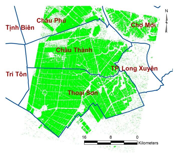
16 Ongoing research works Asia-RiCE&SAFE, GEORice Technical Demonstrator Site Mekong Delta, VN An Giang province, Mekong Delta, Vietnam Geographic coordinates: UL: 10 58'47.38"N, '39.51"E, UR:10 58'35.84"N, '12.84"E LR: 10 05'24.65"N, '15.36"E, LL: 10 05'45.13"N, '23.41"E 16
 Rice/Non-rice maps (P1)")
17 Methods SAR data Ground-truth data σ o of sampling fields Classification method Thresholding 24/03/07 In situ rice yield Regression analysis Regression equation Classification maps Asia-RiCE Target Agricultural Products Estimated rice yield distribution maps Accuracy assessment Reference data Ground data Estimated rice production (P5) Rice/Non-rice maps (P1) 17
 RADARSAT-2 data: - Band: C - Polarisation: VV&VH - Resolution: 10 m (Wide Fine) Sentinel-1 data: - Band: C")
18 Data set SAR data received: COSMO-SkyMed: Aug 2013 Feb 2014 RADARSAT-2: Aug 2013 Now Sentinel-1: Aug 2014 Now ALOS-2: Nov 2014 Now Rice crops monitored: 2013: AW; : WS, SA, AW. 18 COSMO-SkyMed data: - Band: X - Polarisation: HH&VV - Resolution: 20 m (StripMap PINGPONG) RADARSAT-2 data: - Band: C - Polarisation: VV&VH - Resolution: 10 m (Wide Fine) Sentinel-1 data: - Band: C - Polarisation: VV&VH - Resolution: 20 m (SW) ALOS-2 data: - Band: L - Polarisation: HH&HV - Resolution: 50 m (WS) & 12.5 m (Fine) Sentinel-1 6 October 2014
19 General parameters 19 Guidelines for ground data collection for rice monitoring experiments using radar data (Thuy Le Toan) Leaf parameters (optional) Panicle parameters Rice parameters Description Equipment Paddy variety Data set: CSK & RSAT-2, Ex.: IR Method of planting direct sowing/ transplanting Sowing date Transplanting date (if transplanting) Date of harvesting Yield (kg/m 2 ) date of direct sowing or number of days after sowing date of transplantation or the number of days after transplantation if the rice has been harvested if the rice have been harvested Seeding, transplanting, tillering, Plant phenological stage heading, flowering, ripening, ready to harvest Water layer height (cm) if fields are flooded stick Plant height (cm) above water layer tape Wet weight per m 2 (g) Dry weight per m 2 (g) Number of leaves per stem Leaf length (cm) Leaf width (cm) Moist and dry biomass of panicles per m 2 above water biomass (moist weight by m 2 ) cut all plants from defined areas (min 50 x 50 cm) objective is to measure the dry Oven dry (105 biomass per m 2 during 24 hours) Few samples for each sortie -Photo -Xerox copy of leaves
20 15.0 Data set: CSK, HH/VV (db) CSK_PP_ CSK_PP_ CSK_PP_ CSK_PP_ CSK_PP_ CSK_PP_ HH/VV (db) 20 TSX ( ) -5.0 CSK_PP_ CSK_PP_ CSK (2013) Days Ngày after sau sowing khi sạ TĐ2010_CM 4.0 ĐX2011_CM 2.0 ĐX2011_TL Số ngày sau sạ/cấy HH/VV (db) ASAR APP(2007) Days after sowing WS SA AW WS0 SA0 AW0


21 Data set: CSK, AW 2013 crop from CSK PP (20 Sep and 14 Oct 2013) Overall acc.: 89% Kappa: WS 2014 crop from CSK PP (11 Feb 2014)
22 Estimated area Agency data Percentage error Commune Name (ha) (ha) (%) An Bình 2,274 2, Bình Thành 2,313 2, Định Mỹ 3,178 2, Định Thành 2,613 2, Mỹ Phú Đông 2,676 2, Phú Thuận 1, Thoại Giang 2,203 2, Núi Sập Óc Eo Phú Hòa Vĩnh Khánh 2,500 2, Vĩnh Phú 3,069 3, Vĩnh Trạch 1,269 1, Vĩnh Chánh 2,357 1, Vọng Đông 2,601 2, Total 29,455 28, Data set: CSK, Agency data (ha) 3,500 3,000 2,500 2,000 1,500 1, Accuracy assessment of rice/non-rice mapping method for AW 2013 crop in Thoai Son district using two-date CSK data (20 Sep and 14 Oct) based on statistical data 0 y = x R² = ,000 1,500 2,000 2,500 3,000 3,500 Estimated area (ha)


23 Data set: CSK, AW 2007 crop from ASAR APP AW 2010 crop from ASAR APP AW 2013 crop from CSK PP

, 2013 crop at Chau Thanh and Thoai Son Ra 1 :")


24 Data set: CSK, Y Ra = *Ra *Ra *Ra 3 r 2 = 0.646, se y = 0.5 ton/ha Where: A distribution map of estimated rice yield in AW Y Ra : rice yield (ton/ha), 2013 crop at Chau Thanh and Thoai Son Ra 1 : polarisation ratio of first date image, districts using three-date polarisation ratios: Ra 2 : polarisation ratio of second date image, CSK 04 Sep 2013 Ra 3 : polarisation ratio of third date image, r 2 : the coefficient of determination, CSK 22 Oct 2013 se y : the standard error for the y estimate. CSK 07 Nov
25 Commune name 25 Estimated production (ton) Agency data (ton) Percentage error (%) Vinh Thanh 11,655 11, Vinh Nhuan 19,097 18, Vinh Loi 12,620 13, Hoa Binh Thanh 13,539 14, TT. An Chau 2,744 3, Binh Hoa 7,076 6, Vinh Binh 14,220 12, Vinh Hanh 14,653 15, Can Dang 12,688 12, An Hoa 3,048 2, Binh Thanh 14,028 13, Dinh My 19,492 17, Dinh Thanh 14,951 14, My Phu Dong 15,114 18, Phu Thuan 4,961 5, Thoai Giang 13,865 13, TT. Nui Sap 2,905 2, TT. Oc Eo 3,390 3, TT. Phu Hoa 1,436 1, Vinh Khanh 14,432 16, Vinh Phu 18,541 19, Vinh Trach 7,404 8, Vinh Chanh 11,538 12, Vong Dong 16,158 12, Total 269, , Estimated production (ton) Data set: CSK, y = x R² = Agency data (ton) Chau Thanh Thoai Son Accuracy assessment of estimated production for AW 2013 crop at Chau Thanh and Thoai Son district using three-date polarisation ratios (HH/VV) of CSK (04 Sep, 22 Oct, 07 Nov 2013) based on statistical data
26 Data set: RADARSAT-2, RADARSAT-2 data: - Band: C - Polarisation: VV&VH - Resolution: 10 m (Wide Fine)


27 Data set: RADARSAT-2, AW 2013 crop from RADARSAT-2 (29 Aug & 09 Nov 2013) AW 2013 crop from CSK PP (20 Sep & 14 Oct 2013) 27
28 Data set: RADARSAT-2, Accuracy assessment of rice/non-rice mapping method for AW 2013 crop in Thoai Son district using two-date RADARSAT-2 data (29 Aug & 9 Nov 2013) based on statistical data Commune name Estimated area (ha) Agency data (ha) Percentage error (%) RADARSAT-2, Thoai Son District - AW2013 An Binh 2,422 2, Binh Thanh 2,316 2, Đinh My 3,274 2, Đinh Thanh 2,743 2, My Phu Đong 2,828 2, Phu Thuan Tay Phu 1,936 2, Thoai Giang 2,349 2, Nui Sap Oc Eo Phu Hoa Vinh Khanh 2,545 2, Vinh Phu 3,213 3, Vĩnh Trach 1,303 1, Vinh Chanh 1,530 1, Vong Đong 2,620 2, Vong The 2,383 2, Total 32,875 33, Agency data (ha) 3,500 3,000 2,500 2,000 1,500 1, y = x R² = ,000 1,500 2,000 2,500 3,000 3,500 Estimated area (ha)

29 Data set: RADARSAT-2, 2016 District Agency data (ha) Estimated area (ha) Difference percentage (%) An Phu 13,640 13, Cho Moi 13,304 14, Chau Phu 34,940 30, Chau Thanh 28,630 26, Phu Tan 22,151 23, Tinh Bien 16,288 21, Chau Doc 6,315 6, Long Xuyen 4,518 3, Thoai Son 38,882 37, Tri Ton 42,210 38, Tan Chau 9,321 9, Total 230, , ,000 40,000 R² = 0.97 Estimated area (ha) 30,000 20,000 10, SA 2016 crop from RADARSAT-2 (15 Apr, 09 May, 02 Jun, 26Jun, 20 Jul & 13 Aug) ,000 20,000 30,000 40,000 50,000 Agency data (ha)


30 Data set: RADARSAT-2, A distribution map of estimated rice yield in AW 2013 crop at Chau Thanh and Thoai Son district using three-date VH polarisation: RADARSAT-2 29 Aug 2013 RADARSAT-2 16 Oct 2013 RADARSAT-2 09 Nov 2013 A distribution map of estimated rice yield in WS 2014 crop at Chau Thanh and Thoai Son district using three-date VH polarisation: RADARSAT-2 27 Dec 2013 RADARSAT-2 20 Jan 2014 RADARSAT-2 13 Feb


31 Data set: RADARSAT-2, A distribution map of estimated rice yield of An Giang in AW 2013 crop using RADARSAT-2 data
 200,000 150,000 100,000 50,000 0 0 50,000")

32 Data set: RADARSAT-2, ,000 R² = 0.97 A distribution map of estimated rice yield of An Giang in SA 2016 crop using RADARSAT-2 data Estimated production (ton) 200, , ,000 50, , , , , ,000 Agency data (ton) District Agency data (ton) Estimated production (ton) Difference percentage (%) 32 An Phú 73,656 68, Chợ Mới 77,296 77, Châu Phú 201, , Châu Thành 166, , Phú Tân 134, , Tịnh Biên 89, , Châu Đốc 37,890 32, Long Xuyên 29,503 16, Thoại Sơn 233, , Tri Tôn 229, , Tân Châu 54,994 53, Total 1,325,946 1,213,
 SA 2015 crop (using 4-date ALOS-2 HH image, 10/04, 22/05, 03/07 & 14/08/2015)")
33 Data set: ALOS-2, 2015 ALOS-2 data: - Band: L - Polarisation: HH&HV - Resolution: 50 m (WS) & 12.5 m (Fine) SA 2015 crop (using 4-date ALOS-2 HH image, 10/04, 22/05, 03/07 & 14/08/2015) 33

34 Data set: Sentinel-1, 2015 Sentinel-1 data: - Band: C - Polarisation: VV&VH - Resolution: 20 m (SW) Overall acc.: 93% Kappa: 0.97 WS 2015 crop (using 4-date S-1 image, 17/12/2014, 10/01, 27/02 & 04/04/2015) 34
35 Data set: Sentinel-1, 2016 District Agency data (ha) Estimated area (ha) Difference percentage (%) An Phu 13,640 10, Cho Moi 13,304 11, Chau Phu 34,940 32, Chau Thanh 28,630 25, Phu Tan 22,151 23, Tinh Bien 16,288 22, Chau Doc 6,315 6, Long Xuyen 4,518 3, Thoai Son 38,882 35, Tri Ton 42,210 41, Tan Chau 9,321 7, Total 230, , ,000 40,000 R² = Estimated area (ha) 30,000 20,000 SA 2016 crop (using S-1 images) 10, ,000 20,000 30,000 40,000 50,000 Agency data (ha)
36 Data set: Sentinel-1, 2016 SA 2016 crop (using S-1 images) SA 2016 crop (using R-2 images) 36


37 Data set: Sentinel-1, at regional scale Map of WS Rice 2015 Map of WS Rice Reduced area in 2016 caused by shortage of water and saline water intrusion
38 Data set: Sentinel-1, at regional scale 38 Rice area of Mekong Delta (1000 ha) Year WS Rice area (1000 ha)
39 Discussion Extend the target area and increase the observation frequency; Validation activities for the rice crop estimation; Number of fields: 100 rice fields and 30 non-rice points for each of the 3 regions Region 1: An Giang; Kien Giang; Can Tho Region 2: Dong Thap; Long An; Tien Giang Region 3: Soc Trang; Tra Vinh, Vinh Long Frequency: beginning, middle and end of season (3 times per rice season) Capacity building activities for end user. 39


40 VNREDSat-1 LOTUSAT
Adaptability Zoning for Salty-Tolerant Rice Varieties in Soc Trang Prefecture by Using GIS and Remote Sensing
 Journal of Geological Resource and Engineering 3 (2016) 142-150 doi:10.17265/2328-2193/2016.03.005 D DAVID PUBLISHING Adaptability Zoning for Salty-Tolerant Rice Varieties in Soc Trang Prefecture Tran
Lessons Learned: NAMA development in Vietnam
 Lessons Learned: NAMA development in Vietnam Dr. Huynh Thi Lan Huong Director of Climate Change Research Center Institute of Meteorology, Hydrology and Environment Ministry of Natural Resources and Environment,
CURRICULUM VITAE NAME NGUYEN HAI HOA. Living address: House N0. 24B, Group I, Tan Xuan, Xuan Mai town, Chuong My
 CURRICULUM VITAE NAME NGUYEN HAI HOA Sex: Male. Day of birth: 02 February 1974. Place of birth: Phuc Tho district, Ha Noi. Living address: House N0. 24B, Group I, Tan Xuan, Xuan Mai town, Chuong My District,
SAR data for forestry and agriculture
 SAR data for forestry and agriculture Thuy Le Toan September 5, 2007 Lecture D3L3 Assets of radar data for vegetation monitoring? All weather capability to secure data acquisition during growing season
AN OVERVIEW OF THE DRINKING WATER SUPPLY SITUATION IN THE MEKONG RIVER DELTA, VIETNAM
 AN OVERVIEW OF THE DRINKING WATER SUPPLY SITUATION IN THE MEKONG RIVER DELTA, VIETNAM Le Anh Tuan, M.Eng. WRE. College of Technology, CanTho University, Vietnam E-mail: latuan@ctu.edu.vn ------------------------------------------------------------------------------------------------------------
Vulnerability of Rice Production in Mekong River Delta under Impacts from Floods, Salinity and Climate Change
 Vol.5 (2015) No. 4 ISSN: 20885334 Vulnerability of Rice Production in Mekong River Delta under Impacts from Floods, Salinity and Climate Change Nguyen Ngoc Thuy #, Hoang Ha Anh * # Office of International
LIST OF CONSTRUCTION MATERIALS COMPANIES IN VIETNAM
 LIST OF CONSTRUCTION MATERIALS COMPANIES IN VIETNAM 1 COSEVSO 19 - Cement Company / Midland Construction Corporation Add: Hoa Khuong Commune, Hoa Vang District, Da Nang City Phone: 84-511-378 0329 Fax:
Overview of Water Environmental Pollution in Vietnam
 Overview of Water Environmental Pollution in Vietnam Nguyen Thi Hue Institute of Environmental Technology (IET), Vietnamese Academy of Science and Technology(VSAT). 18-Hoang Quoc Viet R., Caugiay distr.,hanoi,vietnam
Crop Mapping in the Hindu Kush Himalaya Region
 Crop Mapping in the Hindu Kush Himalaya Region Mir Matin Faisal Mueen Qamar Haqiq Rahmani Krishna Vadrevu Lee Ellenburg NASA ICIMOD Varun Tiwari Nabin Kumar Yadav Begum Rabeya Rushi MAIL, GIRoA Noorullah
Oxfam America (VIE 034/07): System of Rice Intensification -- Advancing Small Farmers in Mekong Region
: System of Rice Intensification -- Advancing Small Farmers in Mekong Region") DRAFT Oxfam America (VIE 034/07): System of Rice Intensification -- Advancing Small Farmers in Mekong Region Background Under a 3-year grant, SRI promotion is being implemented through a partnership among
DRAFT Oxfam America (VIE 034/07): System of Rice Intensification -- Advancing Small Farmers in Mekong Region Background Under a 3-year grant, SRI promotion is being implemented through a partnership among
MONITORING OF CROP GROWTH AND SOIL MOISTURE RETRIEVAL USING NISAR DATA. HARI SHANKER SRIVASTAVA Indian Institute of Remote Sensing (IIRS),
,") NISAR Science Workshop 2015 Space Applications Centre MONITORING OF CROP GROWTH AND SOIL MOISTURE RETRIEVAL USING NISAR DATA HARI SHANKER SRIVASTAVA Indian Institute of Remote Sensing (IIRS), Indian Space
NISAR Science Workshop 2015 Space Applications Centre MONITORING OF CROP GROWTH AND SOIL MOISTURE RETRIEVAL USING NISAR DATA HARI SHANKER SRIVASTAVA Indian Institute of Remote Sensing (IIRS), Indian Space
5. HYDROLOGICAL CONDITIONS IN THE MEKONG DELTA. 5.1 Key International Monitoring Stations in the Mekong Delta
 5. HYDROLOGICAL CONDITIONS IN THE MEKONG DELTA 5.1 Key International Monitoring Stations in the Mekong Delta 5.1.1 International Monitoring Stations from Phnom Penh to the Mekong Delta The Mekong River
Integration methods for forest degradation assessment and change monitoring
 VTT TECHNICAL RESEARCH CENTRE OF FINLAND LTD Joint GFOI / GOFC-GOLD / CONABIO / SilvaCarbon R&D Expert and Capacity Building workshop on: Regional solutions to forest type stratification and characterising
Vietnamese Real Estate - The potential market
 Vietnamese Real Estate - The potential market Currently, Vietnam is one of the fastest growing countries in the world. The investment trend is showing positively as the government continues to support
POTENTIAL IMPACTS OF THE SUPER SEA DYKE (SSD) AT RACH GIA BAY ON THE VALUES OF MANGROVES IN KIEN GIANG PROVINCE - MEKONG DELTA, VIETNAM
 AT RACH GIA BAY ON THE VALUES OF MANGROVES IN KIEN GIANG PROVINCE - MEKONG DELTA, VIETNAM") 1 POTENTIAL IMPACTS OF THE SUPER SEA DYKE (SSD) AT RACH GIA BAY ON THE VALUES OF MANGROVES IN KIEN GIANG PROVINCE - MEKONG DELTA, VIETNAM Dr. Trinh Thi Long SOUTHERN INSTITUTE OF WATER RESOURCES RESEARCH
1 POTENTIAL IMPACTS OF THE SUPER SEA DYKE (SSD) AT RACH GIA BAY ON THE VALUES OF MANGROVES IN KIEN GIANG PROVINCE - MEKONG DELTA, VIETNAM Dr. Trinh Thi Long SOUTHERN INSTITUTE OF WATER RESOURCES RESEARCH
Factors influencing the Vietnam Provincial Governance and Public Administration Performance Index (PAPI)
") Factors influencing the Vietnam Provincial Governance and Public Administration Performance Index (PAPI) By: Le Van Chien HCM National Academy of Politics and Public Administration, Vietnam This paper
Factors influencing the Vietnam Provincial Governance and Public Administration Performance Index (PAPI) By: Le Van Chien HCM National Academy of Politics and Public Administration, Vietnam This paper
Assessment of Flood Hazard in Hanoi City
 VNU Journal of Earth and Environmental Sciences, Vol. 29, No. 1 (2013) 26-37 Assessment of Flood Hazard in Hanoi City Nguyễn Hiệu *, Đỗ Trung Hiếu, Đặng Kinh Bắc, Đoàn Thu Phương * Faculty of Geography,
University of Agriculture & Forestry - Hue University. Châu Thành court, Cai Lậy court & Sắc Tứ pagoda, Tiền Giang
 No. PN Project title Implementing agency 1 6 2 8 3 10 4 18 5 22 6 34 7 40 8 44 9 47 Reducing greenhouse gases by promoting the use of "Advanced cooking table" model Development of environment-friendly
Farm Household Economic Management A case study at Tan Phu Thanh Village, Chau Thanh A District, Can Tho Province
 Farm Household Economic Management A case study at Tan Phu Thanh Village, Chau Thanh A District, Can Tho Province Nguyen Quang Tuyen 1, Ryuichi Yamada 2, Vo Van Tuan 1 and Le Canh Dung 1 1 : Mekong Delta
Integrated. Poverty Assessment for Livestock Policy. A Living from Livestock. FAO Seminar on HPAI FAO Resident Mission, Ha Noi 13 June 2006
 Integrated Poverty Assessment for Livestock Policy FAO Seminar on HPAI FAO Resident Mission, Ha Noi 13 June 2006 David Roland-Holst Joachim Otte & Saule Kazybayeva Contents 1. Poverty, Livestock & Livelihoods
Monitoring Crop Leaf Area Index (LAI) and Biomass Using Synthetic Aperture Radar (SAR)
 and Biomass Using Synthetic Aperture Radar (SAR)") Monitoring Crop Leaf Area Index (LAI) and Biomass Using Synthetic Aperture Radar (SAR) Mehdi Hosseini, Heather McNairn, Andrew Davidson, Laura Dingle-Robertson *Agriculture and Agri-Food Canada JECAM SAR
Monitoring Crop Leaf Area Index (LAI) and Biomass Using Synthetic Aperture Radar (SAR) Mehdi Hosseini, Heather McNairn, Andrew Davidson, Laura Dingle-Robertson *Agriculture and Agri-Food Canada JECAM SAR
STUDY AND APPLICATION OF CROP HARVESTING MECHANIZATION IN VIETNAM
 The 2 nd Session of the TC of APCAEM, November 20-21, 2006, Suwon, ROK STUDY AND APPLICATION OF CROP HARVESTING MECHANIZATION IN VIETNAM Dr. Nguyen Quoc Viet VIETNAM INSTITUTE OF AGRICULTURAL ENGINEERING
Compatibility of Alternate Wetting and Drying Irrigation with Local Agriculture in An Giang Province, Mekong Delta, Vietnam
 Trop. Agr. Develop. 61(3):117-127,2017 Compatibility of Alternate Wetting and Drying Irrigation with Local Agriculture in An Giang Province, Mekong Delta, Vietnam Takayoshi YAMAGUCHI 1, *, Minh Tuan LUU
The Flow of the Mekong
 MRC Management Information booklet series No. 2 The Flow of the Mekong November 2009 Meeting the needs, keeping the balance INTRODUCTION Integrated basin flow management (IBFM) is designed to provide information
Climate Change on the Vietnam, Mekong Delta
 Climate Change on the Vietnam, Mekong Delta Expected impacts and adaptations Toru Konishi World Bank East Asia Infrastructure Overview 1. The Mekong and the Mekong Delta 2. Expected Climate Change Impacts
institutional framework in Vietnam
 Mangrove-related policy and institutional framework in Vietnam MFF -FAO Final workshop for Income for Coastal Communities for Mangrove Protection Project December 2016 Dr. Mai Sy Tuan, MFF Vietnam NCB
Conference Title: 2016 CoRP Symposium. Author(s): Kristofer lasko, Colin Miller
: Kristofer lasko, Colin Miller") Conference Title: 2016 CoRP Symposium Author(s): Kristofer lasko, Colin Miller Title: A bottom-up approach to characterizing crop residue burning practices and estimating resultant emissions variations
Conference Title: 2016 CoRP Symposium Author(s): Kristofer lasko, Colin Miller Title: A bottom-up approach to characterizing crop residue burning practices and estimating resultant emissions variations
Impact of Climate Change on Rice Production in the Red River and Mekong River Delta of Vietnam
 Impact of Climate Change on Rice Production in the Red River and Mekong River Delta of Vietnam By Tran Van The*, Pham Quang Ha*, Bui Thi Phuong Loan* and Nguyen Hong Son** *Institute for Agricultural Environment,
Forest Biomass Change Detection Using Lidar in the Pacific Northwest. Sabrina B. Turner Master of GIS Capstone Proposal May 10, 2016
 Forest Biomass Change Detection Using Lidar in the Pacific Northwest Sabrina B. Turner Master of GIS Capstone Proposal May 10, 2016 Outline Relevance of accurate biomass measurements Previous Studies Project
IMPACT OF UPSTREAM HYDROPOWER DAMS AND CLIMATE CHANGE ON HYDRODYNAMICS OF VIETNAMESE MEKONG DELTA
 Journal of Japan Society of Civil Engineers, Ser. B (Hydraulic Engineering), Vol. 73, o. 4, I_9-I_4, 27. IMPACT OF UPSTREAM HYDROPOWER DAMS AD CLIMATE CHAGE O HYDRODYAMICS OF VIETAMESE MEKOG DELTA Sameh
WATER ENVIRONMENTAL GOVERNANCE IN THE MEKONG RIVER DELTA, VIETNAM
 WATER ENVIRONMENTAL GOVERNANCE IN THE MEKONG RIVER DELTA, VIETNAM Le Anh Tuan 1,2) and Guido Wyseure 2) 1) Department of Environmental and Water Resources Engineering, College of Technology Can Tho University,
THÔNG TIN GIẢNG VIÊN
 BETTER WORK VIETNAM THÔNG TIN GIẢNG VIÊN Giảng viên Nguyễn Thanh Thủy trưởng, Kỹ năng quản lý cho quản lý cấp trung, Hợp tác và truyền thông hiệu quả tại nơi làm việc, Kỹ năng thương lượng và Phòng tránh
ENVIRONMENTAL IMPACTS ASSESSMENT REPORT
 SOCIALIST REPUBLIC OF VIETNAM BENTRE PROVINCIAL PEOPLE'S COMMITTEE BEN TRE WATER MANAGEMENT PROJECT (B-SWAMP) ENVIRONMENTAL IMPACTS ASSESSMENT REPORT 2016 SOCIALIST REPUBLIC OF VIETNAM BENTRE PROVINCIAL
A REVIEW OF FOREST FIRE INFORMATION TECHNOLOGIES IN VIETNAM
 A REVIEW OF FOREST FIRE INFORMATION TECHNOLOGIES IN VIETNAM Le Thanh Ha 1, Nguyen Hai Chau 1, Nguyen Hoang Nam 1, Bui Quang Hung 1, Nguyen Thi Nhat Thanh 1, Nguyen Ba Tung 1, Do Khac Phong 1, Nguyen Van
MID TERM REPORT. Completion of Pilot Investment Project Improved Cook Stove Use in Viet Nam. Revision: 01. Submitted to: Landell Mills Ltd.
 EPRO CONSULTING JSC CENTRE FOR SOCIAL INNITIATIVES PROMOTION MID TERM REPORT Completion of Pilot Investment Project Improved Cook Stove Use in Viet Nam Revision: 01 Submitted to: Landell Mills Ltd. Hanoi
MINISTRY OF AGRICULTURE AND RURAL DEVELOPMENT (MARD) PROJECT PREPARATION UNIT (PPU) VOLUME 4. (Final Report) PREPARED BY
 PROJECT PREPARATION UNIT (PPU) VOLUME 4. (Final Report) PREPARED BY") Public Disclosure Authorized Public Disclosure Authorized Public Disclosure Authorized Public Disclosure Authorized MINISTRY OF AGRICULTURE AND RURAL DEVELOPMENT (MARD) PROJECT PREPARATION UNIT (PPU) ENVIRONMENTAL
Public Disclosure Authorized Public Disclosure Authorized Public Disclosure Authorized Public Disclosure Authorized MINISTRY OF AGRICULTURE AND RURAL DEVELOPMENT (MARD) PROJECT PREPARATION UNIT (PPU) ENVIRONMENTAL
CONSUMPTION OF FOODSTUFF FROM ANIMAL ORIGIN AND CONSUMERS UNDERSTANDING ON FOOD SAFETY: CASE STUDY IN RED RIVER DELTA
 CONSUMPTION OF FOODSTUFF FROM ANIMAL ORIGIN AND CONSUMERS UNDERSTANDING ON FOOD SAFETY: CASE STUDY IN RED RIVER DELTA Vu Dinh Ton 1, Pham Kim Dang 2 et al 1 Center for Interdisciplinary Research on Rural
Integration of SAR multi-frequency and optical data for the retrieval of soil moisture and vegetation water content
 Integration of SAR multi-frequency and optical data for the retrieval of soil moisture and vegetation water content A. Padovano 1,2, F. Greifeneder 1, R. Colombo 2, G. Cuozzo 1, C. Notarnicola 1 1 - Eurac
GEO-DRI Drought Monitoring Workshop, May 10-11, 2010, Winnipeg, Manitoba Drought in Southeast Asia
 GEO-DRI Drought Monitoring Workshop, May 10-11, 2010, Winnipeg, Manitoba Drought in Southeast Asia Orn-uma Polpanich Stockholm Environment Institute Asia Bangkok, Thailand Southeast Asia Is located on
#24. Singapore 18 May Vietnam s Leadership Transition in 2016: A Preliminary Analysis. By Le Hong Hiep* EXECUTIVE SUMMARY
 ISSN 2335 6677 #24 2015 Singapore 18 May 2015 Vietnam s Leadership Transition in 2016: A Preliminary Analysis By Le Hong Hiep* EXECUTIVE SUMMARY The 12 th national congress of the Communist Party of Vietnam
2013 SWAT CONFERENCE Toulouse, France, July 17-19, 2013
 7/19/2013 2013 SWAT CONFERENCE Toulouse, France, July 17-19, 2013 Nguyen Kim Loi (1), Nguyen Duy Liem (1), Pham Cong Thien (1), Le Van Phan (1), Le Hoang Tu (1), Hoang Thi Thuy (1), Nguyen Van Trai (1),
Assessment of the efficiency of organic amendments in coastal sandy soil area of Thua Thien Hue province, Central Vietnam
 Assessment of the efficiency of organic amendments in coastal sandy soil area of Thua Thien Hue province, Central Vietnam Hoang Thi Thai Hoa, Pham Khanh Tu 1, Pham Quang Ha 2, Cl.N. Chiang and J.E. Dufey
FOREST AND FOREST CHANGE MAPPING WITH C- AND L-BAND SAR IN LIWALE, TANZANIA
 FOREST AND FOREST CHANGE MAPPING WITH C- AND L-BAND SAR IN LIWALE, TANZANIA J. Haarpaintner a, C. Davids a, H. Hindberg a, E. Zahabu b, R.E. Malimbwi b a Norut, P.O. Box 6434, Tromsø Science Park, N-9294
Da Nang, Vietnam. Dr. Dang Quang Vinh, Manager Da Nang Environmental Protection Agency
 Da Nang, Vietnam Dr. Dang Quang Vinh, Manager Da Nang Environmental Protection Agency The 2 nd Workshop APEC Low-Carbon Model Town Task Force 10 May 2016 Da Nang City Area: 1,285 km 2. Population: 1.008
The South/Southeast Asia Research Initiative (SARI) Update and Meeting Objectives. Krishna Prasad Vadrevu NASA Marshall Space Flight Center
 Update and Meeting Objectives. Krishna Prasad Vadrevu NASA Marshall Space Flight Center") The South/Southeast Asia Research Initiative (SARI) Update and Meeting Objectives Krishna Prasad Vadrevu NASA Marshall Space Flight Center Presentation topics Background to the SARI initiative Meeting
The South/Southeast Asia Research Initiative (SARI) Update and Meeting Objectives Krishna Prasad Vadrevu NASA Marshall Space Flight Center Presentation topics Background to the SARI initiative Meeting
Shinichi Sobue, Kei Oyoshi, Lam Dao Nguyen and K.R. Manjunath. On behalf of Asia RiCE team in GEOGLAM
 ASIA RICE CROP TEAM (ASIA-RICE) ACTIVITY IN GEO GLAM Shinichi Sobue, Kei Oyoshi, Lam Dao Nguyen and K.R. Manjunath On behalf of Asia RiCE team in GEOGLAM 1 Asia-RiCE for GEOGLAM (Global Agriculture Monitoring)
# Group STT COMPANY / ORGAN BUSINESS SCOPES / OBLIGATIONS. Vietnam Chamber of Commerce and Industry
 # STT COMPANY / ORGAN BUSINESS SCOPES / OBLIGATIONS 1 Vietnam Chamber of Commerce and Industry www.vcci.com.vn E-commerce, Business training programs, Trade & Investment promotion, Linking enterprises
Adapted Technologies for a Sustainable Protection of Water and Land Resources in the Southern Mekong Delta German Science Day 2017
 Adapted Technologies for a Sustainable Protection of Water and Land Resources in the Southern Mekong Delta German Science Day 2017 20 years of Science & Technology Cooperation between Vietnam and Germany
IN NORTH CENTRAL COAST, VIETNAM Overview
 EMISSION REDUCTION PROGRAM IN NORTH CENTRAL COAST, VIETNAM Overview CF 17 Meeting Paris, 30 January 2018 Alignment with National Priorities & Commitment VN expresses strong political commitment to CC (UNFCCC,
VIETNAM GROUP: Dr. Nguyen Thanh Hai. Deputy Dean of Faculty of Engineering, Vietnam National University of Agriculture
 VIETNAM GROUP: Dr. Nguyen Thanh Hai Deputy Dean of Faculty of Engineering, Vietnam National University of Agriculture Email: nthai@vnua.edu.vn Ms. Dinh Thi Tam Deputy Director, Vietnam Institute of Agricultural
Reforestation in grassland areas of Uchindile, Kilombero, Tanzania & Mapanda, Mufindi, Tanzania
 Reforestation in grassland areas of Uchindile, Kilombero, Tanzania & Mapanda, Mufindi, Tanzania Biodiversity Monitoring Results 2 nd September 2012 to 31 st December 2013 18 th August 2014 Version 1 1
IOP Conference Series: Earth and Environmental Science. Related content PAPER OPEN ACCESS
 IOP Conference Series: Earth and Environmental Science PAPER OPEN ACCESS Monitoring spatial and temporal variations of the rice backscatter coefficient (σ 0 ) at different phenological stages in Sungai
Effects of Paddy Field conversion to urban use on watershed hydrology in Southern China
 Effects of Paddy Field conversion to urban use on watershed hydrology in Southern China Di Fang, Mengsheng Qin, Hong Qian, Lei Sun, Lu Hao Nanjing University of Information Science and Technology Background
ScienceDirect. The Main Causes of Land Subsidence in Ho Chi Minh City
 Available online at www.sciencedirect.com ScienceDirect Procedia Engineering 142 (2016 ) 334 341 Sustainable Development of Civil, Urban and Transportation Engineering Conference The Main Causes of Land
 FP7- SPA.2013.1.1-06: Stimulating development of downstream services and service evolution. Contract N : 606983 A downstream service to support agro-production, planning and policy http://www.ermes-fp7space.eu/
G R O W I N G W I T H E F F E C T I V E D I S T R I B U T I O N E X PA N S I O N
 G R O W I N G W I T H E F F E C T I V E D I S T R I B U T I O N E X PA N S I O N BY TARGETING TOP 20 PROVINCES BY NIELSEN SALESFORCE ACTIVATION TEAM - Nov 2016 1 THE OPPORTUNITIES Traditional trade is
AGRICULTURAL PERFORMANCE MONITORING WITH POLARIMETRIC SAR AND OPTICAL IMAGERY
 AGRICULTURAL PERFORMANCE MONITORING WITH POLARIMETRIC SAR AND OPTICAL IMAGERY Tishampati Dhar [1][2], Doug Gray [1], Carl Menges [2] [1] Dept of Electrical and Electronic Engineering, University of Adelaide,
LONG AN PROVINCE. 1 Basic information 1
 LONG AN PROVINCE 1 Basic information 1 1.1 Geography 2 Long An Province is a connecting point for Ho Chi Minh City (HCMC), the largest economic and cultural centre of Vietnam, in the north with some Mekong
Education, Research, Training and Capacity Building Activities in AIT
 Education, Research, Training and Capacity Building Activities in AIT (Research & Training Node for Sentinel Asia) Manzul Hazarika Ph.D. Associate Director, Geoinformatics Center Asian Institute of Technology
ECONOMIC ANALYSIS ON PRODUCTION OF HIGH QUALITY RICE IN CUULONG DELTA, VIETNAM
 Omonrice 17: 174-178 (2010) ECONOMIC ANALYSIS ON PRODUCTION OF HIGH QUALITY RICE IN CUULONG DELTA, VIETNAM ABSTRACT Rice is the principal food for about half of the world s population. Rice consumption
15. Population Ecology and Management of Rodent Pests in the Mekong River Delta, Vietnam
 15. Population Ecology and Management of Rodent Pests in the Mekong River Delta, Vietnam Peter R. Brown, Nguyen Quy Hung, Nguyen Manh Hung and Monica van Wensveen Abstract Rodent pests are a growing problem
Intersection of SAR imagery with medium resolution DEM for the estimation of regional water storage changes
 Intersection of SAR imagery with medium resolution DEM for the estimation of regional water storage changes Sonya Spiridonova 1, Karin Hedman 1, Florian Seitz 2 1 Earth Oriented Space Science and Technology
The role of Remote Sensing in Irrigation Monitoring and Management. Mutlu Ozdogan
 The role of Remote Sensing in Irrigation Monitoring and Management Mutlu Ozdogan Outline Why do we care about irrigation? Remote sensing for irrigated agriculture What are the needs of irrigators? Future
UN-EU GUIDELINES FOR FINANCING OF LOCAL COSTS IN DEVELOPMENT CO-OPERATION WITH VIET NAM. Version 2013
 UN-EU GUIDELINES FOR FINANCING OF LOCAL COSTS IN DEVELOPMENT CO-OPERATION WITH VIET NAM Version 2013 ISSUED BY UN AGENCIES IN VIET NAM, THE EU DELEGATION TO VIET NAM AND THE MINISTRY OF PLANNING AND INVESTMENT
ESTIMATION OF RICE GROWTH PARAMETER AND CROP PHENOLOGY WITH CONJUNCTIVE USE OF RADARSAT AND ENVISAT
 ESTIMATION OF RICE GROWTH PARAMETER AND CROP PHENOLOGY WITH CONJUNCTIVE USE OF RADARSAT AND ENVISAT Indrani Choudhury, M.Chakraborty and J.S. Parihar Remote Sensing Applications and Image Processing Area
REPORT ON FINAL WORKSHOP AND TRAINING COURSE ON NANO SAFETY IN VIETNAM Hanoi, 5-6 May 2016
 Organization REPORT ON FINAL WORKSHOP AND TRAINING COURSE ON NANO SAFETY IN VIETNAM Hanoi, 5-6 May 2016 Within the Memorandum of Agreement on "Training and Capacity building to develop pilot projects on
Forest Changes and Biomass Estimation
 Forest Changes and Biomass Estimation Project Title: Comparative Studies on Carbon Dynamics in Disturbed Forest Ecosystems: Eastern Russia and Northeastern China Supported by NASA Carbon Cycle Science
Ecosystems and Their Services in Da Bac District, Hoa Binh Province
 VNU Journal of Science: Natural Sciences and Technology, Vol. 32, No. 1S (2016) 48-55 Ecosystems and Their Services in Da Bac District, Hoa Binh Province Nguyen Van Hien, Nguyen Thi Ngoc Mai, Nghiem Thi
Monitoring, Assessment, Prediction and Meteorological service of Agricultural Drought in China
 Monitoring, Assessment, Prediction and Meteorological service of Agricultural Drought in China Wang Shili China Meteorological Administration January, 2005, Kobe Content Characteristics of agrometerological
Combining Moderate-Resolution Time-Series RS Data from SAR and Optical Sources for Rice Crop Characterisation: Examples from Bangladesh
 Chapter 4 Combining Moderate-Resolution Time-Series RS Data from SAR and Optical Sources for Rice Crop Characterisation: Examples from Bangladesh Andrew Nelson, Mirco Boschetti, Giacinto Manfron, Franceco
30 Years of Tree Canopy Cover Change in Unincorporated and Incorporated Areas of Orange County,
 30 Years of Tree Canopy Cover Change in Unincorporated and Incorporated Areas of Orange County, 1986-2016 Final Report to Orange County July 2017 Authors Dr. Shawn Landry, USF Water Institute, University
THE SUPPLY CHAIN OF FERTILIZER IN SOUTH VIETNAM A CASE STUDY
 THE SUPPLY CHAIN OF FERTILIZER IN SOUTH VIETNAM A CASE STUDY Stenberg, A. Accenture Drammensvn. 165 N-0212 Oslo, Norway are.stenberg@accenture.com Lundestad, H. Wilh.Wilhelmsen ASA Strandvn. 20, N-1324
Land Use/Land Cover Change Research and Management in Vietnam
 NASA-LCLUC Science Team Joint Meeting with MAIRS, GOFCGOLD and SEA START on LC/LU Change Processes in Monsoon Asia Region Jan.12-17, 2009 Land Use/Land Cover Change Research and Management in Vietnam By:
SCOPE FOR RENEWABLE ENERGY IN HIMACHAL PRADESH, INDIA - A STUDY OF SOLAR AND WIND RESOURCE POTENTIAL
 SCOPE FOR RENEWABLE ENERGY IN HIMACHAL PRADESH, INDIA - A STUDY OF SOLAR AND WIND RESOURCE POTENTIAL Gautham Krishnadas and Ramachandra T V Energy & Wetlands Research Group, Centre for Ecological Sciences,
DMC 22m Sensors for Supertemporal Land Cover Monitoring. Gary Holmes DMC International Imaging Ltd June 2014
 DMC 22m Sensors for Supertemporal Land Cover Monitoring Gary Holmes DMC International Imaging Ltd June 2014 DMC 2 nd Generation Satellites UK-DMC2 and Deimos-1 launched 29 th July 2009 650km swath width
Community Carbon Accounting Action Research Project Vietnam
 Community Carbon Accounting Action Research Project Vietnam Activity Report FY2012 Makino Yamanoshita, Hoang Ngoc Y, and Nguyen The Dung This report is made available to share information on the Community
Utilization of the SWAT Model and Remote Sensing to Demonstrate the Effects of Shrub Encroachment on a Small Watershed
 Utilization of the SWAT Model and Remote Sensing to Demonstrate the Effects of Shrub Encroachment on a Small Watershed Jason Afinowicz Department of Biological and Agricultural Engineering Texas A&M University
CONTRIBUTORS 6/30/14. Major crops in Bangladesh. CDB strategy for cotton expansion
 // CONTRIBUTORS MD. FAKHRE ALAM IBNE TABIB, PhD DEPUTY DIRECTOR COTTON DEVELOPMENT BOARD DHAKA REGION, DHAKA. Dr. Md. Fakhre Alam Ibne Tabib, Deputy Director, CDB Prof. Dr. M. Abdul Karim, Department of
Water balance of savannah woodlands: a modelling study of the Sudanese gum belt region
 Department of Forest Sciences/ VITRI Faculty of Agriculture and Forestry Water balance of savannah woodlands: a modelling study of the Sudanese gum belt region Syed Ashraful Alam (Ashraful.Alam@helsinki.fi)
VIETNAM HOSPITALITY INDUSTRY ON THE WAY OF SUSTAINABLE WATER USE
 MINISTRY OF CULTURE, SPORTS AND TOURISM VIETNAM NATIONAL ADMINISTRATION OF TOURISM VIETNAM HOSPITALITY INDUSTRY ON THE WAY OF SUSTAINABLE WATER USE December 2017 Phuket, Thailand 1 Hoạt động Cơ sở lưu
THE RETAIL MARKET OF MEKONG DELTA KEY ECONOMIC REGION IN INTERNATIONAL INTEGRATION TREND
 THE RETAIL MARKET OF MEKONG DELTA KEY ECONOMIC REGION IN INTERNATIONAL INTEGRATION TREND Abstract DINH Tien Minh University of Economics Ho Chi Minh City dinhtienminh@ueh.edu.vn PHAM Thi Truc Ly University
Hydro-climatic modelling workshop UNSW - MDB Water policy challenges and innovation
 Hydro-climatic modelling workshop UNSW - MDB Water policy challenges and innovation Presenter: Jason Alexandra Director Water Policy Coordination April 2009 Overview 1. Background 2. Challenges 3. Brief
Soil Temperature Damping Depth in Boreal Plain Forest Stands and Clear Cuts: Comparison of Measured Depths versus Predicted based upon SWAT Algorithms
 Soil Temperature Damping Depth in Boreal Plain Forest Stands and Clear Cuts: Comparison of Measured Depths versus Predicted based upon SWAT Algorithms G. Putz and B.M. Watson Civil & Geological Engineering,
Radar Polarimetry for Forestry Applications: ALOS and Radarsat-2 studies in Canada
 Radar Polarimetry for Forestry Applications: ALOS and Radarsat-2 studies in Canada by S. R. Cloude (1), A. Marino (2), D. Goodenough (3), H Chen (3), A. Richardson (3), B. Moa (4) (1) AEL Consultants,
VALUE CHAIN INITIATIVES FOR DRAGON FRUIT (PITAYA) MARKET DEVELOPMENT
 MARKET DEVELOPMENT") VALUE CHAIN INITIATIVES FOR DRAGON FRUIT (PITAYA) MARKET DEVELOPMENT John Malcolm Campbell 1 Nguyen Van Hoa 2, Nguyen Minh Chau 2, and Nguyen Huu Hoang 2 1 New Zealand Institute of Plant and Food Research
VALUE CHAIN INITIATIVES FOR DRAGON FRUIT (PITAYA) MARKET DEVELOPMENT John Malcolm Campbell 1 Nguyen Van Hoa 2, Nguyen Minh Chau 2, and Nguyen Huu Hoang 2 1 New Zealand Institute of Plant and Food Research
Rainwater Management. Dr. Iftikhar Ahmad. College of Earth and. University of The Punjab Lahore
 Rainwater Management in Major Cities of Punjab Dr. Iftikhar Ahmad College of Earth and Environmental Sciences. University of The Punjab Lahore Need For Rainfall Harvesting in Urban Areas of Punjab Groundwater
GEOGLAM international cooperation activities
 GEOGLAM international cooperation activities Chris Justice Center for Global Agricultural Monitoring and Research Dept. of Geographical Sciences University of Maryland GEO: an International Coordinating
Application of PALSAR data to classify vegetation in an anthropogenically affected wetland area in Central Spain (Las Tablas de Daimiel)
") Rhodes, Greece, Application of PALSAR data to classify vegetation in an anthropogenically affected wetland area in Central Spain (Las Tablas de Daimiel) Thomas Schmid 1, Magaly Koch 2, Jesús Solana 3 and
Rhodes, Greece, Application of PALSAR data to classify vegetation in an anthropogenically affected wetland area in Central Spain (Las Tablas de Daimiel) Thomas Schmid 1, Magaly Koch 2, Jesús Solana 3 and
M.L. Kavvas, Z. Q. Chen, M. Anderson, L. Liang, N. Ohara Hydrologic Research Laboratory, Civil and Environmental Engineering, UC Davis
 Assessment of the Restoration Activities on Water Balance and Water Quality at Last Chance Creek Watershed Using Watershed Environmental Hydrology (WEHY) Model M.L. Kavvas, Z. Q. Chen, M. Anderson, L.
Summary of the socio-economic impact of Copernicus in the EU
 Summary of the socio-economic impact of Copernicus in the EU ESA Since the entry into service of Copernicus first satellite, Sentinel-1A, in 2014, the impacts of the programme are witnessed beyond the
Village Baseline Study: Site Analysis Report for Ma village Yen Binh district, Vietnam (VN01)
") CGIAR Research Program on Climate Change, Agriculture and Food Security (CCAFS) Village Baseline Study: Site Analysis Report for Ma village Yen Binh district, Vietnam (VN01) November 2015 Do Trong Hieu,
CGIAR Research Program on Climate Change, Agriculture and Food Security (CCAFS) Village Baseline Study: Site Analysis Report for Ma village Yen Binh district, Vietnam (VN01) November 2015 Do Trong Hieu,
The Classification of Farming Systems in Alluvial Soil Area of the Mekong Delta
 The Classification of Farming Systems in Alluvial Soil Area of the Mekong Delta Ryuichi Yamada 1, Vo Quang Minh 2, Nguyen Quang Tuyen 3, Le Canh Dung 3 and Vo Van Tuan 3 1: Japan International Research
Joint GFOI/GOFC-GOLD Expert Workshop 2: Approaches to monitoring forest degradation for REDD+
 Joint GFOI/GOFC-GOLD Expert Workshop 2: Approaches to monitoring forest degradation for REDD+ Forest carbon monitoring for REDD MRV with satellite 3D SAR Svein Solberg Norwegian Forest and Landscape Institute
Polar Space Task Group Permafrost Review of Requirements, Achievements and Expected Data
 Polar Permafrost Review of Requirements, Achievements and Expected Data Annett Bartsch Central Institute for Meteorology and Geodynamics, Vienna, Austria PSTG 6, ESTEC, Sept., 2016 Developments since last
Foliar Nutrition: an Extra Bonus for the Rice Grower. Yoav Ronen, Joshua Golovaty and Eran Barak, Haifa group
 Foliar Nutrition: an Extra Bonus for the Rice Grower Yoav Ronen, Joshua Golovaty and Eran Barak, Haifa group Foliar Nutrition- an extra Bonus for the rice grower About 80 million ha of irrigated lowland
Vulnerability to Climate Change Related Water Resource Changes and Extreme Hydrological Events in Southeast Asia
 Vulnerability to Climate Change Related Water Resource Changes and Extreme Hydrological Events in Southeast Asia A Final Report Submitted to Assessments of Impacts and Adaptations to Climate Change (AIACC),
REFORESTATION AND AFFORESTATION OF MANGROVES IN VIETNAM
 Page 1 of 5 PROCEEDINGS OF THE NATIONAL WORKSHOP REFORESTATION AND AFFORESTATION OF MANGROVES IN VIETNAM Can Gio, Ho Chi Minh City, 6-8 August 1994 Sponsored by Action for Mangrove Reforestation, Japan