Satellite image classification of vegetation and surface water for assessment of flood damage to agricultural crops
|
|
|
- Randolf Jefferson
- 6 years ago
- Views:
Transcription
1 Satellite image classification of vegetation and surface water for assessment of flood damage to agricultural crops Lisa Colson 2, Mark Lindeman 1, Dath Mita 1, Tatiana Nawrocki 2, Paulette Sandene 1, Christianna Townsend 2 1. International Production Assessment Division, Office of Global Analysis, Foreign Agricultural Service, United States Department of Agriculture 2. Inuteq, LLC
2 Satellite Monitoring of Global Agriculture Each month, the U.S. Department of Agriculture (USDA) publishes crop supply and demand estimates for the Nation and the world. Satellite imagery analysis performed by the International Production Assessment Division (IPAD) of Foreign Agricultural Service (FAS) contributes to the accuracy and reliability of forecasts. Floods and other natural disasters can abruptly change regional or global production outlook. Satellite imagery analysis assists in obtaining near-real time production damage estimates in remote regions before other local estimates become available.


3 Flood impacts on crops depend on crop calendar, flood duration and size Ancient Egypt would not have existed without preseasonal Nile River floods. Floods can destroy plants if occurred during growing seasons

4 How to quantify flood damage to agriculture remotely? Objective: Identify and overlay outlines of flood water and active agricultural crops Method: Satellite imagery time series analysis and classification Case studies: 2013 floods in Russia, China, Pakistan


 bands 7-2-1")
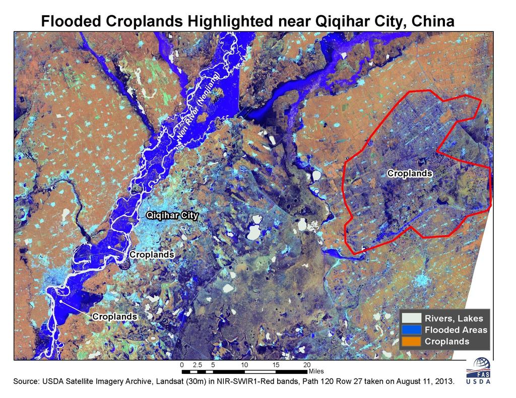
5 Flooding on the Nenjiang and Songhua Rivers in Heilongjiang, China 2013 flood Non-flood year Multiple dates of MODIS imagery were classified to estimate the flood extent without errors from clouds and cloud shadows Qiqihar Qiqihar Source: USDA GLAM Project, MODIS Terra satellite (250m) bands taken on August 13th.
6
")


7 Estimated Area Flooded (hectares) Field Crops 1.2 million ha Rice Crops 60,000 ha (Only 4% of the 2011 sown area)


8 Flood in Amur oblast, Russia July 16, 2013 Flood August 21, 2013 Before flood Data source: MODIS Terra, bands

9 Preliminary estimate GIS overlay: 2013 flood and historic crop map, Amur oblast


10 Verify vegetation classification results 2011crop statistics vs classified image results 2013 flood water, classified crop area and % of flooded crops 2013
11 Distinguish flood and irrigation waters When floods occurred concurrently with irrigation, an overlay of pre-flood vegetation and water areas did not correctly quantify the flood damaged crop area. Irrigated fields, which were initially classified as water, turned to productive crops later in the season.
12 Torrential rains coincided with irrigation season, early August, 2013, Sind, Pakistan Irrigation 2013 Flood water passed through irrigation systems, partially inundated fields, then spilled to drainage network. Afghanistan Baluchistan Punjab Sindh India

13 Before flood, July 10 After flood, August 27 Water on the fields


14 Landsat time series Multispectral LS images compounded as 30+ band image stack? Image time series allowed to see water and vegetation almost like in motion.

15 Normalized Difference Vegetation Index (NDVI) (NIR - Red) (NIR + Red) 50% % 0.14 ( )/( ) = 0.14 Synthetic signatures of a temporal NDVI image stack simulate crop performance during vegetation cycle and surface water stages in each pixel. ( )/( ) = 0.72
 NDVI time")


16 NDVI time series (from Landsat) NDVI time series show water and vegetation almost like in motion. Multi-temporal image stack classification located water, healthy and flood damaged crops.
17 Time series classification goals Well performing crops Flooded crops Non-agricultural vegetation Irrigated land Flooded non-cropland Permanent surface water bodies

18 Crop locations and crop cycle Typical NDVI cycles in predominantly rice cultivation regions Typical NDVI cycles in predominantly cotton cultivation regions Rice irrigation and transplanting, July - August Cotton planting, May - June


19 Image classification: spectral bands vs. temporal layers Spectral, 8/27/2013 Single day vegetation and other land cover types based on spectral profiles Seasonal vegetation performance based on NDVI time series Temporal July August September October


20 Interpret class metrics and locate crops Right Indus bank: dominant rice Left Indus bank: dominant cotton

21 NDVI time series classification results: Mapping vegetation performance Similar to rice Similar to cotton Afghanistan Baluchistan Punjab Sindh India Poor / stressed Vegetation performance types during the crop cycle Water and bare land classes have been removed


22 Results: crop performance map and calculating areas by performance categories Class Pixels Percent Sq. meter Hectare 1 810, % 729,693,000 72, , % 558,584,100 55, , % 409,094,100 40, , % 348,489,000 34, , % 314,411,400 31, , % 603,616,500 60, , % 699,317,100 69, ,006, % 906,156,900 90, , % 606,809,700 60, , % 392,542,200 39,254 Other 3,669, % 3,302,368, ,237 Quantify and compare areas of well performing and damaged crops.
23 NDWI Time Series Normalized Difference vegetation Water content Index NDWI (NIR SWIR) (NIR + SWIR)


24 NDWI time series classification detected permanent and flood water July 10 August 27 Sept. 12 Sept. 28
25 Image classification detected: Well performing crops Flooded crops Other (native) vegetation Irrigated land Flooded non-cropland Permanent surface water Disclaimer: Interpretation of the results was based on assumptions about the crop cycle. Ground truth data were not available. The contents contained in this presentation do not necessarily reflect the work and/or opinions of the USDA and its authorities.
Ukraine Winter Wheat: Sowing Progress (All years include estimated area for Crimea.)
") Sept 7 Sept 14 Sept 21 Sept 28 Oct 5 Oct 12 Oct 19 Oct 26 Nov 2 Nov 9 Nov 16 Million hectares 1,000 hectares 8,000 7,000 6,000 Ukraine Winter Wheat: Sowing Progress (All years include estimated area for
Sept 7 Sept 14 Sept 21 Sept 28 Oct 5 Oct 12 Oct 19 Oct 26 Nov 2 Nov 9 Nov 16 Million hectares 1,000 hectares 8,000 7,000 6,000 Ukraine Winter Wheat: Sowing Progress (All years include estimated area for
To provide timely, accurate, and useful statistics in service to U.S. agriculture
 NASS MISSION: To provide timely, accurate, and useful statistics in service to U.S. agriculture What does NASS do? Administer USDA s Statistical Estimating Program Conduct the 5-year Census of Agriculture
Crop Mapping in the Hindu Kush Himalaya Region
 Crop Mapping in the Hindu Kush Himalaya Region Mir Matin Faisal Mueen Qamar Haqiq Rahmani Krishna Vadrevu Lee Ellenburg NASA ICIMOD Varun Tiwari Nabin Kumar Yadav Begum Rabeya Rushi MAIL, GIRoA Noorullah
The role of Remote Sensing in Irrigation Monitoring and Management. Mutlu Ozdogan
 The role of Remote Sensing in Irrigation Monitoring and Management Mutlu Ozdogan Outline Why do we care about irrigation? Remote sensing for irrigated agriculture What are the needs of irrigators? Future
Crop Information Portal Agriculture Information System Building Provincial Capacity for Crop Forecasting and Estimation
 International Conference on Innovative Agricultural Financing April 28-29, 2015 at Hotel Serena Islamabad Day 1 Tuesday 28 April 2015 Session B: Digital platforms in building data-ecosystem for agri-finance
Remote sensing technology contributes towards food security of Bangladesh
 American Journal of Remote Sensing 2013; 1(3): 67-71 Published online June 20, 2013 (http://www.sciencepublishinggroup.com/j/ajrs) doi: 10.11648/j.ajrs.20130103.12 Remote sensing technology contributes
India. India Grain Voluntary Update - October 2017
 THIS REPORT CONTAINS ASSESSMENTS OF COMMODITY AND TRADE ISSUES MADE BY USDA STAFF AND NOT NECESSARILY STATEMENTS OF OFFICIAL U.S. GOVERNMENT POLICY Voluntary - Public Date: 10/3/2017 GAIN Report Number:
SOUTHERN INDIANA 2008 FLOODS: DAMAGE ASSESSMENT AND WEB MAPPING
 SOUTHERN INDIANA 2008 FLOODS: DAMAGE ASSESSMENT AND WEB MAPPING Ejaz Hussain KyoHyouk kkim Jie Shan, Associate Professor {ehussain,kim458,jshan}@,j purdue.edu Tel:765-494-2168 School Of Civil Engineering
EVALUATING THE ACCURACY OF 2005 MULTITEMPORAL TM AND AWiFS IMAGERY FOR CROPLAND CLASSIFICATION OF NEBRASKA INTRODUCTION
 EVALUATING THE ACCURACY OF 2005 MULTITEMPORAL TM AND AWiFS IMAGERY FOR CROPLAND CLASSIFICATION OF NEBRASKA Robert Seffrin, Statistician US Department of Agriculture National Agricultural Statistics Service
DMC 22m Sensors for Supertemporal Land Cover Monitoring. Gary Holmes DMC International Imaging Ltd June 2014
 DMC 22m Sensors for Supertemporal Land Cover Monitoring Gary Holmes DMC International Imaging Ltd June 2014 DMC 2 nd Generation Satellites UK-DMC2 and Deimos-1 launched 29 th July 2009 650km swath width
WATER FROM THE CLOUDS
 WATER FROM THE CLOUDS 814 mm per year on land or 110 000 km 3 56% is evapotranspirated by forests and natural landscapes 5% is evapotranspirated by rainfed agriculture 39% available for human uses (irrigation,
Remote sensing: A suitable technology for crop insurance?
 Remote sensing: A suitable technology for crop insurance? Geospatial World Forum 2014 May 9, 2014, Geneva, Switzerland Agenda 1. Challenges using RS technology in crop insurance 2. Initial situation Dominance
New Tech Predicts Local Corn Supply. -The Opportunities and Limits of Statistical Ag Data-
 New Tech Predicts Local Corn Supply -The Opportunities and Limits of Statistical Ag Data- Presented by: Steffen Mueller, PhD Principal Economist Biofuel and Bioenergy Research University of Illinois at
Geospatial analysis of Qadirabad-Baloki link canal in Pakistan
 American Journal of Science and Technology 2014; 1(5): 334-339 Published online October 30, 2014 (http://www.aascit.org/journal/ajst) ISSN: 2375-3846 Geospatial analysis of Qadirabad-Baloki link canal
Conference Title: 2016 CoRP Symposium. Author(s): Kristofer lasko, Colin Miller
: Kristofer lasko, Colin Miller") Conference Title: 2016 CoRP Symposium Author(s): Kristofer lasko, Colin Miller Title: A bottom-up approach to characterizing crop residue burning practices and estimating resultant emissions variations
Conference Title: 2016 CoRP Symposium Author(s): Kristofer lasko, Colin Miller Title: A bottom-up approach to characterizing crop residue burning practices and estimating resultant emissions variations
ANALYSIS OF CHANGES IN VEGETATION BIOMASS USING MULTITEMPORAL AND MULTISENSOR SATELLITE DATA
 ANALYSIS OF CHANGES IN VEGETATION BIOMASS USING MULTITEMPORAL AND MULTISENSOR SATELLITE DATA A. Akkartal a*, O. Türüdü a, and F.S. Erbek b a stanbul Technical University, Faculty of Civil Engineering,
Real-time crop mask production using high-spatial-temporal resolution image times series
 Real-time crop mask production using high-spatial-temporal resolution image times series S.Valero and CESBIO TEAM 1 1 Centre d Etudes Spatiales de la BIOsphre, CESBIO, Toulouse, France Table of Contents
Cropland Mapping over Sahelian and Sudanian Agrosystems: A Knowledge-Based Approach Using PROBA-V Time Series at 100-m
 remote sensing Article Cropland Mapping over Sahelian and Sudanian Agrosystems: A Knowledge-Based Approach Using PROBA-V Time Series at 100-m Marie-Julie Lambert *, François Waldner and Pierre Defourny
LONG TERM CHANGES IN CROPPING PATTERN OF BATHINDA DISTRICT, PUNJAB - A REMOTE SENSING APPROACH
 LONG TERM CHANGES IN CROPPING PATTERN OF BATHINDA DISTRICT, PUNJAB - A REMOTE SENSING APPROACH Anil Sood a*, S S Ray b, B U Cho udhury a, P K Sharma a and Sushma Panigrahy b a Punjab Remote Sensing Centre,
A Remote Sensing Based Urban Tree Inventory for the Mississippi State University Campus
 A Remote Sensing Based Urban Tree Inventory for the Mississippi State University Campus W. H. Cooke III a and S.G. Lambert b a Geosciences Department, GeoResources Institute, Mississippi State University,
Landsat 5 & 7 Band Combinations
 Landsat 5 & 7 Band Combinations By James W. Quinn Landsat 5 (TM sensor) Wavelength (micrometers) Resolution (meters) Band 1 0.45-0.52 30 Band 2 0.52-0.60
Monitoring of Crops through Satellite Technology
 P a k i s t a n S p a c e a n d U p p e r A t m o s p h e r e R e s e a r c h C o m m i s s i o n Advanced Training on Monitoring of Crops through Satellite Technology A joint FAO, UN & SUPARCO publication
Recent HARVIST Results: Classifying Crops from Remote Sensing Data
 Recent HARVIST Results: Classifying Crops from Remote Sensing Data Kiri Wagstaff and Dominic Mazzoni (kiri.wagstaff@jpl.nasa.gov) Jet Propulsion Laboratory, California Institute of Technology, 4800 Oak
Agriculture Information System Building Provincial Capacity for Crop Forecasting and Estimation
 Agriculture Information System Building Provincial Capacity for Crop Forecasting and Estimation Introduction to the Project and SUPARCO s support Imran Iqbal (SUPARCO) Islamabad, 29 th Oct 2014 The Project
Use of Earth Observation Data for Water Resources Management by the Nile Basin Initiative. - Tigernet Project
 Use of Earth Observation Data for Water Resources Management by the Nile Basin Initiative. - Tigernet Project By Milly Mbuliro GIS/ Remote Sensing Specialist Nile Basin Initiative Secretariat 25-27 March,
World Agricultural Production
 United States Department of Agriculture Foreign Agricultural Service Circular Series WAP 05-17 May 2017 World Agricultural EU Wheat: 2017/18 Rebounds After Last Year s French Wheat Failure European Union
Remote Sensing for Agricultural Applications
 Remote Sensing for Agricultural Applications Shibendu S. Ray Mahalanobis National Crop Forecast Centre Department of Agriculture, Cooperation & Farmers Welfare, New Delhi shibendu.ncfc@gov.in GeoSmart
Using Aerial Imagery for Irrigation Management Jake LaRue Valmont Irrigation, Valley, NE
 Using Aerial Imagery for Irrigation Management Jake LaRue Valmont Irrigation, Valley, NE jlarue@valmont.com Abstract Water, energy and labor resources are often limited and the need for improvements in
Dr Kasper Johansen & Tri Raharjo Remote Sensing Research Centre The University of Queensland
 Pre- and Post-Pruning Assessment of Lychee Tree Crop Structure Using Multi-Spectral RPAS Imagery Dr Kasper Johansen & Tri Raharjo Remote Sensing Research Centre The University of Queensland 1 Outline 1.
Combining Moderate-Resolution Time-Series RS Data from SAR and Optical Sources for Rice Crop Characterisation: Examples from Bangladesh
 Chapter 4 Combining Moderate-Resolution Time-Series RS Data from SAR and Optical Sources for Rice Crop Characterisation: Examples from Bangladesh Andrew Nelson, Mirco Boschetti, Giacinto Manfron, Franceco
Design of an Agricultural Runoff Monitoring & Incentive System for Maryland
 Design of an Agricultural Runoff Monitoring & Incentive System for Maryland Hoon Cheong, Willie Heart, Lisa Watkins, and Harry Yoo Department of Systems Engineering and Operations Research George Mason
Annual Deforestation Mapping in Sumatera using multi temporal digital classification
 Annual Deforestation Mapping in Sumatera 1990-2014 using multi temporal digital classification Kustiyo Remote Sensing Technology and Data Center LAPAN International Workshop on Land Use/Cover Change and
1. Introduction. Conference Paper. Mochamad Firman Ghazali 1,2, Agung Budi Harto 1,2, and Ketut Wikantika 3. Abstract
 2nd International Conference on Sustainable Agriculture and Food Security: A Comprehensive Approach Volume 2017 Conference Paper The Simple Method to Assess Land Quality of Paddy Field Using Spectral,
GEOGLAM international cooperation activities
 GEOGLAM international cooperation activities Chris Justice Center for Global Agricultural Monitoring and Research Dept. of Geographical Sciences University of Maryland GEO: an International Coordinating
HYDROLOGY AND WATER RESOURCES REMOTE SENSING IN SOIL AND WATER RESOURCE MANAGEMENT
 Ninth International Water Technology Conference, IWTC9 2005, Sharm El-Sheikh, Egypt 689 HYDROLOGY AND WATER RESOURCES REMOTE SENSING IN SOIL AND WATER RESOURCE MANAGEMENT Behrooz Sari Sarraf*, S. Reza
The Impact of India s Cotton Yield on U.S. and World Cotton Markets
 The Impact of India s Cotton Yield on U.S. and World Cotton Markets Suwen Pan, Mark Welch, Samarendu Mohanty, and Mohamadou Fadiga * Briefing Paper CERI-BP06-03 November 2006 Cotton Economics Research
Forest Monitoring in Tropical Regions
 Forest Monitoring in Tropical Regions Manuela Hirschmugl & Mathias Schardt Institute of Digital Image Processing, Joanneum Research Content: 1. Background 2. Data 3. Methods 3.1. Pre-processing 3.2. Segmentation
LAND AND WATER - EARTH OBSERVATION INFORMATICS FSP
 Earth Observation for Water Resources Management Arnold Dekker,Juan P Guerschman, Randall Donohue, Tom Van Niel, Luigi Renzullo,, Tim Malthus, Tim McVicar and Albert Van Dijk LAND AND WATER - EARTH OBSERVATION
THIS REPORT CONTAINS ASSESSMENTS OF COMMODITY AND TRADE ISSUES MADE BY USDA STAFF AND NOT NECESSARILY STATEMENTS OF OFFICIAL U.S.
 THIS REPORT CONTAINS ASSESSMENTS OF COMMODITY AND TRADE ISSUES MADE BY USDA STAFF AND NOT NECESSARILY STATEMENTS OF OFFICIAL U.S. GOVERNMENT POLICY Required Report - public distribution Date: 4/1/2015
CHAPTER 8 The LACIE Experiment in Satellite Aided Monitoring of Global Crop Production
 The Role of Terrestrial Vegetation in the Global Carbon Cycle: Measurement by Remote Sensing Edited by G. M. Woodwell @ 1984 SCOPE. Published by John Wiley & Sons Ltd CHAPTER 8 The LACIE Experiment in
Using Multispectral Aerial Imagery to Estimate the Growth of Cotton Fertilized With Poultry Litter and Inorganic Nitrogen
 Using Multispectral Aerial Imagery to Estimate the Growth of Cotton Fertilized With Poultry Litter and Inorganic Nitrogen Javed Iqbal E-mail: jiqbal@purdue.edu Postdoc, Dept. of Agronomy, Purdue University
GROUNDNUT PRICES LIKELY TO BE AROUND Rs. 4800/q AT HARVEST
 GROUNDNUT PRICES LIKELY TO BE AROUND Rs. 4800/q AT HARVEST India is the second largest producer of groundnut in the world. On the global front, China leads in production, making up some 42 per cent of
CROP-LAND SUITABILITY ANALYSIS USING A MULTICRITERIA EVALUATION & GIS APPROACH
 CROP-LAND SUITABILITY ANALYSIS USING A MULTICRITERIA EVALUATION & GIS APPROACH Mst. Farida Perveen 1, Ryota Nagasawa 2, Md. Imtiaz Uddin 1 and Hossain K. M. Delowar 1 1 United Graduate School of Agricultural
Rice crop monitoring using EO data in the Mekong Delta, Vietnam
 The 10th GEOSS Asia-Pacific Symposium WG5: Agriculture and Food Security Hanoi, 18-20 th, Sep. 2017 Rice crop monitoring using EO data in the Mekong Delta, Vietnam Lam Dao Nguyen, Hoang Phi Phung, Dang
sensors ISSN
 Sensors 2008, 8, 4687-4708; DOI: 10.3390/s8084687 OPEN ACCESS sensors ISSN 1424-8220 www.mdpi.org/sensors Article Remote Sensing of Agro-droughts in Guangdong Province of China Using MODIS Satellite Data
Forest Biomass Change Detection Using Lidar in the Pacific Northwest. Sabrina B. Turner Master of GIS Capstone Proposal May 10, 2016
 Forest Biomass Change Detection Using Lidar in the Pacific Northwest Sabrina B. Turner Master of GIS Capstone Proposal May 10, 2016 Outline Relevance of accurate biomass measurements Previous Studies Project
FOREST COVER MAPPING AND GROWING STOCK ESTIMATION OF INDIA S FORESTS
 FOREST COVER MAPPING AND GROWING STOCK ESTIMATION OF INDIA S FORESTS GOFC-GOLD Workshop On Reducing Emissions from Deforestations 17-19 April 2007 in Santa Cruz, Bolivia Devendra PANDEY Forest Survey of
The MARS, GLOBCAST & GEOGLAM Crop Yield monitoring and Forecasting Systems and their potential Application in Bangladesh
 The MARS, GLOBCAST & GEOGLAM Crop Yield monitoring and Forecasting Systems and their potential Application in Bangladesh Jacques Delincé, Global Strategy ESS-FAO Rome Slides from: O. Léo (MARS-JRC) I.
Summary Report of the Need Assessment Survey on the Development of South Asian Drought Monitoring System (SA DMS)
") Drought Monitoring ing System for South Asia Summary Report of the Need Assessment Survey on the Development of South Asian Drought Monitoring System (SA DMS) Compiled by Global Water Partnership, South
Drought Monitoring ing System for South Asia Summary Report of the Need Assessment Survey on the Development of South Asian Drought Monitoring System (SA DMS) Compiled by Global Water Partnership, South
NEW DEVELOPMENTS IN IRRIGATION SCHEDULING
 NEW DEVELOPMENTS IN IRRIGATION SCHEDULING Tom Trout Research Leader USDA-ARS Water Management Research Fort Collins, CO 80526 Voice: 970-492-7419 Fax: 970-492-7408 Email:Thomas.Trout@ars.usda.gov Background
JECAM Guidelines for cropland and crop type definition and field data collection
 JECAM Guidelines for cropland and crop type definition and field data collection This document is the first version of the JECAM Guidelines for field data collection. It has been prepared based on 24 JECAM
Wheat Acreage, Productivity and Production Estimation through Remote Sensing and GIS Techniques
 Australian Journal of Basic and Applied Sciences, 4(8): 3132-3138, 2010 ISSN 1991-8178 2010, INSInet Publication Wheat Acreage, Productivity and Production Estimation through Remote Sensing and GIS Techniques
The need for agricultural informatics
 New Investigator Project: Agricultural Applications Of Multi- Year Remote Sensing David B. Lobell Assistant Professor, Environmental Earth System Science and Center Fellow, Program on Food Security and
Implementation of Forest Canopy Density Model to Monitor Forest Fragmentation in Mt. Simpang and Mt. Tilu Nature Reserves, West Java, Indonesia
 Implementation of Forest Canopy Density Model to Monitor Forest Fragmentation in Mt. Simpang and Mt. Tilu Nature Reserves, West Java, Indonesia Firman HADI, Ketut WIKANTIKA and Irawan SUMARTO, Indonesia
Reconstructing the Spatio-Temporal Development of Irrigation Systems in Uzbekistan Using Landsat Time Series
 Remote Sens. 2012, 4, 3972-3994; doi:10.3390/rs4123972 Article OPEN ACCESS Remote Sensing ISSN 2072-4292 www.mdpi.com/journal/remotesensing Reconstructing the Spatio-Temporal Development of Irrigation
Earth Science Research Vol. 1, No. 1; February 2012
 Multitemporal MODIS Data to Mapping Rice Field Distribution in Bali Province of Indonesia Based on the Temporal Dynamic Characteristics of the Rice Plant Ida Ayu Gde Kurnia Jayanti Directorate General
Overview of Rice Production Methods, Agricultural Production, and Methane Emissions Estimates
 Overview of Rice Production Methods, Agricultural Production, and Methane Emissions Estimates Kay Sumfleth CIM/GTZ GIS Expert, Visiting Research Fellow International Rice Research Institute Outline of
MONITORING LAND USE AND LAND USE CHANGES IN FRENCH GUIANA BY OPTICAL REMOTE SENSING
 MONITORING LAND USE AND LAND USE CHANGES IN FRENCH GUIANA BY OPTICAL REMOTE SENSING Photo : Valéry Gond Photo : Valéry Gond Photo Photo : Gaëlle : : Valéry VERGER Gond Gaëlle VERGER ONF, French National
Global and U.S. Rice Markets Face Tighter Supplies in 2015/16
 Global and U.S. Rice Markets Face Tighter Supplies in 2015/16 University of Arkansas Webinar Series November 19, 2015 Nathan Childs, Economic Research Service, USDA 11.20.15 PART 1 THE 2015/16 GLOBAL RICE
Cotton Annual 2013 A COLLECTION OF STATISTICS ACROSS 20 KEY AREAS OF AUSTRALIAN COTTON PRODUCTION
 Cotton Annual 2013 Suite 4.01 247 Coward Street Mascot NSW 2020 Australia P: +61 2 9669 5222 F: +61 2 9669 5511 talktous@cottonaustralia.com.au www.cottonaustralia.com.au A COLLECTION OF STATISTICS ACROSS
Satellite Based Crop Monitoring and Estimation System for Food Security Application in Bangladesh
 Satellite Based Crop Monitoring and Estimation System for Food Security Application in Bangladesh Dr. Hafizur Rahman Head, Agriculture Division Bangladesh Space Research and Remote Sensing Organization
Introduction of CropWatch a global agricultural monitoring system. Zhang Miao, Wu Bingfang RADI, CAS Sep. 30 th, 2015
 Introduction of CropWatch a global agricultural monitoring system Zhang Miao, Wu Bingfang RADI, CAS Sep. 30 th, 2015 GLOBCAST Dissemination Event - 30 September 2015 Outline Methodology Activities and
Development of South Asia Drought Monitoring System
 Project Report June 2015 Development of South Asia Drought Monitoring System Submitted by International Water Management Institute (IWMI), Colombo, Sri Lanka Grant Supported by: Global Water Partnership
Sub-pixel Area Calculation Methods for Estimating Irrigated Areas
 Sensors 2007, 7, 2519-2538 sensors ISSN 1424-8220 2007 by MDPI www.mdpi.org/sensors Full Paper Sub-pixel Area Calculation Methods for Estimating Irrigated Areas Prasad S. Thenkabail 1,*, Chandrashekhar
Module 9 (L35 L37): Drought Management : Drought assessment and classification, drought. 36 Drought Analysis
: Drought Management : Drought assessment and classification, drought. 36 Drought Analysis") Module 9 (L35 L37): Drought Management : Drought assessment and classification, drought analysis techniques, drought mitigation planning. 36 Drought Analysis 1 1 L36 L36 Drought Analysis Topics Covered
Module 9 (L35 L37): Drought Management : Drought assessment and classification, drought analysis techniques, drought mitigation planning. 36 Drought Analysis 1 1 L36 L36 Drought Analysis Topics Covered
STATISTICS ON WORLD PRODUCTION, EXPORT, IMPORT, PRICES AND UTILIZATION OF RICE: REPORT COMPILED BY: IQRA JUNEJO
 STATISTICS ON WORLD PRODUCTION, EXPORT, IMPORT, PRICES AND UTILIZATION OF RICE: REPORT COMPILED BY: IQRA JUNEJO 1 TABLE OF CONTENT S:NO CONTENT PAGE # 1 Acknowledgement 3 2 Rice sector of Pakistan 4 3
An Assessment of the Pull between Landuse and Landcover in Southwestern Nigeria and the Ensuing Environmental Consequences
 An Assessment of the Pull between Landuse and Landcover in Southwestern Nigeria and the Ensuing Environmental Consequences R.O. OYINLOYE and J. OLOUKOI INTRODUCTION HYDRO SPHERE ATMO SPHERE BIO SPHERE
Government Conservation Programs
 Government Conservation Programs Policy Resolutions Webinar 2017 Illinois Farm Bureau Governmental Affairs & Commodities Division Lyndsey Ramsey Assoc. Director of Natural and Environmental Resources CURRENT
Crop Monitoring System in Bangladesh, Main Challenges, Recent Initiatives and Prospects
 Crop Monitoring System in Bangladesh, Main Challenges, Recent Initiatives and Prospects Dr. Farida Perveen Additional Deputy Director Department of Agricultural Extension (DAE) Date:26 May, 2016 Overview
Monitoring, Assessment, Prediction and Meteorological service of Agricultural Drought in China
 Monitoring, Assessment, Prediction and Meteorological service of Agricultural Drought in China Wang Shili China Meteorological Administration January, 2005, Kobe Content Characteristics of agrometerological
Forest Changes and Biomass Estimation
 Forest Changes and Biomass Estimation Project Title: Comparative Studies on Carbon Dynamics in Disturbed Forest Ecosystems: Eastern Russia and Northeastern China Supported by NASA Carbon Cycle Science
Agricultural Innovation
 Agricultural Innovation Sustainable Transformation of innovation in agriculture sector is called development. Agriculture Sector Development means market expansion and poverty alleviation of 70% population
Land surface albedo and downwelling shortwave radiation from MSG: Retrieval, validation and impact assessment in NWP and LSM models
 Land surface albedo and downwelling shortwave radiation from MSG: Retrieval, validation and impact assessment in NWP and LSM models Jean-Louis ROUJEAN, Dominique CARRER, Xavier CEAMANOS, Olivier HAUTECOEUR,
Unmanned Aerial Vehicle (UAV)-Based Remote Sensing for Crop Phenotyping
-Based Remote Sensing for Crop Phenotyping") Unmanned Aerial Vehicle (UAV)-Based Remote Sensing for Crop Phenotyping Sanaz Shafian 1, Nithya Rajan 1, Yeyin Shi 2, John Valasek 3 & Jeff Olsenholler 4 1 Dept. of Soil and Crop Sciences; 2 Dept. of Biological
Unmanned Aerial Vehicle (UAV)-Based Remote Sensing for Crop Phenotyping Sanaz Shafian 1, Nithya Rajan 1, Yeyin Shi 2, John Valasek 3 & Jeff Olsenholler 4 1 Dept. of Soil and Crop Sciences; 2 Dept. of Biological
AN INTEGRATED MODEL FOR FORECASTING WHEAT CONSUMPTION IN PAKISTAN: EMPHASIZING SOCIAL AND ECONOMIC FACTORS ABSTRACT
 Khan et al., The Journal of Animal & Plant Sciences, 28(1): 2018, Page: The J. 290-296 Anim. Plant Sci. 28(1):2018 ISSN: 1018-7081 AN INTEGRATED MODEL FOR FORECASTING WHEAT CONSUMPTION IN PAKISTAN: EMPHASIZING
30 Years of Tree Canopy Cover Change in Unincorporated and Incorporated Areas of Orange County,
 30 Years of Tree Canopy Cover Change in Unincorporated and Incorporated Areas of Orange County, 1986-2016 Final Report to Orange County July 2017 Authors Dr. Shawn Landry, USF Water Institute, University
Pakistan Food Security Bulletin Issue 5 (Period: July December 2016) January, 2017
 January, 2017") Issue 5 (Period: July December 2016) January, 2017 The Pakistan Food Security Bulletin is produced by the Vulnerability Analysis and Mapping (VAM) Unit of the World Food Programme as a contribution to
Issue 5 (Period: July December 2016) January, 2017 The Pakistan Food Security Bulletin is produced by the Vulnerability Analysis and Mapping (VAM) Unit of the World Food Programme as a contribution to
By Gerald Urquhart, Walter Chomentowski, David Skole, and Chris Barber
 By Gerald Urquhart, Walter Chomentowski, David Skole, and Chris Barber The clearing of tropical forests across the Earth has been occurring on a large scale basis for many centuries. This process, known
MAPPING MONSOON ON SUGARCANE PLANTING (SEASON )
") MAPPING MONSOON ON SUGARCANE PLANTING (SEASON 2014-15) Sugarcane planting for the sugar season of 2014-15, is almost completed across the country. Interestingly the total sugarcane acreage in 2014-15 season
MAPPING MONSOON ON SUGARCANE PLANTING (SEASON 2014-15) Sugarcane planting for the sugar season of 2014-15, is almost completed across the country. Interestingly the total sugarcane acreage in 2014-15 season
Overview of the NASS Nuts and Pecan Estimating Program. USDA National Agricultural Statistics Service New Orleans, LA February 18, 2011
 NASS NUTS and PECAN ESTIMATES Overview of the NASS Nuts and Pecan Estimating Program USDA National Agricultural Statistics Service New Orleans, LA February 18, 2011 NASS National Agricultural Statistics
APPLICATION OF MULTISPECTRAL REMOTELY-SENSED IMAGERY IN AGRICULTURE
 PPLITION OF MULTISPETRL REMOTELY-SENSED IMGERY IN GRIULTURE S. Kokhan Dept. of Geoinformation Technologies, National University of Life and Environmental Sciences of Ukraine, 17 Vasylkivska St., 03040
Statement. Innovative Method for Rice Irrigation with High Potential of Water Saving. Yousri Ibrahim Atta
 Statement Innovative Method for Rice Irrigation with High Potential of Water Saving Yousri Ibrahim Atta Water Management Research Institute, National Water Research Center, Egypt Introduction: One of the
Map accuracy assessment methodology and results for establishing Uganda s FRL
 Map accuracy assessment methodology and results for establishing Uganda s FRL 1 Table of Contents Acronyms... 4 1 Introduction... 5 2 Process and institutions involved... 5 3 Objectives of the map AA...
ICID 21 st International Congress on Irrigation and Drainage, R
 ICID 21 st International Congress on Irrigation and Drainage, 15-23 ICID 21 st October Congress, 2011, Tehran, Tehran, October Iran 2011 R.56.4.04 DETERMINATION OF WINTER WHEAT CROP COEFFICIENT USING MODIS-DERIVED
GEOSMART ASIA Sept- 1 Oct 2015 PWTC Kuala Lumpur
 GEOSMART ASIA 2015 28 Sept- 1 Oct 2015 PWTC Kuala Lumpur GIS FOR RICE MANAGEMENT & MONITORING : An Overview Of Geospatial Solution In Malaysian Agriculture SUTHA VELOO Assistant Director +60388703145 sutha@doa.gov.my
The South/Southeast Asia Research Initiative (SARI) Update and Meeting Objectives. Krishna Prasad Vadrevu NASA Marshall Space Flight Center
 Update and Meeting Objectives. Krishna Prasad Vadrevu NASA Marshall Space Flight Center") The South/Southeast Asia Research Initiative (SARI) Update and Meeting Objectives Krishna Prasad Vadrevu NASA Marshall Space Flight Center Presentation topics Background to the SARI initiative Meeting
The South/Southeast Asia Research Initiative (SARI) Update and Meeting Objectives Krishna Prasad Vadrevu NASA Marshall Space Flight Center Presentation topics Background to the SARI initiative Meeting
Measuring canopy nitrogen nutrition in tobacco plants using hyper spectrum parameters
 Measuring canopy nitrogen nutrition in tobacco plants using hyper spectrum parameters Yong Zou, Xiaoqing YE, et al. Shenzhen Tobacco Ind. Co., Ltd. of CNTC Layout Background Experimental Program Experimental
Mapping water constituents concentrations in estuaries using MERIS full resolution satellite data
 Mapping water constituents concentrations in estuaries using MERIS full resolution satellite data David Doxaran, Marcel Babin Laboratoire d Océanographie de Villefranche UMR 7093 CNRS - FRANCE In collaboration
WATER AWARENESS PROGRAM (WAP) FOR FARMERS (Moga, Punjab)
 FOR FARMERS (Moga, Punjab)") WATER AWARENESS PROGRAM (WAP) FOR FARMERS (Moga, Punjab) Understand Conserve Protect Nestlé India OBJECTIVE OF THIS PROGRAM This program has been specially designed by Nestlé to create awareness amongst
WATER AWARENESS PROGRAM (WAP) FOR FARMERS (Moga, Punjab) Understand Conserve Protect Nestlé India OBJECTIVE OF THIS PROGRAM This program has been specially designed by Nestlé to create awareness amongst
World Agricultural Outlook Board Interagency Commodity Estimates Committee Forecasts. Lockup Briefing July 11, 2014
 World Agricultural Outlook Board Interagency Commodity Estimates Committee Forecasts Lockup Briefing World Wheat Production Country or Region estimate 2014/15 forecast June 11 Million Tons Percent Percent
Capacity building for Environmental observations in Finland CLEO workshop Inari, Finland June 2-3, 2016
 Capacity building for Environmental observations in Finland CLEO workshop Inari, Finland June 2-3, 2016 Saku Anttila Finnish Environment Institute Finnish Environment Institute SYKE SYKE is an environmental
RESTORE+: Addressing Landscape Restoration for Degraded Land in Indonesia and Brazil. Picture credit Stora Enso
 RESTORE+: Addressing Landscape Restoration for Degraded Land in Indonesia and Brazil Picture credit Stora Enso IMPORTANCE OF RESTORATION Bonn Challenge and Global Partnership on Forest Landscape Restoration
MAJOR RIVER BASINS IN BIHAR
 A Presentation by Dr. Padma Kant Sharan M.Sc. (Mathematics), Ph.D. ( Mathematics), Prof. and Head, Department of Mathematics and Computer Science, B.R.A. Bihar University, Muzaffarpur-842001 Er. Sanjay
John Deere. Committed to Those Linked to the Land. Market Fundamentals. Deere & Company June/July 2014
 John Deere Committed to Those Linked to the Land Market Fundamentals Deere & Company June/July 2014 Safe Harbor Statement & Disclosures This presentation includes forward-looking comments subject to important
HIGH RESOLUTION AIRBORNE SOIL MOISTURE MAPPING
 HIGH RESOLUTION AIRBORNE SOIL MOISTURE MAPPING Jeffrey Walker 1, Rocco Panciera 1 and Ed Kim 2 1. Department of Civil and Environmental Engineering, University of Melbourne 2. Hydrospheric and Biospheric
SALT IN THE SOIL By Prof. R.B. Mapa, Dr. W.M.A.D.B. Wickramasinghe, D.N. Sirisena and K.M.A. Kendaragama
 SALT IN THE SOIL By Prof. R.B. Mapa, Dr. W.M.A.D.B. Wickramasinghe, D.N. Sirisena and K.M.A. Kendaragama Soil Science Society of Sri Lanka P.O. Box 10, Peradeniya. Email: soilscisoclk@yahoo.com Due to
PeatRus project. Restoring Peatlands in Russia - for fire prevention and climate change mitigation
 PeatRus project Restoring Peatlands in Russia - for fire prevention and climate change mitigation Forest-peat fires 2010 9 August, 2010 Moscow, August 01, 2010 +36 C Gaps Inventory of peatlands Satellite
AIRBORNE MAPPING OF VEGETATION CHANGES IN RECLAIMED AREAS AT HIGHLAND VALLEY BETWEEN 2001 AND Gary Borstad, Leslie Brown, Mar Martinez
 AIRBORNE MAPPING OF VEGETATION CHANGES IN RECLAIMED AREAS AT HIGHLAND VALLEY BETWEEN 21 AND 28 1 Gary Borstad, Leslie Brown, Mar Martinez ASL Borstad Remote Sensing Inc, Sidney BC Bob Hamaguchi, Jaimie
Regional Ecosystem Analysis for Metropolitan Denver and Cities of The Northern Front Range, Colorado
 April 2001 Regional Ecosystem Analysis for Metropolitan Denver and Cities of The Northern Front Range, Colorado Calculating the Value of Nature Report Contents 2 Project Overview and Major Findings 5 Local