Remote Sensing Applications on the Indus Basin. dr. Wim Bastiaanssen The Netherlands
|
|
|
- Archibald Robbins
- 6 years ago
- Views:
Transcription

1 Remote Sensing Applications on the Indus Basin dr. Wim Bastiaanssen The Netherlands
2 Utilization of water resources River Basin Management Precipitation Consumptive Use Agriculture Irrigation Rainfed Other Evapotranspiration (ET) Non-Beneficial ET Beneficial ET Water-logged and Salinized Environment lands Forests Seepage areas Green Areas Reservoir water surfaces Lakes High water table areas Wetlands RIVER BASIN Outflow to the Sea Source: Doug Olson, WorldBank
3 What do we want? 1. Economic development? 2. Agricultural production and rural development? 3. Natural vegetation systems? 4. Environmental sustainability? 5. Reduce vulnerability to drought? Rank priorities! Baseline data should match with priorities
4 Remote sensing data Water use by agriculture and environment systems (incl. forests) Irrigated acreages Land cover Crop type Water logging Soil salinity Crop yield (income)


5 What do you want to see? 30 m 1000 m 250 m

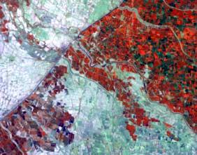
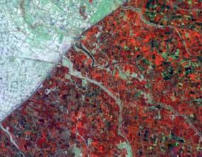
6 Landsat mosaic Indus Basin


7 Developments Chasma Right Bank

8 Cropping intensity of irrigated land (Cen sus-remote sen sing)/census* 100% kharif 1994 rabi ID command area 100% 200% (Sensus-remote sensing)/sensus * 100 % AZ-IIIb AZ-IVa AZ-X AZ-IIIa AZ-II AZ-I Aggregated unit Kharif Rabi

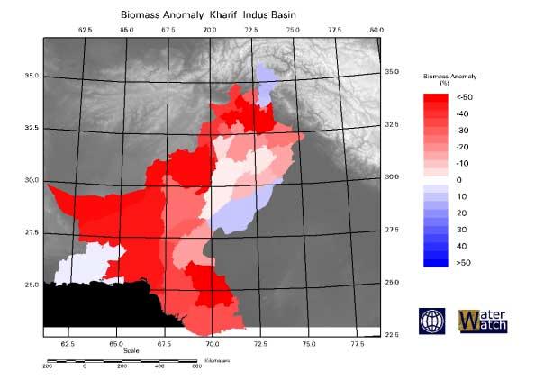
9 Water consumption Indus Basin
10 Intercomparison with hydrological models Source: Ph.D. thesis dr. Sarwar Qureshi

11 ASTER, ETact, August 4, 2001

12 Soil moisture Indus Basin Source: IWMI, Lahore

13 ASTER, Soil moisture, August 4, 2001

14 Water balance, Rechna Doab - Pakistan

15 Net groundwater use, Pakistan I ngw (mm yr -1 ) source: dr. Mobin-ud-Din Ahmad
16 Reliance of agriculture on groundwater
17 Wheat yield variability
18 Wheat yield variability

19 Impact of water on crop growth

20 Crop water productivity (kg/m3)
21 Waterlogging Chasma RB winter Waterlogging intensity (%) in Rabi polygon no rabi 2000 rabi 2001 rabi
22 Waterlogging Chasma RB summer Waterlogging intensity (%) in Kharif polygon no kharif 1999 kharif 2001 kharif

23 Soil salinity Egypt

24 Physical drought
25 Drought and vulnerability
26 Hydrological model - Sirsa
27 Simulation without remote sensing
28 Simulation with remote sensing
29 Nutshell Problems Indus Basin Inequity in canal water distribution Falling and rising groundwater tables Soil salinity build up Low crop water productivity Coping with droughts Good data is scarce Build a common databases
30 Remote sensing data streams 1. Baseline data I. Actual irrigated area (5 years) II. Crop occurrances (10 years) III. Digital Elevation Model IV. Traditional databases (soil map, canal command boundaries, water table etc.) 2. Process monitoring (weekly/monthly) I. Water consumption II. Crop growth III. Water logging IV. Soil salinity
31 Towards Indus Basin Environmental and Social Baseline Databases Remote sensing data provides key crop and water related data Satellite data is objective and freely accessible, distribution is easy Management targets should be prioritised Remote sensing data acquisition should meet water management objectives Scale issues should be decided upon (sample areas or entire Indus Basin?) Baseline and monitoring data need to be distinguished Remote sensing data can be coupled to Indus Basin model

32 Canal command area map
33 Soil map of Pakistan Soil Map of Indus Basin N W E S Types of Soils Calcareous Clayey Soils Calcareous Loamy Soils Calcareous Sandy Soils Calcareous Sandy Soils and Dun es Clayey Soils Gravely Land and Rock Land Gullied Land and Bad Land Loamy Soils Mountainous Land with Patchy Soil Cover Non Calcareous Clayey Soils Noncalcareous Loamy Soil Not Defined Open Water and Marsh Rough Broken Land Rough Mountainous Land Salt-affected Soils Sand Dunes and Sandy Soils Sandy Soils and Sand Dunes Seasonally Flo oded So ils and Rivers Silty and Clayey Soils Soils with very high Gypsiferous Salinity Tidal Flat and Sea Creeks Kilometers
34 ASTER images
35 Net groundwater use P + I cw + NGW =ET a + S P =Precipitation I cw = Canal water NGW = Net groundwater use ET = Evapotranspiration S = Storage change I tw = Tubewell irrigation q (h m =0) = Recharge q (h m =0) = Capillary rise NGW = Tubewell irrigation + Capillary rise - Recharge
36 Water productivity and scale 6.0 Wheat (rabi ) Per unit consumed Per unit diverted Water productivity (kg/m3) Cumulative Irrigated Area (million ha)
Managing Scarce Water Resources in Asia: Nature of the Problem and can Remote Sensing help?
 Managing Scarce Water Resources in Asia: Nature of the Problem and can Remote Sensing help? Wim Bastiaanssen (WaterWatch) & Rao Harshadeep (World Bank) Where do people settle? Population distribution in
1.6 Influence of Human Activities and Land use Changes on Hydrologic Cycle
 1.6 Influence of Human Activities and Land use Changes on Hydrologic Cycle Watersheds are subjected to many types of changes, major or minor, for various reasons. Some of these are natural changes and
INDUS BASIN IRRIGATION SYSTEM: WATER BUDGET AND ASSOCIATED PROBLEMS
 INDUS BASIN IRRIGATION SYSTEM: WATER BUDGET AND ASSOCIATED PROBLEMS Dr. Shahid Ahmad and Rashida Majeed* Abstract Around 74% of mean annual river flows (140 MAF) are diverted to the canal system and the
MANAGEMENT OF SMALL-SCALE WATER LOGGING THROUGH SURFACE DRAIN MAINTENANCE
 Sarhad J. Agric. Vol. 23, No. 2, 2007 MANAGEMENT OF SMALL-SCALE WATER LOGGING THROUGH SURFACE DRAIN MAINTENANCE Tahir Sarwar, S. M. Bilal, Naveedullah, M. Jamal Khan and Javaid Tariq ABSTRACT The present
Prospectives and Limits of Groundwater Use in Pakistan
 Prospectives and Limits of Groundwater Use in Pakistan International Waterlogging and Salinity Research Institute, Lahore, Pakistan Abstract Groundwater use in Pakistan has increased due to increased demand
Modeling the Managed Aquifer Recharge for Groundwater Salinity Management in the Sokh River Basin
 Modeling the Managed Aquifer Recharge for Groundwater Salinity Management in the Sokh River Basin A. Karimov, 1 I. Gracheva, 2 F. Miryusupov 2 1 International Water Management Institute (IWMI) Central
Issue paper: Aquifer Water Balance
 Issue paper: Aquifer Water Balance 1. Introduction And Background 1.1. Purpose and Scope The population in Kitsap County has grown rapidly in recent years and is expected to increase substantially in the
Pakistan Development Forum. Presentation by
 Pakistan Development Forum Presentation by M. Ali Shah, Country Director, ADB Pakistan Resident Mission Islamabad 18 March 2004 Part 1 - An Overview of Pakistan Part 2 - The Water Perspective Part 3 -
Remote sensing monitoring in the Awati pilot area The possibilities of operational remote sensing to support land and water management planning
 The possibilities of operational remote sensing to support land and water management planning Location Tarim Basin, northwestern China Contractor World Bank Period 2001-2002 Scope of the project The Tarim
Advancing hydrological research applied to watershed management: achievements and prospects in South and East Mediterranean Countries
 Advancing hydrological research applied to watershed management: achievements and prospects in South and East Mediterranean Countries Jean Albergel Hydrologist at IRD Kenya EFIMED, Marrakech 29 and 3 April
Utilization of water resources and its effects on the hydrological environment of the Tarim River basin in Xinjiang, China
 Water Resources Systems Water Availability and Global Change (Proceedings of symposium HS02n held during IUGG2003 al Sapporo. July 2003). IAHS Publ. no. 280. 2003. 23 Utilization of water resources and
Application of SWAT Model in land-use. change in the Nile River Basin: A Review
 Application of SWAT Model in land-use change in the Nile River Basin: A Review By: Marwa Ali, Okke Batelaan and Willy Bauwens 15-6-2011 Application of SWAT Model in land-use 1 change in the Nile River
Irrigation Improvement Options part 1- on field irrigation
 Training Course Conceptual irrigation design in the context of IRBM Arba Minch University, Arba Minch 26 30 March, 2012 Irrigation Improvement Options part 1- on field irrigation March 2012, Henk Ritzema
Climate change science, knowledge and impacts on water resources in South Asia
 Climate change science, knowledge and impacts on water resources in South Asia DIAGNOSTIC PAPER 1 GUILLAUME LACOMBE, PENNAN CHINNASAMY Regional Conference on Risks and Solutions: Adaptation Frameworks
Hydrology and Water Management. Dr. Mujahid Khan, UET Peshawar
 Hydrology and Water Management Dr. Mujahid Khan, UET Peshawar Course Outline Hydrologic Cycle and its Processes Water Balance Approach Estimation and Analysis of Precipitation Data Infiltration and Runoff
PAKISTAN BALOCHISTAN SMALL SCALE IRRIGATION PROJECT (SSIP) PROJECT INFORMATION DOCUMENT (PID) CONCEPT STAGE Report No.: AB1661 Project Name
 PROJECT INFORMATION DOCUMENT (PID) CONCEPT STAGE Report No.: AB1661 Project Name") PAKISTAN BALOCHISTAN SMALL SCALE IRRIGATION PROJECT (SSIP) PROJECT INFORMATION DOCUMENT (PID) CONCEPT STAGE Report No.: AB1661 Project Name Balochistan Small Scale Irrigation Project Region SOUTH ASIA
PAKISTAN BALOCHISTAN SMALL SCALE IRRIGATION PROJECT (SSIP) PROJECT INFORMATION DOCUMENT (PID) CONCEPT STAGE Report No.: AB1661 Project Name Balochistan Small Scale Irrigation Project Region SOUTH ASIA
IRAN GEOGRAPHY AND POPULATION
 IRAN GEOGRAPHY AND POPULATION The Islamic Republic of Iran covers a total area of about 1.65 million km² and is bordered by Azerbaijan, Armenia, the Caspian Sea and Turkmenistan to the north, Afghanistan
Estimating Agricultural Water Consumption impacts on water level fluctuations of Urmia Lake, Iran
 Estimating Agricultural Water Consumption impacts on water level fluctuations of Urmia Lake, Iran Leila Eamen 1 and A. B. Dariane* 2 1. MSc. Student, Dept. of Civil Eng., K.N. Toosi Univ. of Tech. 2. Associate
Water management innovation for meeting Climate change effects and European Water Framework Directive targets: Pilot study Lankheet
 Water management innovation for meeting Climate change effects and European Water Framework Directive targets: Pilot study Lankheet E.P. Querner, P.J.T. van Bakel and H.M. Mulder Alterra, Centre for Water
Groundwater Balance Study in the High Barind, Bangladesh. A.H.M.Selim Reza 1, Quamrul Hasan Mazumder 1 and Mushfique Ahmed 1
 Rajshahi University J. of Sci. 39, 11-26 (2011) ISSN 1681-0708 Groundwater Balance Study in the High Barind, Bangladesh A.H.M.Selim Reza 1, Quamrul Hasan Mazumder 1 and Mushfique Ahmed 1 1 Department of
Rock Creek Floodplain Analysis
 Rock Creek Floodplain Analysis www.co.washington.or.us By Jon Franczyk 1996 Flood, www.co.washington.or.us 1996 Flood, www.co.washington.or.us Project Outline Project Goals Introduction Background Study
Note that the Server provides ArcGIS9 applications with Spatial Analyst and 3D Analyst extensions and ArcHydro tools.
 Remote Software This document briefly presents the hydrological and hydraulic modeling software available on the University of Nice Server with Remote Desktop Connection. Note that the Server provides
Hydrologic Modeling with the Distributed-Hydrology- Soils- Vegetation Model (DHSVM)
") Hydrologic Modeling with the Distributed-Hydrology- Soils- Vegetation Model (DHSVM) DHSVM was developed by researchers at the University of Washington and the Pacific Northwest National Lab 200 Simulated
Hydrologic Modeling with the Distributed-Hydrology- Soils- Vegetation Model (DHSVM) DHSVM was developed by researchers at the University of Washington and the Pacific Northwest National Lab 200 Simulated
Water Resources on PEI: an overview and brief discussion of challenges
 Water Resources on PEI: an overview and brief discussion of challenges Components: Components and links Atmospheric water Surface water (including glacial water) Groundwater Links: Precipitation (atm(
Option 11. Divert Water from Miocene and Hendricks Canal to Supply the Ridge
 Integrated Water Resources Plan Option 11 Divert Water from Miocene and Hendricks Canal to Supply the Ridge This option would use water from the Miocene Canal and/or Hendricks Canal for municipal supplies
Lecture 9A: Drainage Basins
 GEOG415 Lecture 9A: Drainage Basins 9-1 Drainage basin (watershed, catchment) -Drains surfacewater to a common outlet Drainage divide - how is it defined? Scale effects? - Represents a hydrologic cycle
WATERSHED. Maitland Valley. Report Card 201
 Maitland Valley WATERSHED Report Card 201 The Maitland Valley Conservation Authority has prepared this report card as a summary on the state of our forests, wetlands, surface water, and ground water resources.
BASIN-WIDE REMOTE SENSING OF ACTUAL EVAPOTRANSPIRATION AND ITS INFLUENCE ON REGIONAL WATER RESOURCES PLANNING
 BASIN-WIDE REMOTE SENSING OF ACTUAL EVAPOTRANSPIRATION AND ITS INFLUENCE ON REGIONAL WATER RESOURCES PLANNING Daniel J. Howes 1 Charles M. Burt 2 Kyle Feist 3 ABSTRACT The Irrigation Training & Research
15. Soil Salinity SUMMARY THE ISSUE
 15. Soil Salinity AUTHORS: B.H. Wiebe, R.G. Eilers, W.D. Eilers and J.A. Brierley INDICATOR NAME: Risk of Soil Salinization STATUS: Provincial coverage (AB, SK, MB), 1981 to 2001 SUMMARY At very low levels,
Application of Mathematical Modelling to Development Issues: An Illustrative Model on Agricultural Systems 1
 Application of Mathematical Modelling to Development Issues: An Illustrative Model on Agricultural Systems 1 Shahid Ahmad 2 Abstract Agricultural systems are diverse in nature depending upon the agro-ecology,
Water Management in the Indus Basin in Pakistan: Challenges and Opportunities
 Water Management in the Indus Basin in Pakistan: Challenges and Opportunities Author(s): Asad Sarwar Qureshi Source:, 31(3):252-260. Published By: International Mountain Society https://doi.org/10.1659/mrd-journal-d-11-00019.1
Watershed: an area or ridge of land that separates waters flowing to different rivers, basins, or seas. It is the interdependent web of living
 Watershed: an area or ridge of land that separates waters flowing to different rivers, basins, or seas. It is the interdependent web of living organisms that inhabit a geographic area and depend on it
Integrated Regional. South Tahoe Public Utility District. Water Management Plan. July 2014 K/J Prepared By Kennedy/Jenks Consultants
 Tahoe-Sierra Integrated Regional Water Management Plan July 2014 K/J 1270036 Photo courtesy of Matthew Grimm South Tahoe Public Utility District Prepared By Kennedy/Jenks Consultants 10850 Gold Center
Applying the METRIC Evapotranspiration Model in Idaho
 Applying the METRIC Evapotranspiration Model in Idaho The First Step, Not the Last Word Anthony Morse and William J. Kramber Idaho Department of Water Resources Boise, Idaho THE FIRST STEP Prototype Applications
 Good Morning! Bruce Gilman Department of Environmental Conservation and Horticulture Finger Lakes Community College 3325 Marvin Sands Drive Canandaigua, New York 14424 585-785- 1255 gilmanba@flcc.edu Northern
Joint Research Centre (JRC)
") Joint Research Centre (JRC) Marco Pastori and Faycal Bouraoui IES - Institute for Environment and Sustainability Ispra - Italy http://ies.jrc.ec.europa.eu/ http://www.jrc.ec.europa.eu/ CONTENT Introduction
Joint Research Centre (JRC) Marco Pastori and Faycal Bouraoui IES - Institute for Environment and Sustainability Ispra - Italy http://ies.jrc.ec.europa.eu/ http://www.jrc.ec.europa.eu/ CONTENT Introduction
WATER FROM THE CLOUDS
 WATER FROM THE CLOUDS 814 mm per year on land or 110 000 km 3 56% is evapotranspirated by forests and natural landscapes 5% is evapotranspirated by rainfed agriculture 39% available for human uses (irrigation,
Artificial Groundwater Recharge through Recharge Tube Wells: A Case Study
 Artificial Groundwater Recharge through Recharge Tube Wells: A Case Study M J Kaledhonkar, Non-member O P Singh, Non-member S K Ambast, Non-member N K Tyagi, Non-member K C Tyagi, Non-member Two-recharge
Introduction. Welcome to the Belgium Study Abroad Program. Courses:
 Introduction Welcome to the Belgium Study Abroad Program Courses: AGSM 335: Soil and Water Management BAEN 460: Principals of Environmental Hydrology BAEN 460 / AGSM 335 Combined lecture and HW sessions
Outline. Remote Sensing, GIS & DEM for Hydrological Modeling (AV-SWAT) Role of Remote Sensing in Watershed & Water Quality Models
 Role of Remote Sensing in Watershed & Water Quality Models") Remote Sensing, GIS & DEM for Hydrological Modeling (AV-SWAT) Prof. D. Nagesh Kumar Dept. of Civil Engg. Indian Institute of Science Bangalore 6 12 1 Outline Geographic Information System (GIS) Digital
Remote Sensing, GIS & DEM for Hydrological Modeling (AV-SWAT) Prof. D. Nagesh Kumar Dept. of Civil Engg. Indian Institute of Science Bangalore 6 12 1 Outline Geographic Information System (GIS) Digital
Water, Salinity and Irrigation in Australia s Murray-Darling Basin & Hetao Irrigation District
 Water, Salinity and Irrigation in Australia s Murray-Darling Basin & Hetao Irrigation District Ian White Australian National University Ian White FTSE Research Major research area is water resources with
Rationally Utilizing Water Resources to Control Soil Salinity in Irrigation Districts
 This paper was peer-reviewed for scientific content. Pages 1134-1138. In: D.E. Stott, R.H. Mohtar and G.C. Steinhardt (eds). 2001. Sustaining the Global Farm. Selected papers from the 10th International
Application of a Basin Scale Hydrological Model for Characterizing flow and Drought Trend
 Application of a Basin Scale Hydrological Model for Characterizing flow and Drought Trend 20 July 2012 International SWAT conference, Delhi INDIA TIPAPORN HOMDEE 1 Ph.D candidate Prof. KOBKIAT PONGPUT
Very slight to negligible limitations no special land management practices required.
 Land Capability Classes Land and Soil Capability Class 1 Class 1 Definition Very slight to negligible limitations no special land management practices required. On-site impact of land management practices
Climate change and groundwater resources in Lao PDR
 Journal of Groundwater Science and Engineering Vol.5 Vol.4 No.1 No.2 Mar. Jun. 2016 2017 Climate change and groundwater resources in Lao PDR Khongsab Somphone 1*, OunakoneKone Xayviliya 1 1 Division of
Saturated Buffer. Subsurface Drainage PURPOSE N REDUCTION LOCATION COST BARRIERS
 Saturated Buffer To intercept tile drainage prior to discharging to surface waters and redistribute the water laterally in the soil profile of the streamside buffer. Subsurface drainage, also known as
Potential effects evaluation of dewatering an underground mine on surface water and groundwater located in a rural area
 Potential effects evaluation of dewatering an underground mine on surface water and groundwater located in a rural area ITRODUCTIO Michel Mailloux* Eng. M.Sc, Vincent Boisvert, M.Sc, Denis Millette, Eng.,
Effects of Paddy Field conversion to urban use on watershed hydrology in Southern China
 Effects of Paddy Field conversion to urban use on watershed hydrology in Southern China Di Fang, Mengsheng Qin, Hong Qian, Lei Sun, Lu Hao Nanjing University of Information Science and Technology Background
Information Request 37
 Information Request 37 Information Request 37 37-1 Response to Information Request 37 Response to Information Requests 37a Response to Information Requests 37b 37-3 37-5 Federal Review Panel Information
ANNEXE 5B Sahiwal Hydrology and Modeling for Climate Risk and Vulnerability Assessment (CRVA) Pre-Feasibility Study for Sialkot and Sahiwal Cities
 Pre-Feasibility Study for Sialkot and Sahiwal Cities") REG-8556 ANNEXE 5B Sahiwal Hydrology and Modeling for Climate Risk and Vulnerability Assessment (CRVA) Pre-Feasibility Study for Sialkot and Sahiwal Cities REG-8556 ANNEXE 5B Page i TABLE OF CONTENTS EXECUTIVE
REG-8556 ANNEXE 5B Sahiwal Hydrology and Modeling for Climate Risk and Vulnerability Assessment (CRVA) Pre-Feasibility Study for Sialkot and Sahiwal Cities REG-8556 ANNEXE 5B Page i TABLE OF CONTENTS EXECUTIVE
Water Footprints of Milk Production
 Water Footprints of Milk Production A Case Study in the Moga district of Punjab, India Upali Amarasinghe, Vladimir Smakhtin, Bharat Sharma and Nishadi Eriyagama of International Water Management Institute
Sterling and Gilcrest/LaSalle High Groundwater Analysis
 FINAL REPORT Prepared for The State of Colorado, Department of Natural Resources Sterling and Gilcrest/LaSalle High Groundwater Analysis July 2015 Sterling and Gilcrest/LaSalle High Groundwater Analysis
Mission. Selected Accomplishments from Walnut Gulch. Facilities. To develop knowledge and technology to conserve water and soil in semi-arid lands
 USDA-ARS Southwest Watershed Research Center Mission Sound Science for Watershed Decisions To develop knowledge and technology to conserve water and soil in semi-arid lands ARS Watershed Locations Selected
The South Australian River Murray is a highly regulated system comprised of a series of
 1 2 The South Australian River Murray is a highly regulated system comprised of a series of lake-like pools with largely stable water levels. These relatively deep, slow moving pools of water with stable
Application of Space Technology to Water Resources Management & Dragon Project. Li Jiren. Digital Basin Research Centre Institute of Digital china
 Application of Space Technology to Water Resources Management & Dragon Project Li Jiren Digital Basin Research Centre Institute of Digital china 1. Application of space technology to water resources management
To provide timely, accurate, and useful statistics in service to U.S. agriculture
 NASS MISSION: To provide timely, accurate, and useful statistics in service to U.S. agriculture What does NASS do? Administer USDA s Statistical Estimating Program Conduct the 5-year Census of Agriculture
Colorado River Basin Water Supply and Demand Study. WRRC 2013 Conference University of Arizona Tucson, AZ March 5, 2013
 Colorado River Basin Water Supply and Demand Study WRRC 2013 Conference University of Arizona Tucson, AZ March 5, 2013 Colorado River Basin Water Supply and Demand Study Study Objective Assess future water
Northern Arizona Hydrogeology
 Northern Arizona Hydrogeology Some basics Coconino Plateau Hydrogeology Flagstaff and Coconino Plateau Water Resources Well development, City of Flagstaff Effluent discharge to the Rio de Flag from Wildcat
Southern Africa perspective - Identification and Mapping National Freshwater Ecosystems Priority Areas in South Africa
 Southern Africa perspective - Identification and Mapping National Freshwater Ecosystems Priority Areas in South Africa SA National Wetland Inventory By N Mbona Outline National Wetland Inventory SA Wetland
ESTIMATION OF NET GROUNDWATER USE IN IRRIGATED RIVER BASINS USING GEO-INFORMATION TECHNIQUES A CASE STUDY IN RECHNA DOAB, PAKISTAN
 ESTIMATION OF NET GROUNDWATER USE IN IRRIGATED RIVER BASINS USING GEO-INFORMATION TECHNIQUES A CASE STUDY IN RECHNA DOAB, PAKISTAN Promotor: Co-promotor: Prof. dr. ir. R.A. Feddes Professor of Soil Physics,
Dynamic Statewide Water Budget for Water Planning in New Mexico
 Dynamic Statewide Water Budget for Water Planning in New Mexico Sep 20 2016 Ongoing Drought in New Mexico and the West Jan 20 2015 April 8 2014 July 9 2013 Elephant Butte Storage (AF) Surface supplies
Issues include coverage gaps, delays, measurement continuity and consistency, data format and QC, political restrictions
 Satellite-based Estimates of Groundwater Depletion, Ph.D. Chief, Hydrological Sciences Laboratory NASA Goddard Space Flight Center Greenbelt, MD Groundwater Monitoring Inadequacy of Surface Observations
Satellite surveillance of evaporative depletion across the Indus Basin
 WATER RESOURCES RESEARCH, VOL. 38, NO. 12, 1273, doi:10.1029/2001wr000386, 2002 Satellite surveillance of evaporative depletion across the Indus Basin Wim G. M. Bastiaanssen, 1,2 Mobin-ud-Din Ahmad, 2,3
Physiographic zones. and water quality
 Southland Physiographic zones Central Plains Technical information Physiographic zones are part of the Water and Land 2020 & Beyond project that aims to maintain and improve water quality in the Southland
Water Resources Development and Utilization in the Zayandeh Rud basin, Iran
 Proceedings of The Fourth International Iran & Russia Conference 1297 Water Resources Development and Utilization in the Zayandeh Rud basin, Iran Hamid R. Salemi 1, Nader Heydari 2, Hammond M. Rust 3 1-Isfahan
Estimating the Seasonal High Water Table: A Mix of Art & Science
 Estimating the Seasonal High Water Table: A Mix of Art & Science PONDS WORKSHOP - SJRWMD Devo Seereeram, Ph.D., P.E. This paper was originally written over 4 years ago & generated a lot of interest. The
AMERICAN INSTITUTE OF HYDROLOGY EDUCATIONAL CRITERIA
 AMERICAN INSTITUTE OF HYDROLOGY EDUCATIONAL CRITERIA AIH FORM011A Rev. 11/21/17 BASIC REQUIREMENTS Completion of a full course of study leading to a bachelor's or higher degree at an accredited college
Appendix 12. Pollutant Load Estimates and Reductions
 Appendix 12. Pollutant Load Estimates and Reductions A pollutant loading is a quantifiable amount of pollution that is being delivered to a water body. Pollutant load reductions can be calculated based
Salt Dynamics in prairie wetlands under changing climate
 Salt Dynamics in prairie wetlands under changing climate Uri Nachshon Andrew Ireson Garth van der Kamp Howard Wheater Ryan Davies GIWS, University of Saskatchewan GIWS, University of Saskatchewan Environment
Chapter 9: Adoption and impact of supplemental irrigation in wheat-based systems in Syria
 Chapter 9: Adoption and impact of supplemental irrigation in wheat-based systems in Syria 131 132 Chapter 9: Adoption and impact of supplemental irrigation in wheat-based systems in Syria A. Bader, N.
District Management System Program IMPLEMENTATION OF A DISTRICT MANAGEMENT SYSTEM IN THE LOWER RIO GRANDE VALLEY OF TEXAS (1)
") Page 1 of 11 IMPLEMENTATION OF A DISTRICT MANAGEMENT SYSTEM IN THE LOWER RIO GRANDE VALLEY OF TEXAS (1) Guy Fipps and Craig Pope(2) ABSTRACT The Lower Rio Grande Valley of Texas is undergoing rapid population
Page 1 of 11 IMPLEMENTATION OF A DISTRICT MANAGEMENT SYSTEM IN THE LOWER RIO GRANDE VALLEY OF TEXAS (1) Guy Fipps and Craig Pope(2) ABSTRACT The Lower Rio Grande Valley of Texas is undergoing rapid population
Long Island: Water Resources. Water Sayings. Water Issues. Water Quality Issues specific to LI Coastal Areas. Agriculture and Water Regulation
 Water Sayings Long Island: Water Resources Copyright 2011 AFG 1 All living things need water to survive after air. Water, water everywhere but not a drop to drink. The quality of water is just as important
Recommendations for effective water use in agriculture under changing climate perspectives from Poland
 Recommendations for effective water use in agriculture under changing climate perspectives from Poland Leszek Labedzki Institute for Land Reclamation and Grassland Farming Regional Research Centre in Bydgoszcz,
CITY OF MOUNTAIN VIEW
 CITY OF MOUNTAIN VIEW Incorporate Climate Change Adaptation in Municipal Scale, Urban Watershed Planning at the City of Mountain View Raymond Wong, PhD, PE, LEED AP Lisa Au, PE Floodplain Management Association
What Are Environmental (Instream) Flows?
 Flows?") 1 What Are Environmental (Instream) Flows? Sustainable water management requires that both human needs and the needs of aquatic and riparian ecosystems be fulfilled. Dams and diversion of water for municipal
1 What Are Environmental (Instream) Flows? Sustainable water management requires that both human needs and the needs of aquatic and riparian ecosystems be fulfilled. Dams and diversion of water for municipal
ISPRS Archives XXXVIII-8/W3 Workshop Proceedings: Impact of Climate Change on Agriculture
 IMPACT ANALYSIS OF CLIMATE CHANGE ON DIFFERENT CROPS IN GUJARAT, INDIA Vyas Pandey, H.R. Patel and B.I. Karande Department of Agricultural Meteorology, Anand Agricultural University, Anand-388 110, India
Understanding Groundwater. December 9, 2015
 Understanding Groundwater December 9, 2015 Speakers Gabriele Ludwig, Almond Board (Moderator) Graham Fogg, University of California, Davis Gabriele Ludwig, Almond Board Graham Fogg, University of California,
Flood Modelling and Water Harvesting Plan for Paravanar Basin
 International Journal of ChemTech Research CODEN (USA): IJCRGG, ISSN: 0974-4290, ISSN(Online):2455-9555 Vol.10 No.14, pp 01-08, 2017 Flood Modelling and Water Harvesting Plan for Paravanar Basin Dhinesh
DUGWELL AS AN OPTION OF SKIMMING WELL
 DUGWELL AS AN OPTION OF SKIMMING WELL Paper prepared for presentation in the year-end seminar of the project entitled "Root Zone Salinity Management Using Skimming Wells with Pressurised Irrigation Systems"
A WATER-SECURE WORLD
 WWW.IWMI.ORG A WATER-SECURE WORLD IWMI A WATER-SECURE WORLD COVER PHOTO JOE RONZIO / IWMI 2 THE INTERNATIONAL WATER MANAGEMENT INSTITUTE (IWMI) OPERATES AT THE INTERFACE OF RESEARCH AND DEVELOPMENT TO
Climate Change Impact to the Water Resources of Eastern Caucasus (Kura Basin) Rivers and Ways of Its Mitigation
 Rivers and Ways of Its Mitigation") Journal of Hydraulic Engineering 1 (2016) 32-37 doi: 10.17265/2332-8215/2016.01.004 D DAVID PUBLISHING Climate Change Impact to the Water Resources of Eastern Caucasus (Kura Basin) Rivers and Ways of Its
Journal of Hydraulic Engineering 1 (2016) 32-37 doi: 10.17265/2332-8215/2016.01.004 D DAVID PUBLISHING Climate Change Impact to the Water Resources of Eastern Caucasus (Kura Basin) Rivers and Ways of Its
GEO-DRI Drought Monitoring Workshop, May 10-11, 2010, Winnipeg, Manitoba. Drought in Southeast Asia
 GEO-DRI Drought Monitoring Workshop, May 10-11, 2010, Winnipeg, Manitoba Drought in Southeast Asia Climate change, drought, agriculture and economics was caused by an early end to the monsoon season coupled
Agriculture Sector Analysis
 Public Disclosure Authorized Public Disclosure Authorized Public Disclosure Authorized Public Disclosure Authorized Dissemination Note Series Romania: Toward a Low Carbon and Climate Resilient Economy
Shortage on the Colorado River: Analysis of Impacts to Water Users in Central Arizona. Ken Seasholes
 Shortage on the Colorado River: Analysis of Impacts to Water Users in Central Arizona Ken Seasholes Manager, Resource Planning & Analysis AWRA Annual Conference, Denver November 19, 2015 Colorado River
Groundwater modelling to assess the effect of interceptor drainage and lining
 Irrigation and Drainage Systems (2006) 20: 23 40 C Springer 2006 Groundwater modelling to assess the effect of interceptor drainage and lining Example of model application in the Fordwah Eastern Sadiqia
Water Security for Sustainable Development: The challenge of Scarcity in the Middle East & North Africa
 Water Security for Sustainable Development: The challenge of Scarcity in the Middle East & North Africa Shawki Barghouti Director General International Center for Biosaline Agriculture 1 water scarcity
AP Environmental Science
 AP Environmental Science Types of aquatic life zones MARINE Estuaries coral reefs mangrove swamps neritic zone pelagic zone FRESHWATER lakes and ponds streams and rivers wetlands Distribution of aquatic
Groundwater resources in the Indo Gangetic Basin
 Groundwater resources in the Indo Gangetic Basin Resilience to climate change and abstraction Executive Summary Groundwater within the Indo Gangetic Basin (IGB) alluvial aquifer system forms one of the
*to whom all correspondence should be addressed:
 Global NEST Journal, Vol 18, No 1, pp 56-66, 2016 Copyright 2016 Global NEST Printed in Greece. All rights reserved EVALUATION OF THE ENVIRONMENTAL IMPACT OF AN IRRIGATION NETWORK IN A RAMSAR AREA OF THE
Introduction to hydrology and the water balance
 Introduction to hydrology and the water balance The science of hydrology The science that describes and predicts the occurrence, circulation and distribution of the earth s water. There are two principal
Water Education Foundation Briefing Water Year 2016: San Joaquin Valley Groundwater Conditions
 Groundwater in Fractured Rock Aquifers Well Location, Yield, and Sustainability Water Education Foundation Briefing Water Year 2016: San Joaquin Valley Groundwater Conditions John Kirk, PG, CEG, CHG Engineering
Interruptible Supply Study
 Interruptible Supply Study Prepared by AECOM USA Group, Inc. Kellogg Brown & Root Services, Inc. LBG-Guyton Associates Ekistics Corporation June 2009 AECOM Job No. 60072790 Interruptible Supply Study for
Southern Finland regional analysis
 Southern Finland regional analysis Background for the exercise Training example and data created originally for training of regional council of Southern Finland 2013 Aims at presenting a realitic, yet
Prediction for Natural Recharging In Langat Basin and Ukm Campus as Case Study
 Prediction for Natural Recharging In Langat Basin and Ukm Campus as Case Study 1 Mohaad Fawzi Al Ajlouni, 2 Rakmi Abd Rahman, 3 Abdul Ghani Rafek, 4 Mazlin Mokhtar, 5 Noor Ezlin Ahmad Basri 1, 5 Department
Texas Water Resources Institute
 Texas Water Resources Institute April 1975 Volume 1 No. 5 Opportunities for Artificial Recharge By Jim Valliant, Research Engineer, Texas Agricultural Experiment Station Put "dirty" water back underground--i'd
Geospatial analysis of Qadirabad-Baloki link canal in Pakistan
 American Journal of Science and Technology 2014; 1(5): 334-339 Published online October 30, 2014 (http://www.aascit.org/journal/ajst) ISSN: 2375-3846 Geospatial analysis of Qadirabad-Baloki link canal
A Final Ecosystem Goods and Services Classification System (FEGS-CS)
") United States Environmental Protection Agency Office of Research and Development A Final Ecosystem Goods and Services Classification System (FEGS-CS) Dixon H. Landers and Amanda M. Nahlik US EPA OFFICE
United States Environmental Protection Agency Office of Research and Development A Final Ecosystem Goods and Services Classification System (FEGS-CS) Dixon H. Landers and Amanda M. Nahlik US EPA OFFICE
Conjunctive Use and Management of Surface and Groundwater Resources as Part of Integrated River Basin Management
 Conjunctive Use and Management of Surface and Groundwater Resources as Part of Integrated River Basin Management Sudhakar Pathak, Abhishek Saxena Faculty of Civil Engineering, Shri Ramswaroop Memorial
Drought Situations and Management in Vietnam
 Drought Situations and Management in Vietnam Background: In Vietnam, drought is one of the most frequent natural disasters, only after flood and storm, and has been becoming more severe due to the impact