Estimation of Actual Evapotranspiration at Regional Annual scale using SWAT
|
|
|
- Katrina Maxwell
- 6 years ago
- Views:
Transcription

1 Estimation of Actual Evapotranspiration at Regional Annual scale using SWAT Azizallah Izady Ph.D student of Water Resources Engineering Department of Water Engineering, Faculty of Agriculture, Ferdowsi University of Mashhad, Mashhad, Iran
2 Overview Introduction Material and Methods Study Area Data Model Structure Results and Discussion Conclusion 2
3 Introduction Much research and many studies require a knowledge of ET. The main methods (e.g. lysimeter, Bowen ratio, ) have been conventionally used to measure ET at field or landscape scales; but regional ET cannot be measured directly. 3
4 Introduction Estimating ET at regional scale o Physical and empirical remote sensing-based models in combination with satellite data Need to precise validation of estimated ET o Using a hydrological models Fundamental elements of hydrological processes, such as precipitation, runoff, can be measured directly and imported to the model 4
5 Introduction Soil and Water Assessment Tool (SWAT) o SWAT-based ET could be used as the standard for accuracy assessment of remote sensing-based models (Gao and Long, 2008). o Multi-criteria calibration is required to improve model reliability. Calibration using crop yield and streamflow gives more confidence on the partitioning of water between soil storage, actual evapotranspiration, aquifer recharge. 5

6 Introduction The main objective of this study o Estimate actual ET (AET) using multi-criteria calibrated SWAT model in the Neishaboor watershed, Iran. 6
 = 89 CMS. Minimum =1050 m (Hosein Abad Jangal) 7")
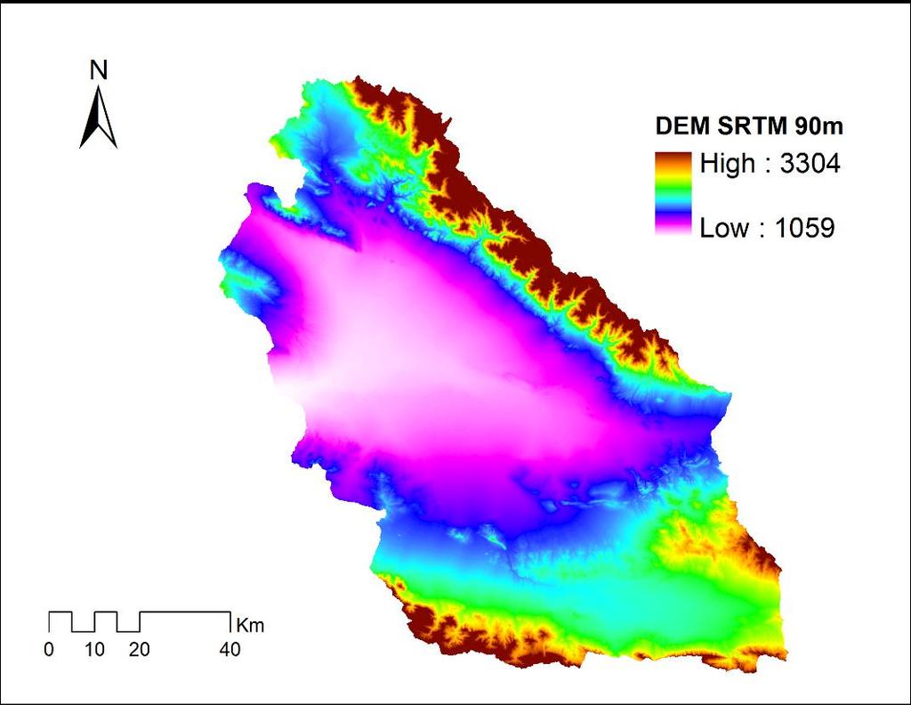
7 Study Area: Neishaboor watershed Mean annual precipitation 265 mm Mean annual temperatures 13 C Total area: Daily discharge at 9158 km outlet station km 2 mountain Average = km 2 plain CMS Elevation Minimum = zero Maximum= 3300 m maximum (Binalood mountain) = 89 CMS. Minimum =1050 m (Hosein Abad Jangal) 7


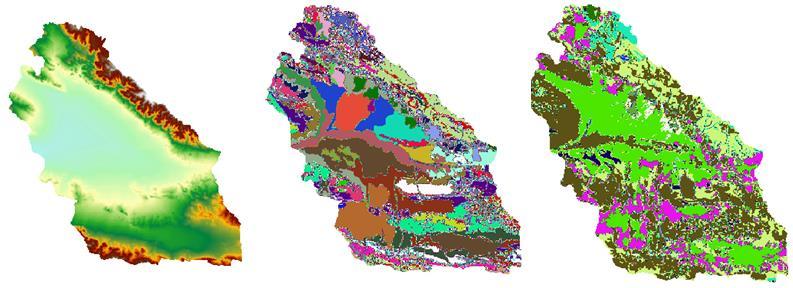


8 INPUT DATA DEM Soil Landuse SWAT MODEL Climate Crop Management Calibration 8
9 9
 was selected as the base elevation model.")
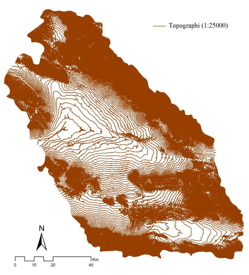
10 These were cross checked against each other (benchmark points), and for conflicting points a field measurement with deferential GPS technique was performed. SRTM DEM (grid cell: 90 90) was selected as the base elevation model. 10

11 Scale: 1: types of soils Official reports: Soil texture, rock fragment content, soil saturated hydraulic conductivity and organic carbon content RetC software (van Genuchten et al., 1991) Other required parameters 11
.")
12 Scale: 1: main classes Neishaboor watershed is predominantly agricultural (47% of watershed). Irrigated wheat and barley (70% of the 47%) Sugar beet, cotton, and alfalfa (30% of the 47%) 12
13 23 rain station 4 temperature station 3 solar radiation station Relative humidity and wind speed Weather generator 13
14 Neishaboor watershed is an agriculture-based watershed. The processes affecting the water balance in an agricultural watershed are highly influenced by crop management. Irrigated and rainfed wheat crops were considered. 14
15 Collecting crop management data Official reports Interview with large owner farmer Local experts 21 counties separately! Irrigate wheat Year Operation type Date Descriptions 1 Tillage September 26 Moldboard Plow 1 Tillage September 27 Leveler 1 Planting October 4-1 Fertilizer October 5 Phosphate ( ), 150 kg/ha 1 Auto-Irrigation October 6-2 Fertilizer March 15 Urea, 50 kg/ha 2 Fertilizer April 9 Urea, 50 kg/ha 2 Fertilizer April 30 Urea, 50 kg/ha 2 Harvest & Killing July 13 - Rainfed wheat Year Operation type Date Descriptions 1 Tillage November 23 Moldboard Plow 1 Tillage November 24 Leveler 1 Planting December 6-1 Fertilizer December 7 Phosphate ( ), 50 kg/ha 1 Fertilizer December 7 Urea, 50 kg/ha 2 Harvest & Killing July 17-15

16 Hydrometric and Crop Yield Data (Calibration) 5 hydrometric station Crop yield data County level Irrigated wheat Rainfed wheat 16
17 Model Structure: The simulation period: ; o The first 3 years were used as warm-up period. Precipitation lapse rate:160 mm/km Temperature lapse rate: 6 ºC/km Five elevation bands Solar radiation o Angstrom-Prescott equation Calculating ETp o The Hargreaves method. Automatic irrigation o Difficult to know when and how much the farmers apply irrigation 17
18 Model Structure: Neishaboor watershed was subdivided into 248 subbasins. Delineate with smallest possible threshold area (0.008%) Remove all generated outlets Assign new outlets regard to: Mountain-plain boundary Horticultural and agricultural farms border (landuse map) County boundaries Hydrometric station location Subbasins area should be less than 1% of the watershed area 18
 SUFI-2 Validation 3-year (2008-2010)")
19 One HRU for each subbasin was considered because of facility in entering crop management data to each subbasin Calibration 7-year ( ) SUFI-2 Validation 3-year ( ) 19
20 Result & Discussion 20
21 Sensitivity analysis 21 global parameters of hydrology were sensitive to river discharge All crop parameters also were sensitive to crop yield 21
22 Due to high stream bed water losses in semiarid and arid streams, most of the infiltration is through stream bed. Runoff is controlled by the reach transmission loss (TRNSRCH) in these regions (Sorman and Abdulrazzak, 1993; Scanlon et al., 2002; de Vries and Simmers, 2002; Sophocleous, 2005; Scanlon et al., 2006; Wheater, 2010; Edmunds, 2010; Yin et al., 2011) 22
23 Hydrology calibration and uncertainty analysis The calibration process was initiated from the upstream gauges - Andarab, Bar, Eishabad and Kharvm - as well as Hoseinabad. SWAT could not predict the base flow except for Andarab station. Because, in these stations the base flow of the river is mainly comes from springs. The springs were imported in these subbasins as point sources. But, the P-factor value increased only in the Kharvm station. 23

24 Inappropriate results in the Bar and Eishabad hydrometric stations: Severe elevation variability of these subbasins. Unaccounted human activities affecting natural hydrology during the period of study. Snow parameters are not spatially defined. Shortcomings of the SCS method It cannot simulate runoff from melting snow and on frozen ground It does not consider the duration and intensity of precipitation Eishabas and Bar station was removed from calibration period. 24
25 After calibrating Andarab, Eishabad and Hoseinabad separately, entire watershed was calibrated by considering fixed hydrology parameters for these stations. Hydrometric station P-factor R-factor R2 NS RMSE (CMS) Andarab Kharvm Hoseinabad (watershed outlet) 0.42 (0.36) a 0.35 (0.41) 0.85 (0.79) 0.84 (0.79) (0.005) 0.45 (0.42) 0.37 (0.61) 0.87 (0.74) 0.77 (0.66) (0.036) 0.37 (0.42) 0.68 (0.63) 0.82 (0.71) 0.79 (0.71) (0.004) 25

26 Andarab Kharvm Hoseinabad 26
27 Crop yield calibration and uncertainty analysis Calibration of a large-scale distributed hydrologic model 9159 km2 - against streamflow alone may not provide sufficient confidence for all components of the surface water balance. Crop yield is considered as an additional target variable in the calibration process. 27
28 28
29 Crop yield calibration and uncertainty analysis: Crop R-factor RMSE (ton ha -1 ) Irrigated wheat Rainfed wheat 0.97 (0.57) a (0.012) 1.16 (1.21) (0.039) SWAT was able to predict crop yield satisfactorily for irrigated wheat. Collecting crop management information at farm scale precisely (21 counties) 29
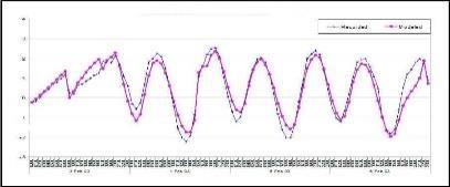
30 Plots of observed and simulated annual crop yield Irrigated wheat Rainfed wheat 30
31 Estimation and analysis of actual evapotranspiration The results showed that SWAT provided satisfactory predictions on hydrologic budget and crop yield. Hence, the multi-criteria calibrated model was then used to estimate and analyze the actual evapotranspiration at regional-annual scale. 31
32 mm 400 Actual ET P Time (year) Mean annual precipitation and actual ET 32


33 Estimation and analysis of actual evapotranspiration Whole watershed This ratio shows only the actual evapotranspiration from precipitation to precipitation ratio. 33
34 Estimation and analysis of actual evapotranspiration Groundwater is another source of water supply for irrigation purpose in the plain as well as precipitation. This source effects the actual ET considerably. Therefore, this ratio shows the total actual evapotranspiration (precipitation and irrigation) to precipitation ratio. Estimation of this ratio is not as simple as mountainous part of watershed due to uncertainties in the crop pattern data and their water requirements. 34
35 Conclusion 35
36 SWAT provided satisfactory predictions on hydrologic budget and crop yield. This study could be used to evaluate the estimated actual ET using RS. To enhance the performance of the model, crop management parameters of other major crops such as sugar-beat, cotton and alfalfa is necessary. 36


37 Thank you for your attention 37
Application of a Basin Scale Hydrological Model for Characterizing flow and Drought Trend
 Application of a Basin Scale Hydrological Model for Characterizing flow and Drought Trend 20 July 2012 International SWAT conference, Delhi INDIA TIPAPORN HOMDEE 1 Ph.D candidate Prof. KOBKIAT PONGPUT
USING ARCSWAT TO EVALUATE EFFECTS OF LAND USE CHANGE ON WATER QUALITY. Adam Gold Geog 591
 USING ARCSWAT TO EVALUATE EFFECTS OF LAND USE CHANGE ON WATER QUALITY Adam Gold Geog 591 Introduction The Soil and Water Assessment Tool (SWAT) is a hydrologic transport model with an objective to predict
The Fourth Assessment of the Intergovernmental
 Hydrologic Characterization of the Koshi Basin and the Impact of Climate Change Luna Bharati, Pabitra Gurung and Priyantha Jayakody Luna Bharati Pabitra Gurung Priyantha Jayakody Abstract: Assessment of
History of Model Development at Temple, Texas. J. R. Williams and J. G. Arnold
 History of Model Development at Temple, Texas J. R. Williams and J. G. Arnold INTRODUCTION Then Model development at Temple A long history (1937-present) Many scientists participating in: Data collection
Lecture 9A: Drainage Basins
 GEOG415 Lecture 9A: Drainage Basins 9-1 Drainage basin (watershed, catchment) -Drains surfacewater to a common outlet Drainage divide - how is it defined? Scale effects? - Represents a hydrologic cycle
Joint Research Centre (JRC)
") Joint Research Centre (JRC) Marco Pastori and Faycal Bouraoui IES - Institute for Environment and Sustainability Ispra - Italy http://ies.jrc.ec.europa.eu/ http://www.jrc.ec.europa.eu/ CONTENT Introduction
Joint Research Centre (JRC) Marco Pastori and Faycal Bouraoui IES - Institute for Environment and Sustainability Ispra - Italy http://ies.jrc.ec.europa.eu/ http://www.jrc.ec.europa.eu/ CONTENT Introduction
2
 1 2 3 4 5 6 The program is designed for surface water hydrology simulation. It includes components for representing precipitation, evaporation, and snowmelt; the atmospheric conditions over a watershed.
MODELING SEDIMENT AND PHOSPHORUS YIELDS USING THE HSPF MODEL IN THE DEEP HOLLOW WATERSHED, MISSISSIPPI
 MODELING SEDIMENT AND PHOSPHORUS YIELDS USING THE HSPF MODEL IN THE DEEP HOLLOW WATERSHED, MISSISSIPPI Jairo Diaz-Ramirez, James Martin, William McAnally, and Richard A. Rebich Outline Background Objectives
Farzad Emami Manfred Koch
 Modeling the Projected Impact of Climate Change on Boukan Dam Inflow and Water Availability in the Zarrine River Basin of Iran SWAT 2017 WARSAW Conference Farzad Emami Manfred Koch Institut für Geotechnik
Definitions 3/16/2010. GG22A: GEOSPHERE & HYDROSPHERE Hydrology
 GG22A: GEOSPHERE & HYDROSPHERE Hydrology Definitions Streamflow volume of water in a river passing a defined point over a specific time period = VxA discharge m 3 s -1 Runoff excess precipitation - precipitation
API SOIL & GROUNDWATER RESEARCH BULLETIN
 American API SOIL & GROUNDWATER RESEARCH BULLETIN A summary of research results from API s Soil and Groundwater Technical Task Force. No. 2 March 1997 Estimation of Infiltration and Recharge for Environmental
Hydrological Modeling of the Black Sea Catchment using SWAT
 South Korea, August, 2010 Hydrological Modeling of the Black Sea Catchment using SWAT Elham Rouholahnejad elham.rouholahnejad@ eawag.ch Content: Part 1: Black Sea General Information Part 2: envirogrids
Air & Water Lesson 2. Chapter 6 Conserving Our Resources
 Air & Water Lesson 2 Chapter 6 Conserving Our Resources Objectives Summarize the importance of air. Describe the water cycle. Main Idea Living things use air and water to carry out their life processes.
Parallelizing SWAT Calibration in Windows using SUFI2 Program,
 Parallelizing SWAT Calibration in Windows using SUFI2 Program, Lessons learned from Black Sea Catchment study Elham Rouholahnejad elham.rouholahnejad@eawag.ch 2012 International SWAT Conference July 16-20,
Development and evaluation of Soil Moisture Deficit Index (SMDI) and Evapotranspiration Deficit Index (ETDI) for agricultural drought monitoring
 and Evapotranspiration Deficit Index (ETDI) for agricultural drought monitoring") Agricultural and Forest Meteorology 133 (2005) 69 88 www.elsevier.com/locate/agrformet Development and evaluation of Soil Moisture Deficit Index (SMDI) and Evapotranspiration Deficit Index (ETDI) for agricultural
Agricultural and Forest Meteorology 133 (2005) 69 88 www.elsevier.com/locate/agrformet Development and evaluation of Soil Moisture Deficit Index (SMDI) and Evapotranspiration Deficit Index (ETDI) for agricultural
Estimated Calibration Parameters in SWAT Model for Andean Watersheds
 Estimated Calibration Parameters in SWAT Model for Andean Watersheds Jefferson Valencia Gómez Decision and Policy Analysis j.valencia@cgiar.org July 18 th, 2013 Ecosystem Services Team Marcela Quintero
Measuring discharge. Climatological and hydrological field work
 Measuring discharge Climatological and hydrological field work 1. Background Discharge (or surface runoff Q s) refers to the horizontal water flow occurring at the surface in rivers and streams. It does
Utilization of the SWAT Model and Remote Sensing to Demonstrate the Effects of Shrub Encroachment on a Small Watershed
 Utilization of the SWAT Model and Remote Sensing to Demonstrate the Effects of Shrub Encroachment on a Small Watershed Jason Afinowicz Department of Biological and Agricultural Engineering Texas A&M University
Tangible benefits of technological prospection and prefeasibility studies in SHP projects Ing. Sergio Armando Trelles Jasso
 5 th and 6 th December 2012, Panama City, Panama Tangible benefits of technological prospection and prefeasibility studies in SHP projects Ing. Sergio Armando Trelles Jasso Agenda Artisanal vs Technological
Sediment load responses to simulated conservation management practices
 Sediment load responses to simulated conservation management practices - towards water and soil protection in a Central Brazilian catchment Michael Strauch, Jorge E.W. Lima, Martin Volk, Carsten Lorz,
East Maui Watershed Partnership Adapted from Utah State University and University of Wisconsin Ground Water Project Ages 7 th -Adult
 INTRODUCTION What is groundwater? Water contained in saturated soil and rock materials below the surface of the earth. It is not NEW water, but is recycled water through the hydraulic cycle. The source
Error Analysis and Data Quality
 Error Analysis and Data Quality B-1 Error Analysis The overall accuracy of water budget calculations depends on the relative accuracy of the input data. A simplified example is discussed as follows to
Mission. Selected Accomplishments from Walnut Gulch. Facilities. To develop knowledge and technology to conserve water and soil in semi-arid lands
 USDA-ARS Southwest Watershed Research Center Mission Sound Science for Watershed Decisions To develop knowledge and technology to conserve water and soil in semi-arid lands ARS Watershed Locations Selected
Tillage and Crop Residue Removal Effects on Evaporation, Irrigation Requirements, and Yield
 Proceedings of the 24 st Annual Central Plains Irrigation Conference, Colby, Kansas, February 21-22, 2012 Available from CPIA, 760 N.Thompson, Colby, Kansas Tillage and Crop Residue Removal Effects on
Introduction. Welcome to the Belgium Study Abroad Program. Courses:
 Introduction Welcome to the Belgium Study Abroad Program Courses: AGSM 335: Soil and Water Management BAEN 460: Principals of Environmental Hydrology BAEN 460 / AGSM 335 Combined lecture and HW sessions
Ramos MC, Martínez-Casasnovas JA & Balasch JC
 Runoff and soil loss prediction in a vineyard area at very detail scale using SWAT: comparison between dry and wet years Runoff and soil loss prediction in a vineyard area at very detailed scale Ramos
An Environmental Accounting System to Track Nonpoint Source Phosphorus Pollution in the Lake Champlain Basin. Year 2 Project Work Plan
 An Environmental Accounting System to Track Nonpoint Source Phosphorus Pollution in the Lake Champlain Basin Mary Watzin and Lula Ghebremichael University of Vermont, Rubenstein School of Environment and
A hydro-ecological assessment method for temporary rivers. The Candelaro river case study (SE, Italy)
") SWAT 2013 Conference Toulouse France July 17th-19th, 2013 A hydro-ecological assessment method for temporary rivers. The Candelaro river case study (SE, Italy) A.M. De Girolamo 1 F. Gallart 2 G.Pappagallo
SWAT 2013 Conference Toulouse France July 17th-19th, 2013 A hydro-ecological assessment method for temporary rivers. The Candelaro river case study (SE, Italy) A.M. De Girolamo 1 F. Gallart 2 G.Pappagallo
Nitrate Load Reduction Strategies for the Raccoon and Des Moines Rivers. Keith Schilling, Calvin Wolter Iowa DNR Geological and Water Survey
 Nitrate Load Reduction Strategies for the Raccoon and Des Moines Rivers Keith Schilling, Calvin Wolter Iowa DNR Geological and Water Survey Outline of Presentation Background of nitrate impairments Nitrate
Comparison of Green-Ampt and Curve Number Infiltration Methods in a single-gauged Brazilian watershed
 Comparison of Green-Ampt and Curve Number Infiltration Methods in a single-gauged Brazilian watershed Julio Issao Kuwajima Toulouse, 2013 Introduction The volume and rate of runoff of rain events are of
Hydrology and Water Management. Dr. Mujahid Khan, UET Peshawar
 Hydrology and Water Management Dr. Mujahid Khan, UET Peshawar Course Outline Hydrologic Cycle and its Processes Water Balance Approach Estimation and Analysis of Precipitation Data Infiltration and Runoff
Climate change impacts on crop yield and meteorological, hydrological and agricultural droughts in semi-arid regions.
 Climate change impacts on crop yield and meteorological, hydrological and agricultural droughts in semi-arid regions. Application of SWAT and EPIC model for drought and drought vulnerability assessment
Outline. Remote Sensing, GIS & DEM for Hydrological Modeling (AV-SWAT) Role of Remote Sensing in Watershed & Water Quality Models
 Role of Remote Sensing in Watershed & Water Quality Models") Remote Sensing, GIS & DEM for Hydrological Modeling (AV-SWAT) Prof. D. Nagesh Kumar Dept. of Civil Engg. Indian Institute of Science Bangalore 6 12 1 Outline Geographic Information System (GIS) Digital
Remote Sensing, GIS & DEM for Hydrological Modeling (AV-SWAT) Prof. D. Nagesh Kumar Dept. of Civil Engg. Indian Institute of Science Bangalore 6 12 1 Outline Geographic Information System (GIS) Digital
GIS Applications in Water Resources Engineering
 King Fahd University of Petroleum & Minerals City & Regional Planning Department Introduction to Geographic Information Systems Term Paper Presentation GIS Applications in Water Resources Engineering Prepared
Recommendations for effective water use in agriculture under changing climate perspectives from Poland
 Recommendations for effective water use in agriculture under changing climate perspectives from Poland Leszek Labedzki Institute for Land Reclamation and Grassland Farming Regional Research Centre in Bydgoszcz,
Regionalization of SWAT Model Parameters for Use in Ungauged Watersheds
 Water 21, 2, 849-871; doi:1.339/w24849 OPEN ACCESS water ISSN 273-4441 www.mdpi.com/journal/water Article Regionalization of SWAT Model Parameters for Use in Ungauged Watersheds Margaret W. Gitau 1, *and
EVALUATION OF ArcSWAT MODEL FOR STREAMFLOW SIMULATION
 EVALUATION OF ArcSWAT MODEL FOR STREAMFLOW SIMULATION 212 International SWAT Conference By Arbind K. Verma 1 and Madan K.Jha 2 1. Assistant Professor, SASRD, Nagaland University, Ngaland (India) 2. Professor,
Estimation of the extreme meteorological and hydrological conditions in Slovenia in the future
 International Workshop on Climate Change, Budapest, 6 8 June 2016 REPUBLIC OF SLOVENIA MINISTRY OF THE ENVIRONMENT AND SPATIAL PLANNING SLOVENIAN ENVIRONMENT AGENCY Estimation of the extreme meteorological
EFFECTS OF WATERSHED TOPOGRAPHY, SOILS, LAND USE, AND CLIMATE ON BASEFLOW HYDROLOGY IN HUMID REGIONS: A REVIEW
 PROGRESS IN PHYSICAL GEOGRAPHY EFFECTS OF WATERSHED TOPOGRAPHY, SOILS, LAND USE, AND CLIMATE ON BASEFLOW HYDROLOGY IN HUMID REGIONS: A REVIEW KATIE PRICE 2011 Presented by: Jordan Martin Article Overview
The Role of Irrigation in Agricultural Development and Poverty Alleviation at Rural Community of Iran
 LOGO The Role of Irrigation in Agricultural Development and Poverty Alleviation at Rural Community of Iran 1523 October 2011, Tehran, Iran Presented By: Enayatollah Farahani 2 Introduction Historically,
Linking hydrology to erosion modelling in a river basin decision support and management system
 Integrated Water Resources Management (Proceedings of a symposium held at Davis. California. April 2000). I APIS Publ. no. 272. 2001. 243 Linking hydrology to erosion modelling in a river basin decision
Ungauged drainage basins: Investigation on the basin of Peneios River, Thessaly, Greece
 European Water 57: 163-169, 2017. 2017 E.W. Publications Ungauged drainage basins: Investigation on the basin of Peneios River, Thessaly, Greece V. Gourgoulios and I. Nalbantis * Centre for the Assessment
Surface Soil Moisture Assimilation with SWAT
 Surface Soil Moisture Assimilation with SWAT Eunjin Han, Venatesh Merwade School of Civil Engineering, Purdue University, West Lafayette, IN, USA Gary C. Heathman USDA-ARS, National Soil Erosion Research
A Heavy Metal Module Coupled in SWAT Model and Its Application
 216 International SWAT Conference A Heavy Metal Module Coupled in SWAT Model and Its Application Lingfeng Zhou* Yaobin Meng* Chao Lu* Wan Ye* Ganlin Wu* *Academy of Disaster Reduction and Emergency Management,
Runoff Risk Advisory Forecast (RRAF) for Wisconsin
 for Wisconsin") Runoff Risk Advisory Forecast (RRAF) for Wisconsin Development & Production of a Real-Time Decision Support System for Wisconsin Manure Producers Dustin Goering North Central River Forecast Center (NCRFC)
Runoff Risk Advisory Forecast (RRAF) for Wisconsin Development & Production of a Real-Time Decision Support System for Wisconsin Manure Producers Dustin Goering North Central River Forecast Center (NCRFC)
July, International SWAT Conference & Workshops
 Analysis of the impact of water conservation measures on the hydrological response of a medium-sized watershed July, 212 212 International SWAT Conference & Workshops ANALYSIS OF THE IMPACT OF WATER CONSERVATION
Flood forecasting model based on geographical information system
 doi:10.5194/piahs-368-192-2015 192 Remote Sensing and GIS for Hydrology and Water Resources (IAHS Publ. 368, 2015) (Proceedings RSHS14 and ICGRHWE14, Guangzhou, China, August 2014). Flood forecasting model
M.L. Kavvas, Z. Q. Chen, M. Anderson, L. Liang, N. Ohara Hydrologic Research Laboratory, Civil and Environmental Engineering, UC Davis
 Assessment of the Restoration Activities on Water Balance and Water Quality at Last Chance Creek Watershed Using Watershed Environmental Hydrology (WEHY) Model M.L. Kavvas, Z. Q. Chen, M. Anderson, L.
Modeling the dynamics of agricultural landuse and practice changes with GENLU2 - a SWAT application
 Modeling the dynamics of agricultural landuse and practice changes with GENLU2 - a SWAT application Pour mieux affirmer ses missions, le Cemagref devient Irstea O. Leccia, F. Vernier, B. Galichet, P. Bordenave
ESTIMATION OF CLIMATE CHANGE IMPACT ON WATER RESOURCES BY USING BILAN WATER BALANCE MODEL
 ESTIMATION OF CLIMATE CHANGE IMPACT ON WATER RESOURCES BY USING BILAN WATER BALANCE MODEL Stanislav Horacek, Ladislav Kasparek, Oldrich Novicky T. G. Masaryk Water Research Institute Prague, Czech Republic
Comparison of Recharge Estimation Methods Used in Minnesota
 Comparison of Recharge Estimation Methods Used in Minnesota by Geoffrey Delin, Richard Healy, David Lorenz, and John Nimmo Minnesota Ground Water Association Spring Conference Methods for Solving Complex
RAINFALL - RUNOFF MODELING IN AN EXPERIMENTAL WATERSHED IN GREECE
 Proceedings of the 14 th International Conference on Environmental Science and Technology Rhodes, Greece, 3-5 September 2015 RAINFALL - RUNOFF MODELING IN AN EXPERIMENTAL WATERSHED IN GREECE KOTSIFAKIS
UNCERTAINTY ISSUES IN SWAT MODEL CALIBRATION AT CIRASEA WATERSHED, INDONESIA.
 UNCERTAINTY ISSUES IN SWAT MODEL CALIBRATION AT CIRASEA WATERSHED, INDONESIA. Sri Malahayati Yusuf 1 Kukuh Murtilaksono 2 1 PhD Student of Watershed Management Major, Bogor Agricultural University 2 Department
Calibration and sensitivity analysis of SWAT for a small forested catchment, northcentral
 Calibration and sensitivity analysis of SWAT for a small forested catchment, northcentral Portugal Rial-Rivas, M.E. 1 ; Santos, J. 1 ;Bernard-Jannin L. 1 ; Boulet, A.K. 1 ; Coelho, C.O.A. 1 ; Ferreira,
R. Srinivasan Prasad Daggupati Deepa Varma
 R. Srinivasan Prasad Daggupati Deepa Varma Outline Development of SWAT model in -Euphrates basin Hydrological analysis of flow in and its tributaries (including river flowing from Iran) feeding to Hawizeh
Resolving uncertainties in the source of low flows in South African rivers using conceptual and modelling studies
 Conceptual and Modelling Studies of Integrated Groundwater, Surface Water, and Ecological Systems 127 (Proceedings of Symposium H1 held during IUGG211 in Melbourne, Australia, July 211) (IAHS Publ. 345,
Hydrology Forecasting using SWAT Hydrologic Models for the 2014 California Drought
 Hydrology Forecasting using SWAT Hydrologic Models for the 2014 California Drought Guobiao Huang and Francis Chung Bay-Delta Office CA Department of Water Resources CWEMF Annual Meeting March 10, 2015
Vegetation Management and Water Yield: Silver Bullet or a Pipe Dream?
 Vegetation Management and Water Yield: Silver Bullet or a Pipe Dream? Lee H. MacDonald rofessor Emeritus and Senior Research Scientist Watershed Science/NREL Colorado State University, Fort Collins, CO
CEPUDER Peter (1), SHUKLA Manoj Kumar (1), LIEBHARD Peter (2), TULLER Markus (1)
, SHUKLA Manoj Kumar (1), LIEBHARD Peter (2), TULLER Markus (1)") Scientific registration n : 1315 Symposium n : 14 Presentation : poster Optimizing soil fertility and plant nutrition to prevent groundwater pollution Prévenir la pollution de la nappe des sols en optimisant
Scientific registration n : 1315 Symposium n : 14 Presentation : poster Optimizing soil fertility and plant nutrition to prevent groundwater pollution Prévenir la pollution de la nappe des sols en optimisant
Water Resources on PEI: an overview and brief discussion of challenges
 Water Resources on PEI: an overview and brief discussion of challenges Components: Components and links Atmospheric water Surface water (including glacial water) Groundwater Links: Precipitation (atm(
The Islamic University of Gaza- Civil Engineering Department Sanitary Engineering- ECIV 4325 L5. Storm water Management
 The Islamic University of Gaza- Civil Engineering Department Sanitary Engineering- ECIV 4325 L5. Storm water Management Husam Al-Najar Storm water management : Collection System Design principles The Objectives
CEE3430 Engineering Hydrology
 CEE3430 Engineering Hydrology Practice Exam (There are multiple practice questions here A 110 min test will likely not have more than four questions) 1. Water Balance Write the water balance as Δ Where
UTILIZING GEOGRAPHIC INFORMATION SYSTEMS TO IDENTIFY AND MONITOR CONCENTRATED ANIMAL FEEDING OPERATIONS IN DUPLIN COUNTY, NC
 UTILIZING GEOGRAPHIC INFORMATION SYSTEMS TO IDENTIFY AND MONITOR CONCENTRATED ANIMAL FEEDING OPERATIONS IN DUPLIN COUNTY, NC Sean Burke Graduate Student Department of Geography and Geology University of
Hydrologic Model of the Vermilion River Watershed for Streamflow Simulations
 This project was funded through the Illinois Department of Natural Resources and the Illinois State Geological Survey. Illinois State Water Survey Contract Report 2004-0. Hydrologic Model of the Vermilion
1.6 Influence of Human Activities and Land use Changes on Hydrologic Cycle
 1.6 Influence of Human Activities and Land use Changes on Hydrologic Cycle Watersheds are subjected to many types of changes, major or minor, for various reasons. Some of these are natural changes and
THE SPAW MODEL FOR AGRICULTURAL FIELD AND POND HYDROLOGIC SI... SIMULATION
 THE SPAW MODEL FOR AGRICULTURAL FIELD AND POND HYDROLOGIC SI... Page 1 of 36 THE SPAW MODEL FOR AGRICULTURAL FIELD AND POND HYDROLOGIC SIMULATION Dr. Keith E. Saxton 1 and Mr. Patrick H. Willey 2 1 Research
Impact assessment of agricultural water management interventions in the Jaldhaka watershed. Stockholm Environment Institute, Project Report
 Stockholm Environment Institute, Project Report - 2011 Impact assessment of agricultural water management interventions in the Jaldhaka watershed Devaraj de Condappa, Jennie Barron, Sat Kumar Tomer and
Lecture 20: Groundwater Introduction
 Lecture 20: Groundwater Introduction Key Questions for Groundwater 1. What is an aquifer? 2. What is an unconfined aquifer? 3. What is groundwater recharge? 4. What is porosity? What determines the magnitude
Simulation of Rainfall-Runoff Using WEAP Model (Case Study: Qaraso Basin)
") AGRICULTURAL COMMUNICATIONS, 2014, 2(4): 63-68. Simulation of Rainfall-Runoff Using WEAP Model (Case Study: Qaraso Basin) BEHROOZ YAGHOBI*, SAEID SHABANLOU AND FARIBORZ YOSEFVAND Department of Water Engineering,
AGRICULTURAL COMMUNICATIONS, 2014, 2(4): 63-68. Simulation of Rainfall-Runoff Using WEAP Model (Case Study: Qaraso Basin) BEHROOZ YAGHOBI*, SAEID SHABANLOU AND FARIBORZ YOSEFVAND Department of Water Engineering,
EVALUATION OF HYDROLOGIC AND WATER RESOURCES RESPONSE TO METEOROLOGICAL DROUGHT IN THESSALY, GREECE
 EVALUATION OF HYDROLOGIC AND WATER RESOURCES RESPONSE TO METEOROLOGICAL DROUGHT IN THESSALY, GREECE A. LOUKAS*, AND L. VASILIADES Laboratory of Hydrology and Water Systems Analysis,, Volos, Greece *E-mail:
Potential effects evaluation of dewatering an underground mine on surface water and groundwater located in a rural area
 Potential effects evaluation of dewatering an underground mine on surface water and groundwater located in a rural area ITRODUCTIO Michel Mailloux* Eng. M.Sc, Vincent Boisvert, M.Sc, Denis Millette, Eng.,
Runoff and soil loss. (Quantification and modeling of watershed discharge and sediment yield) Kassa Tadele (Dr.Ing) Arba Minch University
 Kassa Tadele (Dr.Ing) Arba Minch University") Runoff and soil loss (Quantification and modeling of watershed discharge and sediment yield) Kassa Tadele (Dr.Ing) Arba Minch University Part I. Runoff Contents 1. Fundamental Concepts 2. Generation of
Runoff and soil loss (Quantification and modeling of watershed discharge and sediment yield) Kassa Tadele (Dr.Ing) Arba Minch University Part I. Runoff Contents 1. Fundamental Concepts 2. Generation of
Evaluation of land use, land management and soil conservation strategies to reduce non-point source pollution loads in the Three Gorges Region, China
 Photo: A. Strehmel Christian-Albrechts-University, Kiel Institute for Natural Resources Conservation Evaluation of land use, land management and soil conservation strategies to reduce non-point source
Coupling Transport and Transformation Model with Land Surface Scheme SABAE- HW: Application to the Canadian Prairies
 HW-1 Coupling Transport and Transformation Model with Land Surface Scheme SABAE- HW: Application to the Canadian Prairies Allan D. Woodbury, Alireza Hejazi Department of Civil Engineering University of
2013 SWAT CONFERENCE Toulouse, France, July 17-19, 2013
 7/19/2013 2013 SWAT CONFERENCE Toulouse, France, July 17-19, 2013 Nguyen Kim Loi (1), Nguyen Duy Liem (1), Pham Cong Thien (1), Le Van Phan (1), Le Hoang Tu (1), Hoang Thi Thuy (1), Nguyen Van Trai (1),
An Overview of JULES. Christina Bakopoulou
 An Overview of JULES Christina Bakopoulou JULES, MOSES AND TRIFFID JULES (Joint UK Land Environment Simulator) is a new land surface model Joint initiative: NERC through the CEH, CLASSIC, QUEST and the
WATER USES and AVAILABLE RESOURCES
 WATER USES and AVAILABLE RESOURCES DEMAND Estimating the demand (domestic and industrial) implies generally to determine a daily equivalent discharge that includes all the uses, cumulated and averaged
Using SWAT model to evaluate the impact of community-based soil and water conservation interventions for an Ethiopian watershed
 Using SWAT model to evaluate the impact of community-based soil and water conservation interventions for an Ethiopian watershed Hailu Kendie Addis Amhara Regional Agricultural Research Institute, Bahir
Importance of irrigation return flow on the groundwater budget of a rural basin in India
 62 Hydrology of the Mediterranean and Semiarid Regions (Proceedings of an international symposium held at Montpellier. April 2003). IAHS Publ. no. 278. 2003. Importance of irrigation return flow on the
Field Observations and Model Simulations of an Extreme Drought Event in the Southeast Brazil
 Field Observations and Model Simulations of an Extreme Drought Event in the Southeast Brazil Leonardo Domingues, Humberto Rocha, Jonathan Mota da Silva Warsaw, Poland 2017 Jaguari Sub-basin Drainage area:
Title: Modelling of Cascade Dams & Reservoir Operation for Optimal Water Use: Application to the Omo River Basin, Ethiopia
 . Teshome Seyoum Bachilor Degree in Agric-al Engineering, Alemaya University,Ethiopia, 1995 Work in Water supply & irrigation projects from 1996-2005 Master Degree in Irrigation Engineering, Arbaminch
Application of SWAT Model in land-use. change in the Nile River Basin: A Review
 Application of SWAT Model in land-use change in the Nile River Basin: A Review By: Marwa Ali, Okke Batelaan and Willy Bauwens 15-6-2011 Application of SWAT Model in land-use 1 change in the Nile River
Simulation of Event Based Runoff Using HEC-HMS Model for an Experimental Watershed
 International Journal of Hydraulic Engineering 213, 2(2): 28-33 DOI: 1.5923/j.ijhe.21322.2 Simulation of Event Based Runoff Using HEC-HMS Model for an Experimental Watershed Reshma T *, Venkata Reddy K,
MoRE Results and Modifications
 MoRE Results and Modifications Stephan Fuchs, Stephan Hilgert, Tatyana Rogozina, Ramona Wander Simon Höllering, Jürgen Ihringer und Ulrike Scherer INSTITUTE FOR WATER AND RIVER BASIN MANAGEMENT, DEPARTMENT
CHAPTER FIVE Runoff. Engineering Hydrology (ECIV 4323) Instructors: Dr. Yunes Mogheir Dr. Ramadan Al Khatib. Overland flow interflow
 Instructors: Dr. Yunes Mogheir Dr. Ramadan Al Khatib. Overland flow interflow") Engineering Hydrology (ECIV 4323) CHAPTER FIVE Runoff Instructors: Dr. Yunes Mogheir Dr. Ramadan Al Khatib Overland flow interflow Base flow Saturated overland flow ١ ٢ 5.1 Introduction To Runoff Runoff
Engineering Hydrology (ECIV 4323) CHAPTER FIVE Runoff Instructors: Dr. Yunes Mogheir Dr. Ramadan Al Khatib Overland flow interflow Base flow Saturated overland flow ١ ٢ 5.1 Introduction To Runoff Runoff
BENCHMARKING METHODOLOGIES FOR WATER FOOTPRINT CALCULATION IN ΑGRICULTURE. 7 Iroon Polytechniou, Zografou, Athens
 BENCHMARKING METHODOLOGIES FOR WATER FOOTPRINT CALCULATION IN ΑGRICULTURE ABSTRACT D. Charchousi 1, V.K. Tsoukala 1 and M.P. Papadopoulou 2 1 School of Civil Engineering, National Technical University
PAKISTAN BALOCHISTAN SMALL SCALE IRRIGATION PROJECT (SSIP) PROJECT INFORMATION DOCUMENT (PID) CONCEPT STAGE Report No.: AB1661 Project Name
 PROJECT INFORMATION DOCUMENT (PID) CONCEPT STAGE Report No.: AB1661 Project Name") PAKISTAN BALOCHISTAN SMALL SCALE IRRIGATION PROJECT (SSIP) PROJECT INFORMATION DOCUMENT (PID) CONCEPT STAGE Report No.: AB1661 Project Name Balochistan Small Scale Irrigation Project Region SOUTH ASIA
PAKISTAN BALOCHISTAN SMALL SCALE IRRIGATION PROJECT (SSIP) PROJECT INFORMATION DOCUMENT (PID) CONCEPT STAGE Report No.: AB1661 Project Name Balochistan Small Scale Irrigation Project Region SOUTH ASIA
Green Water Credits Morocco: Inception Phase. Green and Blue Water Resources for the Sebou Basin, Morocco
 Green Water Credits Morocco: Inception Phase Green and Blue Water Resources for the Sebou Basin, Morocco Soil and Water Management Scenarios using the Soil and Water Assessment Tool (SWAT) August 2011
Uncertainty in Hydrologic Modelling for PMF Estimation
 Uncertainty in Hydrologic Modelling for PMF Estimation Introduction Estimation of the Probable Maximum Flood (PMF) has become a core component of the hydrotechnical design of dam structures 1. There is
Modeling Nutrient and Sediment Losses from Cropland D. J. Mulla Dept. Soil, Water, & Climate University of Minnesota
 Modeling Nutrient and Sediment Losses from Cropland D. J. Mulla Dept. Soil, Water, & Climate University of Minnesota Watershed Management Framework Identify the problems and their extent Monitor water
Predicting Water Demand for Irrigation under Varying Soil and Weather Conditions
 Predicting Water Demand for Irrigation under Varying Soil and Weather Conditions Larry C. Guerra 1, Gerrit Hoogenboom 2, James E. Hook 3, Daniel L. Thomas 3, and Kerry A. Harrison 4 1 Postdoctoral Research
The Characteristics of Annual Water Consumption for Winter Wheat and Summer Maize in North China Plain
 Available online at www.sciencedirect.com Procedia Engineering 28 (2012) 376 381 2012 International Conference on Modern Hydraulic Engineering The Characteristics of Annual Water Consumption for Winter
IRAN GEOGRAPHY AND POPULATION
 IRAN GEOGRAPHY AND POPULATION The Islamic Republic of Iran covers a total area of about 1.65 million km² and is bordered by Azerbaijan, Armenia, the Caspian Sea and Turkmenistan to the north, Afghanistan
System Dynamics Modeling for Sustainable Water Management of a Coastal Area in Shandong Province, China
 Journal of Earth Science and Engineering 4 (2016) 226-234 doi: 10.17265/2159-581X/2016.04.005 D DAVID PUBLISHING System Dynamics Modeling for Sustainable Water Management of a Coastal Area in Shandong
Event and Continuous Hydrological Modeling with HEC- HMS: A Review Study
 Event and Continuous Hydrological Modeling with HEC- HMS: A Review Study Sonu Duhan *, Mohit Kumar # * M.E (Water Resources Engineering) Civil Engineering Student, PEC University Of Technology, Chandigarh,
Modeling streamflow and sediment using SWAT in Ethiopian Highlands
 September, 2016 Int J Agric & Biol Eng Open Access at http://www.ijabe.org Vol. 9 No.5 51 Modeling streamflow and sediment using SWAT in Ethiopian Highlands Hailu Kendie Addis 1,2*, Stefan Strohmeier 3,
KanSched2. An ET-Based Irrigation Scheduling Tool. October 2006
 KanSched2 An ET-Based Irrigation Scheduling Tool October 2006 Danny H. Rogers and Mahbub Alam Biological and Agricultural Engineering K-State Research and Extension KanSched 2.0 is a program that is designed
L-THIA Online and LID in a watershed investigation
 L-THIA Online and LID in a watershed investigation Larry Theller Agricultural and Biological Engineering, Purdue University Great Lakes Sedimentation Workshop Ann Arbor Mi. L-THIA On-line watershed delineation
Modeling lixiviated nitrate by coupling agro-hydrological (SWAT) & hydrogeological (MARTHE) models
 & hydrogeological (MARTHE) models") 1 Modeling lixiviated nitrate by coupling agro-hydrological (SWAT) & hydrogeological (MARTHE) models Leccia O.*, Chatelier M.**, Vernier F.*, Bichot F. ** * IRSTEA, ETBX Bordeaux, 50 Av. de Verdun 33612
1 Modeling lixiviated nitrate by coupling agro-hydrological (SWAT) & hydrogeological (MARTHE) models Leccia O.*, Chatelier M.**, Vernier F.*, Bichot F. ** * IRSTEA, ETBX Bordeaux, 50 Av. de Verdun 33612
Dynamic Statewide Water Budget for Water Planning in New Mexico
 Dynamic Statewide Water Budget for Water Planning in New Mexico Sep 20 2016 Ongoing Drought in New Mexico and the West Jan 20 2015 April 8 2014 July 9 2013 Elephant Butte Storage (AF) Surface supplies