Horticultural Crop Assessment using Satellite Data (Coordinated Horticulture Assessment and Management using geo-informatics: CHAMAN)
|
|
|
- Rodney Rogers
- 5 years ago
- Views:
Transcription

1 Horticultural Crop Assessment using Satellite Data (Coordinated Horticulture Assessment and Management using geo-informatics: CHAMAN) S. Mamatha 1, B. K. Bhattacharya 2, Uday Raj 3, H P Sharma 4, B K Handique 5, Mamta Saxena 6 & S S Ray 1 mamatha.ncfc@nic.in 1 Mahalanobis National Crop Forecast Centre. DAC&FW, New Delhi 2 Space Applications Centre, ISRO, Ahmedabad, 3 Natinal Remote Sensing Centre and RRSCs,ISRO, Bengaluru 4 National Horticulture development Foundation, Nasik 5 North eastern Space Application Centre,ISRO, Shillong 6 Department of Agriculture, cooperation and Farmers welfare

2 Objectives Overview of CHAMAN Project Area assessment and production forecasting of 7 major horticultural crops in selected districts of major states. Geospatial Applications for Horticultural Development and Management Planning. Detailed scientific field level studies for developing technology for crop identification, yield modelling and disease assessment

3 Objective 1. Crop Inventory Crop Crop States type Fruit Banana AP, Gujarat, Karnataka, Maharashtra, TN Mango Citrus Vegetables Potato AP, Bihar, Gujarat, Karnataka, Telangana, UP AP, Gujarat, Punjab, Maharashtra, MP, Telangana Bihar, Gujarat, Punjab, UP, WB Onion Gujarat, Karnataka, Maharashtra, MP Tomato AP, Bihar, Karnataka, MP, Odisha, Telangana, WB Spices Chilli AP, Karnataka, MP, Odisha, Telangana, WB Total 185 Districts Only major crop growing districts of these states are considered
4 Satellite Data Used for Crop Inventory Satellite Sensor Resoluti Spectral Sets of data Crops on Bands used required at a time Resourcesat AWIFS 56m NIR and Red Single date/ Multi-Date Potato m NDVI product Fortnightly Potato LISSIII 23.5m NIR, Red and Single date/ Multi-Date Potato, Onion, Banana Green LISSIV 5.8m NIR, Red and Green Single date/ Multi-Date Onion, Chili, Tomato, Mango, Citrus IRS-P5 Cartosat 1 2.5m PAN Single date Mango, Citrus Landsat 8 OLI 30m SWIR, NIR, Red, Single date/ Multi-Date Potato, Onion Green and Blue Sentinel-2A MSI 10m NIR, Red, Green and Blue Single date/ Multi-Date Potato, Onion, Chili, Tomato
5 General Methodology Pre Processing of satellite data Ground truth data collection Satellite Image Classification Post-classification analysis Quality evaluation and Accuracy assessment Area Estimation Map Preparation Bhuvan Interface Classification Characteristics Classifiers Crop Techniques Pixel based techniques Object Based Techniques Each pixel is assumed pure and typically labeled as a single land use land cover type Geographical objects, instead of individual pixels are compared to the basic unit Unsupervised (e.g. K- means, ISODATA); Supervised (e.g. Maximum Likelihood- MXL) Image segmentation an object based image analysis techniques (e.g. E-cognition, ArcGIS/ Imagine Objective) Onion, Chili, Potato and Banana Mango, Citrus and Banana
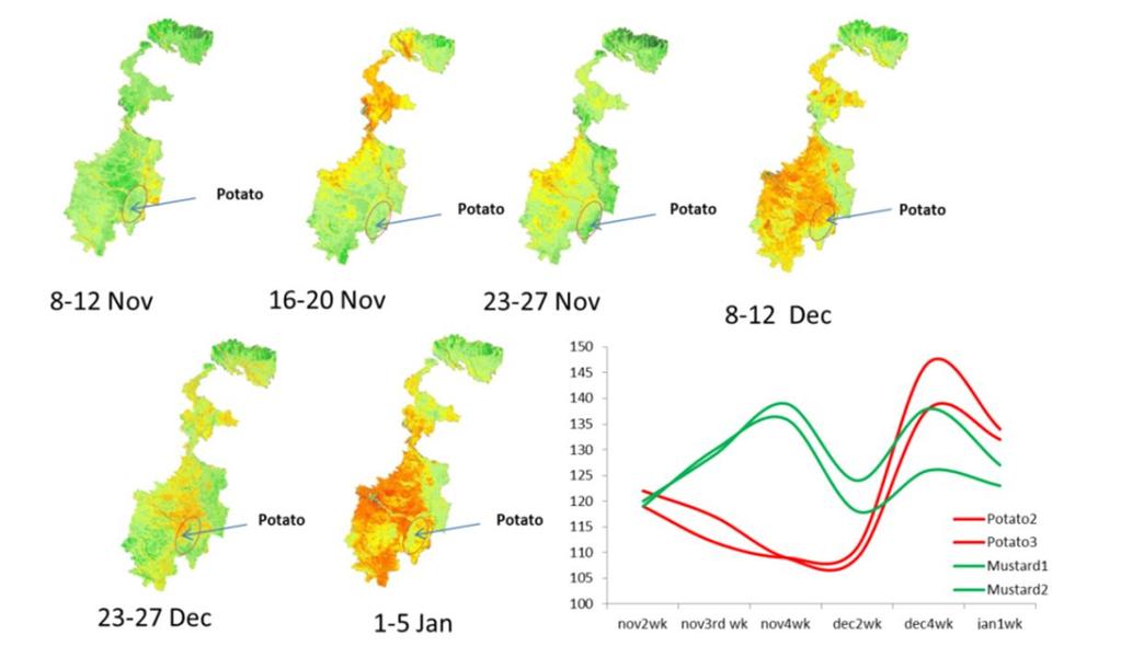
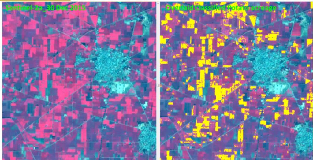
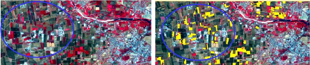
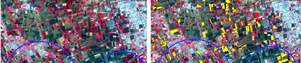
6 Potato Classification using AWiFS & Sentinel Data
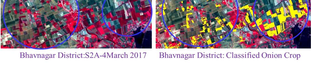
7 Onion Classification using Sentinel Data

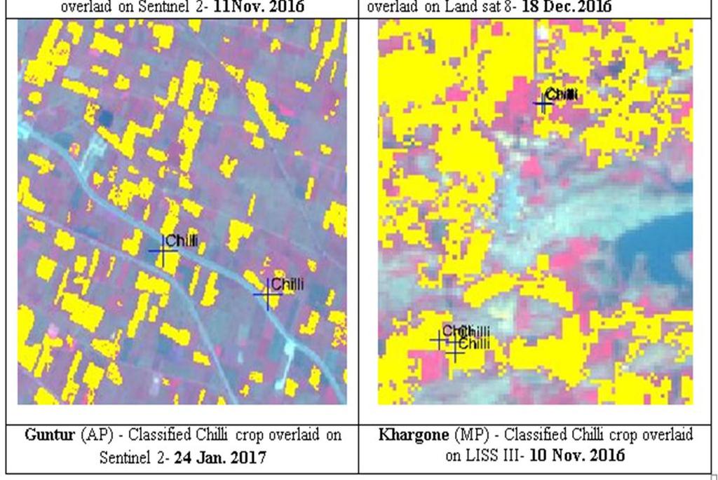
8 Tomato and Chilli Classification using LISS III/Sentinel/Landsat/LISS IV Data


9 Orchard Mapping using LISS IV/ LISS IV + Cartosat Data Citrus orchards in LISS IV data in Hoshiyarpur, Punjab Citrus orchards in LISS IV +Cartosat merged data in Bijapur, Karnataka Mango orchards in LISS IV + Cartosat merged data in Saharanpur District, UP Mango Orchards in LISS IV + Cartosat merged data in Sitapur, UP


10 MANGO ORCHARD Sitapur district of Uttar Pradesh 99_52_B_15 April 2013, LISS 4 FCC with Ground Truth points Classified Mango orchards overlaid on LISS 4 FCC with Ground Truth points IRS R-2 LISS-IV, Pixel based Classified output Refined Classified Output by manual editing over BHUVAN image as a Basemap IRS R-2 LISS-IV, Object based Classified output Classification Method Derived area (ha) Pixel based Object based BHUVAN Updated *Reference area (ha) Final Mango Orchards mapped for entire Sitapur district derived Mango Orchard area= ha

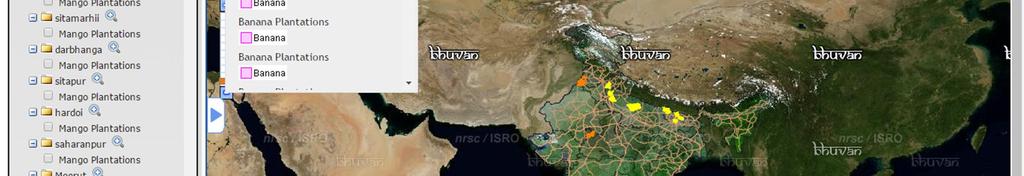
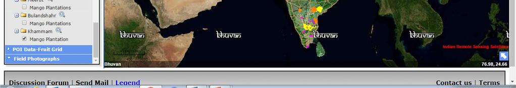
11 CHAMAN in BHUVAN Geoportal


12 Mango Orchard of Sitapur District, Bhuvan-CHAMAN Portal Scale: 1:15000 Scale: 1:5000
13 Deviation Analysis of Crop Statistics Crops MBE ('000 ha) RMSE ('000 ha) IA (unit less) ME (unit less) r 2 Number of data points Citrus Mango Banana Onion Potato
14 Horticultural Development using Geospatial Technology S.N. Component Activity 1 Site Suitability Introduction/expansion of Horticulture development activities in North Eastern States (One district in each state) 2 Post-Harvest Infrastructure Assessing the potential for new cold storage sites for in Bihar and UP State 3 Crop Intensification Understanding the scope of improving crop intensity through horticulture in selected districts of Haryana and Madhya Pradesh 4 GIS database creation Characterization of orchards and GIS database creation of various layers and uploading on Bhuvan platform 5 Orchard Rejuvenation Identifying plantations /orchards that needs Rejuvenation in one District in UP and One district of Karnataka/Gujarat/WB using remote Sensing data 6 Aqua-horticulture Developing plans for promoting aqua-horticulture in 1 2 districts in Bihar and Odisha state


15 Site Suitability Analysis for Horticulture Expansion in NER -States Land Suitability Analysis for Mango Plantation in Nuzvid mandal, AP Perspective view of Jhum land clusters Sl No State District Crop 1 Arunachal Papumpare Orange Pradesh 2 Assam Goalpara Banana 3 Manipur Senapati Pineapple 4 Meghalaya Jaintia Hills Turmeric 5 Mizoram Champhai Grape 6 Nagaland Dimapur Pineapple 7 Sikkim West Sikkim Cardamom 8 Tripura West Tripura Banana


16 Geospatial Applications: Post-Harvest Infrastructure Existing Proposed


 Number Area under Foxnut cultivation 339.")
17 Geospatial Applications: Aqua-Horticulture Legend Roads Railways!( Priority1 Villages # Priority2 Villages Major Towns District Boundary Potential Wetlands Priority 2 Potential Wetlands Priority 1 Makhana Ponds Not Potential Zones Category Area (Ha) Number Area under Foxnut cultivation Ponds under priority Ponds under priority


18 Geospatial Applications: Orchard Rejuvenation Potential Area Identification Based on NDVI Change Based on Orchard Structure


19 Geospatial Applications: Crop Intensification, Bhiwani, Haryana Full Seasonal Fallow 2015 Fallow Period 2015 Number of months Area(ha) 2015 Rabi 2015 Kharif 2015 Summer 1 month month month month Legend Annual Fallow Built_up Water Taluk Boundary


20 Precision Farming Study Study Area: Karsul Village, Niphad Taluk, Nasik Data Collected: Ground Spectral, UAV, High Resolution Satellite, Crop and Soil Parameters Activity: Phenology Mapping, Variability Assessment, Crop and Soil Parameter Retrieval
21 180 Normalized Difference Vegetation Index (NDVI) Temporal NDVI Profiles of Grapes with Varying Vigour Grape-Nov Fruit Pruning Low Vigour Grape-Nov Fruit pruning High Vigour Figure 5: Temporal spectral profile of grapes with varying vigour identified by stacking monthly NDVI Landsat imagery of , and for Karsul village, Niphad block, Nasik district Dates Normalized Difference Vegetation Index (NDVI) Temporal NDVI Profiles of Grapes with Varying Grape Young Orchard Phenology Grape-Oct Fruit pruning High Vigour Sept Fruit Pruning Oct Fruit Pruning Dates Nov Fruit Pruning Grape-Sept Fruit Pruning Low Vigour Grape-Nov Fruit pruning High Vigour Nov Fruit Oct Fruit Pruning Sept Fruit Pruning Pruning Figure 7: Temporal spectral profile of grapes with varying phenology identified by stacking monthly NDVI Landsat imagery of , and for Karsul village, Niphad block, Nasik district

22 Summary For crops like Potato, Mango, Citrus and Banana use of remote sensing data for assessment have been feasible, but for other crops accuracy is still an issue, due to scattered and small fields, mixed cropping, multiple seasons and short duration. Yield estimation for horticultural crops, especially fruit crops, is a problem due to multiple picking. However use of satellite data and geospatial tools has shown a great promise for horticultural development, especially for infrastructure development and horticultural expansion.
23 Acknowledgment Indian Space Research Organization (SAC, NRSC, NESAC) Department of Agriculture, Cooperation & Farmers Welfare (Hort Div) National Horticultural Research & Development Foundation India Meteorological Department State Horticulture Departments ICAR:NRCG Team Members 1. M M Kimothi 2. Seema Sehgal 3. Shreya Roy 4. Aditi Srivastava 5. Niti Singh 6. Gargi Upadhyay 7. Moreshwar Karale Thank you
Space Technology for Decision Support in Agriculture
 Space Technology for Decision Support in Agriculture Shibendu Shankar Ray Department of Agriculture, Cooperation & Farmers Welfare New Delhi 110 012, India www.ncfc.gov.in, shibendu.ncfc@nic.in Indian
Crop mapping with satellite data
 Crop mapping with satellite data Dr. C.S. Murthy Head, Agricultural Sciences and Applications National Remote Sensing Centre, Hyderabad murthy_cs@nrsc.gov.in, csmurthy09@gmail.com Geospatial Technology
FASAL: The Operational Programme for Crop Assessment in India
 FASAL: The Operational Programme for Crop Assessment in India 23 Jul, 17 Aug, 11 Sep 2015 13 Jul, 7 Aug, 1 Sep 2014 Neetu Mahalanobis National Crop Forecast Centre Ministry of Agriculture & Farmers Welfare,
Crop Assessment using Space, Agro-Meteorology & Land based observations : Indian Experience
 Crop Assessment using Space, Agro-Meteorology & Land based observations : Indian Experience Shibendu S. Ray Mahalanobis National Crop Forecast Centre Department of Agriculture, Cooperation & Farmers Welfare,
Remote Sensing for Agricultural Applications
 Remote Sensing for Agricultural Applications Shibendu S. Ray Mahalanobis National Crop Forecast Centre Department of Agriculture, Cooperation & Farmers Welfare, New Delhi shibendu.ncfc@gov.in GeoSmart
Operational Mapping and Monitoring of Agricultural Crops in India. Mahalanobis National Crop Forecast Centre
 Operational Mapping and Monitoring of Agricultural Crops in India MNCFC: An Introduction was established under Ministry of Agriculture & Farmers Welfare with technical and human resources support from
Use of Remote Sensing Technology in Crop Monitoring and Assessment of Impact of Natural Disaster
 Use of Remote Sensing Technology in Crop Monitoring and Assessment of Impact of Natural Disaster Shibendu S. Ray Mahalanobis National Crop Forecast Centre Department of Agriculture & Cooperation Government
Government of India s Perspective and Initiatives on Integration of Future Smart Food in Rice-Fallows
 Government of India s Perspective and Initiatives on Integration of Future Smart Food in Rice-Fallows Dr. B. Rajender, Joint Secretary (Crops & Oilseeds) Department of Agriculture, Cooperation & Farmers
Agricultural Drought Monitoring in India
 Agricultural Drought Monitoring in India with special emphasis on NADAMS Government of India Ministry of Agriculture & Farmers Welfare Department of Agriculture, Cooperation & Farmers Welfare Mahalanobis
MODULE 8 LECTURE NOTES 5 REMOTE SENSING APPLICATIONS IN DROUGHT ASSESSMENT
 MODULE 8 LECTURE NOTES 5 REMOTE SENSING APPLICATIONS IN DROUGHT ASSESSMENT 1. Introduction Drought is a phenomenon of long-term moisture deficiency. It may be meteorological, agricultural or hydrologic
APPLICATION OF GEO SPATIAL TECHNOLOGY IN AGRICULTURE
 APPLICATION OF GEO SPATIAL TECHNOLOGY IN AGRICULTURE Dr. S.C. Moharana Senior Scientist ORSAC, Bhubaneswar Training Programme on Applications of Geo-Spatial Technology Oct 14, 2017 FASAL Programme Implemented
SUBJECT: MINUTES OF THE MEETING OF THE CROP WEATHER WATCH GROUP HELD ON
 F. No. 31/ 201718CFCCE&S GOVERNMENT OF INDIA MINISTRY OF AGRICULTURE AND FARMERS WELFARE DEPARTMENT OF AGRICULTURE, COOPERATION AND FARMERS WELFARE (CROP FORECAST COORDINATION CENTRE) Room No. 344A, Krishi
Agricultural Crop Monitoring Programme in India
 Agricultural Crop Monitoring Programme in India Dr. Jai Singh Parihar Dy. Director Remote Sensing Applications Area (RESA) Space Applications Centre (ISRO) Ahmedabad 380 015 India jsparihar@sac.isro.gov.in
CHAPTER 2 FOREST COVER
 CHAPTER 2 FOREST COVER 2.1 Introduction Forest cover, as explained in the previous chapter, includes all lands more than 1 ha area having tree canopy density of 1 percent and above. The basic data for
Veena 1, Savita 2, Reetu Sharma 3 Sarvan 4. Haryana Space Applications Centre (HARSAC),
,") & Fruit Mapping of Adampur and Hisar-IInd Blocks of Hisar District Using On Screening Visual Interpretation Approach on WV-2 Data Veena 1, Savita 2, Reetu Sharma 3 Sarvan 4 Haryana Space Applications Centre
& Fruit Mapping of Adampur and Hisar-IInd Blocks of Hisar District Using On Screening Visual Interpretation Approach on WV-2 Data Veena 1, Savita 2, Reetu Sharma 3 Sarvan 4 Haryana Space Applications Centre
SUBJECT: MINUTES OF THE MEETING OF THE CROP WEATHER WATCH GROUP HELD ON
 F. No. 31/ 201718CFCCE&S GOVERNMENT OF INDIA MINISTRY OF AGRICULTURE AND FARMERS WELFARE DEPARTMENT OF AGRICULTURE, COOPERATION AND FARMERS WELFARE (CROP FORECAST COORDINATION CENTRE) Room No. 344A, Krishi
Forest Cover and Forest Area
 Forest Cover and Forest Area Chapter 3 FOREST COVER AND FOREST AREA The term 'Forest Area' (or recorded forest area) generally refers to all the geographic areas recorded as forest in government records.
Emerging Applications of RS & GIS in Agriculture
 Emerging Applications of RS & GIS in Agriculture Crop intensification (National Food Security Mission) Horticulture (National Horticulture Mission) High value crops (Commerce) Fibre Crop Information System
SUBJECT: MINUTES OF THE MEETING OF THE CROP WEATHER WATCH GROUP HELD ON
 F. No. 31/ 201819CFCCES GOVERNMENT OF INDIA MINISTRY OF AGRICULTURE AND FARMERS WELFARE DEPARTMENT OF AGRICULTURE, COOPERATION AND FARMERS WELFARE (CROP FORECAST COORDINATION CENTRE) Room No. 344A Krishi
Assessment of Irrigation Potential Utilization in Major Irrigation Project Using Geospatial Data
 Assessment of Irrigation Potential Utilization in Major Irrigation Project Using Geospatial Data Muthyam Shanker Abstract Many irrigation projects were constructed in India post-independence period spending
1 What are three cropping seasons of India? Explain any one in brief. 2 Discuss three main impacts of globalization on Indian agriculture.
 1 What are three cropping seasons of India? Explain any one in brief. 2 Discuss three main impacts of globalization on Indian agriculture. 3.Distinguish between rabi and kharif season? 4. What is Horticulture?
Soil Health Management in India
 Soil Health Management in India Soil Health Management in India Soil Health Management In order to improve the soil health of the Indian soils, gov- The nature and extent of deficiencies of nutrients in
Hand Book on Horticulture Statistics 2014
 Hand Book on Horticulture Statistics 2014 Government of India Ministry of Agriculture Department of Agriculture and Cooperation New Delhi Table of Contents Sl. No. Contents Page No. OVERVIEW 1 Socio-Economic
Confederation of Indian Industry. Opportunities in ORGANIC. Food in India. Ministry of Food Processing Industries. Government of India
 Confederation of Indian Industry Opportunities in ORGANIC Food in India Ministry of Food Processing Industries Government of India Advantage India One of the fastest growing economies in the world Largest
GOVERNMENT OF INDIA MINISTRY OF RURAL DEVELOPMENT DEPARTMENT OF LAND RESOURCES LOK SABHA STARRED QUESTION NO. 70 TO BE ANSWERED ON
 GOVERNMENT OF INDIA MINISTRY OF RURAL DEVELOPMENT DEPARTMENT OF LAND RESOURCES LOK SABHA STARRED QUESTION NO. 70 TO BE ANSWERED ON 20.07.2017 Development of Wasteland *70. SHRI KUNWAR PUSHPENDRA SINGH
Page 1 of 6. Agriculture. I. Answer the Following
 Agriculture Page 1 of 6 I. Answer the Following Q1. What is the importance of agriculture in the Indian economy? Ans. Two-thirds of India s population is engaged in agricultural activities. Agriculture
National Vegetable Initiative for Urban Clusters. Value chain integration, technology dissemination and accessing investments and markets
 National Vegetable Initiative for Urban Clusters Value chain integration, technology dissemination and accessing investments and markets Progress and Prospects Vegetable Initiative for Urban Clusters FPO
Remote sensing applications in natural resources mapping and management An Indian Context
 Remote sensing applications in natural resources mapping and management An Indian Context International Workshop on Operational Mapping/Monitoring of Agricultural Crops in South/Southeast Asian Countries
Volume -1, Issue-4 (October-December), 2013 Available online at popularkheti.info. Organic Farming: Current Status in India
, 2013 Available online at popularkheti.info. Organic Farming: Current Status in India") Popular Kheti Volume -1, Issue-4 (October-December), 2013 Available online at www.popularkheti.info 2013 popularkheti.info Organic Farming: Current Status in India Issue Special on Organic Farming ISSN:2321-0001
Popular Kheti Volume -1, Issue-4 (October-December), 2013 Available online at www.popularkheti.info 2013 popularkheti.info Organic Farming: Current Status in India Issue Special on Organic Farming ISSN:2321-0001
Need Additional Information? LEGAL DISCLAIMER ACKNOWLEDGEMENT:
 LEGAL DISCLAIMER This work was implemented as part of the CGIAR Research Program on Climate Change, Agriculture and Food Security (CCAFS) hosted by BISA-CIMMYT in South Asia. The views expressed in this
Guidelines for Implementation of fisheries Scheme under the National Mission for Protein Supplements (NMPS) in States during
 in States during") Annexure-III Guidelines for Implementation of fisheries Scheme under the National Mission for Protein Supplements (NMPS) in States during 2012-13 The Department of Animal Husbandry, Dairying & Fisheries,
Annexure-III Guidelines for Implementation of fisheries Scheme under the National Mission for Protein Supplements (NMPS) in States during 2012-13 The Department of Animal Husbandry, Dairying & Fisheries,
Wetlands of India: inventory and assessment at 1 : 50,000 scale using geospatial techniques
 Wetlands of India: inventory and assessment at 1 : 50,000 scale using geospatial techniques Sushma Panigrahy, T. V. R. Murthy*, J. G. Patel and T. S. Singh Conservation and wise use of wetlands has been
DSS for monitoring agro-meteorological and crop conditions in India using remote sensing for agro-advisory services. Montpellier March 16-18, 2015
 DSS for monitoring agro-meteorological and crop conditions in India using remote sensing for agro-advisory services Vinay Sehgal, Malti Singh, Rakeshwar Verma, Ananta Vashisth, Himanshu Pathak ICAR - Indian
Applications of Remote Sensing and Geographical Indication System in Land Resources Management
 Applications of Remote Sensing and Geographical Indication System in Land Resources Management Dr P. P. Nageswara Rao North Eastern Space Applications Centre, Umiam 793103, Meghalaya A natural resource
Remote Sensing Uses in Agriculture at NASS
 Remote Sensing Uses in Agriculture at NASS United States Department of Agriculture (USDA) National Agriculture Statistics Service (NASS) Research and Development Division Geospatial Information Branch
GOVERNMENT OF INDIA MINISTRY OF TRIBAL AFFAIRS
 GOVERNMENT OF INDIA MINISTRY OF TRIBAL AFFAIRS Status report on implementation of the Scheduled Tribes and Other Traditional Forest Dwellers (Recognition of Forest Rights) Act, 2006 [for the period ending
(i) GOVERNMENT OF INDIA MINISTRY OF TRIBAL AFFAIRS
 GOVERNMENT OF INDIA MINISTRY OF TRIBAL AFFAIRS") GOVERNMENT OF INDIA MINISTRY OF TRIBAL AFFAIRS Status report on implementation of the Scheduled Tribes and Other Traditional Forest Dwellers (Recognition of Forest Rights) Act, 2006 [for the period ending
GOVERNMENT OF INDIA MINISTRY OF TRIBAL AFFAIRS Status report on implementation of the Scheduled Tribes and Other Traditional Forest Dwellers (Recognition of Forest Rights) Act, 2006 [for the period ending
DATA Analytics of Agriculture Production, Wages and Income in Rural Areas of India using Big Data and Python Matplot Lib
 DATA Analytics of Agriculture Production, Wages and Income in Rural Areas of India using Big Data and Python Matplot Lib K. Raghavendra Swamy Technical Trainer BDPS PVT LTD. VIJAYAWADA. swamy1712@gmail.com
CROPPING SYSTEM ANALYSIS USING REMOTE SENSING AND GIS: A BLOCK LEVEL STUDY OF KURUKSHETRA DISTRICT
 CROPPING SYSTEM ANALYSIS USING REMOTE SENSING AND GIS: A BLOCK LEVEL STUDY OF KURUKSHETRA DISTRICT M. P. Sharma 1, Manoj Yadav 1, R. Prawasi 1, Pavan Kumar 2 and R. S. Hooda 1 1 Haryana Space Applications
Confederation of Indian Industry. Opportunities in. Fisheries. Sector in India. Ministry of Food Processing Industries. Government of India
 Confederation of Indian Industry Opportunities in Fisheries Sector in India Ministry of Food Processing Industries Government of India Advantage India One of the fastest growing economies in the world
Status of Production of Horticultural Crops of NER, with Special Reference to Assam
 Status of Production of Horticultural Crops of NER, with Special Reference to Assam Assistant Professor, Dispur College A B S T R A C T The North-East Region of Indiaconstitutes the states of Arunachal
Multi temporal remote sensing for yield prediction in sugarcane crops
 Multi temporal remote sensing for yield prediction in sugarcane crops Dr Moshiur Rahman and A/P Andrew Robson (Principal Researcher) Precision Agriculture Research Group, University of New England, NSW,
MEMBERS' REFERENCE SERVICE LARRDIS LOK SABHA SECRETARIAT, NEW DELHI REFERENCE NOTE. No.56/RN/Ref./Nov/2017
 MEMBERS' REFERENCE SERVICE LARRDIS LOK SABHA SECRETARIAT, NEW DELHI REFERENCE NOTE No.56/RN/Ref./Nov/2017 For the use of Members of Parliament NOT FOR PUBLICATION 1 DAIRY SECTOR: PRESENT SCENARIO AND NEW
National Afforestation Programme (NAP) Scheme: At A Glance
 Scheme: At A Glance") National Afforestation Programme (NAP) Scheme: At A Glance (1) Background: MoEF was operating four centrally sponsored afforestation schemes during the 9 th Plan, i.e. Integrated Afforestation and Eco-development
National Afforestation Programme (NAP) Scheme: At A Glance (1) Background: MoEF was operating four centrally sponsored afforestation schemes during the 9 th Plan, i.e. Integrated Afforestation and Eco-development
EXTERNALLY FUNDED PROJECTS
 EXTERNALLY FUNDED PROJECTS PLANT BREEDING Sl. Name of the project start Present status 1 NAIP on Bioprospecting 2009 On going and allele mining 2. DBT project on Quality Protein Maize 2009 2014 On going
REGIONAL CONVERGENCE IN AGRICULTURE GROWTH IN INDIA: A STATE LEVEL ANALYSIS
 REGIONAL CONVERGENCE IN AGRICULTURE GROWTH IN INDIA: A STATE LEVEL ANALYSIS Anju Rani Research Scholar, Dept. of economics, Central University of Haryana Dr. Ranjan Aneja Head, Assistant Professor, Dept.
GOVERNMENT OF INDIA MINISTRY OF ENVIRONMENT, FOREST AND CLIMATE CHANGE LOK SABHA UNSTARRED QUESTION NO.2282 TO BE ANSWERED ON
 GOVERNMENT OF INDIA MINISTRY OF ENVIRONMENT, FOREST AND CLIMATE CHANGE LOK SABHA UNSTARRED QUESTION NO.2282 TO BE ANSWERED ON 29.11.2016 Common Effluent Treatment Plants 2282. DR. C.GOPALAKRISHNAN: PROF.
Group 3: Anuradha Rucku Gupta Marvis Dan Xiao Duong Nguyen Van
 Group 3: Anuradha Rucku Gupta Marvis Dan Xiao Duong Nguyen Van Introduction Agriculture has been the basic source for the subsistence of man for thousand of years. Even today, it provides livelihood to
22: List of Studies Conducted by Agro-Economic Research Centres
 22: List of Studies Conducted by Agro-Economic Research Centres 2006-07 1 India s Global Tea Trade Reducing Share, Declining Competitiveness. 2 Developing India s Strategic Responses to the Global Debate
Sunil Jain, Sankarsana Sahoo, Kumar Sundaram, Pramod Kumar
 Sunil Jain, Sankarsana Sahoo, Kumar Sundaram, Pramod Kumar Plan of Presentation Methodology of GVA Estimation of Crop Sector Methodology for GVA of Crop sector on Financial Year basis. Methodology for
DEVELOPMENT PROGRAMMES ON PULSES: GOVERNMENT EFFORTS
 DEVELOPMENT PROGRAMMES ON PULSES: GOVERNMENT EFFORTS India is a major Pulses growing country in the world. Pulses account for about one-fifth of the total acreage under food grains and about one-fifteenth
STUDY OF CROPPING SYSTEMS DYNAMICS IN THE LOWER GANGETIC PLAINS OF INDIA USING GEOSPATIAL TECHNOLOGY
 STUDY OF CROPPING SYSTEMS DYNAMICS IN THE LOWER GANGETIC PLAINS OF INDIA USING GEOSPATIAL TECHNOLOGY K.R. Manjunath*, Nitai Kundu, S.S. Ray 1, Sushma Panigrahy, and J.S. Parihar Earth, Ocean, Atmosphere,
Mapping smallholder agriculture using simulated Sentinel-2 data; optimization of a Random Forest-based approach and evaluation on Madagascar site
 Mapping smallholder agriculture using simulated Sentinel-2 data; optimization of a Random Forest-based approach and evaluation on Madagascar site Lebourgeois, V., Dupuy, S., Vintrou, E., Ameline, M., Butler,
Horticulture State at a Glance: Manipur, Vol. 1(8), : Value of Output of Horticulture, Fruits and Vegetables and Condiments & Spices
, : Value of Output of Horticulture, Fruits and Vegetables and Condiments & Spices") Horticulture List of Tables 8.1: Area under Fruits and Vegetables 8.2: Horticulture Production 8.3: Area and Production of Horticultural Crops 8.4: Area and Production of Crops 8.5: Area and Production
Horticulture List of Tables 8.1: Area under Fruits and Vegetables 8.2: Horticulture Production 8.3: Area and Production of Horticultural Crops 8.4: Area and Production of Crops 8.5: Area and Production
Status of Legal Reforms in Agricultural Marketing
 Advances in Social Research: 3(2): 55-59, December 2017 Status of Legal Reforms in Agricultural Marketing Nitu Mehta(Ranka) and Latika Sharma* Department of Agricultural Economics & Management, Rajasthan
Inter-state Disparities in Socio-economic Development in North East Region of India
 Journal of Agricultural Science; Vol. 4, No. 9; 2012 ISSN 1916-9752 E-ISSN 1916-9760 Published by Canadian Center of Science and Education Inter-state Disparities in Socio-economic Development in North
Trends of Non-Foodgrains Cultivation in India: A State Level Analysis
 Trends of Non-Foodgrains Cultivation in India: A State Level Analysis Samir Show Research Scholar, Department of Economics, Vidyasagar University. Received: June 01, 2018 Accepted: July 26, 2018 ABSTRACT
02. Which among the following species in india are accorded critically endangered status by IUCN?
 0 Which of the following countries have recently achieved Malariafree status? Maldives Sri Lanka Kyrgyztan Select the correct answer from the given codes. Answer : d b. 2 and 3 only WHO certifies Malari-free
Crop monitoring and yield forecasting MARS activities in Asia
 Crop monitoring and yield forecasting MARS activities in Asia Rémi Lecerf European Commission, Joint Research Centre GLOBCAST dissemination event Conference Centre Albert Borschette Brussels, 30 September
Assessment of Tree Resources Outside Forest Based on Remote Sensing Satellite Data
 Assessment of Tree Resources Outside Forest Based on Remote Sensing Satellite Data Dr. J.K. Rawat 1, Saibal Dasgupta 2 & Rajesh Kumar 3 Introduction Forests have gained an important place in international
Experts estimates that demand for food crops will
 International Journal of Agricultural Engineering, Vol. 3 No. 2 (October, 2010) : 360-364 A Case Study: Estimation of crop and irrigation water requirement by remote sensing and CIS: Kaithal District,
FOREST COVER MAPPING AND GROWING STOCK ESTIMATION OF INDIA S FORESTS
 FOREST COVER MAPPING AND GROWING STOCK ESTIMATION OF INDIA S FORESTS GOFC-GOLD Workshop On Reducing Emissions from Deforestations 17-19 April 2007 in Santa Cruz, Bolivia Devendra PANDEY Forest Survey of
Satellite image classification of vegetation and surface water for assessment of flood damage to agricultural crops
 Satellite image classification of vegetation and surface water for assessment of flood damage to agricultural crops Lisa Colson 2, Mark Lindeman 1, Dath Mita 1, Tatiana Nawrocki 2, Paulette Sandene 1,
Quantification of agricultural landuse during Kharif and Rabi season of Datia district, Madhya Pradesh, India
 47 Quantification of agricultural landuse during Kharif and Rabi season of Datia district, Madhya Pradesh, India Pushpendra Singh Rajpoot 1, Ajay Kumar 1 and Sandeep Goyal 2 1 Department of Physical Sciences,
International Journal of Advance ISSN and Applied Research (IJAAR) Impact Factor 0.899
 Impact Factor 0.899") International Journal of Advance ISSN 2347-7075 and Applied Research (IJAAR) Impact Factor 0.899 Peer Reviewed Bi-Monthly Vol.2 No.1 Sept- Oct 2014 INSTALLATION OF OFF-GRID RENEWABLE ENERGY SYSTEMS IN
International Journal of Advance ISSN 2347-7075 and Applied Research (IJAAR) Impact Factor 0.899 Peer Reviewed Bi-Monthly Vol.2 No.1 Sept- Oct 2014 INSTALLATION OF OFF-GRID RENEWABLE ENERGY SYSTEMS IN
GOVERNMENT OF INDIA MINISTRY OF FOOD PROCESSING INDUSTRIES LOK SABHA UNSTARRED QUESTION NO.890 ANSWERED ON 1 ST MARCH, WASTAGE OF AGRO-PRODUCTS
 GOVERNMENT OF INDIA MINISTRY OF FOOD PROCESSING INDUSTRIES LOK SABHA UNSTARRED QUESTION NO.890 ANSWERED ON 1 ST MARCH, 2016. WASTAGE OF AGRO-PRODUCTS 890. SHRI CHARANJEET SINGH RORI: SHRI RAMESH CHANDER
Potential Gains from Regional Cooperation and Trade of Electricity in South Asia
 Potential Gains from Regional Cooperation and Trade of Electricity in South Asia Govinda R. Timilsina and Mike Toman The World Bank, Washington, DC 5 th Asian Conference of IAEE University of Western Australia
ArcGIS Agricultural Land-Use Maps: The Mississippi Cropland Data Layer Fred L. Shore, Ph.D., Thomas L. Gregory, and Rick Mueller
 ESRI Federal User Conference, 1/31/06-2/02/06, Washington, D.C. ArcGIS Agricultural Land-Use Maps: The Mississippi Cropland Data Layer Fred L. Shore, Ph.D., Thomas L. Gregory, and Rick Mueller Abstract:
Linking smallholders to the agri value chain
 Linking smallholders to the agri value chain Venture Capital Assistance Scheme Small Farmers Agribusiness Consortium (Dept. of Agriculture and Cooperation) Govt. of India लघ क षकक ष य प रस घ भ रतसरक र,
OneCert Asia: Company Profile
 OneCert Asia: Company Profile Vision: OneCert s goal is to provide the best value in certification services. Mission: Mission of OneCert can be stated as follows: To have accreditations for all major-minor
NO:-32-20/2017-NDM-I Ministry of Home Affairs (Disaster Management Division)
") [ NO:-32-20/2017-NDM-I Ministry of Home Affairs (Disaster Management Division) SITREP NO. 56/2017 26/07/2017 (1515 Hours) Sub:- MONSOON-2017: DAILY MONSOON / FLOOD SITUATION REPORT 1. CENTRAL WATER COMMISSION
[ NO:-32-20/2017-NDM-I Ministry of Home Affairs (Disaster Management Division) SITREP NO. 56/2017 26/07/2017 (1515 Hours) Sub:- MONSOON-2017: DAILY MONSOON / FLOOD SITUATION REPORT 1. CENTRAL WATER COMMISSION
COMPARATIVE STUDY OF NDVI AND SAVI VEGETATION INDICES IN ANANTAPUR DISTRICT SEMI-ARID AREAS
 International Journal of Civil Engineering and Technology (IJCIET) Volume 8, Issue 4, April 2017, pp. 559 566 Article ID: IJCIET_08_04_063 Available online at http://www.iaeme.com/ijciet/issues.asp?jtype=ijciet&vtype=8&itype=4
Drought monitoring experiences of India
 REGIONAL WORKSHOP ON UNDERSTANDING THE OPERATIONAL ASPECTS OF THE DROUGHT OBSERVATION SYSTEM IN MONGOLIA, 17 Sep 2018 Drought monitoring experiences of India Dr. C.S. Murthy Head, Agricultural Sciences
GOVERNMENT OF INDIA MINISTRY OF TRIBAL AFFAIRS
 MOST IMMEDIATE GOVERNMENT OF INDIA MINISTRY OF TRIBAL AFFAIRS Subject: Monthly update on status of implementation of the Scheduled Tribes and Other Traditional Forest Dweller (Recognition of Forest Rights)
Dynamics of Land Use Competition in India: Perceptions and Realities. Vijay Paul Sharma
 INDIAN INSTITUTE OF MANAGEMENT AHMEDABAD INDIA Dynamics of Land Use Competition in India: Perceptions and Realities Vijay Paul Sharma W.P. No. 2015-06-02 June 2015 The main objective of the working paper
GIS STUDY OF THE DIVERSITY OF GINGER CULTIVATION IN INDIA Utpala P, Johny A.K, V.A.Parthasarathy, K.Jayarajan and M.S.Madan
 GIS STUDY OF THE DIVERSITY OF GINGER CULTIVATION IN INDIA Utpala P, Johny A.K, V.A.Parthasarathy, K.Jayarajan and M.S.Madan Ginger is reported to have originated in Southern China. Today, it is cultivated
MEMBERS' REFERENCE SERVICE LARRDIS LOK SABHA SECRETARIAT, NEW DELHI LEGISLATIVE NOTE. No.47/LN/Ref./November/2017
 MEMBERS' REFERENCE SERVICE LARRDIS LOK SABHA SECRETARIAT, NEW DELHI LEGISLATIVE NOTE No.47/LN/Ref./November/2017 For the use of Members of Parliament NOT FOR PUBLICATION 1 THE ANCIENT MONUMENTS AND ARCHAEOLOGICAL
Remote sensing in irrigated onion production: Challenges & opportunities
 Remote sensing in irrigated onion production: Challenges & opportunities Hort Connections 2017 Adelaide Convention Centre Michael Cutting, Natural Resources SA MDB Region Project Background: In 2004/05
NABARD Consultancy Services Private Limited (An ISO 9001:2008 Company) A Wholly owned subsidiary of NABARD
 A Wholly owned subsidiary of NABARD") NABARD Consultancy Services Private Limited (An ISO 9001:2008 Company) A Wholly owned subsidiary of NABARD NABARD Consultancy Services Private Limited, a wholly owned subsidiary of NABARD, invites online
NABARD Consultancy Services Private Limited (An ISO 9001:2008 Company) A Wholly owned subsidiary of NABARD NABARD Consultancy Services Private Limited, a wholly owned subsidiary of NABARD, invites online
PROGRAMMES AND SCHEMES Monsoon and Crop Sowing Situation during Kharif-2012
 PROGRAMMES AND SCHEMES Monsoon and Crop Sowing Situation during Kharif-2012 As per India Meteorological Department (IMD) data SW Monsoon rainfall for the country as a whole during June- September, 2012
Cooperative Banking : Challenges And Opportunities. By Dr. Vigneshwara Varmudy Associate Professor in Economics Vivekananda College Puttur
 Cooperative Banking : Challenges And Opportunities By Dr. Vigneshwara Varmudy Associate Professor in Economics Vivekananda College Puttur The Indian cooperative sector is 109 years old. Government took
Instruction for filling the AIN application form
 Instruction for filling the AIN application form 1. Form is to be filled legibly in ENGLISH in BLOCK LETTERS. 2. While filling the form, each box, wherever provided, should contain only one character (alphabet/number/punctuation
6. LAND RESOURCES : AGRICULTURE
 6. LAND RESOURCES : AGRICULTURE 38 MT EDUCARE LTD. Q.1 (A) Choose the correct alternative from the brackets and rewrite the statements : 1. India ranks... in the world regarding area under cultivation.
Collaboration of Space Research Institute NASU-SSAU with EC JRC on satellite monitoring for food security: background and prospects
 Collaboration of Space Research Institute NASU-SSAU with EC JRC on satellite monitoring for food security: background and prospects Prof. Nataliia Kussul 1 Space Research Institute NASU-SSAU, Ukraine Context
ESTIMATION OF POSTHARVEST LOSSES OF SOLANACEOUS VEGETABLES AT DIFFERENT LEVELS IN JABALPUR MADHYA PRADESH INDIA. ** Emeritus scientist at UGC.
 DOI: 10.21276/ijabpt.2016.7.4.16 Volume-7, Issue-4, Oct-Dec-2016 Coden IJABFP-CAS-USA Copyrights@2016 Received: 12 th Aug 2016 Revised: 27 th Sept 2016 Accepted: 29 th Sept 2016 DOI: 10.21276/Ijabpt, http://dx.doi.org/10.21276/ijabpt
DictionaryKnowledge Based Classifier for Wetland Features Extraction Using MODIS Data: A Case Study in Gujarat
 Sengupta, M. and Dalwani, R. (Editors). 2008 Proceedings of Taal2007: The 12 th World Lake Conference: 647-652 DictionaryKnowledge Based Classifier for Wetland Features Extraction Using MODIS Data: A Case
Five-fold increase in food grains production since Moved away from food dependency to a net food exporter Largest producer of milk, annual
 May 2, 2017 Outline Agriculture in India- An overview Significance of Agricultural Statistics Release of national level estimates Validation of Data Collection of primary data by States Othersources of
Confederation of Indian Industry. Opportunities in. Ministry of Food Processing Industries. Government of India
 Confederation of Indian Industry Opportunities in DAIRY Sector in India Ministry of Food Processing Industries Government of India Advantage India One of the fastest growing economies in the world Largest
CROP DIVERSIFICATION AND FARM INCOME IN THE HILLS OF NORTH EAST INDIA: A CASE OF ARUNACHAL PRADESH
 CROP DIVERSIFICATION AND FARM INCOME IN THE HILLS OF NORTH EAST INDIA: A CASE OF ARUNACHAL PRADESH *Maila Lama Department of Economics, Rajiv Gandhi University, Itanagar, Arunachal Pradesh, India *Author
Status of Poverty in India A State wise Analysis
 Status of Poverty in India A State wise Analysis Dr Waheeda Sunny Thomas Faculty Economics, SEMCOM, Gujarat, India ABSTRACT First millennium development goal is to eradicate extreme poverty and hunger.
Parliament of India for SSC & Bank Exams - GK Notes in PDF
 Parliament of India for SSC & Bank Exams - GK Notes in PDF We all know that India is a democratic country and the Parliament of India is the highest legislative body of India. By and large, the Indian
Chapter 4 Agriculture
 Chapter 4 Agriculture Types of Farming Primitive Subsistence Farming Practiced on small patches of land. Involves family/community labour. Uses primitive tools such as hoe, digging sticks etc. Predominance
State wise analysis of RPO Regulation for Captive users
 State Regulation for Captive Users Definition of renewable Energy as per the commission order Remarks Andhra Pradesh Every consumer owning a captive generating plant of installed capacity of one (1) MW
MAPPING OF TREE OUTSIDE FOREST IN KALESAR BLOCK (YAMUNANAGAR DISTRICT, HARYANA) USING GEO-INFORMATICS TECHNIQUES
 USING GEO-INFORMATICS TECHNIQUES") International Journal of Science, Environment and Technology, Vol. 3, No 5, 2014, 1835 1842 ISSN 2278-3687 (O) MAPPING OF TREE OUTSIDE FOREST IN KALESAR BLOCK (YAMUNANAGAR DISTRICT, HARYANA) USING GEO-INFORMATICS
International Journal of Science, Environment and Technology, Vol. 3, No 5, 2014, 1835 1842 ISSN 2278-3687 (O) MAPPING OF TREE OUTSIDE FOREST IN KALESAR BLOCK (YAMUNANAGAR DISTRICT, HARYANA) USING GEO-INFORMATICS
GOVERNMENT OF INDIA MINISTRY OF ENVIRONMENT, FOREST AND CLIMATE CHANGE. LOK SABHA STARRED QUESTION No. 334 TO BE ANSWERED ON
 GOVERNMENT OF INDIA MINISTRY OF ENVIRONMENT, FOREST AND CLIMATE CHANGE LOK SABHA STARRED QUESTION No. 334 TO BE ANSWERED ON 09.08.2016 Ecological Impact of Mining *334. SHRI JANARDAN SINGH SIGRIWAL state:
RESULTS- STUDY OF COLD STORAGES
 Study of Cold i RESULTS- STUDY OF COLD STORAGES SFAC Scheme for Agribusiness Development provides interest-free Venture Capital to setup agribusiness projects and Project Development facility to assist
National Agromet Advisory Service Bulletin Based on Extended Range Weather Forecast (ERFS)
") National Agromet Advisory Service Bulletin Based on Extended Range Weather Forecast (ERFS) Validity for 11 th to 24 th May 2018 Date of issue: 11 th May 2018 Issued by Indian Council of Agricultural Research
National Agromet Advisory Service Bulletin Based on Extended Range Weather Forecast (ERFS) Validity for 11 th to 24 th May 2018 Date of issue: 11 th May 2018 Issued by Indian Council of Agricultural Research
Certification, Value Chain Development and Marketing of Organic Products with Special Reference to PKVY and MOVCDNER scheme.
 Certification, Value Chain Development and Marketing of Organic Products with Special Reference to PKVY and MOVCDNER scheme Group-Vl Participating States/Agencies MOVCDNER STATES PKVY STATES AGENCIES Arunachal
SFAC Presentation on Venture Capital Assistance. Updated on
 SFAC Presentation on Venture Capital Assistance Scheme Updated on 27.10.2014 About SFAC SFAC is a Society established by DAC, GOI, chaired by Hon. Agriculture Minister RBI, NABARD, PSBs are original promoters
VISION DOCUMENT FOR 12TH FIVE YEAR PLAN
 National Afforestation & Eco-development Board, Ministry of Environment & Forests, Government of India VISION DOCUMENT FOR 12TH FIVE YEAR PLAN RCNAEB, BHOPAL Indian Institute of Forest Management, Bhopal