TheCounty. LEAR A Method for Determining Prime Agricultural Designations in Prince Edward County
|
|
|
- Adela Dean
- 5 years ago
- Views:
Transcription
1 LEAR A Method for Determining Prime Agricultural Designations in Prince Edward County
2 Background The County of Prince Edward has been undertaking a comprehensive review of its Official Plan. The Province has requested Prince Edward County to review its designations of Prime Agriculture and Rural through the application of a LEAR Study.
3 Statutory Basis The need to identify Prime Agricultural areas is based on the Provincial Policy Statement (PPS), 2014 issued under Section 3 of the Planning Act: Prime agricultural areas shall be protected for long-term use for agriculture. Prime agricultural areas are areas where prime agricultural lands predominate. Specialty crop areas shall be given the highest priority for protection, followed by Canada Land Inventory Class 1, 2, and 3 lands, and any associated Class 4 through 7 lands within the prime agricultural area, in this order of priority Planning authorities shall designate prime agricultural areas and specialty crop areas in accordance with guidelines developed by the Province, as amended from time to time.
4 Land Evaluation and Area Review (LEAR) is the primary method recognized and accepted by the Province for completing reviews of Prime Agricultural and Rural designations. Provincial guidelines for to be used, A Guide to Land Evaluation and Area Review (LEAR) System for Agriculture
5 Stages to Developing Prime Agricultural Designations Main Criterion: Evaluated areas (i.e. LEAR) have a predominance of CLI Soil Classes 1, 2, and 3 as per PPS, including associated areas of farming concentration. Identify significant (large acreages) and contiguous Blocks of Prime Agricultural lands; Demarcate Blocks of Prime Agricultural lands by way of recognizable features, such as roadways.
6 LEAR Steering Committee Provincial LEAR guidelines direct that a LEAR Steering Committee be established by the municipality. Representatives of the agricultural community who have local knowledge (soils and farming practices) sit on the LEAR Committee and assist in the adaptation of the LEAR guidelines. A representative of the Ministry of Agriculture, Food and Rural Affairs (OMAFRA) must also sit on the Committee. The County also relied on the retained consulting services of Mr. Jim Dyment, RPP then of MHBC Planning Ltd. and his associate Mr. Dave Hodgson, a qualified agrologist of DBH Soil Services.
7 So, what is LEAR? In general terms, LEAR is an objective and systematic approach to assessing lands for determining its potential to form a Prime Agricultural designation. LEAR is an acronym representing two components of assessment: Land Evaluation (LE) and Area Review (AR). Each part contributes up to a maximum of 100 points towards an ideal total agricultural score of 200 points per evaluation unit. LE + AR = Total Score Areas having a high score are candidates for a Prime Agricultural designation.
8 Scope of the Study Area The evaluation is generally applied to all rural areas with some exceptions. In the Prince Edward County LEAR Study, Urban, Aggregate, Hamlet and Shore Land designations, and publicly owned lands including provincial and federal lands were not subject to LEAR evaluations.
9 LEAR - LE Component The LE component analyzes information presented in the Canada Land Inventory (CLI) system of Soil Capability for Common Field Crops. Areas of good soil need to be measured distinctively from poor soils. First, a unit of evaluation needs to be chosen as a basis for scoring and ranking areas. For example, options can include: parcels of ownership the original Crown Lot blocks of land defined by road and road allowance patterns, or, other units that make for a consistent representation of lands to be scored based on soil classes. In Prince Edward County s LEAR Study, parcels of ownership were selected as the evaluation unit.
10 LEAR - LE Scoring Each parcel of ownership was given a score. As per LEAR, a rank weighting system was applied. For example, a maximum of 100 points is scored for Class 1 soil, Class 2 soils is scored a weight of 0.9 points, Class 3 soils is scored a weight of 0.8 points, etc. For all parcels in the study area of the County, the LE scores were tallied. For example, a 100-acre parcel of land with 50 acres of Class 1 soils (1.0 weight) and 50- acres of Class 3 soil (0.8 weight) would be given a score of 1.0 x 50-acres (50 points) x 50-acres (40 points) for a Total of 90 points.
11
12 LEAR - AR Component The Area Review part of the LEAR formula measures the capability of a parcel for agricultural uses based on four factors that are individually scored. The factors function as mitigating considerations: 1. Large Parcel Size to a maximum of 12.5 points 2. Currently farmed if yes, 50 points, if not 0 points 3. Percent of the parcel that is farmed to a maximum of 25 points 4. Number of conflicting land uses within 1,000 metres to a maximum of 12.5 points for a parcel with no conflicting uses

13 LEAR - AR Component The number of points or weight assigned to each factor reflects decisions made by the Steering Committee. This flexibility in the LEAR methodology serves to tailor the study to local conditions in each municipality. A strong reliance on utilizing GIS data and aerial imagery is needed.
14 Total Scores A principal determination was the threshold value (total score) that would rank a parcel as a candidate for either the Prime Agricultural designation or the Rural designation. Again, after some testing and public feedback, the threshold value chosen by the Committee was 140. Scores greater than or equal to 140 points qualify as prime agricultural, provided the LE (soil) score was greater than or equal to 70 points. Parcel scores below LEAR 140 and LE 70 were considered to be rural rather than prime agricultural.

15 LEAR Scoring
16 Calibrations, Refinements and Reiterations Significant testing and re-testing of scoring weights was required to offer representativeness of areas of known as good farming before the Committee accepted the weightings in the final LEAR formula.
17 Calibrations, Refinements and Reiterations According to the OMAFRA guidelines, the minimum numerical weight given to the land evaluation (LE) factor is 50 percent. LEAR Steering Committees may choose a higher relative weighting. Steering Committees may also adjust the relative weights of each Soil Class, e.g. assign the same weight to each of Class 1 and Class 2 or other considerations based on local knowledge. Similarly, the Committee worked to find appropriate weightings for the AR Component, in context with Provincial guidelines.
18 Calibrations, Refinements and Reiterations Through Committee feedback, the CLI Soils mapping was determined to be useful but perhaps subject to inaccuracies in some areas. The LEAR consultant and agrologist visually inspected certain priority areas to the extent permitted by study resources. MPAC soils data were investigated by staff and determined to be quite accurate in many cases. The Committee chose to utilize MPAC soil data in order to assist in interpreting CLI Soils mapping. MPAC data proved very useful for both the LE and AR components.
19 Calibrations, Refinements and Reiterations Remote crop sensing data (AAFC) were used to identify where common crops were produced in Canada Land Inventory data were updated using OMAFRA LiDAR technology to aid in improving accuracy of the LE scores.
20 Blocks and Boundaries the Prime Agricultural Designation Parcels evaluated to have scores qualifying for a Prime agricultural designation were mapped into consolidated Blocks of land. Due to the predominance test, the Province advised that Blocks of large areas were to be in the neighbourhood of 250 hectares (600 acres) or larger. The soils in TheCounty are quite variable and the Committee and the public had difficulty in understanding the Block approach. Within a Block, significant areas of poor soils could be found and conversely, areas outside of the Prime Agriculture Block had significant areas of good soils. LEAR guidelines permit smaller Blocks to reflect local circumstances. The LEAR Committee accepted 150 ha as an appropriate Block area to better reflect variable soil conditions.

21 LEAR Scores Revised with Compensation Factors and Updated Soil Data
22 Community Consultation A total of four public Open Houses were held over a period of time, beginning in October 2016 through to March Public turn-out was always good. Community input influenced the LEAR Study significantly, including: the relative weighting of scores the lowering of the minimum Block size determinations the choosing of boundaries used to demarcate the Prime Agriculture designation.
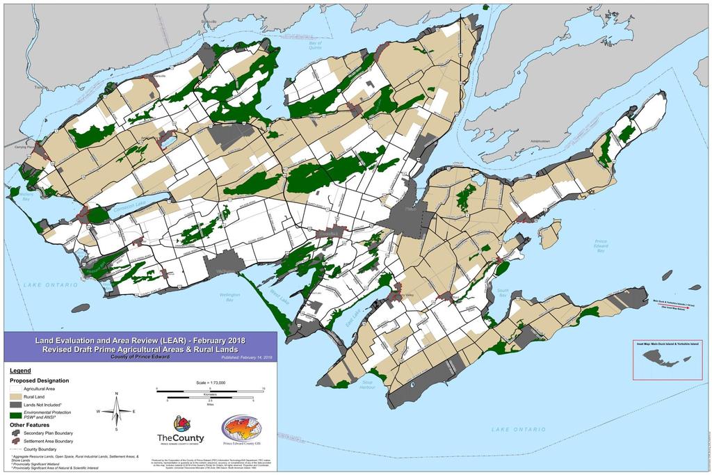
23 Final Block Designations
24 Next Steps In March, County Council motioned to send the draft Official Plan, including the Prime Agricultural and Rural designations mapping, to the Ministry of Municipal Affairs for One-Window review. Stay Tuned!
25 Acknowledgements Presented materials included excerpts from the reports drafted by: Mr. Jim Dyment, RPP, Consultant Mr. Bernard Shalka, County Official Plan Project Manager Mr. Grant Hopkins, County GIS Coordinator
26 Questions?
Land Evaluation & Area Review (LEAR) Study and Minimum Distance Separation (MDS) Review
 Study and Minimum Distance Separation (MDS) Review") These displays were presented at the Public Information Open House for the Land Evaluation & Area Review (LEAR) Study and Minimum Distance Separation (MDS) Review April 3, 2014 7pm-9pm Brampton Fairgrounds,
These displays were presented at the Public Information Open House for the Land Evaluation & Area Review (LEAR) Study and Minimum Distance Separation (MDS) Review April 3, 2014 7pm-9pm Brampton Fairgrounds,
THE REGION OF PEEL & TOWN OF CALEDON LAND EVALUATION AREA REVIEW (LEAR) STUDY. PUBLIC INFORMATION OPEN HOUSE April 7, 2015
 STUDY. PUBLIC INFORMATION OPEN HOUSE April 7, 2015") THE REGION OF PEEL & TOWN OF CALEDON AREA REVIEW () STUDY PUBLIC INFORMATION OPEN HOUSE April 7, 2015 one two three four five six Land Evaluation Area Review () Existing Prime Agricultural, Agricultural
THE REGION OF PEEL & TOWN OF CALEDON AREA REVIEW () STUDY PUBLIC INFORMATION OPEN HOUSE April 7, 2015 one two three four five six Land Evaluation Area Review () Existing Prime Agricultural, Agricultural
LEAR CONTIGUOUS AREAS ANALYSIS (CAA) MAPPING REFINEMENT. LEAR Open House Presentation April 2015
 MAPPING REFINEMENT. LEAR Open House Presentation April 2015") LEAR CONTIGUOUS AREAS ANALYSIS (CAA) MAPPING REFINEMENT LEAR Open House Presentation April 2015 BACKGROUND LEAR Recommended Prime Agriculture Area (PAA) identified through study completed by MHBC Comments
LEAR CONTIGUOUS AREAS ANALYSIS (CAA) MAPPING REFINEMENT LEAR Open House Presentation April 2015 BACKGROUND LEAR Recommended Prime Agriculture Area (PAA) identified through study completed by MHBC Comments
Soil Mapping, Classification and Land Use Planning. Environmental Management Branch Ontario Ministry of Agriculture, Food and Rural Affairs
 Soil Mapping, Classification and Land Use Planning Environmental Management Branch Ontario Ministry of Agriculture, Food and Rural Affairs Farmland Forum - March 2017 1 Pressures on Ontario s Soils Loss
Planning and Environment Committee. Planning and Development Approvals Commissioner
 1 REGIONAL MUNICIPALITY OF OTTAWA-CARLETON MUNICIPALITÉ RÉGIONALE D OTTAWA-CARLETON REPORT RAPPORT Our File/N/Réf. 11-95-0021 Your File/V/Réf. DATE 4 April 1997 TO/DEST. FROM/EXP. SUBJECT/OBJET Co-ordinator
DRAFT Agricultural Impact Assessment (AIA) Guidelines
 Guidelines") DRAFT Agricultural Impact Assessment (AIA) Guidelines November 7, 2011 Legislative & Planning Services Sustainable Communities. Economic Opportunities. Transparent Government. Prepared with the assistance
DRAFT Agricultural Impact Assessment (AIA) Guidelines November 7, 2011 Legislative & Planning Services Sustainable Communities. Economic Opportunities. Transparent Government. Prepared with the assistance
TECHNICAL SUPPORT DOCUMENT # 1 COMPARATIVE EVALUATION OF ALTERNATIVE SITES APPENDIX TDS#1-G. Agriculture Component
 TECHNICAL SUPPORT DOCUMENT # 1 COMPARATIVE EVALUATION OF ALTERNATIVE SITES APPENDIX TDS#1-G Agriculture Component February 2013 February 2013 Agriculture Component Appendix TSD#1-G COMPARATIVE EVALUATION
THE COUNTY OF NORTHUMBERLAND OFFICIAL PLAN
 THE COUNTY OF NORTHUMBERLAND OFFICIAL PLAN on the Proposed Official Plan Overview of Presentation 1. Purpose and Role of County Plan 2. Overview of second draft of Official Plan 3. Next Steps 2 Why is
This policy discussion paper has been prepared for the Town of Whitby by Meridian Planning Consultants with the assistance of GLPi.
 table of contents 1.0 INTRODUCTION... 2 2.0 LOCATION OF AGRICULTURAL AREA IN WHITBY... 3 3.0 THE STATE OF AGRICULTURE IN WHITBY... 5 4.0 PROVINCIAL POLICY AND AGRICULTURE... 9 4.1 Provincial Policy Statement...
PART B PREPARED FOR: PLANNING & DEVELOPMENT DEPARTMENT 6311 OLD CHURCH ROAD CALEDON, ONTARIO L7C 1J6 PREPARED BY:
 MAYFIELD WEST PHASE TWO SECONDARY PLAN: AGRICULTURAL IMPACT ASSESSMENT PART B PREPARED FOR: PLANNING & DEVELOPMENT DEPARTMENT 6311 OLD CHURCH ROAD CALEDON, ONTARIO L7C 1J6 PREPARED BY: COLVILLE CONSULTING
PROVINCIAL POLICY STATEMENT RELATION TO THE PROVINCIAL PLAN
 COUNTY OF LAMBTON OFFICIAL PLAN UPDATE BACKGROUND REPORT NO. 1 PROVINCIAL POLICY STATEMENT RELATION TO THE PROVINCIAL PLAN Image Source: (Word Clip Art Stock Photos, 2011) Date: May, 2015 BACKGROUND PLANNING
Protecting and Maintaining Canada s Agricultural Land for Food Production
 Protecting and Maintaining Canada s Agricultural Land for Food Production Presentation to 3 rd Annual Food Summit Conference Board of Canada March 2014 The Lay of the Land Presentation A look at Canada
1. Definition for Country Residential. 2. Replace Map #1 with attached Map #1. 3. Section Remove Section 5.33
 The following document outlines the proposed amendments to the Strathcona County Municipal Development Plan that are a result of the proposed Country Residential Area Concept Plan. 1. Definition for Country
Surplus Farm Dwelling Severances. Planning & Public Works Committee June 7, 2017
 Surplus Farm Dwelling Severances Planning & Public Works Committee June 7, 2017 1 Regional Official Plan Objectives 99(4) To protect farms from incompatible activities and land uses which would limit agricultural
Draft Agricultural Impact Assessment (AIA) Guidance Document. March 2018
 Guidance Document. March 2018") Draft Agricultural Impact Assessment (AIA) Guidance Document March 2018 1.0 Overview... 3 1.1 The Importance of Agriculture in Ontario... 3 1.2 Purpose and Scope of this Guidance Document... 4 1.3 What
Draft Agricultural Impact Assessment (AIA) Guidance Document March 2018 1.0 Overview... 3 1.1 The Importance of Agriculture in Ontario... 3 1.2 Purpose and Scope of this Guidance Document... 4 1.3 What
11. Prioritizing Farmlands for Future Protection
 11. Prioritizing Farmlands for Future Protection Identification of Important Farmlands in Putnam County I n order to implement this Plan successfully, Putnam County decision-makers will have to take advantage
Agricultural Impact Assessment Killarney Bay Road, Geographic Township of Fenelon City of Kawartha Lakes CCS Project No. 2602
 Agricultural Impact Assessment Killarney Bay Road, Geographic Township of Fenelon City of Kawartha Lakes CCS Project No. 2602 May 2015 Prepared for: Invenergy Canada Prepared by: Clark Consulting Services
Joyce Chau Debbe Crandall Anne Bell Amber Ellis Executive Director Director, Policy STORM Coalition
 Ala Boyd Manager Natural Heritage Section Ministry of Natural Resources and Forestry, Policy Division Natural Resources Conservation Policy Branch 300 Water Street Peterborough ON K9J 8M5 October 4, 2017
Corporate Report. That the Office of the City Clerk be directed to advise the Region of Niagara Council; and
 Corporate Report Report from Planning and Development Services, Planning Services Date of Report: June 9, 2014 Date of Meeting: June 23, 2014 Report Number: PDS-178-2014 File: 60.30.274 Subject: Lifting
Implementation Procedures for the Agricultural System in Ontario s Greater Golden Horseshoe (2018)
") Implementation Procedures for the Agricultural System in Ontario s Greater Golden Horseshoe (2018) Publication 856 IMPLEMENTATION PROCEDURES for the Agricultural System in Ontario s Greater Golden Horseshoe
Implementation Procedures for the Agricultural System in Ontario s Greater Golden Horseshoe (2018) Publication 856 IMPLEMENTATION PROCEDURES for the Agricultural System in Ontario s Greater Golden Horseshoe
Implementation of the Agricultural System for the Greater Golden Horseshoe
 Implementation of the Agricultural System for the Greater Golden Horseshoe May 2, 2018 GHFFA and Friends of the Greenbelt Foundation Ministry of Agriculture, Food and Rural Affairs Overview of concepts
Agriculture and farm related businesses and industries are important economic generators for the local and regional community.
 SECTION 3: LAND USE POLICIES - AGRICULTURE Lands designated Agriculture are areas with highly valued soils in accordance with the CLI mapping and therefore have potential for agricultural production, areas
This page has been intentionally left blank.
 This page has been intentionally left blank. Chapter 5 5-2 5. Rural and Agriculture This Chapter outlines the objectives and the policies for the Region's Agricultural and Rural Areas. Many of Niagara's
This page has been intentionally left blank.
 This page has been intentionally left blank. Chapter 5 5-2 5. Rural and Agriculture This Chapter outlines the objectives and the policies for the Region's Agricultural and Rural Areas. Many of Niagara's
Summary Assessment of Provincial Legislative Framework ONTARIO 1
 Summary Assessment of Provincial Legislative Framework ONTARIO 1 The strength of Ontario s legislative framework for protecting farmland is very strong. Most notably, as shown in Table 11, the framework
The Regional Municipality of Halton. Chair and Members of the Planning and Public Works Committee
 The Regional Municipality of Halton Report To: From: Chair and Members of the Planning and Public Works Committee Mark G. Meneray, Commissioner, Legislative & Planning Services and Corporate Counsel Date:
Research and Conservation Opportunities Arising from a High Resolution LiDAR Mission for the Long Point Biosphere Reserve and Surrounding Region
 Research and Conservation Opportunities Arising from a High Resolution LiDAR Mission for the Long Point Biosphere Reserve and Surrounding Region Dr. Stewart J. Sweeney, Environmental Management Branch,
Minimum Distance Separation Assessment - Sarah Properties Ltd. Part of Lots 2 and 3, Concession 10 Township of Amaranth, Dufferin County
 GUIDING SOLUTIONS IN THE NATURAL ENVIRONMENT Minimum Distance Separation Assessment - Sarah Properties Ltd. Part of Lots 2 and 3, Concession 10 Township of Amaranth, Dufferin County Prepared For: Sarah
DRAFT DUFFERIN COUNTY OFFICIAL PLAN
 Steering Committee Meeting DRAFT DUFFERIN COUNTY OFFICIAL PLAN COUNTY OF DUFFERIN OFFICIAL PLAN PROJECT MAY 27, 2014 Meeting Agenda 1. Agenda Review 2. Highlights of Discussion with Technical Committee
Town of Niagara-on-the-Lake Official Plan Review. Discussion Paper: Agricultural Background. Prepared for: The Town of Niagara-on-the-Lake
 Town of Niagara-on-the-Lake Official Plan Review Discussion Paper: Agricultural Background Prepared for: The Town of Niagara-on-the-Lake October 15, 2015 PLANSCAPE Inc. Building Community through Planning
Special Areas and Improvement Districts
 Special Areas and Improvement Districts This technical document is part of a series of draft discussion papers created by Municipal Affairs staff and stakeholders to prepare for the Municipal Government
4R Nutrient Stewardship
 4R Nutrient Stewardship Right Source @ Right Rate, Right Time, Right Place Ontario 2016 1 4R Nutrient Stewardship in Ontario 2016 Report More information about 4R Nutrient Stewardship in Ontario is available
STAFF REPORT TO: TED SWABEY, GENERAL MANAGER, DEVELOPMENT SERVICES FROM: ANDREW TUCKER, DIRECTOR, PLANNING AND DEVELOPMENT
 2007-Dec-10 STAFF REPORT TO: TED SWABEY, GENERAL MANAGER, DEVELOPMENT SERVICES FROM: ANDREW TUCKER, DIRECTOR, PLANNING AND DEVELOPMENT RE: JINGLE POT NEIGHBOURHOOD AREA STAFF RECOMMENDATION: That Council
August 9, 2017 OEC Agricultural Impact Assessment for Severance of Surplus Residence Grey Road 17 Township of Georgian Bluffs
 August 9, 2017 OEC 17-032 Mr. Paul Sutherland 505721 Grey Road 1 Kemble, ON N0H 1S0 Re: Agricultural Impact Assessment for Severance of Surplus Residence 402558 Grey Road 17 Township of Georgian Bluffs
AMENDMENT NO. 30 TO THE OFFICIAL PLAN CORPORATION OF THE UNITED COUNTIES OF PRESCOTT AND RUSSELL
 DRAFT 1 AMENDMENT NO. 30 TO THE OFFICIAL PLAN CORPORATION OF THE UNITED COUNTIES OF PRESCOTT AND RUSSELL Prepared by: Planning and Forestry Department United Counties of Prescott and Russell 59 Court Street
A Guide to the Municipal Planning Process in Saskatchewan
 A Guide to the Municipal Planning Process in Saskatchewan An overview of the municipal planning, development permit and the subdivision approval processes in Saskatchewan July 2016 Prepared By: Community
PRINCE EDWARD ISLAND PRINCE EDWARD ISLAND. POTATO BOARD
 PRINCE EDWARD ISLAND PRINCE EDWARD ISLAND POTATO BOARD www.peipotato.org GOAL: The highest performance of the potato industry on Prince Edward Island: = Farm profitability/sustainability = Potato Industry
Farmland Loss Trends, Predictions and Potential Action
 Farmland Loss Trends, Predictions and Potential Action By: Wayne Caldwell and Sara Epp Golden Horseshoe Food and Farming Alliance September 26, 2017 Presentation Outline Farmland in Ontario Why protect
The Greenbelt Plan Review: Understanding Short & Long-Term Impacts on Ontario Agriculture. A Panel Discussion
 The Greenbelt Plan Review: Understanding Short & Long-Term Impacts on Ontario Agriculture A Panel Discussion Key Perspectives on the Greenbelt from the Agricultural and Planning Communities Wayne Caldwell
The BCFGA welcomes the opportunity to comment on the Agriculture Land Commission role and performance.
 BCFGA Discussion Note Review of the Agriculture Land Commission Role September 9, 2010 Introduction The BCFGA welcomes the opportunity to comment on the Agriculture Land Commission role and performance.
Planning and Building Services Report No. 45/14
 THE CORPORATION OF THE TOWN OF TECUMSEH Planning and Building Services Report No. 45/14 TO: FROM: Mayor and Members of Council Chad Jeffery, MA, MCIP, RPP Manager, Planning Services/Senior Planner DATE:
An Agricultural Land Protection Program for Ontario
 An Agricultural Land Protection Program for Ontario A Discussion Paper Ministry of Agriculture and Food April 1992 Queen's Printer for Ontario, 1992 N-04-92-11M ISBN 0-7729-9733-0IL WE WANT YOUR VIEWS
INTERMUNICIPAL DEVELOPMENT PLAN. Ponoka County / Town of Rimbey PONOKA COUNTY BYLAW NO IDP TOWN OF RIMBEY BYLAW NO. 954/19
 INTERMUNICIPAL DEVELOPMENT PLAN Ponoka County / Town of Rimbey PONOKA COUNTY BYLAW NO. 8-19-IDP TOWN OF RIMBEY BYLAW NO. 954/19 MARCH 20, 2019 Page 2 of 18 TABLE OF CONTENTS TABLE OF CONTENTS... 2 A. INTRODUCTION...
Fragmentation and Conversion of Agricultural Land in Alberta Land Use Framework Reporting: Background and Methodology
 Fragmentation and Conversion of Agricultural Land in Alberta Land Use Framework Reporting: Background and Methodology Alberta Agriculture and Forestry January 2016 Table of Contents Introduction... 2 Land
Overview of Ontario Regulation 63/09 Under the Pesticides Act: New Requirements Related to Pollinator Health
 Overview of Ontario Regulation 63/09 Under the Pesticides Act: New Requirements Related to Pollinator Health Ministry of the Environment and Climate Change and Ontario Ministry of Agriculture, Food and
PROPOSED AMENDMENT TO THE CITY OF GREATER SUDBURY OFFICIAL PLAN Preliminary Comments on the Draft 5-Year Official Plan Amendment
 PROPOSED AMENDMENT TO THE CITY OF GREATER SUDBURY OFFICIAL PLAN Preliminary Comments on the Draft 5-Year Official Plan Amendment COMMENTS: Numbers refer to section numbers in the Draft Official Plan Amendment
Appendix D. Land Evaluation Site Assessment System
 Appendix D Land Evaluation Site Assessment System Town of Dewey Comprehensive Plan 2009 PORTAGE COUNTY S LAND EVALUATION SITE ASSESSMENT SYSTEM A tool to help local communities understand the agricultural
The District of Salmon Arm 1 Agricultural Area Plan Summary
 The District of Salmon Arm 1 Agricultural Area Plan Summary City of Salmon Arm Statistics 2 : Population (2006) 16,012 Jurisdictional Area: City Plan Study Area ALR in Study Area Total Area Farmed (2006)
Adopted January 15, 1996 Hood River County Ordinance #201
 GOAL 3 AGRICULTURAL LANDS Adopted January 15, 1996 Hood River County Ordinance #201 A. GOAL: To preserve and maintain agricultural lands. B. POLICIES: 1. Agricultural land shall be preserved and maintained
BOARD REPORT REGIONAL DISTRICT OF CENTRAL KOOTENAY
 REGIONAL DISTRICT OF CENTRAL KOOTENAY BOARD REPORT DATE OF REPORT: May 21, 2015 DATE & TYPE OF MEETING: May 21, 2015 Open Regular Board Meeting AUTHOR: Sangita Sudan, General Manager of Development Services
Table 1. Agricultural land statistics- Halifax County. Percent of provincial total. county land area 83,
 HALIFAX COUNTY PROFILE of AGRICULTURAL LAND RESOURCES Overview of county land resources Land most suitable for agricultural production (Canadian Land Inventory (CLI) classes 2,3 and 4 i ) covers approximately
Ontario AgriCentre 100 Stone Road West, Suite 206, Guelph, Ontario N1G 5L3 Tel: (519) Fax: (519)
 Fax: (519)") Ontario AgriCentre 100 Stone Road West, Suite 206, Guelph, Ontario N1G 5L3 Tel: (519) 821-8883 Fax: (519) 821-8810 www.ofa.on.ca June 29, 2016 Ms. Barb Alves Senior Policy Adviser Ministry of Agriculture,
Ontario AgriCentre 100 Stone Road West, Suite 206, Guelph, Ontario N1G 5L3 Tel: (519) 821-8883 Fax: (519) 821-8810 www.ofa.on.ca June 29, 2016 Ms. Barb Alves Senior Policy Adviser Ministry of Agriculture,
COMMITTEE RECOMMENDATION AS AMENDED
 4. APPEAL TO OMB - DECISION BY REGIONAL LAND DIVISION COMMITTEE - B29/98 COMMITTEE RECOMMENDATION AS AMENDED That Council approve the Planning and Development Approvals Department s withdrawal of the appeal
Protect forest lands from incompatible uses.
 GOAL 4: FOREST LANDS General Discussion To encourage conservation of forest lands in Klamath County for forest uses. Forest land shall be retained for the production of wood fiber and other forest uses.
SUMMARY OF MAJOR POLICY IMPLEMENTATION TOPICS From 2016 COUNTY Comprehensive Plan
 SUMMARY OF MAJOR POLICY IMPLEMENTATION TOPICS From 2016 COUNTY Comprehensive Plan A checkmark means that implementing code amendments have been drafted or are in progress as of November 1, 2016. Evaluate
BILL NO. 23. (as passed, with amendments) 3rd Session, 61st General Assembly Nova Scotia 60 Elizabeth II, Government Bill
 3rd Session, 61st General Assembly Nova Scotia 60 Elizabeth II, Government Bill") BILL NO. 23 (as passed, with amendments) 3rd Session, 61st General Assembly Nova Scotia 60 Elizabeth II, 2011 Government Bill Public Procurement Act CHAPTER 12 OF THE ACTS OF 2011 The Honourable Percy
BILL NO. 23 (as passed, with amendments) 3rd Session, 61st General Assembly Nova Scotia 60 Elizabeth II, 2011 Government Bill Public Procurement Act CHAPTER 12 OF THE ACTS OF 2011 The Honourable Percy
Fragmentation and Conversion of Agricultural Land in Alberta Land-use Framework Reporting: Background and Methodology
 Fragmentation and Conversion of Agricultural Land in Alberta Land-use Framework Reporting: Background and Methodology Alberta Agriculture and Forestry July 2018 Table of Contents Introduction... 2 Land
Hillsborough County Future Land Use 160
 RURAL-AGRICULTURE LAND USE CLASSIFICATION Agricultural/Mining -1/20 (AM-1/20) RESIDENTIAL GROSS DENSITY TYPICAL USES MAXIMUM FLOOR AREA RATIO OR Up to 1 dwelling unit per 20 gross acres. Alternative methods
Site C Clean Energy Project Agricultural Mitigation and Compensation Plan
 Site C Clean Energy Project Agricultural Mitigation and Compensation Plan Revision 1: September 25, 2017 Table of Contents 1.0 Background... 4 1.1 The Site C Clean Energy Project... 4 1.2 Project Benefits...
Norma Trim, Chief Financial Officer and Commissioner of Corporate Services
 P Raion d Peel REPORT General Committee DATE: REPORT TITLE: PEEL REGION OFFICIAL PLAN REVIEW (PROPR) -ADOPTION OF REGIONAL OFFICIAL PLAN AMENDMENT NO. 218 - NATURAL HERITAGE AND AGRICULTURE POLICIES FROM:
5720 Timberlea Blvd., Ste. 103, Mississauga, ON L4W 4W
 February 8, 2016 Ms. Lisa Grbinicek Acting Manager Niagara Escarpment Commission 232 Guelph Street, Georgetown, ON L7G 4B1 Dear Ms. Grbinicek: RE: Provincial Plan Review - NEP Mapping OSSGA is a not-for
4R Ontario Update Ag Sector Working Group February 14, 2017
 4R Ontario Update Ag Sector Working Group February 14, 2017 Bringing 4R to Ontario Memorandum of Co-operation signed (2015) between the Ontario Ministry of Agriculture Food and Rural Affairs, Fertilizer
Current and future research for producing agricultural statistics using remote sensing and GIS technologies at Statistics Canada
 Current and future research for producing agricultural statistics using remote sensing and GIS technologies at Statistics Canada www.statcan.gc.ca Telling Canada s story in numbers Remote Sensing and Geospatial
The purpose of this report is to seek Council s endorsement of the work program for the agricultural component of the new Regional Official Plan.
 Page 1 Subject: Agriculture Project Framework Report to: Planning and Economic Development Committee Report date: Wednesday, Recommendations 1. That the project framework and work program contained within
Re: Response to New Horizons: Ontario's Draft Agricultural Soil Health and Conservation Strategy
 Paul Smith December 31, 2017 Senior Policy Advisor Agricultural Soil Health and Conservation Strategy Ministry of Agriculture, Food and Rural Affairs 1 Stone Road West, 2 nd floor Guelph, ON N1G 4Y2 Re:
REGIONAL CONTEXT STEUBEN COUNTY
 MAP 1/ REGIONAL CONTEXT t f a r D Steuben County s culture and economy has long been shaped by agriculture. Located in the Southern Tier of New York, rural Steuben County sits along the Pennsylvania border
AMO Background Paper and Survey on Municipal Council Term and Related Matters
 AMO Background Paper and Survey on Municipal Council Term and Related Matters February 2005 (Survey is attached as a separate Word document) Association of Municipalities of Ontario 393 University Avenue,
The Integrated Survey Framework in the Redesign of. Sample Surveys in China Agricultural and Rural Statistics. Zhao Jianhua 1.
 The Integrated Survey Framework in the Redesign of Sample Surveys in China Agricultural and Rural Statistics Zhao Jianhua 1 Zhou Wei 2 1 Deputy Director-General, Department of Rural Surveys, National Bureau
Building Complete Communities. Supporting a Viable Agricultural Sector. Protecting Natural Heritage and Water
 Building Complete Communities Supporting a Viable Agricultural Sector Protecting Natural Heritage and Water Responding to Climate Change Growing the Greenbelt Planning for Infrastructure Image: Neptis
Practical Implications of Increased Liquefaction Vulnerability
 REPORT Practical Implications of Increased Liquefaction Vulnerability Prepared for Chapman Tripp acting on behalf of the Earthquake Commission (EQC) Prepared by Date Job Number 52010.140.v1.0 Distribution:
January 31, Meeting with town officials regarding development of the new Door County Farmland Preservation Plan
 January 31, 2011 Meeting with town officials regarding development of the new Door County Farmland Preservation Plan 1 2 3 4 Conversion of agricultural land to nonagricultural use in Door County exceeds
Borden Ladner Gervais LLP
 Proposed GREENBELT PLAN 2005(2016) Greenbelt Plan Ministry of Municipal Affairs and Housing February 28, 2005 Approved by the Lieutenant Governor in Council, Order-in-Council No. 208/2005. The Greenbelt
Forest Cover and Trends Analysis
 Forest Cover and Trends Analysis February 2014 ] TABLE OF CONTENTS 1. INTRODUCTION 1 2. OBJECTIVES 1 3. CONSTRAINTS 1 4. METHODOLOGY 2 5. RESULTS 2 5.1. FOREST COVER 3 5.2. FOREST FRAGMENTATION 5 6. COMPARISON
SUSTAINABLE COMMUNITIES OFFICIAL PLAN Local priorities for a sustainable County
 SUSTAINABLE COMMUNITIES OFFICIAL PLAN Local priorities for a sustainable County Adopted June 27, 2012 Prepared by LANARK COUNTY Sustainable Communities Official Plan Adopted - June 27, 2012 TABLE OF CONTENTS
2419 Ontario Municipal Board Commission des affaires municipales de l Ontario. Ministry of Municipal Affairs and Housing Irvin Shachter*
 ISSUE DATE: August 25, 2006 DECISION/ORDER NO: 2419 Ontario Municipal Board Commission des affaires municipales de l Ontario PL060291 The Minister of Municipal Affairs and Housing has appealed to the Ontario
Report No. 6 of the Planning and Economic Development Committee Regional Council Meeting of June 23, 2005
 8 ASSIMILATIVE CAPACITY STUDY: LAKE SIMCOE AND NOTTAWASAGA RIVER WATERSHED (ACS) PHASE 1 OF THE INTERGOVERNMENTAL ACTION PLAN FOR SIMCOE, BARRIE AND ORILLIA (IGAP) The Planning and Economic Development
REPORT Meeting Date: Regional Council
 8.2-1 REPORT Meeting Date: 2018-04-12 Regional Council DATE: April 10, 2018 REPORT TITLE: FROM: Janette Smith, Commissioner of Public Works RECOMMENDATION That Regional Council recommend to the Provincial
NOTICE OF PUBLIC HEARING BYLAW 1413
 NOTICE OF PUBLIC HEARING BYLAW 1413 Pursuant to Section 631 of the Municipal Government Act, the Council of Camrose County gives notice that they have given First Reading to Camrose County By-law 1413
Provincial Policy Statement 2014
 Natural Heritage Provincial Policy Statement 2014 NATURAL HERITAGE Nature is bountiful. It is also fragile and finite. Provincial Natural Heritage 0 Interest: Ontario s natural heritage resources are valuable
March 7, Background
 March 7, 2018 Protecting Water Ministry of Municipal Affairs and Housing Local Government and Planning Policy Division Provincial Planning Policy Branch 777 Bay Street, Floor 13 Toronto, ON M5G 2E5 RE:
Percent of provincial total. county land area 64,
 GUYSBOROUGH COUNTY PROFILE of AGRICULTURAL LAND RESOURCES Overview of county land resources Land most suitable for agricultural production (Canadian Land Inventory (CLI) classes 2,3 and 4 i ) covers approximately
Saskatoon North Partnership for Growth (P4G) Draft Work Plan
 Draft Work Plan") Saskatoon North Partnership for Growth (P4G) Draft Work Plan Regional Work Plan This Work Plan describes the key steps that will be taken by the Saskatoon North Partnership for Growth (P4G) to develop
Saskatoon North Partnership for Growth (P4G) Draft Work Plan Regional Work Plan This Work Plan describes the key steps that will be taken by the Saskatoon North Partnership for Growth (P4G) to develop
For information or an update on the progress of the policy contact:
 For information or an update on the progress of the policy contact: Francophone Affairs Branch 1855 Victoria Avenue REGINA SK S4P 3T2 Telephone: (306) 787-6049 Fax: (306) 787-6352 www.ops.gov.sk.ca fab-daf@gov.sk.ca
The rezoning application and proposed transportation facility warrants consideration.
 Date: November 11, 2014 To: Re: Chair and Members Planning & Development Committee PDE File Number: REZ1400020 275 Conception Bay South Bypass Road, Ward 5 Application to Rezone Land to Industrial General
NORTHERN ONTARIO and the PPS
 NORTHERN ONTARIO and the PPS Presentation by Stefan Huzan (Northern Planning) NOMA Fort Frances, ON Thursday, April 24, 2014 Four Points The 'good planning' principles of Smart Growth in the PPS work for
Bill 36, the Alberta Land Stewardship Act sets the bar for responsible regional planning
 April 27, 2009 Bill 36, the Alberta Land Stewardship Act sets the bar for responsible regional planning Proposed Act respects property rights and local decision-making Edmonton... Future development in
REPORT. Chair and Members of Planning, Public Works & Transportation Committee
 REPORT REPORT TO: REPORT FROM: Chair and Members of Planning, Public Works & Transportation Committee Melissa Ricci, Planner Policy DATE: June 8, 2018 REPORT NO.: RE: PLS-2018-0054 Rural Policy and Zoning
Town of Kingsville Official Plan Review Special Meeting of Council. February 12, 2018
 Town of Kingsville Official Plan Review Special Meeting of Council February 12, 2018 Presentation Outline 1. Statutory Special Council Meeting Notice 2. Study Purpose 3. Supporting Studies 4. Study Work
SENIOR PLANNER (or Planner II) (Term Position)
 (Term Position)") With a moderate climate, spectacular scenery and year-round recreational offerings at our doorstep, the City of Campbell River is the ideal location to live, work, and play. SENIOR PLANNER (or Planner
With a moderate climate, spectacular scenery and year-round recreational offerings at our doorstep, the City of Campbell River is the ideal location to live, work, and play. SENIOR PLANNER (or Planner
AUMA s Submission on the Subdivision and Development Appeal Board Regulations
 AUMA s Submission on the Subdivision and Development Appeal Board Regulations Matters for SDAB Clerk What topics or matters need to be included in SDAB clerk training? o Specific administrative procedures
City of Surrey Agricultural Plan Summary
 City of Surrey Agricultural Plan Summary City of Surrey Statistics 1 : Population (2006) 364,976 Jurisdictional Area: Land Water Total Total Area Farmed (2006) 31,837 ha 4,610 ha 36,447 ha 9,307 ha % of
Ontario Ministry of Agriculture, Food and Rural Affairs
 Ontario Ministry of Agriculture, Food and Rural Affairs Nutrient Management Program Matt Wilson Nutrient Management Program Lead Ontario Ministry of Agriculture, Food and Rural Affairs Ontario Population
DRAFT TOWN OF MILTON EMPLOYMENT LAND NEEDS ASSESSMENT STUDY PHASE 2 ANALYSES AND RECOMMENDATIONS REPORT EXECUTIVE SUMMARY
 APPENDIX 1 PD-040-16 DRAFT TOWN OF MILTON EMPLOYMENT LAND NEEDS ASSESSMENT STUDY PHASE 2 ANALYSES AND RECOMMENDATIONS REPORT EXECUTIVE SUMMARY REPORT SUMMARY The Town of Milton Employment Land Needs Assessment
Comments On "Reforming Environmental Assessment In British Columbia: A Legislation Discussion Paper"
 Comments On "Reforming Environmental Assessment In British Columbia: A Legislation Discussion Paper" Introduction Since 1974, the West Coast Environmental Law Association (WCELA) has provided legal services
Complaint Investigation
 Aspen Logging Grazing Conflict in the Dawson Creek TSA Complaint Investigation 110982 FPB/IRC/184 June 2012 Table of Contents Investigation... 1 Background... 1 Discussion... 3 Conclusions... 7 Forest
CEF. Cumulative Effects Framework. Interim Policy. for the Natural Resource Sector. October Cumulative Effects Framework
 CEF Cumulative Effects Framework Cumulative Effects Framework Interim Policy for the Natural Resource Sector October 2016 Policy Approval The Cumulative Effects Framework Interim Policy is approved for
CITY COUNCIL AGENDA REPORT
 CITY COUNCIL AGENDA REPORT Subject: BYLAW - 10/2015 IDP AMENDMENT BYLAW - 11/2015 MDP AMENDMENT KING OF KINGS LUTHERAN CHURCH SITE Recommendation(s) Bylaw 10/2015 - Intermunicipal Development Plan (IDP)
MOUNTAIN VIEW COUNTY BYLAW NO. 14/16 TO AMEND BYLAW NO. 15/1
 MOUNTAIN VIEW COUNTY BYLAW NO. 14/16 TO AMEND BYLAW NO. 15/1 /15 Mountain View County Province of Alberta Bylaw No. 14/16 A BYLAW OF MOUNTAIN VIEW COUNTY IN THE PROVINCE OF ALBERTA TO AMEND LAND USE BYLAW
GOVERNMENT LETTER OF EXPECTATIONS BETWEEN
 GOVERNMENT LETTER OF EXPECTATIONS BETWEEN THE MINISTER OF ADVANCED EDUCATION, INNOVATION AND TECHNOLOGY (AS REPRESENTATIVE OF THE GOVERNMENT OF BRITISH COLUMBIA) AND THE CHAIR OF THE BOARD OF THE UNIVERSITY