Vital Signs Protocol. Farm Field Soil Sampling and Processing. Version 1.0 March 2014
|
|
|
- Ann Dean
- 5 years ago
- Views:
Transcription
1
2 Vital Signs Protocol Farm Field Soil Sampling and Processing Version 1.0 March 2014
3 Vital Signs Farm Field Soils Protocol 1.0 ACKNOWLEDGEMENTS The Vital Signs team would like to thank Keith Shepherd for his discussions and sharing farm sampling protocols.
4 Vital Signs Farm Field Soils Protocol 1.0 CONTENTS 1. INTRODUCTION Definitions of Key Technical Terms Standard Conventions ROLES AND RESPONSIBILITIES EQUIPMENT LIST FIELD SELECTION Selection of Major Staple Crop Field for Soil Sampling Selection of Second Crop Field for Soil Sampling Example Selection of a Field for Soil Sampling QUESTIONS FOR SELECTED FIELDS IN-FIELD MEASUREMENTS BIBLIOGRAPHY APPENDIX Appendix 1: Random Number Table Appendix 2: Farm Field Soils Data Entry Form Appendix 3: Farm Field Soils Data Dictionary
5 Vital Signs Farm Field Soils Protocol INTRODUCTION Soils will be sampled and analyzed from farm fields where the most common staple and cash crops of the region are grown. Topsoil (0 to 20 cm) will be sampled in a maximum of three agricultural fields per farm that have been identified through the Agricultural Management Survey. The location of the fields that will be sampled for soils will be determined based on the timing of the administration of the agricultural management survey and crop harvest measurements. If the survey is administered during crop harvest season, then the soil sample should be taken from the quadrat where the crop harvest measurement was taken (as described in the crop harvest protocol). If, however, this is not the case, then the fields from which soil will be sampled will be determined according to the following protocol. 1.1 Definitions of Key Technical Terms Soil texture: the amount of sand, silt and clay in the soil. Texture is important for determining many soil properties, including soil aggregation and structure, which influence water and air movement through the soil. Soil health: an assessment of the soil chemical and physical conditions that determine the suitability for plant growth. Soil nutrients: Plants require 16 nutrients for growth. The major ones (macronutrients) are nitrogen (N), phosphorus (P), sulfur (S), potassium (K), calcium (Ca), magnesium (Mg). In addition, there are many micronutrients that are required in small quantities. If any of these nutrients are at levels insufficient for the plant, then plant growth will be inhibited and yields will be reduced. Soil ph: the reaction of a soil is measured by ph. Optimal ph for crop growth is between 5.5 and 7.5. Soils with a ph less than 5.5 are considered acidic due to the presence of exchangeable aluminium that affects root growth and the uptake of nutrients. Soil organic matter content: a critical component of the soil that determines the nutrient supplying and storage capacity. Soil organic matter influences the aggregation of smaller particles and the structure of soil, which in turn determines the movement and storage of water in the soil. The structure of the soil is also important for protecting the soil from erosion. 4
6 Vital Signs Farm Field Soils Protocol Standard Conventions Used in this Document The following conventions are used throughout this document: The use of bold in the text indicates a critical point. Please pay special attention to terms, sentences and paragraphs marked in bold as they are key to the understanding of the protocol. 2. ROLES AND RESPONSIBILITIES The following table introduces the roles and responsibilities of the members of a Vital Signs field team: e Responsibility Country Director Supports team with a complete understanding of the protocol manual Trains technicians Leads technicians in fieldwork and sampling, and assists with measurements as required Technical Manager Supervises teams Ensures equipment is well-managed and team is safe Ensures consistency and quality of measurements Ensures data are uploaded to the VS server daily (or weekly if internet access is limited) Ensures back-ups and data entry sheets are properly archived Enumerators Conduct interviews Perform soil sampling in fields Enter and uploads data Clean and store equipment Africa Field Director Helps train technicians and ensure consistency of protocol implementation across Vital Signs countries Reviews data when uploaded Approves protocol updates and sends out update notifications to field teams Protocol Manager Receives and archives comments about the protocol from the field team Updates and re-circulates the protocol 5
7 Vital Signs Farm Field Soils Protocol EQUIPMENT LIST The following equipment is required to carry out the activities described in this manual. Before traveling to the field to carry out sampling, use this list to ensure you have all the equipment needed for the day. If a tablet is been used to record data, at least one on-site backup to a laptop and, preferably, at least one off-site backup should be made at the end of each day. Each interviewer should have the following on their person: Identity card Letter of introduction Instructional book/manual (for interviewer and for questionnaire) Paper Questionnaire Tablet with form downloaded Pencil, rubber eraser, and sharpener Writing board and notebook Compass Sampling plate (optional, as long as there is other means for estimating the 120o angle between subplots) Soil probe (sufficient to sample to 20 cm depth) 4. FIELD SELECTION Two fields per household will be selected randomly. The first field will be selected from one of the top three staple crops grown in the location, and only if that field is a pure monoculture of that crop as identified in the Agricultural Management Survey (see Table 1). The second field will be selected from all remaining agricultural fields. If the household does not have any pure, monoculture major staple crop fields, then the two fields will be selected randomly from the full list of agricultural fields identified in the Agricultural Management Survey. 6
8 7
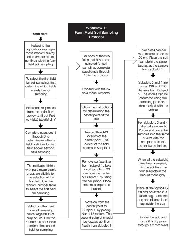
9 Vital Signs Farm Field Soils Protocol 1.0 Note that only fields larger than 10 m x 10 m should be eligible for sampling soils. 4.1 Selection of Major Staple Crop Field for Soil Sampling To select the first field for soil sampling, the enumerator must first determine which fields are to be sampled. This is accomplished by completing Section 13: SOIL DATA ENTRY, Part A, FIELD ELIGIBILITY. This should occur after the agricultural survey, and does not require the participation of any household respondent. The enumerator should reference responses from the agriculture survey to fill out Part A, FIELD ELIGIBILITY. Match each field ID in Section 13 to each field ID from Section 2, FIELD ROSTER (from the agriculture survey). Question 1: Is this field size larger than 100 m2? (or acres) The enumerator determines if the field is larger than 100 m2 (0.025 acres). The enumerator should reference the agriculture survey, Section 2, FIELD ROSTER, Question 3, AREA (ACRES) FARMER'S ESTIMATE. If the field is larger than acres, this question should be marked 1. If not, it should be marked 2, and the enumerator should move on to the NEXT FIELD. Question 2: Was the field cultivated during the current or most recently completed season? The definition for cultivated fields are the same definitions from the agriculture survey, Section 2, FIELD ROSTER, Question 2b1, What was the use of this field during the Long Rainy Season/Major Cropping Season of 2013, and 2c, What is the use of this field during the previous Short Rainy Season/Minor Cropping Season? However, we are now asking about current activity on the field. If, at the time of survey, the farm is in between cultivation seasons (planting through harvesting), please reference the most recently completed season. If the field was CULTIVATED, this question should be marked 1. If not, it should be marked 2, and the enumerator should skip to Question 6. Question 3: Was one of the 3 major crops [insert 3 major crops] grown on this field during the current or most recently completed season? The definitions for major crops are the same definitions from the agriculture survey, Section 2, FIELD ROSTER, question 2b2, What was the main crop cultivated on this field during the Long Rainy Season/Major Cropping Season of 2013 and question 2d1, What was the main crop cultivated on this field during the Short Rainy Season/Minor Cropping Season? However, we are now asking about current 8
10 activity on the field. If, at the time of survey, the farm is in between cultivation seasons (planting through harvesting), please reference the most recently completed season. If the reported crop is one of the major crops, this question should be marked 1. If not, it should be marked 2, and the enumerator should skip to Question 6. Question 4: Is this field a pure stand/monoculture? The enumerator may reference the agriculture survey, Section 4, CROPS BY FIELD, Question 3, Was cultivation intercropped? as an initial guide for the question. If the reported crop is pure stand/ monoculture, this question should be marked 1. If not, it should be marked 2, and the enumerator should skip to Question 6. Question 5: Is this field eligible for testing for first field? The enumerator should refer back to the responses for questions 1-4. Mark 1 in question 5 if both: Question 1, 2, 3 and 4 are marked 1 Question 6: Is this field eligible for testing for second field? Mark 1 in Question 6 if question 1 has been marked 1. Question 7: Is this field selected for testing? Recall that only two fields will be selected for testing. We will randomly select one field that is eligible from Question 5, and one field that is eligible from Question 6. Selection of the first crop field for soil sampling The cultivated selection fields with pure crop major field staple are marked with 1 (Question 5) and are eligible for the selection of the first field (major staple crop). In order to select the field you will need to have a random number table with you (provided by the supervisor, example in Annex I). Reading left to right in the row of the random number table, keep moving to the right until you find a number that matches the field ID number of one of the eligible major staple crop fields (see the example of how to do this below). Cross out this number on the random number table and mark a 1 in Question 7 for the selected field. Note: if there is only one major staple crop field in the household, select that field by default. 9
11 Vital Signs Farm Field Soils Protocol Selection of Second Crop Field for Soil Sampling Second, select another field from all remaining fields, regardless of crop or use. All these fields are marked with 1 (Question 6) and are eligible for selection as the second field. On the same random number table, start again at the left hand side of the random number row, looking for the first number that matches the field ID number of any of the fields. Cross out the entire line on the random number table, and mark a 1 in Question 7 for the selected field. You must not select the same field as the first selection. If there is no pure major staple crop field in the household, select two random fields using the same method as described above. Note: do not use the same number line for multiple households. After randomly selecting the second field, make sure to use the next line in the random number table for new households. 4.3 Example Selection of a Field for Soil Sampling The fields eligible for the first field selection are chosen from those that are larger than 100m2 (Question 1), cultivated (Question 2), and have one or more of the three primary staple crops (Question 3). In this case, let s say that the crops for this location are maize, sorghum, and beans. In this example let s say those crops for this location are maize, sorghum and beans. In this example these are fields with maize (code=11), sorghum (code=13) and beans (code=31) being the major staple crop fields. Next is to see if that crop is planted in monoculture (Question 4). In this case only fields M2 and M5 are eligible to be selected as the first field for soil sampling. Finally, we mark all the eligible first fields for selection (Question 5). Now to randomly select which field, follow the step below (see Section 13.A, FIELD ELIGIBILITY). Use the random number table provided by the supervisor, starting with the first row. To select the major staple crop field, look for the first number in the random number table that matches the field ID number of the eligible fields. In this example, the only eligible fields are M2 and M5. The first number that matches is number 2 this field will be selected for soil sampling. 10
12 Next, we select the second field for testing from all remaining fields, regardless of crop. We mark with 1 all the fields that are eligible for selection of the second field (q6). The field 2 is excluded since it was already selected as a major crop for testing. Looking at the random number table and starting again from left to right, # 7 is the first number that matches the field ID number of one of the fields. Once the first and second fields have been randomly selected, we indicate them in q7. For the two selected fields, write the field ID in Section B. 11
13 12
14 For each of the two fields that has been selected for soil sampling, after arriving at each field, ask the following questions that are practically derived from the soil condition questions for the E-plot sampling. Question 8 - Slope Ask the respondent about the slope of the field. Is it flat, with moderate slope, or with steep slope? Flat (<8%) Moderate slope (8-22%) Steep slope (>22%) Question 9 - Erosion Erosion refers to the loss of topsoil from rain, wind, animals or people. Indicate yes if all or some of the field is suffering from erosion. Question 10 - Erosion Are there visible signs of soil erosion (sheet, rill or gully). Soil erosion: 1 None 2 Slight 3 Moderate 4 Severe Are there any methods to prevent erosion on the field? Question 11 - Erosion What is the main method used to protect the field from erosion and record the code. Question 12 Surface condition score (0-10) Rooted plants Little cover 13
15 Downed wood Stone or gravel Dung Disturbed soil Undisturbed, bare & porous soil Undisturbed, bare but sealed soil Sodic soil Microfloral crust Termite mound In-field measurements For ease of sampling, the soil samples will be taken near the center of the plot. Go the center of the plot. Once the center point of the field has been reached, the location of the sample subplots will be offset randomly. The offset will be determined by 1) direction and 2) distance. 1) Direction Using the random number table, select the first number. Use the direction lookup (Annex II) to match the number to a direction. Note that if an 8 or 9 is selected, the enumerator should skip to the next number to find a direction match. Record the direction in SECTION C SOIL SAMPLE OFFSET. 2) Distance Using the same line in the random number table, select the next number. This will be the number of paces to walk. Record the number of paces in SECTION C SOIL SAMPLE OFFSET. 14
16 From the center of the field, walk to a new point in the field using the direction and number of paces. If a zero is selected, there is no need to walk any paces. If the edge of the field reached and you have not completed your pacing, simply turn around and complete the pacing back towards the center of the field. This point of the field becomes the center plot, and is referred to as subplot 1. If the point turns out such that either of the conditions below hold then offset the point to avoid these conditions. - There are obstacles in that location such as trees, soil conservation structures, a rocky surface - The point is not representative of the main part of the field. For example if a small section of the field, less than 10% appears to be prone to flooding, has slope significantly different from the other part of the field; has shallow or superficial rocky layer such as laterite that is not found in the rest of the field MAKE SURE THE SAMPLING POINT IS AT LEAST 2 M FROM THE EDGE OF THE FIELD. If it is not then move the point directly into the field, perpendicular to the field border to the 2 m limit. Remove surface litter from subplot 1. Take a soil sample to 20 cm from the center of subplot 1 by using the soil probe. Place the soil sample in a bucket. Record any auger depth restrictions encountered for each sub-plot the field (in cm), if present, In the note field Next move on from the center point to subplot #2 by pacing 12 m (or using a measuring tape or a pre-marked chain, This second subplot should be located directly uphill from the center point (if there is no slope then move N from the center to indicate subplot 2). Take a soil sample with the soil probe to 20cm. Place the soil sample in the same bucket as the sample from subplot 1. Subplots 3 and 4 are offset 120 and 240 degrees from subplot 2, respectively. The angles can be estimated using the sampling plate or a disc marked with the angles as indicated in Figure 1. For each of the subplots 3 and 4, take a soil sample to 20 cm and place the sample into the same bucket holding the samples from the other two subplots. 15
17 Note: If one of the sub-plots falls outside of the agricultural field, place the sub-plot 2 m within the farm field boundary. Figure 2. Sample plot layout in agricultural fields, with four subplots (dotted circles). Subplots have a radius of 5.64 m (area = 100 m 2 ), and the distance along the radial arms between the subplot centers is 12.2 m. The whole plot has a radius of m (area = 1000 m 2 ). The angles can be measured using a compass or the sampling plate (Figure 1) can be placed over the center sampling point and marked and used to locate subplots 2, 3 and 4. Note: It is possible that the quadrant is located near the edge or corner of the field refer to figure 3 for instructions on how to deal with this scenario. 16
 so that more subplots are located within the field and buffer.")
18 Figure 3. If the quadrant is close to the edge or corner of the field (1), either one or two of the subplots may be located outside the field AND outside the 2 meter buffer (2). Try first to rotate the orientation of the subplots (3) so that more subplots are located within the field and buffer. If a subplot is still outside of the field, move that subplot inside the 2 meter buffer of the field (4). This subplot will be closer to the center subplot than the other two, and may or may not be inside the quadrant. When all subplots have been sampled, mix the soil from the four subplots in the bucket thoroughly. Take a representative subsample of at least 400g of the soil from the top soil (0-20 cm) bucket and place it in a plastic bag. If there is less than 400g of soil, keep all of the soil. Label the bag. Place a label tag inside the bag. Label the bags with: Site name/code; The full 10 digit HHID (inclusive of country, landscape, E-plot, and household IDs), field number, depth of sample, date of sampling, and FARM FIELD SOILS, as there are multiple types of soil collection. Note that the depth of sample will always be 0-20cm for the farmer fields. 17
19 Air dry the soil, once dried pass the soil through a 2 mm sieve and place approximately 400g soil in a plastic bag with a label on the inside and outside with the label code. Site name/code; HHID, field number, depth of sample, date of sampling Note the depth of sample will always be 0-20cm for the farmer field samples. Prepare the samples for shipping following the country specific instructions. ANNEX I: RANDOM TABLE NUMBER 18
20 ANNEX II: DIRECTION LOOKUP 19
Vital Signs Protocol
 Vital Signs Protocol Maize Yield Measurements and Farm Field Soil Sampling Version 1.1 May 2014 1 ACKNOWLEDMENTS Table of Contents Contents 1 Introduction 1.1 Definitions of Key Technical Terms 1.2 Standard
Living Standards Measurement Study- Integrated Surveys on Agriculture (LSMS-ISA): Ethiopia Socioeconomic Survey (ESS) Crop Cutting Manual
: Ethiopia Socioeconomic Survey (ESS) Crop Cutting Manual") Living Standards Measurement Study- Integrated Surveys on Agriculture (LSMS-ISA): Ethiopia Socioeconomic Survey (ESS) Crop Cutting Manual Central Statistical Agency & The World Bank March 2013 Table of
Living Standards Measurement Study- Integrated Surveys on Agriculture (LSMS-ISA): Ethiopia Socioeconomic Survey (ESS) Crop Cutting Manual Central Statistical Agency & The World Bank March 2013 Table of
This is a protocol that is designed to support the citizen
 Citizen Science Soil Sampling Protocol This is a protocol that is designed to support the citizen scientist in all of us. These soil tests will provide essential information about the short and long-term
USING TITHONIA AS A FERTILISER
 USING TITHONIA AS A FERTILISER Compiled by RESCAP WHAT IS TITHONIA? Tithonia was initially introduced from Central America as an ornamental. It is now a common flower that grows along roads and on waste
Nitrogen Dynamics Feeding the Crops that Feed Us
 Nitrogen Dynamics Feeding the Crops that Feed Us Overview All plants require nitrogen in relatively large amounts and nitrogen is the most commonly limiting nutrient in agriculture. Consequences of insufficient
APPENDIX F. Soil Sampling Programs
 166 Soil Sampling Programs Soil sampling for laboratory analysis is the only way to determine the levels of plant nutrients in a field and obtain fertilizer recommendations for that field It is also required
2018 CORN/SOYBEAN OBJECTIVE YIELD SURVEY
 2018 CORN/SOYBEAN OBJECTIVE YIELD SURVEY SURVEY PURPOSE The Corn and Soybean Objective Yield Surveys are two objective yield surveys conducted in Ohio and Indiana. The purpose of both the Corn and Soybean
2017 Cotton Objective Yield
 2017 Cotton Objective Yield School Overview Welcome and Introductions Purpose and Sample Kit Envelopes Form A Initial Interview Locating and Laying Out the Unit School Overview Form B Counts/ MOST/CAPI
Alley Cropping. An Introduction to incorporating long-term tree crops and short-term farm crops
 Alley Cropping An Introduction to incorporating long-term tree crops and short-term farm crops Presentation Objectives Define alley cropping Describe the general benefits and how an alley cropping system
3.3.3 Landscape-Directed Soil Sampling
 12 3 Soil Sampling and Analysis 3.1 Principles of Soil Sampling Soil sampling and analysis is the only way to determine the available nutrient status of a field and to receive field-specific fertilizer
Winter Wheat Objective Yield Training Workshop. April 26, 2018 North Platte, Nebraska
 Winter Wheat Objective Yield Training Workshop April 26, 2018 North Platte, Nebraska 1 Welcome and Introductions Name Town and County Years as a NASDA enumerator Experience with WOY? 2 Workshop Overview
Agriculture and Society: Part II. PA E & E Standards 4.4
 Agriculture and Society: Part II PA E & E Standards 4.4 Let s get Dirty! 1. All agriculture ultimately depends on the soil. What is soil? Soil is the upper layer of the land surface that contains pieces
Winter Cover Crops in New York State: 2014 Double Crop N Rate Study Set-up Protocol
 1 P a g e Winter Cover Crops in New York State: 2014 Double Crop N Rate Study Set-up Protocol (Revised March 5, 2014) Contact Person: Greg Godwin (Phone: 607-279-4627) Nutrient Management Spear Program
AP Environmental Science II. Unit 2-6: Soil, Agriculture, and Land Management
 NOTE/STUDY GUIDE: Unit 2-6, Soil, Agriculture and Land Management AP Environmental Science II, Mr. Doc Miller, M.Ed. North Central High School Name: ID#: NORTH CENTRAL HIGH SCHOOL NOTE & STUDY GUIDE AP
Very slight to negligible limitations no special land management practices required.
 Land Capability Classes Land and Soil Capability Class 1 Class 1 Definition Very slight to negligible limitations no special land management practices required. On-site impact of land management practices
Overview. Learning Objectives: This module provides step-by-step instructions in how to do the Bulk Density Protocol.
 Overview This module provides step-by-step instructions in how to do the Bulk Density Protocol. Learning Objectives: After completing this module, you will be able to: Explain why bulk density is worth
14 FARMING PRACTICES Land preparation. - To control the growth of weeds; - To shape the seedbed (into ridges, beds, or mounds).
.") 14 FARMING PRACTICES An enumerator working in farm surveys needs a basic understanding of the agricultural operations done by the farmers during the crop season. It is on these subjects that he will be
14 FARMING PRACTICES An enumerator working in farm surveys needs a basic understanding of the agricultural operations done by the farmers during the crop season. It is on these subjects that he will be
Nebraska Soil Science Curriculum
 Nebraska Soil Science Curriculum Soil Quality Measurement Approximately 180 minutes ***Content and lab derived from the USDA-NRCS Guides for Educators. Please see the Guides for additional helpful pictures
Land Application of Manure
 University of Nebraska Cooperative Extension EC 98-758-S WORKSHEET 11 Nebraska s Farm Assessment System for Assessing the Risk of Water Contamination Why should I be concerned? Stewardship of soil and
Practical guide for Land Degradation Monitoring
 Practical guide for Land Degradation Monitoring Technical Report No. L-20 December 2010 1 Somalia Water and Land Information Management Ngecha Road, Lake View. P.O Box 30470-00100, Nairobi, Kenya. Tel
Soil Health Field Assessment Worksheet
 Soil Health Field Assessment Worksheet Location: Field: Test: of Name: Assessor: Date: Soil Map Unit: Soil Moisture: Topsoil Texture: Indicator Avg. Rating Potential Practices Residue cover (Plant residue
Stubble Mulch Judging : Extension Circular
 University of Nebraska - Lincoln igitalcommons@university of Nebraska - Lincoln Nebraska 4-H Clubs: Historical Materials and Publications 4-H Youth evelopment 4-1958 Stubble Mulch Judging : Extension Circular
Appendix D. Erosion Management Sub- Plan
 Appendix D Erosion Management Sub- Plan DRENNAN SOLAR ENERGY FACILITY EROSION MANAGEMENT PLAN PRODUCED FOR ERM ON BEHALF OF SOLAIREDIRECT BY Simon.Todd@3foxes.co.za JUNE 2013 PURPOSE The purpose of the
Edible Hemp Foliar Sampling Project 2018 Judson Reid and Lindsey Pashow; Harvest NY Cornell Cooperative Extension
 Edible Hemp Foliar Sampling Project 2018 Judson Reid and Lindsey Pashow; Harvest NY Cornell Cooperative Extension Hemp, a multi-use crop that has been cultivated for centuries, is increasingly cultivated
Digging Deeper Soil in Atlantic Canada
 DESCRIPTION Soil erosion is one of the most important environmental issue in Atlantic Canada. Students in this region need to be familiar with soil conservation practices. & & & OBECTIVES to develop an
3.3 Soil Cultivation and Tillage
 3.3 Soil Cultivation and Tillage Introduction Soil cultivation includes all mechanical measures to loosen, turn or mix the soil, such as ploughing, tilling, digging, hoeing, harrowing etc. Careful soil
Soil Quality How can we improve soil quality?
 Activitydevelop Soil Quality How can we improve soil quality? Overview Students explore the conditions that make high-quality soils. Using data from field research and interactive computational models,
Chapter 9: Soil and Agriculture
 Chapter 9: Soil and Agriculture Terms to know: Agriculture No-till farming Cropland Rangeland Soil Monoculture Polyculture Green Revolution Chemical weathering Biological weathering Physical weathering
A Guide to Collecting Soil Samples for Farms and Gardens
 A Guide to Collecting Soil Samples for Farms and Gardens M. Fery and E. Murphy Without a soil analysis, it s nearly impossible to determine what a soil needs in order to be productive. Laboratory soil
Marla Riekman, MAFRD Adam Hayes, OMAFRA David Lobb, U of M Mario Tenuta, U of M
 Marla Riekman, MAFRD Adam Hayes, OMAFRA David Lobb, U of M Mario Tenuta, U of M a) Earthworms, microbes b) Good soil structure c) High yielding d) Black soil high in Organic Matter e) Earthy smell Defined
Soil Fertility, Weed Biomass And Cowpea (Vigna Unguiculata (L.) Walp ) Performance Under Different Cowpea Based Intercropping Systems
 Walp ) Performance Under Different Cowpea Based Intercropping Systems") Soil Fertility, Weed Biomass And Cowpea (Vigna Unguiculata (L.) Walp ) Performance Under Different Cowpea Based Intercropping Systems B. Osundare ABSTRACT: Although, in Southwestern Nigeria, many aspects
Soil Fertility, Weed Biomass And Cowpea (Vigna Unguiculata (L.) Walp ) Performance Under Different Cowpea Based Intercropping Systems B. Osundare ABSTRACT: Although, in Southwestern Nigeria, many aspects
Progress report on the Agronomy Component By Wezi Mhango and Cheryl Palm April 30, 2015
 Progress report on the Agronomy Component By Wezi Mhango and Cheryl Palm April 30, 2015 1. Soil sampling and analysis Soil samples were collected at 0-20cm soil depth from 411 farmers plots and 19 demonstration
Wetland Vegetation Monitoring Protocol
 Wetland Vegetation Monitoring Protocol Terrestrial Long-term Fixed Plot Monitoring Program Regional Watershed Monitoring and Reporting November 2011 Report prepared by: Natasha Gonsalves, Environmental
Methodological experiment on measuring cassava production, productivity, and variety identification in Malawi
 Methodological experiment on measuring cassava production, productivity, and variety identification in Malawi T. Kilic The World Bank, Living Standards Measurement Study Team (LSMS), Development Data Group
APPENDIX II Soil Testing Plan
 APPENDIX II Soil Testing Plan After rough backfilling and grading, Alcoa will place permanent markers on 500-foot centers in the regraded area to delineate a 5.7-acre grid system for monitoring postmine
EOC BIOLOGY 2010 OPERATIONAL PERFORMANCE TASK FUELING CHANGE RELEASED AUGUST 30, 2010
 EOC BIOLOGY 2010 OPERATIONAL PERFORMANCE TASK FUELING CHANGE RELEASED AUGUST 30, 2010 Part 2 Fueling Change CropCorp is a new corporation with the mission of developing new biofuels. 6 You have been hired
Poultry production is the number one agricultural
 The Value of Poultry Litter in South Georgia Claudia S. Dunkley, Extension Poultry Scientist, Department of Poultry Science Dan L. Cunningham, Extension Poultry Scientist, Department of Poultry Science
Soil Sampling Guidelines
 Agronomy ag.purdue.edu/agry AY-368-W Author: Jason P. Ackerson, Assistant Professor of Agronomy Soil testing is an integral part of a soil fertility management program. Effective soil testing provides
Selecting a Study Site
 Selecting a Study Site Vocabulary hectare (ha): A metric unit of area. 1 ha = 10,000 m 2 = 2.47 acres. 1 acre = 0.40 ha. meter (m): A metric unit of length. 1 m = 3.28 ft. 1 ft = 0.3048 m. 1 m x 1 m =
Bulk Density Protocol
 Bulk Density Protocol Purpose To measure the soil bulk density of each horizon in your soil profile. Overview Students obtain a soil sample in the field using a container with a measured volume. The soil
Efficient Fertilizer Use Soil Sampling for High Yield Agriculture: by Dr. Harold Reetz
 SECTION CONTENTS: Soil Sampling Sampling Procedures Sampling Patterns Options Auxiliary Data Layers Sampling Under Different Tillage Systems Identifying Missed Opportunities Through Intensive Sampling
Rice Nitrogen Management- Rates and Timing of Urea Fertilizer Gene Stevens and David Dunn University of Missouri-Delta Research Center
 Rice Nitrogen Management- Rates and Timing of Urea Fertilizer Gene Stevens and David Dunn University of Missouri-Delta Research Center Managing nitrogen fertilization in rice fields can be challenging
SUMMARY SPECIFICATIONS. Product Specifications and Application Guidelines for Compost Mulches for Orchard Production in NSW
 SUMMARY SPECIFICATIONS Product Specifications and Application Guidelines for Compost Mulches for Orchard Production in NSW Recycled Organics Unit Building G2 The University of New South Wales UNSW Sydney
DOMINANT CRITICAL AREA BASIC PLANNING CONCEPTS FOR RUSLE2
 NRCS, WI April 2005 DOMINANT CRITICAL AREA BASIC PLANNING CONCEPTS FOR RUSLE2 NRCS requires the use of the Revised Universal Soil Loss Equation, Version 2 (RUSLE2) for conservation planning done to address
Appleton Wastewater Treatment Plant Biosolids Management Program
 CITY OF APPLETON Appleton Wastewater Treatment AWWTP Biosolids Program Objectives The City of Appleton, Wastewater Treatment Plant (AWWTP) produces approximately 20,000 wet tons of biosolids per year.
Soil and farm practices data concerning the case study Svratka were collected according to questionnaire 1 by the expert on soil protection.
 Soil and farm practices data concerning the case study Svratka were collected according to questionnaire 1 by the expert on soil protection. Farmers in the case study region were interviewed according
Materials: a piece of sandpaper, a piece of wood to sandpaper, a stone to sandpaper
 RM4.3 Curriculum: Rocks, Minerals, and Erosion (grade 4) Overview: Students will learn what we can do to prevent unwanted wind erosion. They will be able to write an answer to the question: How does the
Principles of nutrient management
 Principles of nutrient management A - Soil balance Tasmanian Office: 1/9 Arnold Street, Penguin PO Box 396 Penguin, Tasmania 7316 T (03) 6437 2264 F (03) 6437 2271 E rm@rmcg.com.au W www.rmcg.com.au ABN
INVESTIGATION: Flour vs. Bread: How Soil Aggregate Structure Influences Water Flows. Time: minutes, depending on the amount of discussion.
 INVESTIGATION: Flour vs. Bread: How Soil Aggregate Structure Influences Water Flows Time: 15-60 minutes, depending on the amount of discussion. Grade Level: appropriate for any age. Summary: If I only
Survey Expert to provide assistance for the Randomized rural household survey Scope of Work (SOW)
") AgResults Kenya On-Farm Storage Pilot Survey Expert to provide assistance for the Randomized rural household survey Scope of Work (SOW) 1. Consultant Name TBD 2. Period of Performance TBD 3. Level of Effort
AgResults Kenya On-Farm Storage Pilot Survey Expert to provide assistance for the Randomized rural household survey Scope of Work (SOW) 1. Consultant Name TBD 2. Period of Performance TBD 3. Level of Effort
Common Construction-Site BMPs Quick Reference Guide
 Common Construction-Site BMPs Quick Reference Guide Installation and Inspection Requirements For more information visit the Town of Truckee Clean Water Program Website: http://www.townoftruckee.com/engineering/clean-water-program
PART 5 PAGE Trial Year 2018 Total number of pages in this section at initial pagination:
 A. DIRECTIONS TO TEST SITE INSTRUCTIONS: Indicate the name and location (street, town, state) of the test site (e.g. Banana Research Center, Rt. 3, Nenana, AK), the county (e.g. Denali), and provide directions
African Organic Agriculture Manual Booklet Series No. 3 Soil and water conservation HOW DO I PROTECT THE SOIL NUTRIENTS AND WATER FROM LOSS?
 African Organic Agriculture Manual Booklet Series No. 3 Soil and water conservation HOW DO I PROTECT THE SOIL NUTRIENTS AND WATER FROM LOSS? What do I need to know about soil and water? Plants and animals
Recommended Resources: The following resources may be useful in teaching this lesson:
 Unit E: Basic Principles of Soil Science Lesson 7: Understanding Soil Erosion and Management Practices Student Learning Objectives: Instruction in this lesson should result in students achieving the following
Ethiopia - Rural Socioeconomic Survey
 Microdata Library - Rural Socioeconomic Survey 2011-2012 Central Statistical Agency - Ministry of Finance and Economic Development, Living Standards Measurement Study Team - The World Bank Report generated
2018 ARMS Phase 2 Home Study Quiz
 2018 ARMS Phase 2 Home Study Quiz Enumerator Name: The following quiz relates directly to information needed to complete the 2018 ARMS Phase 2 PPCR/PPR questionnaire (s). Mark the box next to all correct
Chapter 9 Soil and Agriculture Guided Notes
 Chapter 9 Soil and Agriculture Guided Notes This lecture will help you understand: The relationship between and Major agricultural The fundamentals Causes and of soil erosion and Principles of soil No-till
Comparing Farmer Perceived Soil Quality And Measured Soil Quality In Tanzania: Do They Align?! Leigh Anderson! Mary Kay Gugerty! Allison Kelly!
 Comparing Farmer Perceived Soil Quality And Measured Soil Quality In Tanzania: Do They Align?! Leigh Anderson! Mary Kay Gugerty! Allison Kelly!! Outline! Motivation: Agricultural Yield Gaps! Theory: Identifying
ATTACHMENT 4: PROCEDURE FOR SOIL FERTILITY EXPERIMENT ON MICRO-DOSING
 ATTACHENT 4: PROCEDURE FOR SOIL FERTILITY EXPERIENT ON ICRO-DOSING DETERINING OPTIAL IXTURE OF ORGANIC AND INORGANIC FERTILIZERS FOR SOIL FERTILITY AND PLANT RESPONSE BACKGROUND Context: In south-central
Ethiopia - Socioeconomic Survey
 Microdata Library Ethiopia - Socioeconomic Survey 2013-2014 Central Statistics Agency of Ethiopia (CSA) - Ministry of Finance and Economic Development, Living Standards Measurement Study Integrated Surveys
Sustainable Intensification and Diversification of Maize-based Farming Systems in Malawi
 Sustainable Intensification and Diversification of Maize-based Farming Systems in Malawi Dan TerAvest and John P. Reganold Produced by Published by International Wheat and Maize Improvement Centre Washington
Start by put the words sustainable and conventional methods on the flip chart. Brainstorm ideas then synthesize those that seem to fit the best.
 TITLE: Introduction to Sustainable Agriculture and Food Systems OBJECTIVES: To introduce the principles of sustainable agriculture and how they are used on the farm. To introduce the terms industrial/global
Activity 1: Flood Storage
 Activity 1: Flood Storage Overview Background Students will observe how different soil components peat, sand, gravel, and potting soil vary in their capacity to absorb and hold water. They will observe
The soil is a very. The soil can. The manure. Soil Characteristics. effective manure treatment system if manures are applied at the proper rate.
 The soil is a very effective manure treatment system if manures are applied at the proper rate. The soil can filter pollutants and prevent them from reaching groundwater. The manure application rate should
IMPROVING PASTURES BY RENOVATION Ed Ballard,Retired Animal Systems Educator University of Illinois Extension
 IMPROVING PASTURES BY RENOVATION Ed Ballard,Retired Animal Systems Educator University of Illinois Extension In Illinois, pastures are generally relegated to land that is too steep and rocky for row crops.
The Area Screening Questionnaire MAY 22, 2018
 The Area Screening Questionnaire GREAT LAKES REGION MID-YEAR TRAINING MAY 22, 2018 Purpose and Importance Farm Definition Any establishment from which $1,000 or more of agricultural products were sold
Appendix 13A Calibrating Manure Spreaders
 651.1350 Appendix 13A Calibrating Manure Spreaders (210-vi-AWMFH, May 1996) 13A 9 13A 10 (210-vi-AWMFH, May 1996) Appendix 13A Calibrating Manure Agricultural Spreading Waste Management The use of animal
Best Practices for Building High-Performance Resource Roads. Road Drainage. Developed by: The Roads and Infrastructure Group
 Best Practices for Building High-Performance Resource Roads Road Drainage Developed by: The Roads and Infrastructure Group THIS GUIDE IS INTENDED FOR EQUIPMENT OPERATORS CONSTRUCTION CONTRACTORS FIELD
Key Components of CNMP for Poultry Producers
 GUIDELINES AND PROCEDURES FOR THE IMPLEMENTATION OF POULTRY NUTRIENT MANAGEMENT PLANS The University of Georgia Department of Poultry Science Department of Crop and Soil Sciences Department of Biological
2. PLANNING AND MAKING A SOIL SURVEY
 Sample all soil horizons over 10 cm in thickness; all samples should represent natural soil horizons or 2.0 The purpose of the soil survey 2. PLANNING AND MAKING A SOIL SURVEY The purpose of making a soil
A soil health analysis of the Nathan Stecklein home farm. Nicole Stecklein
 A soil health analysis of the Nathan Stecklein home farm Nicole Stecklein Historical yield data for Nathan s Home Farm Field Year Crop Yield (bu/ac) North 2008 Corn 177 2009 Corn 214 2010 Corn 177 2011
1 Egyptian J. Desert Res., 65, No. 1, 1-10 (2015)
") 1 RUNOFF MANAGEMENT TECHNOLOGY FOR INTEGRATED DRY LAND AGRICULTURE IN JATINANGOR RESEARCH CENTER WEST JAVA, INDONESIA Nurpilihan Bafdal *, Sophia Dwiratna and Dwi R. Kendarto Soil and Water Engineering
1 RUNOFF MANAGEMENT TECHNOLOGY FOR INTEGRATED DRY LAND AGRICULTURE IN JATINANGOR RESEARCH CENTER WEST JAVA, INDONESIA Nurpilihan Bafdal *, Sophia Dwiratna and Dwi R. Kendarto Soil and Water Engineering
Operating, Calibrating, and Maintaining Irrigation Systems
 Lesson A7 4 Operating, Calibrating, and Maintaining Irrigation Systems Unit A. Mechanical Systems and Technology Problem Area 7. Agricultural Equipment Systems Lesson 4. Operating, Calibrating, and Maintaining
INJECTING LIQUID HOG MANURE FOR IMPROVING CROP YIELDS
 INJECTING LIQUID HOG MANURE FOR IMPROVING CROP YIELDS IMPROVING SOIL QUALITY BY SOIL INJECTING LIQUID HOG MANURE AND ELEMENTAL SULPHUR Mike Grevers and Jeff Schoenau SUMMARY The application of hog manure
FERTILITY RECOMMENDATIONS
 FERTILITY RECOMMENDATIONS Soil fertility is one of the primary yield building components of small grain management. A properly managed fertility program, including recommended fertilization and liming
A review of methods for estimating yield and production impacts
 A review of methods for estimating yield and production impacts Andrew Dorward and Ephraim Chirwa December 2010 Summary This paper documents methodological lessons from experience in estimating yield and
Soil conditions and tree growth on rehabilitated and degraded sites: stewardship of British Columbia s forest soils.
 Soil conditions and tree growth on rehabilitated and degraded sites: stewardship of British Columbia s forest soils. Annual technical report- executive summary Project Y062250 Project Start date: April
Comparing Strip Trials of Chicken Litter, Compost, Hog Manure, and Wet Cattle Manure on Soil Fertility
 Digital Collections @ Dordt Student Work 5-4-2018 Comparing Strip Trials of Chicken Litter, Compost, Hog Manure, and Wet Cattle Manure on Soil Fertility Tanner Douma Dordt College Emily Hummel Dordt College
2013 Double Crop N Rate Study
 Nutrient Management Spear Program 2013 Double Crop N Rate Study Setup Protocol Shona Ort Introduction Double Cropping A method of increasing crop production by growing more than one crop in a season. Most
Methods: Record the date and time in the data book.
 Chemical Station Materials & Methods Materials: 3 Tall Plastic Vials with Caps 1 Small Glass Vial with Cap 1 Nitrate Tablet #1 1 ph Tablet 1 Nitrate Tablet #2 1 Phosphate Tablet 2 Dissolved Oxygen (DO)
Survey Statistician to provide assistance for the Randomized rural household survey Scope of Work (SOW)
") AgResults Kenya On-Farm Storage Pilot Survey Statistician to provide assistance for the Randomized rural household survey Scope of Work (SOW) 1. Consultant Name: TBD 2. Period of Performance: TBD 3. Level
AgResults Kenya On-Farm Storage Pilot Survey Statistician to provide assistance for the Randomized rural household survey Scope of Work (SOW) 1. Consultant Name: TBD 2. Period of Performance: TBD 3. Level
Web Soil Survey National Cooperative Soil Survey
 99 52' 37'' W Yields of Irrigated Crops (Component): Cotton lint (Lbs) Haskell County, Texas 99 51' 40'' W 33 21' 4'' N 418500 418600 418700 418800 418900 419000 419100 419200 419300 419400 419500 419600
SOIL CULTIVATION AND CONSERVATION AGRICULTURE
 SOIL CULTIVATION AND CONSERVATION AGRICULTURE Soil cultivation Soil is cultivated to combat weeds, pests and diseases, to incorporate crop residues, and chemicals and to create a favourable seedbed for
Narration: In this presentation you will learn about the methods available for measuring and
 1 Narration: In this presentation you will learn about the methods available for measuring and monitoring forest carbon pools in the field. You will learn about indirect methods for aboveground tree biomass,
2017 BMR Sorghum vs Corn Silage for Yield and Quality Harvest Protocol
 2017 BMR Sorghum vs Corn Silage for Yield and Quality Harvest Protocol Contact: Sarah Lyons (Phone: 828-290-3584) Nutrient Management Spear Program http://nmsp.cals.cornell.edu/nyonfarmresearchpartnership/foragesorghum.html
extension.missouri.edu Archive version -- See Using Your Soil Test Results
 University of Missouri Extension G9111, Reviewed October 1, 1993 Editor's note: Use the XPLOR order form to purchase the printed version of this publication, which includes a sample soil test report. Using
Recommended Soil Sampling Methods for South Dakota
 South Dakota State University Open PRAIRIE: Open Public Research Access Institutional Repository and Information Exchange Fact Sheets SDSU Extension 5-1-2006 Recommended Soil Sampling Methods for South
Erosion, Erosion, Everywhere
 Erosion, Erosion, Everywhere Main Objectives 1.Capable of describing the magnitude of accelerated soil erosion in the past and at the present. 2.Comprehend the mechanics and the factors influencing water
HUMANITY AGAINST HUNGER
 M A S T E R 4.1 HUMANITY AGAINST HUNGER You have been selected to join Humanity AGAINST Hunger, an international effort dedicated to fighting hunger around the world. Globally, it is estimated that 842
Soil Quality Assessment
 Soil Quality Assessment This is a very new concept, therefore it is rapidly changing Remember that a soils quality is defined by its ability to function Therefore the first question that must be answered
Improved fallows for African farmers
 Improved fallows for African farmers Notes to broadcaster The following article is adapted from parts of 'Improved fallows for western Kenya: An extension guideline', a 56-page document published by the
Impacts of crop management strategies on nutrient stratification and soil test interpretation
 Impacts of crop management strategies on nutrient stratification and soil test interpretation Rochelle Wheaton, Hart Field-Site Group Sean Mason, University of Adelaide and Agronomy Solutions Key Findings
Interpretations and Management of Soil
 Interpretations and Management of Soil Lesson 12: Interpretations and Management of Soil The first steps in evaluating soils involve learning how to identify horizons and site characteristics, and how
CALIFORNIA CERTIFIED CROP ADVISER PERFORMANCE OBJECTIVES
 CALIFORNIA CERTIFIED CROP ADVISER PERFORMANCE OBJECTIVES California Certified Crop Advisers 1143 N. Market Blvd., Ste. 7 Sacramento, CA 95834 Telephone: (916) 928-1625 Facsimile: (916) 928-0705 Website:
Equipment. Methods. 6. Pre-treatment monitoring will take place during the growing season.
 Vegetation and Fuel Monitoring Protocols for the Long Island Pine Barrens Fire Management Demonstration Site Project Adapted from the UMass Project Managing Fuels in Northeastern Barrens Plot Selection,
Pumpkin Grown on Leaf Mulch Produces Large Attractive Fruit and Builds Soil Quality
 Pumpkin Grown on Leaf Mulch Produces Large Attractive Fruit and Builds Soil Quality J. Heckman and A. Wyenandt Mid-Atlantic Pumpkin School January 24, 2007 2 Passes = 6 inch Mulch Layer (20 dry tons/acre)
4.2 Associating Crops and Crop Rotation
 4.2 Associating Crops and Crop Rotation Introduction In many traditional agricultural systems a diversity of crops in time or space can be found. There are different reasons, why farmers do rotate or associate
Module 3: Sampling Methods for Crop-Cutting Surveys
 Sub Regional Training Course on Sampling Methods for Producing Core Data Items for Agricultural and Rural Statistics Module 3: Sampling Methods for Crop-Cutting Surveys 13 17 August 2018, Suva, Fiji 20
tfirst Monitoring alternative fertilisers demonstration
 tfirst Monitoring alternative fertilisers demonstration Moorooduc Plains 2017 Monitoring alternative fertilisers on the Moorooduc Plains Introduction The aim of this demonstration was to provide some information
GROUND WATER RECHARGE
 ST 3.4 GROUND WATER RECHARGE Version : April 2009 Published by : Foundation Connect International Autors : Henk Holtslag & John de Wolf Disclaimer This manual (ST 3.4) is part of the main manual, named