LADA Group Sri Lanka. Natural Resources Management Centre Department of Agriculture Sri Lanka
|
|
|
- Juliana Bishop
- 5 years ago
- Views:
Transcription


1 LADA Group Sri Lanka Natural Resources Management Centre Department of Agriculture Sri Lanka

2 Lies in the between longitudes E latitudes N Land Area 64,453.6 Km 2 Inland Water 1,156.2 Km 2 Maximum length 435 Km maximum width 225 Km Extensive faulting and erosion over time have produced a wide range of topographic features


3 CLIMATE Annual rainfall varies between 900 mm to over 5500 millimeters Average Rainfall Dry zone < 1,750 mm Intermediate zone 1,750-2,500 mm Wet zone > 2,500 mm Very high spatial variability of rainfall 46 Agro-ecological regions

4 Agro ecological map of Sri Lanka

5 Soils of Sri Lanka Nine out of the ten major soil orders based on the USDA soil taxonomic system are distributed through out the country in a mosaic pattern (Panabokke, 1978)


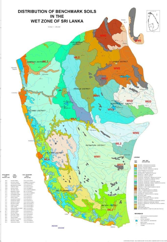
6 Series level soil map of Sri Lanka soil series level spatial distribution in wet, intermediate and dry zone respectively
7 Land degradation processes in Sri Lanka 1. Soil erosion: loss of surface soil by water and wind. The productivity of 50 % of land in the agricultural sector is significantly affected due to soil erosion 2. Fertility decline: Net decrease in available nutrients and organic matter in the soil. The productivity of 30 % of land in the agricultural sector is significantly affected due to declining soil fertility. 3. Dystrification: Lowering of soil ph by increasing acidic compounds in soil. The productivity of agricultural lands particularly cultivated with tea, potato and vegetable in the up country wet zone are significantly affected due to acceleration of the dystrification process.
8 Land degradation processes in Sri Lanka. 4. Sealing and crusting: Clogging of pores in soil surface with fine soil material and development of a thin impermeable layer. It has been very common in lands exploited for seasonal agriculture in the Alfisols region in Sri Lanka. 5. Compaction: Deterioration of soil structure and formation of a dense layer by trampling or frequent use of machinery. It has been very common in rice lands on Alfisols where shallow farm implements such as rotary tillers are frequently used for land preparation. In this situation, a compacted soil horizon has been developed over the plow pan in rice lands causing a reduction in the effective depth of Ap horizon. 6. Salinization/alkalization: Net increase in salt content/sodium content of soil leading to significant decline in crop productivity. The productivity of low lands particularly in the low country dry zone are affected due to acceleration of salinization/alkalization processes
9 Land degradation processes in Sri Lanka.. 7. Water logging: Net increase in soil voids filled with water and it causes a significant decline in crop productivity. This situation is created temporally or permanently in soil due to increasing up of ground water table or lowering down of water infiltration as a result of human activities. It has been very common in lowland. Fortunately, as rice is grown well under waterlogged conditions, such lands are productively used in agriculture in Sri Lanka. 8. Subsidence: Lowering of soil surface particularly in organic soil. It has been reported from lands filled for non agricultural purposes in the Histosol region of Sri Lanka. 9. Aridification: A net decrease in average soil moisture content due to human activities. It has been reported from uplands particularly in the dry zone where greater fraction of precipitation goes as runoff. Therefore, it causes a decline in soil profile storage. 10. Pollution: Addition of materials to soil which causes toxic effects in soil. It has been reported in areas where industrial and urban waste is disposed over the land.

10 1.Assess Land Degradation at national and sub-national levels 2.Identify the Intensity and Trends of Land Degradation 3.Identify the priority areas / high risk areas 4.Identify the areas where the degradation has been slowed or reversed through conducive policies and actions 5.Build national and regional assessment capacities 6.Building a national / regional database of degradation status in aid of monitoring status / trends
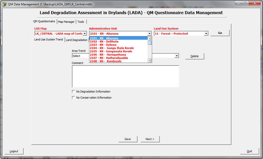
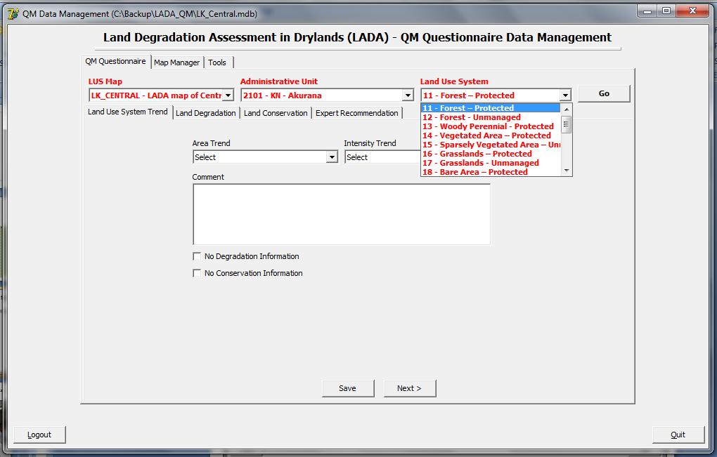
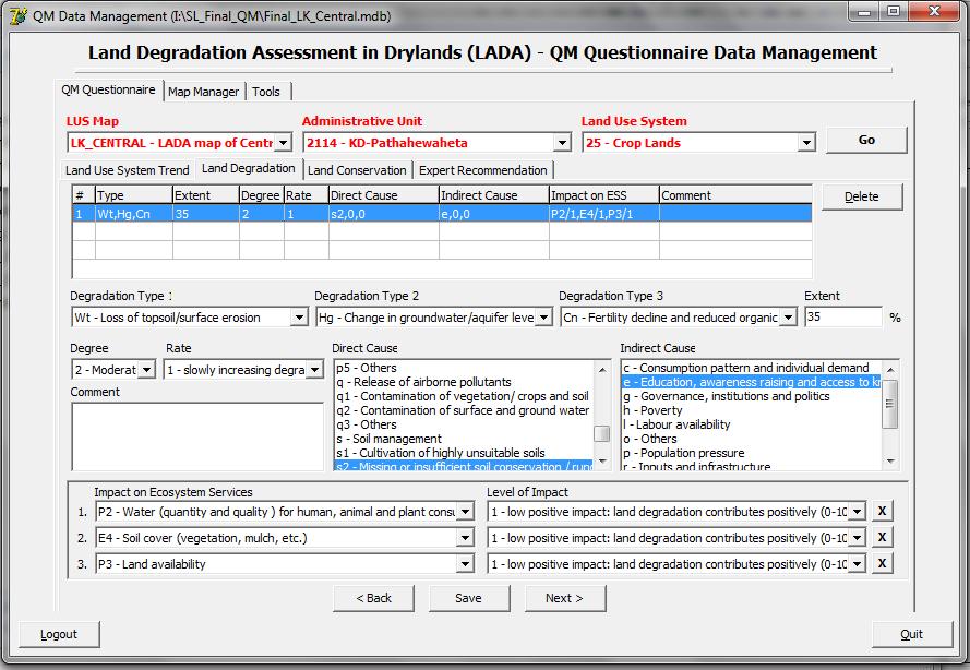
11 Development of Administration unit Development of LUS maps Combining LUS and ADMIN Preparation of QM software for data processing Collection of degradation related data Entering data in LADA-QM Degradation map development
12 Data Description Source of data 1 Landuse data Extracted from digital map layers of land use, water and built-up area from 1:50000 scale topographic map sheets Survey department of Sri Lanka 2 Admin boundary map Admin boundaries for province, District, DSD and GN division has been used for LADA QM mapping unit development Digital Admin map available at NRMC was used 3 Forest and wildlife reserve The digital map of forest and reservation areas of has been used Department of Forest 4 Elevation and Slope Slope map was developed using GIS analysis with 30m Digital Elevation Model 30m data downloaded from ASTGTM website
13 Data Description Source of data 5 Paddy area map Paddy land map updated by Forecasting project of NRMC for Ampara, Polonnaruwa and Batticaloa Natural Resources Management Centre, DOA. has been used 6 Climate data Rainfall and other climate data Met database, 7 Agro-ecological map Digital map has been Used for LUS boundary adjustments NRMC Natural Resources Management Centre, DOA. 8 Expert knowledge on land degradation Expert knowledge and local experiences were included in the LADA-QM approach Data gathered through guided discussions held in national workshops and informal small group meetings.
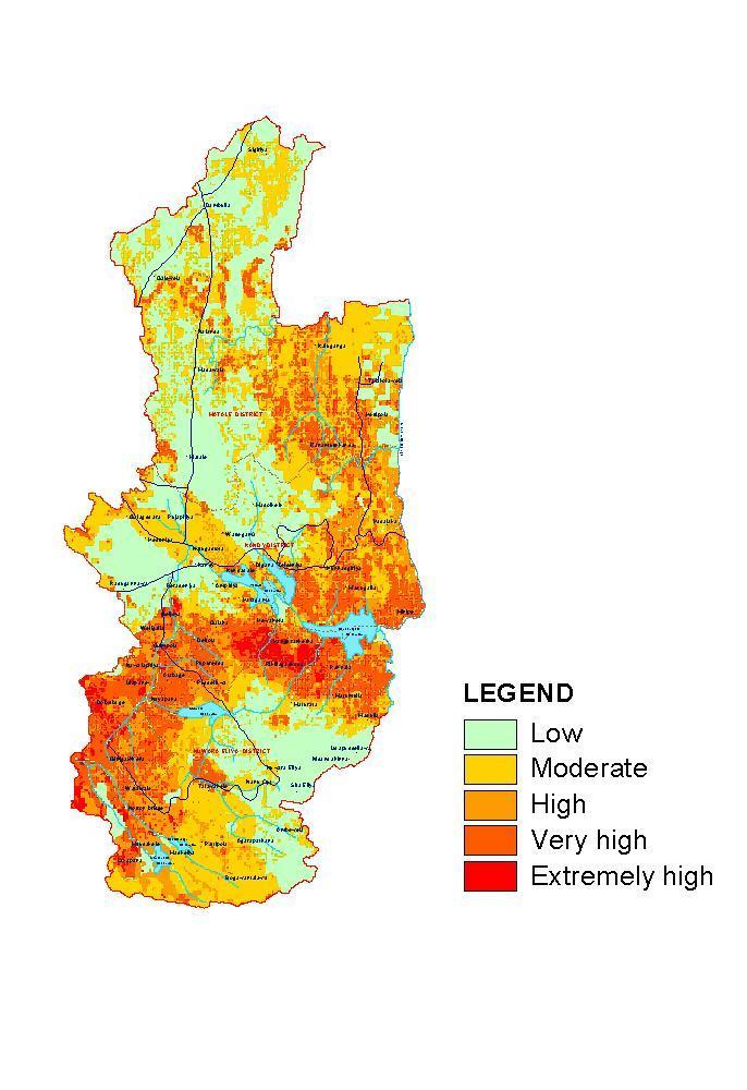
14 Data Description Source of data 9 Degradation related information Information on prominent degradation types and affected localities were also used during assessment Information was extracted from available literature 10 Erosion hazard maps Erosion hazard map of central highlands covering central and uva province was also used as a guide map for assess accuracy levels of LADA maps Natural Resources Management Centre, DOA.

15 9 Provinces
16 9 Provinces 25 Districts

17 District Codes

18 9 Provinces 25 Districts 331 DS Divisions


19 9 Provinces 25 Districts 331 DS Divisions 14,022 GN Divisions
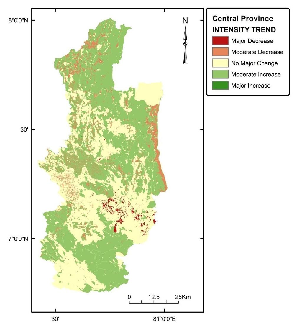
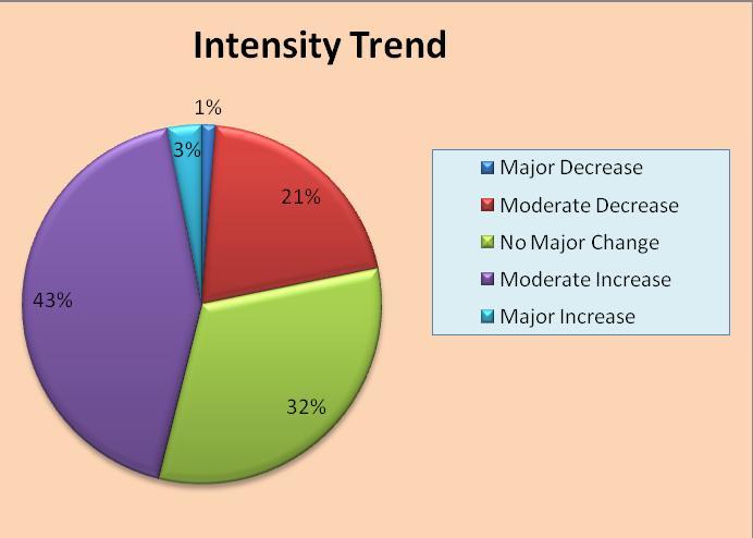
20 Central Province Wide range of land use types Wide range of land degradation levels Hilly area Wide range of climatic zones Feeding area for most of the rivers and streams Most sensitive area

21 Implementation area of the Soil Conservation Act Extraordinary Gazette No 1550 / 9 : 2008 May 22 Legend Low Moderate High Very high Extraordinary Gazette No 1550 / 9 : 2008 May 22 Soil conservation boundary District boundary Divisional secretariat boundary
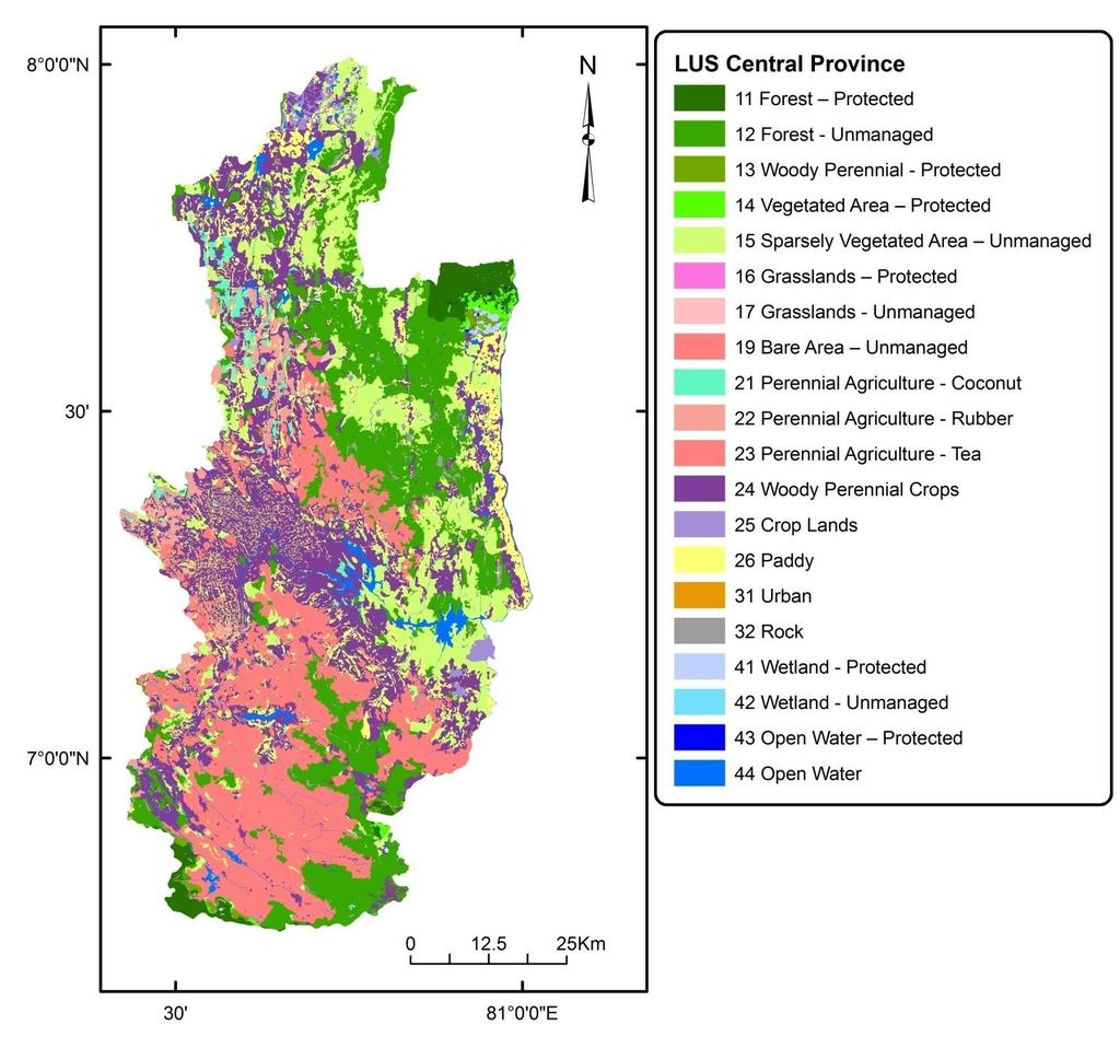
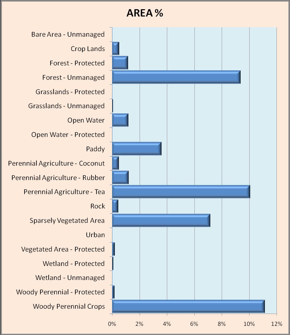
22 Central Province
23 Central Province 36 DS Divisions

24 9 Provinces 25 Districts 331 DS Divisions Central Province 36 DS Divisions Admin ID [Dis_ID] [DSD_ID] Admin Code [Dis_Code]-[DSD Name]

25 Admin ID
![[Dis_ID] [DSD_ID] Admin](/docs-images/83/88055010/images/26-0.jpg "Code [Dis_Code]-[DSD")
26 [Dis_ID] [DSD_ID] Admin Code [Dis_Code]-[DSD Name]

27 Developed by merging 92 map sheets (1;50,000) 49 classes Corrections Different names for same class Edge matching 35 landuse classes
28
29 35 Landuse classes in topo maps Areas under forest & wildlife reserves Re-classified in to 18 classes
30

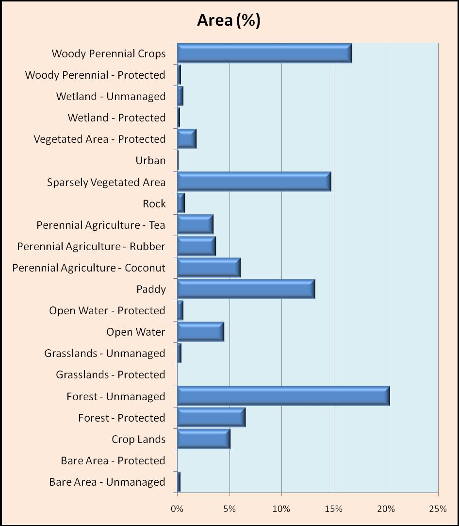
31 11 Forest Protected 12 Forest - Unmanaged 13 Woody Perennial - Protected 14 Vegetated Area Protected 15 Sparsely Vegetated Area Unmanaged 16 Grasslands Protected 17 Grasslands - Unmanaged 18 Bare Area Protected 19 Bare Area Unmanaged 21 Perennial Agriculture - Coconut 22 Perennial Agriculture - Rubber 23 Perennial Agriculture - Tea 24 Woody Perennial Crops 25 Crop Lands 26 Paddy 31 Urban 32 Rock 41 Wetland - Protected 42 Wetland - Unmanaged 43 Open Water Protected 44 Open Water
32
33
34

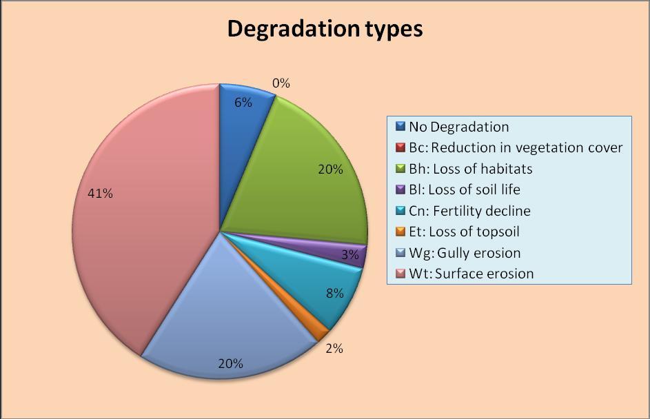
35 Combined Admin unit & LUS Map [ADMINCODE] & [0] & [LUSCODE]
36
37

38
39
40
41
42

43 CODE Bc Bh Bl Cn Et Wg Wt Degradation Type Reduction in Vegetation Cover Loss of Habitats Loss of Soil life Fertility Decline Loss of top soil Gully Erosion Surface Erosion
44

45 Almost whole of the Central Province is suffering from land degradation No or less degraded percentages were observed in areas with thick forest cover
46 Human induced factors Direct Drivers & Pressures Unsystematic use of lands for continuous annual cropping Haphazard / unplanned development activities Inappropriate land reclamation Mining & other industries Unscientific solid waste management particularly in urban areas Unsystematic landuses
47 Human induced factors Indirect Drivers & Pressures Population pressure Poverty Inadequate and / or inappropriate policies and management Lack of Land ownership Land fragmentation
48 Natural factors Rainfall characteristics, topography and soils (climate change???) Surface Erosion, Gully erosion, Loss of Habitats, Fertility Decline, Loss of Soil Life, and Loss of top soil are the degradation types taking place within the Central Province at present
49 (Munasinghe et al, 2001)

50 (Senanayake, S.S. et al., 2013)
51 Prevention & control measures implemented at field level Introduction of policy & legal framework Awareness creation, technical assistance & training Indiscriminate land use changes without considering the land suitability and capability should be avoided farmers should be supported in the selection and choice of crops for their cultivation depending on the location, climatic forecast and impending market behavior through an extensive extension service for agriculture.
52 Successive governments have used land resources to provide employment to the rural population This policy of providing land in lieu of employment opportunities should be discouraged Establishment of appropriate institutional framework and their coordination There are number of government organizations dealing with land management. However under local context coordination among those institutes are minimum or not existing at all. Hence there is need to promote and strengthen coordination among different organizations dealing with land resources management.
53 Providing alternative income generating opportunities There are number of government organizations dealing with land management. However under local context coordination among those institutes are minimum or not existing at all. Providing alternative income generating opportunities It is widely accepted that environmental degradation and poverty are closely linked. Rural community rely on natural resources mainly on land for survival but do not have the ability to invest on improvements to improve or conserve the resource base
54 Information System / Database Efficient monitoring program will help to understand the present situation and would be able to understand the current trend; thus provide information for decision making. Adaptation for Climate change Technical -Promote micro-irrigation where possible, Crop recommendation based on land suitability assessments, etc. Policy reforms - Strict enforcement of Soil Conservation Act, National Environmental Act and other related Ordinances


55 Source: Wikipedia Encyclopedia LADA Group of Sri Lanka 55
GIS Based Analysis of Biophysical and Socio - Economic Factors for Land Degradation in Kandaketiya DS Division
 Tropical Agricultural Research Vol. 21(4): 361-367 (2010) GIS Based Analysis of Biophysical and Socio - Economic Factors for Land Degradation in Kandaketiya DS Division K.D.B.L. Jayarathne, N.D.K. Dayawansa
The soil is a very. The soil can. The manure. Soil Characteristics. effective manure treatment system if manures are applied at the proper rate.
 The soil is a very effective manure treatment system if manures are applied at the proper rate. The soil can filter pollutants and prevent them from reaching groundwater. The manure application rate should
Soil Mapping, Classification and Land Use Planning. Environmental Management Branch Ontario Ministry of Agriculture, Food and Rural Affairs
 Soil Mapping, Classification and Land Use Planning Environmental Management Branch Ontario Ministry of Agriculture, Food and Rural Affairs Farmland Forum - March 2017 1 Pressures on Ontario s Soils Loss
METHODS OF IRRIGATION BY NAVANITA CHOUDHURY ASSISTANT PROFESSOR RSET
 METHODS OF IRRIGATION BY NAVANITA CHOUDHURY ASSISTANT PROFESSOR RSET CLASSIFICATION OF IRRIGATION METHOD A.Surface Irrigation: Water moves over and across the land by simple gravity flow in order to wet
Bio-Based Eco Industrial Clustering in Dambulla Sri Lanka
 Bio-Based Eco Industrial Clustering in Dambulla Sri Lanka Gemunu Herath and Uditha Ratnayake Department of Civil Engineering University of Peradeniya Sri Lanka Gemunu 1 Country Profile Sri Lanka Population
Status of climate change adaptation in agriculture sector for Lao PDR.
 Status of climate change adaptation in agriculture sector for Lao PDR. 1 st Rhine-Mekong Symposium Climate change and its influence on water and related sectors 8-9 May 2014, Koblenz, Germany Vanxay, DDMCC
State of Agriculture in the Uplands of Southern Mindanao
 State of Agriculture in the Uplands of Southern Mindanao (focused in UDP covered barangays) Aurea Christie Galvez-Lumaad, Environment Coordinator Resource Management Component Upland Development Programme
Very slight to negligible limitations no special land management practices required.
 Land Capability Classes Land and Soil Capability Class 1 Class 1 Definition Very slight to negligible limitations no special land management practices required. On-site impact of land management practices
Soil Degradation. Lesson Plan NRES B2-9
 Soil Degradation Lesson Plan NRES B2-9 Objectives 1. What is soil degradation? 2. How can construction result in soil degradation? 3. What are the sources of contamination, and how do they result in soil
LUS mapping LD/SLM assessment
 LUS mapping LD/SLM assessment Monica Petri, Lehman Lindeque KAGERA TAMP project Regional project workshop and steering committee meeting Kigali, 17-18 March 2011 Objectives build a geographical information
WATERSHED. Maitland Valley. Report Card 201
 Maitland Valley WATERSHED Report Card 201 The Maitland Valley Conservation Authority has prepared this report card as a summary on the state of our forests, wetlands, surface water, and ground water resources.
Land degradation in sloping uplands: economic drivers and strategies for promoting sustainable land use. Sushil Pandey
 Land degradation in sloping uplands: economic drivers and strategies for promoting sustainable land use Sushil Pandey Major issues Focus on soil erosion rather than on sustainable land use systems Limited
BASIC INFORMATION QUESTIONNAIRE
 Application No. Central Environmental Authority BASIC INFORMATION QUESTIONNAIRE Essential information to determine the environmental approval requirement of projects (Note Use separate sheets as and when
SUSTAINABLE LAND IN THE PHILIPPINES
 SUSTAINABLE LAND MANAGEMENT IN THE PHILIPPINES RODELIO CARATING AND RODRIGO BADAYOS BUREAU OF SOILS AND WATER MANAGEMENT AND UNIVERSITY OF THE PHILIPPINES LOS BAÑOS OUTLINE OF PRESENTATION INTRODUCTION
Chapter 9 Soil and Agriculture Guided Notes
 Chapter 9 Soil and Agriculture Guided Notes This lecture will help you understand: The relationship between and Major agricultural The fundamentals Causes and of soil erosion and Principles of soil No-till
CONCEPT OF SUSTAINABLE AGRICULTURE
 CONCEPT OF SUSTAINABLE AGRICULTURE Agriculture is the process of producing food, feed, fibre and other desired products by cultivation of certain plants and raising of domesticated animals. Agriculture
It is essential for the future wealth and wellbeing of the Region that this trend does not continue to diminish this finite resource.
 Auckland Regional Council Soil Conservation: 12 1 12.1 Introduction Soil resources have made an important contribution to the growth, prosperity and diversity of the Auckland Region. The Region s variety
Rangeland Watersheds. Maintenance and provision of genetic resources Maintenance and regeneration of habitat Provision of shade and shelter
 Rangeland Watersheds What is a Watershed? A surface water designation The area that flows into a distinct drainage (i.e., stream, river, creek, pond) Separated from other watershed by ridge-top boundaries.
1.3: Project Idea for Technology 2: Sustainable Land Management (SLM)
") i. Community Based Organization j. Central Environment Authority k. Sri Lanka Standard Institute 1.2.13 List of References 1. Amrasinghe, U.S. & Weerakoon, D.E.M. (2008) Present status and future strategies
i. Community Based Organization j. Central Environment Authority k. Sri Lanka Standard Institute 1.2.13 List of References 1. Amrasinghe, U.S. & Weerakoon, D.E.M. (2008) Present status and future strategies
Department of Agriculture. Eng. M.H.M.A. Bandara Chief Engineer. Country Report. Sri Lanka
 Country Report Sri Lanka Eng. M.H.M.A. Bandara Chief Engineer Department of Agriculture Agricultural Background Agricultural based country Arable land area- 1.887 mill ha. 1.0 mill ha. Under permanent
Improving Reclamation on Oil and Gas Well Pads in the Rocky Mountain West
 Improving Reclamation on Oil and Gas Well Pads in the Rocky Mountain West IPAMS 2008 ROCKY MOUNTAIN ENERGY TECHNOLOGY CONFERENCE September 5, 2008 Ed Redente, Ph.D. MWH Americas, Inc. 3665 JFK Parkway,
Stream Buffer: Kidneys of the Watershed?
 2012 A. D. Latornell Conservation Symposium Stream Buffer: Kidneys of the Watershed? John E. FitzGibbon Professor of Planning University of Guelph Definition a complex assemblage of plants and other organisms
Soils Soil Formation Soils of Hungary Land Degradation and Soil Fertility
 Soils Soil Formation Soil is the uppermost part of the weathered surface layer of Earth, developed within the interaction zone of the lithosphere, atmosphere, hydrosphere and biosphere under the integrated
SRI LANKA. Drought Impact Assessment and Monitoring using Computer Assisted Telephone Interviewing (CATI) Services. August 2017
 Services. August 2017") SRI LANKA Drought Impact Assessment and Monitoring using Computer Assisted Telephone Interviewing (CATI) Services Implemented By: Ministry of Disaster Management Assessment Technical Lead: United Nations
SRI LANKA Drought Impact Assessment and Monitoring using Computer Assisted Telephone Interviewing (CATI) Services Implemented By: Ministry of Disaster Management Assessment Technical Lead: United Nations
LESSON TEN: What Is an Ecological Site and What Causes Plant Community Change?
 LESSON TEN: What Is an Ecological Site and What Causes Plant Community Change? Ecological Sites Ecological sites are a distinctive kind of land that is different from all other kinds of land based on soil
WASA Quiz Review. Chapter 2
 WASA Quiz Review Chapter 2 Question#1 What is surface runoff? part of the water cycle that flows over land as surface water instead of being absorbed into groundwater or evaporating Question #2 What are
Ministry of Mahaweli Development and Environment The Democratic Socialist Republic of Sri Lanka. Land Degradation Neutrality Targets for Sri Lanka
 Ministry of Mahaweli Development and Environment The Democratic Socialist Republic of Sri Lanka Land Degradation Neutrality Targets for Sri Lanka Colombo, Sri Lanka December 2017 2 The Context Sri Lanka
Of vital importance..
 Soil moisture Of vital importance.. Low and erratic rainfall form a significant cause of low crop production and crop failure in rainfed agriculture in the tropics However, crop and land management do
Agricultural Adaptation Practices in South Asia : Experience of Farmers in Sri Lanka
 Agricultural Adaptation Practices in South Asia : Experience of Farmers in Sri Lanka Athula Senaratne, Research Fellow Institute of Policy Studies Sri Lanka Outline Climate change and farmers Climate and
3.2 How Humans Influence Ecosystems
 3.2 How Humans Influence Ecosystems Human intrusion has caused many BC wetlands to disappear. In the past 100 years up to 70% of the wetlands in the lower Fraser Valley have been lost. Wetlands are special
1.6 Influence of Human Activities and Land use Changes on Hydrologic Cycle
 1.6 Influence of Human Activities and Land use Changes on Hydrologic Cycle Watersheds are subjected to many types of changes, major or minor, for various reasons. Some of these are natural changes and
Drivers of deforestation and forest degradation in Houaphan province
 Final consultation workshop of the Provincial REDD+ Action Plan (PRAP) Development Process Drivers of deforestation and forest degradation in Houaphan province Houaphan November 24 th, 2016 Presentation
Status of Soil Resources in Lebanon
 Status of Soil Resources in Lebanon By Roger FRANCIS CNRS-National Center for Remote Sensing Jordan Amman 1-5 April 2012 Status of environment and coastal ecosystem State of the art on soil studies in
1. Introduction. Keywords Groundwater, Vulbnerability, Aquifer, Aquitard, Vadose zone. Alsharifa Hind Mohammad
 World Environment 2014, 4(1): 22-32 DOI: 10.5923/j.env.20140401.03 New Groundwater Vulnerability Index for the Main Aquifers in Central Catchment Area in Jordan and Validation of the Results Using NO 3
phosphorus in catchments
 Managing 11 phosphorus in catchments Phosphorus is an essential component of all plants and animals, and is a natural part of the rocks that comprise the earth s crust. While phosphorus is a natural and
Maitland Valley WATERSHED
 Maitland Valley WATERSHED Report Card 2018 Maitland Conservation has prepared this report card as a summary of the state of your forests, wetlands, and water resources. WHERE ARE WE? We are one of 36 Conservation
AnnAGNPS. Annualized AGricultural Non-Point Source Pollurant Loading Model. Annualized Agricultural Non-Point Source Pollutant Loading Model
 AnnAGNPS Annualized AGricultural Non-Point Source Pollurant Loading Model 1 Erosion Erosion can be expresed as: E=f(C, S, T, SS, M) E = erosion C = climate S = soil properties T = topography SS = soil
Class Principal Soils
 LAND RESOURCES Soil Characteristics Soils in the hilly regions are formed from material weathered from granitic gneiss and other igneous or metamorphosed rocks. They belong to the Chester-Glenville-Brandywine
Greening Agriculture Policies and Laws
 Greening Agriculture Policies and Laws What? Greening agricultural business is introducing environmental measures to result in sustainable economic benefits - reducing overconsumption (losses pollution,.
Davood Nikkami (PhD)
") Country Report of The IR. Iran 28-30 Jan., 2009, Bangkok, Thailand Workshop on Improving Agricultural Productivity, Water Use Efficiency & Strengthening Rural Livelihoods Davood Nikkami (PhD) Soil Conservation
Country Report of The IR. Iran 28-30 Jan., 2009, Bangkok, Thailand Workshop on Improving Agricultural Productivity, Water Use Efficiency & Strengthening Rural Livelihoods Davood Nikkami (PhD) Soil Conservation
Radical Terraces Rwanda - Amaterasi y'indinganire
 Radical Terraces Rwanda - Amaterasi y'indinganire Locally referred to as radical terracing, the method involves earth moving operations that create reverse-slope bench terraces which have properly shaped
Forest & Range Evaluation Program
 Forest & Range Evaluation Program Riparian Management Effectiveness & the Fish Value Post-Harvest Assessments of Riparian, Stream, & Fish Habitat Conditions Peter J. Tschaplinski Ministry of Environment
Lecture 1 Integrated water resources management and wetlands
 Wetlands and Poverty Reduction Project (WPRP) Training module on Wetlands and Water Resources Management Lecture 1 Integrated water resources management and wetlands 1 Water resources and use The hydrological
SALT IN THE SOIL By Prof. R.B. Mapa, Dr. W.M.A.D.B. Wickramasinghe, D.N. Sirisena and K.M.A. Kendaragama
 SALT IN THE SOIL By Prof. R.B. Mapa, Dr. W.M.A.D.B. Wickramasinghe, D.N. Sirisena and K.M.A. Kendaragama Soil Science Society of Sri Lanka P.O. Box 10, Peradeniya. Email: soilscisoclk@yahoo.com Due to
1.2. Net change in land cover [ha]
![1.2. Net change in land cover [ha]](/thumbs/72/67518217.jpg "1.2. Net change in land cover [ha]") Land cover 2006 Overview of land cover & change After the large political and economical changes in Slovakia during 90 s, the period is characterised by stabilization - rapid decrease of overall intensity
Land cover 2006 Overview of land cover & change After the large political and economical changes in Slovakia during 90 s, the period is characterised by stabilization - rapid decrease of overall intensity
Contents: Purpose and objective Water and energy conservation 1 1
 1 Chapter 1 Contents: 652.0100 Purpose and objective 1 1 652.0101 Water and energy conservation 1 1 652.0102 Soil conservation, water quality, and pollution abatement 1 2 652.0103 Using the guide 1 3 (a)
Estimation of runoff for agricultural watershed using SCS Curve Number and Geographic Information System
 Estimation of runoff for agricultural watershed using SCS Curve Number and Geographic Information System Ashish Pandey 1,V.M.Chowdary 2, B.C.Mal 3 and P.P.Dabral 1 ABSTRACT Soil Conservation Service (SCS)
Environmental Resource Inventories. What are ERIs? Significance of information How to use them
 Environmental Resource Inventories What are ERIs? Significance of information How to use them Environmental Resource Inventory - ERI Compiled by the environmental commission Information about the natural
COMBATING CLIMATE CHANGE AND LAND DEGRADATION IN THE WEST AFRICAN SAHEL: A MULTI-COUNTRY STUDY OF MALI, NIGER AND SENEGAL
 COMBATING CLIMATE CHANGE AND LAND DEGRADATION IN THE WEST AFRICAN SAHEL: A MULTI-COUNTRY STUDY OF MALI, NIGER AND SENEGAL BY PROF. S.A. IGBATAYO HEAD, DEPARTMENT OF ECONOMICS & MANAGEMENT STUDIES AFE BABALOLA
Multiple cropping systems in uplands of central Japan
 Cropping systems in Japan 69 6 Multiple cropping systems in uplands of central Japan Kazutoshi Hoshikawa Faculty of Agriculture, Shinshu University, Nagano 384-4598, Japan Introduction Japan is a mountainous
Soil Treats, Gaps, and Technical Assessment. Agricultural University of Athens Costas Kosmas
 Soil Treats, Gaps, and Technical Assessment Agricultural University of Athens Costas Kosmas Identified important threats to European soils The European Commission adopted a Soil Thematic Strategy (COM(2006)
Participatory risk assessment and monitoring
 Integrated Local Risk Management Participatory risk assessment and monitoring (Draft 19.06.09) Guidelines for baseline assessment and monitoring 1 Strengths and limits of ILRM and its participatory risk
Potential and constraints for intensive land use with pond irrigation in north-east Thailand
 Intensive land use with ponds in Thailand 89 8 Potential and constraints for intensive land use with pond irrigation in north-east Thailand Masuo Ando Development Research Division C Japan International
Impact of Land Use and Land Cover Changes on Ecosystem Services in Southwest China
 Impact of Land Use and Land Cover Changes on Ecosystem Services in Southwest China Presented by HU Huabin OUTLINE Introduction Methods Results Discussion Ecosystem services refer to the conditions and
Nebraska Soil Science Curriculum
 Nebraska Soil Science Curriculum Soil Quality Measurement Approximately 180 minutes ***Content and lab derived from the USDA-NRCS Guides for Educators. Please see the Guides for additional helpful pictures
awetlands aprairie aforests ahabitat for Fish, Game & Wildlife
 Rec. H1 priority land habitats pp. 63-67 Priority areas identified in integrated mapping assessing critical land habitat and threats to habitat pp.33-63 o Mapping is scalable for use in localized areas
FACTSHEET INTRODUCTION. help rebalance the water cycle, mitigate the effects of climate change and improve human health and livelihoods.
 1 FACTSHEET INTRODUCTION World Water Day, on 22 March every year, is about focusing attention on the importance of water. This year s theme, Nature for Water, explores nature-based solutions (NBS) to the
Trenches combined with living hedges or grass lines Rwanda - Imiringoti
 Trenches combined with living hedges or grass lines Rwanda - Imiringoti Trenches combined with living hedges or grass lines are slow-forming terraces to control soil erosion by changing the length of the
Country fact sheet. Land cover Switzerland. September Photo: Toni García, My City/EEA
 Country fact sheet Land cover 2012 Switzerland September 2017 Photo: Toni García, My City/EEA Land cover 2012 Overview of land cover & change In the long term, the Swiss landscape shows very low intensity
Assessment and mapping of GRASSLAND ecosystems condition and their services in Bulgaria, Contr. Д-33-90/
 1 General typology of grassland ecosystems We consider Grassland ecosystem as a natural or seminatural vegetation type. It could be part of farm holdings like pastures, meadows, uncultivated lands, etc.
Assessing agricultural vulnerability to climate change in Sri Lanka
 Sri Lanka Journal of Food and Agriculture (2015) Niranjan et al. 1(1): 85-92 ISSN 2424-6913 Research Paper Assessing agricultural vulnerability to climate change in Sri Lanka F. Niranjan 1, N.P.C. Uddika
Changes in Area and Quality of Cultivated Land in China
 1 Changes in Area and Quality of Cultivated Land in China Qinxue WANG* and Kuninori OTSUBO* * National Institute for Environmental Studies, 16-2 Onogawa, Tsukuba, Ibaraki 305-8506, Japan Abstract: In this
CATCHMENT AREA TREATMENT PLAN
 CATCHMENT AREA TREATMENT PLAN 1 NEED FOR CATCHMENT AREA TREATMENT It is a wellestablished fact that reservoirs formed by dams on rivers are subjected to sedimentation. The process of sedimentation embodies
BAEN 673 / February 18, 2016 Hydrologic Processes
 BAEN 673 / February 18, 2016 Hydrologic Processes Assignment: HW#7 Next class lecture in AEPM 104 Today s topics SWAT exercise #2 The SWAT model review paper Hydrologic processes The Hydrologic Processes
July, International SWAT Conference & Workshops
 Analysis of the impact of water conservation measures on the hydrological response of a medium-sized watershed July, 212 212 International SWAT Conference & Workshops ANALYSIS OF THE IMPACT OF WATER CONSERVATION
Watershed BMPs. Notes from NRCS online site on BMPs. Focus on key BMPs
 Notes from NRCS online site on BMPs http://www.nrcs.usda.gov/technical/standards/nhcp.html Focus on key BMPs Function, benefits, and drawbacks listed Definition Novotny & Olem: BMPs are methods and practices
Soil Organic Matter. Soil degradation has become a major concern in. What is organic matter? Organic matter in virgin and cultivated soils
 Agdex 6- Soil degradation has become a major concern in Canada. Erosion, salinization, acidification and loss of organic matter are the main forms of soil deterioration. This factsheet deals with the role
Responses to LEDD in Cropland Agricultural University of Athens Costas Kosmas
 Responses to LEDD in Cropland Agricultural University of Athens Costas Kosmas Policy Conference: Research on Responses to Land degradation and Desertification in croplands Berlin, 17 March 2014 Objectives
Sustainable soil Management in Tanzania
 Sustainable soil Management in Tanzania Population: 45 million 7.1 Million ha 75% depend on Agriculture 95% source of food from smallholder farmers Agriculture sector contributes 31.7% of GDP 7 Farming
orking Trees for Water Quality
 W Agroforestry orking Trees for Water Quality Working Trees: a partner in watershed management. Agroforestry helps to protect water quality while achieving both landowner and community objectives. Water
Drought Impact Assessment and Monitoring using Computer Assisted Telephone Interviewing (CATI) Services
 Services") SRI LANKA Drought Impact Assessment and Monitoring using Computer Assisted Telephone Interviewing (CATI) Services Assessment Technical Lead: United Nations World Food Programme 1 August 2017 EXECUTIVE
SRI LANKA Drought Impact Assessment and Monitoring using Computer Assisted Telephone Interviewing (CATI) Services Assessment Technical Lead: United Nations World Food Programme 1 August 2017 EXECUTIVE
Identifying drivers of land use change and type of degradation
 Capacity-Building Workshop for Europe on ecosystem conservation and restoration to support achievements of the Aichi Biodiversity Targets, 2 to 6 June, Isle of Vilm, Germany 2001 Identifying drivers of
Land use type and indicators affecting land degradation and desertification. C. Kosmas Agricultural University of Athens
 Land use type and indicators affecting land degradation and desertification C. Kosmas Agricultural University of Athens Desertification The consequence of a series of important degradation processes in
D.G.S.W. Pitakumbura Manager (Groundwater Studies) Groundwater Section NWS&DB. Groundwater recharge or deep drainage or
 Groundwater Section NWS&DB. Groundwater recharge or deep drainage or") Groundwater Recharge and Extraction Techniques D.G.S.W. Pitakumbura Manager (Groundwater Studies) Groundwater Section NWS&DB What is Groundwater Recharge Groundwater recharge or deep drainage or deep percolation
Groundwater Recharge and Extraction Techniques D.G.S.W. Pitakumbura Manager (Groundwater Studies) Groundwater Section NWS&DB What is Groundwater Recharge Groundwater recharge or deep drainage or deep percolation
Nichole M. Embertson, Ph.D. Whatcom Conservation District. May 2, 2012 Abbotsford-Sumas Aquifer Groundwater Nitrate Science Forum Abbotsford, CN
 Nichole M. Embertson, Ph.D. Whatcom Conservation District May 2, 2012 Abbotsford-Sumas Aquifer Groundwater Nitrate Science Forum Abbotsford, CN Background ARM System Assessment Development Implementation
ASSESSMENT OF A MANGROVE REHABILITATION PROGRAMME USING REMOTE SENSING AND GIS: A CASE STUDY OF AMPHUR KHLUNG, CHANTABURI PROVINCE, EASTERN THAILAND
 ASSESSMENT OF A MANGROVE REHABILITATION PROGRAMME USING REMOTE SENSING AND GIS: A CASE STUDY OF AMPHUR KHLUNG, CHANTABURI PROVINCE, EASTERN THAILAND Korn Manassrisuksi 1 Michael Weir 2 Yousif Ali Hussin
Analysis of the Agriculture- Environment Nexus
 Analysis of the Agriculture- Environment Nexus Evolving concepts and approaches Anna Tengberg & Isabelle Batta-Torheim Division of GEF Coordination United Nations Environment Programme (UNEP) Overview
Evaluating the Reduction Effect of Nonpoint Source Pollution Loads from Upland Crop Areas by Rice Straw Covering Using SWAT
 SESSION J2 : Water Resources Applications - I New Delhi, India 2012 International SWAT Conference Evaluating the Reduction Effect of Nonpoint Source Pollution Loads from Upland Crop Areas by Rice Straw
Testing Framework for Sustainable Biomass ("Cramer Criteria") - The Netherlands
 - The Netherlands") Testing Framework for Sustainable Biomass ("Cramer Criteria") - The Netherlands Country/ Organization Initiative Membership - Governing bodies - Type and implementation approach Feedstock(s) covered Type(s)
Testing Framework for Sustainable Biomass ("Cramer Criteria") - The Netherlands Country/ Organization Initiative Membership - Governing bodies - Type and implementation approach Feedstock(s) covered Type(s)
THE CONCEPT OF ORGANIC FARMING:
 INTRODUCTION : Agriculture is one of the oldest and most fundamental primary occupation of all human beings since stone age. It is a foundation of all social Cultural and Economical condition of mankind.
Special Seminar on Food Security: Focusing on Water management and Sustainable Agriculture
 Special Seminar on Food Security: Focusing on Water management and Sustainable Agriculture Kyi Myint Ministry of Agriculture and Irrigation Location Latitude 9 58-28 31 N Longitude 92 9-100 10 E Country
Country fact sheet. Land cover Romania. September Photo: Toni García, My City/EEA
 Country fact sheet Land cover 2012 Romania September 2017 Photo: Toni García, My City/EEA Land cover 2012 Overview of land cover & change The Romanian landscape is characterised by its low dynamics of
Agro-ecosystems functioning under stress Ilan Stavi
 Agro-ecosystems functioning under stress Ilan Stavi Dead Sea & Arava Science Center, Israel istavi@adssc.org The northern Negev 1. Dryland wheat agro-pastoral systems: Functioning and soil organic carbon
STATUS, PRIORITIES AND NEEDS FOR SUSTAINABLE SOIL MANAGEMENT IN JAMAICA
 STATUS, PRIORITIES AND NEEDS FOR SUSTAINABLE SOIL MANAGEMENT IN JAMAICA Presented by Joan Brown Morrison Rural Physical Planning Division, Ministry of Agriculture and Fisheries Global Soil Partnership:
Rhode Island Soil Health Worksheet
 Rhode Island Health Worksheet Client: Field: Address: Date: Indicator Worst------------------------------------------------>Best Descriptions 1 2 3 4 5 6 7 8 9 10 Poor (1-3) Fair (4-7) Excellent (8-10)
Names: ESS 315. Lab #6, Floods and Runoff Part I Flood frequency
 Names: ESS 315 Lab #6, Floods and Runoff Part I Flood frequency A flood is any relatively high flow of water over land that is not normally under water. Floods occur at streams and rivers but can also
National context NATIONAL CONTEXT. Agriculture and the Sustainable Development Goals in the Lao PDR
 National context Agriculture and the Sustainable Development Goals in the Lao PDR Agriculture plays a central role as a foundation of the Lao PDR s overall national economy and development, particularly
STATUS, NEEDS AND PRIORITIES FOR SUSTAINABLE SOIL MANAGEMENT IN SIERRA LEONE
 STATUS, NEEDS AND PRIORITIES FOR SUSTAINABLE SOIL MANAGEMENT IN SIERRA LEONE Presentation at the Launch of Global Soil Partnership in Accra, Ghana (4-6 February, 2013) By Susan A. Robert Soil Scientist
DEVELOPING AGRI-ENVIRONMENTAL INDICATORS FOR CANADA GENERAL PROPOSAL
 DEVELOPING AGRI-ENVIRONMENTAL INDICATORS FOR CANADA GENERAL PROPOSAL MARCH 1994 (description of proposed water quality indicator modified in June 1994) ENVIRONMENTAL INDICATOR WORKING GROUP AGRICULTURE
28-31 August 2017 Bari, Italy
 Improved Agricultural water uses Workshop 28-31 August 2017 Bari, Italy Reduce vulnerability in Jordan in the context of water scarcity and increasing food /energy demand Al-Ghadeer Al-Abyad watershed
Stone lines Uganda - Ennyiriri z'amayinja eziziyiza ettaka okutwalibwa enkuba (Luganda)
") Stone lines Uganda - Ennyiriri z'amayinja eziziyiza ettaka okutwalibwa enkuba (Luganda) Stone lines are built along a contour to control soil erosion on a degraded steep slope. left: Stone lines established
Stone lines Uganda - Ennyiriri z'amayinja eziziyiza ettaka okutwalibwa enkuba (Luganda) Stone lines are built along a contour to control soil erosion on a degraded steep slope. left: Stone lines established
Agriculture and Society: Part II. PA E & E Standards 4.4
 Agriculture and Society: Part II PA E & E Standards 4.4 Let s get Dirty! 1. All agriculture ultimately depends on the soil. What is soil? Soil is the upper layer of the land surface that contains pieces
BMP 5.4.2: Protect /Conserve/Enhance Riparian Areas
 BMP 5.4.2: Protect /Conserve/Enhance Riparian Areas The Executive Council of the Chesapeake Bay Program defines a Riparian Forest Buffer as "an area of trees, usually accompanied by shrubs and other vegetation,
Improving the physical conditions of the paddy fields with irrigated paddy rice and upland crop rotation by no-till and no-puddled rice culture
 Symposium no. 22 Paper no. 1075 Presentation: poster Improving the physical conditions of the paddy fields with irrigated paddy rice and upland crop rotation by no-till and no-puddled rice culture OTA
Questions and answers on the Thematic Strategy on soil protection
 MEMO/06/341 Brussels, 22 September 2006 Questions and answers on the Thematic Strategy on soil protection Why is soil important? Soil is literally one of the foundations for our economic prosperity and
From the Ground Up- Field Soil Considerations
 From the Ground Up- Field Soil Considerations Ted Bilderback Nursery Extension Specialist Department of Horticulture Science North Carolina State University Ted_Bilderback@ncsu.edu http://www.ces.ncsu.edu/depts/hort/nursery/
Welcome to the MWON Advanced Webinar Series
 Welcome to the MWON Advanced Webinar Series Today s presentation: The Importance of Forests to Streams and Groundwater You will need to have speakers attached to your computer to hear the presenter. You
Country fact sheet. Land cover Slovakia. September Photo: Toni García, My City/EEA
 Country fact sheet Land cover 2012 Slovakia September 2017 Photo: Toni García, My City/EEA Land cover 2012 Overview of land cover & change With the overall land cover change rate of 0.3 of total area,
S i o l A c A idi d fication o n and n d Fe F rtility y St S atus u of o Ne N pa p l Backgr g ou o n u d
 Soil Acidification and Fertility Status of Nepal Background Nepal - 80 0 4 and 88 0 12 E longitude & 26 0 22 and 30 0 27 N latitude. China in North and India in the East, South India and West Total land
Country fact sheet. Land cover Liechtenstein. September Photo: Toni García, My City/EEA
 Country fact sheet Land cover 2012 Liechtenstein September 2017 Photo: Toni García, My City/EEA Land cover 2012 Overview of land cover & change As in previous periods, the land cover development in the