AGRICULTURE & FOOD SECURITY. The Rangelands Decision Support Tool. Vegetation & Surface Water Monitoring
|
|
|
- Erica Williamson
- 5 years ago
- Views:
Transcription


1 AGRICULTURE & FOOD SECURITY The Rangelands Decision Support Tool Vegetation & Surface Water Monitoring Lilian Ndungu James Wanjohi

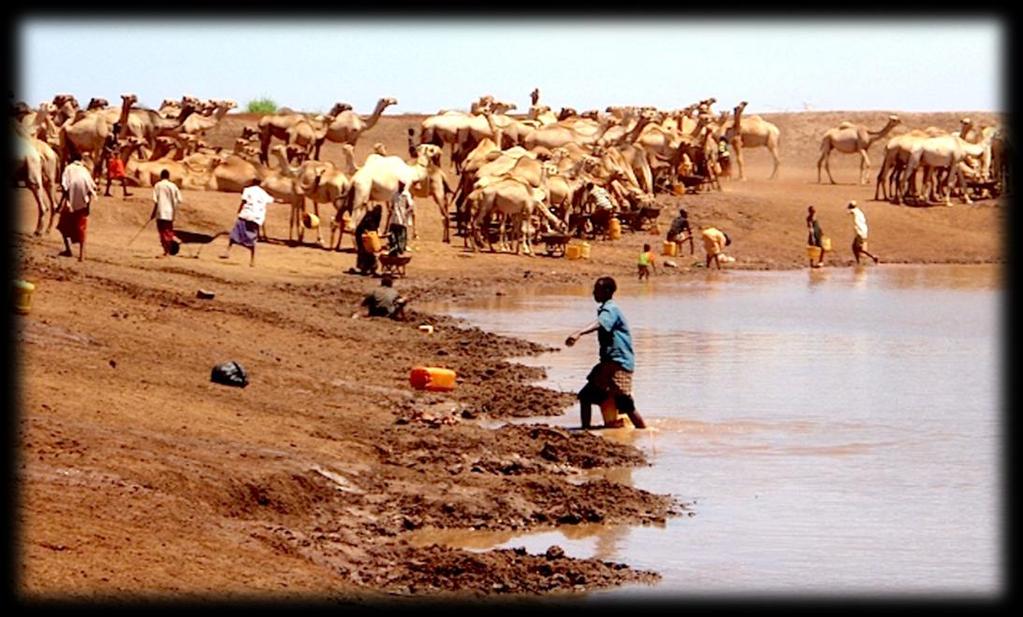

2 Pasture Image Courtesy of Oxfam at Water Image Courtesy of

3 Select County/Conservancy Boundary select indicators (NDVI, NDVI anomalies, VCI at dekadal, monthly and seasonal time steps) Combine with other relevant layers (Surface water maps(sentinel), Invasive species, towns, wards Why A lot of EO indicators for vegetation productivity exist No specific tool offers users with Centralized location for different indicators Aggregation capabilities based on selection Synthesis for Decision making Dis-aggregation at sub-regional level(county/conservancy) Download of both processed maps and GIS data produce maps at county/conservancy Download the maps in PDF or GIS format


4 The Rangelands Decision Support Tool Processing Automatic Data processing Web based tool Template


5 NDVI Index of plant greenness Can be used to monitor changes in vegetation over time, grazing impacts related to grazing management and plans, changes in land cover, rangeland condition and the type of vegetation. Kalama 10 th January 2018 Kalama 30 th January 2018 Kalama 20 th February 2018 Bare Sparse Dense


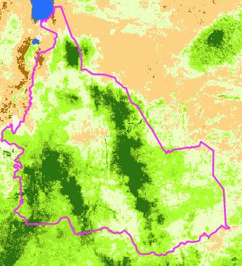
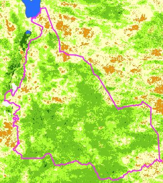
6 NDVI - MELAKO Oct 2017 Nov 2017 Dec 2017 Jan 2018 Feb Feb


7 Seasonal assessment- Long rains PPT trend MAM NDVI 2007 MAM NDVI 2017 MAM STD ANOM 2007 MAM STD ANOM 2007


8 Seasonal assessment- Short rains PPT trend OND NDVI 2007 OND NDVI 2017 OND STD ANOM 2007 OND STD ANOM 2017

.")


9 Standardized NDVI anomalies (SERA) Highlight deviations from normal vegetation development (either positive or negative). Gives a qualitative indication of how "good" or "bad" the current season is when compared with other seasons or with the average situation. Jan 2018 Dec 2017 Nov 2017 Oct 2017 Worsening No Change Improving


10 Absolute NDVI Anomalies Represent difference from long term mean Are conditions above or below normal? Jan 2018 Jan 2017 Jan 2016 Jan 2015 Decline No Change Improving


11 Vegetation Condition Index (VCI) October 2017 February 2017 An indicator of the current activity of the vegetation relative to the historical range Monitoring performance of vegetation based on Historical conditions. Low value implies vegetation performs quite poor as compared to the historic range of values. VCI values below 35 are usually considered to indicate drought conditions


12 Why Map Water Resources


, 30 m (16 days), and 10 m (5 days)) Multi-sensor studies Freely available")
13 Solutions The need and climatic changes Blocks Holding capacity Data and / information to GapsWeather support decisions that are made Inputs to grazing / livestock plans Low costs solutions In average Perform trend analysis (historical information) Monitoring over time Transient nature of water Advantages High speed processing Satellite imagery acquisition and analysis (repository) Higher temporal and spatial imagery (250m (2 day observations), 30 m (16 days), and 10 m (5 days)) Multi-sensor studies Freely available data

14 EO for monitoring LandSAT Sentinel Polygon Water Extent Lake Logipi Nov to Dec


15 Time Series 2016-Dec to 2017-May Information based - Decisions NOV - DEC DEC - JAN JAN - FEB FEB - MAR MAR - APR


16 Water resources and Degradation February 2017 Standardized anomalies
17 Target Audience County NDMA officers Stakeholders in the Rangelands Kenya RAPID NRT Lewa LWF
 HiSense Project Monitoring borehole performances and Link vegetation conditions and rainfall in")
18 Way forward Add analytical capabilities ie graphs Add water layers for monitoring Linkage with other products/partners/stakeh olders Capacity building (DOI, Others) HiSense Project Monitoring borehole performances and Link vegetation conditions and rainfall in ASALs
19 Capabilities Access to near real time greenness indices Ability add overlay data Generate maps Variety of indicators at different time steps Visualization and analytics Ability to plug in User specific Data


20 Sample map outputs October & December


21 Sample map outputs December & January
 for the MAM season Turkana Mandera Marsabit Legend Annual")


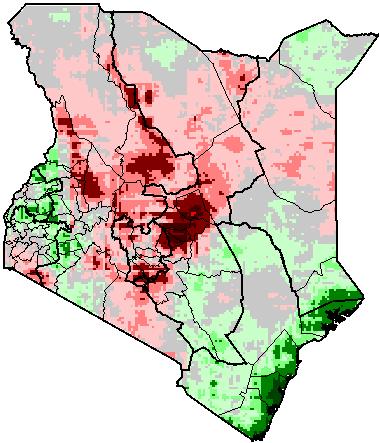
22 Impact of Climate variability in Kenya Drylands Precipitation Anomaly ( ) against a baseline LTA ( ) for the MAM season Turkana Mandera Marsabit Legend Annual Precipitation Trend ( ) West Pokot Samburu Trans Nzoia Keiyo-Marakwet Isiolo Bungoma Baringo Uasin Gishu BusiaKakamega Laikipia VihigaNandi Meru Siaya Kisumu Nyandarua Tharaka Kericho Nakuru Nyeri Homa Bay Bomet Embu Kisii Nyamira Murang'aKirinyaga Migori Kiambu Narok NairobiMachakos Kitui Tana River Wajir Garissa Kenya County Boundary Vulnerable Areas MAM Rainfall Anomalies High : 106 Low : -91 Western region experienced above average precipitation and an increasing trend Kajiado Parts of the main production areas experienced below average precipitation Makueni Lamu Kilifi Taita Taveta Mombasa KwaleMombasa Kenya Drylands where below average precipitation was experienced. On the long term, a decreasing trend in precipitation was also observed
23 Changes in Croplands Between 2001 and 2015 Total change: 5394km 2 of land converted to cropland 3370km 2 conversion to maize production 318sqkm converted from maize to other crops/other land use types Laikipi a Meru In Kenya s drylands, agricultural intensification was more dominant despite below average precipitation and a decreasing precipitation trend being observed. These include parts of Kitui, Machakos, Makueni, Meru, Kajiado Counties. Machakos Kitui Legend Kenya County Boundary 1 Non Cropland to Cropland 2 Cropland to Non Cropland


24 SDA Bulletin on crop conditions & Early warning CROP CONDITIONS REPORT: 2017 Long rains & Short Rains CROP CONDITIONS REPORT: March 2018 Crop condition map showing crop conditions information in Kenya regions as of March 21 st Crop conditions over the main growing areas are based on a combination of inputs including remotely sensed data, ground observations, field reports, national, and regional experts. Conditions that are other than favorable are labeled on the map with their driver. SUMMARY The Assessment focused long rains season. Overall Crop conditions for the Long rains were reported as favourable in most counties for Maize, Beans and Wheat due to wet conditions reported with the timely onset of the rains. However the Northern rift valley is on watch due to dry conditions. In most areas, land preparation is complete and planting is in process with some of the areas already having germinated crops. Outlook: It is expected that the crops are liketely to perform well if the favourable weather conditions prevail throughout the critical development stages of the crop. Crop condition map showing crop conditions information in Kenya regions as of February 23 rd Crop conditions over the main growing areas are based on a combination of inputs including remotely sensed data, ground observations, field reports, national, and regional experts. Conditions that are other than favorable are labeled on the map with their driver. SUMMARY The Assessment focused on Maize in both Long and Short rains seasons while beans and wheat were reported only for the Long rains seasons. Overall Crop conditions for the Long rains were reported as favourable in most counties for Maize, Beans and Wheat. However, poor conditions were reported for maize in the short rains season. Currently, in most areas, farmers are preparing land in readiness for planting in the Long Rains season While overall crop conditions for maize, beans and wheat were favorable in most counties reported in the Long Rains (LR), maize conditions during the Short Rains(SR)was reported as poor due to prevailing dry conditions. While maize in the Long Rains season performed well, in Bomet, maize was under watch due to dry conditions with crops showing moisture stress*. Most regions reported poor conditions for Maize in the Short Rains (SR) due to early cessation of short rains leading to late planted crops to suffer from severe water stress. However, maize crop performed well in Migori, Nyamira, Narok and Uasin Gishu since conditions were favorable. During the Long Rains, Reports from Uasin Gishu and Narok established favorable conditions being experienced resulting in favorable yields. Currently farmers are preparing land in readiness for the Long Rains Season. Beans performed well in the Long Rains, despite late onset of rainfall. In most areas, land preparation in readiness for the Long Rains is ongoing/completed. GHACOF Outlook- MAM 2018 The prediction of MAM 2018 season indicates increased likelihood of near normal to enhanced rainfall over the country. Average to wet conditions expected in Western Kenya However, near normal to depressed rainfalls are likely to occur in Eastern Kenya. Region Specific Assessment In central province, crops are germinating well with favorable crop conditions expected since rains are expected to continue. In Muranga, Nyandarua, Nyeri, county, the farmers completed land preparation in readiness for planting of maize from mid- March. Land preparation is ongoing with the onset of rains in preparation for planting of wheat in the Coast Province. Despite prevailing dry conditions, the situation is expected to improve as the season progresses. In Taita Taveta, irrigation is expected to support crop production. In North Rift, delayed land preparation and delays in access to inputs has resulted in late planting. Expected below-average rainfall will also impact crop conditions in the region as rainfall is expected to be below average during the vegetative phase. In South Rift, the crop stage ranges from germination to seedling to top dressing. The condition of the crop has tremendously improved with the rains and trend is expected to continue. In Western Kenya, onset of rains has precipitated planting of beans and maize in most of the region, with favorable conditions expected to continue. Flooding likely to occur in the lower areas like Budalangi with increasing rainfall. In Nyanza, maize planting is complete with crop stage ranging from germination to 6 leaf stage. The growing conditions are expected to continue being favorable for both maize and beans. Land preparation and planting for the season is set to continue in the next month with Weeding of the early planted crop to continuing in Eastern Kenya. The upper eastern region which is generally dry is experiencing favorable conditions with the onset of rainfall. Land preparation and planting for the season is set to start in the next month for wheat. GHACOF Outlook- MAM 2018 The prediction of MAM 2018 season indicates increased likelihood of near normal to enhanced rainfall over the country. Average to wet conditions expected in Western Kenya However, near normal to depressed rainfalls are likely to occur in Eastern Kenya. Precipitation Forecast- Early April Most parts of the country are expected to continue receiving rainfall with Central and Eastern Kenya expected to experience high rainfall amounts. However North Western Kenya is expected to receive little amount of rainfall (less than 5mm) or remain generally dry
25 THANK YOU