Lune Rivers Trust INNS Strategic Plan 2015 Lancaster District
|
|
|
- Jeffery Rich
- 5 years ago
- Views:
Transcription

1 Lune Rivers Trust INNS Strategic Plan 2015 Lancaster District Written & compiled by Ben Myerscough, Sarah Littlefield & Louisa Blundell
2 The Lune Rivers Trust Strategic Plan for the controlling of Invasive Non-native Species (INNS) is divided into separate sections for clarity. Further details in these sections, such as contact information, can be obtained through The Lune Rivers Trust. Contents Introduction to the Area Projects Appendix A - Funding Appendix B - Stakeholder Engagement Appendix C - Monthly Reports Appendix D - Actions Table Appendix E - Species Identification Appendix F - Species Information & Distribution Appendix G - Species Control methods & Calendar of control times Introduction to the Area The Lancaster area has a rich history with high dependence on the Lune rivers and surrounding canals. Morecambe, for example, relied heavily on the surrounding bathing waters for their tourism whilst Lancaster and the smaller towns around it depended on the Lancashire Canal for transportation of goods. Facts and Figures Area: 222 Square miles (575 km 2 ) Population: approx. Main Rivers (In Lune Catchment): Cocker, Lune, Overton Dyke, Burrow Beck, Conder Key Features: Nuclear power station (Heysham), part of bathing water catchment, Lancashire Canal, Leighton Moss RSPB reserve, Arnside & Silverdale AONB, Forest Of Bowland AONB Major Infrastructure: Motorway + junctions, railway, main roads, ferry port Major Urban Areas (In Lune Catchment): Lancaster, Carnforth, Morecambe, Hest Bank, Heysham, Galgate Projects INNS Strategic Plan
3 The Lune Rivers Trust EA INNS project works with many partners to eradicate/ control the spread of INNS, in particular Japanese Knotweed, Himalayan Balsam and Giant Hogweed. We aim to do this with a five step programme outlined in this, our strategic plan. The funding for this plan is available in appendix A. Collaboration - amalgamation and communication of available data and resources throughout the catchment involving all partners (LRT, LWT,EA, CFINNS, RRT, WRT) Collection of data - assess obtained data for usage and initiate volunteer surveying and Lune reporting system Community Involvement - Publicising project through social media, websites, newsletters, etc. Produce database of volunteers and prepare for training/involvement days Education - extension of LRT Talking Rivers Project, publicising the need for control and raising awareness of INNS identification. Engage and train volunteers - Training days, spraying licenses, and the purchase and distribution of safety equipment such as gloves, hi vis jackets. Training to commence in March 2015 with the organisation of volunteer days for both long and short term procedures for combating INNS. Mapping Partner information, in reference to mapping availability, is available in Appendix B. The Trust's use of mapping software is currently improving and constantly updating with the continued additions of datasets and maps sourced from various partners and volunteers. Having a dynamic map is one part of the 'collection of data' section of the plan. Below are some of the key actions that need to be carried out: Update GIS software with full detailed Lune water network, especially in rural areas where up-to-date records may be lesser available Keep GIS software dynamic by constantly included any datasets relevant to funding opportunities Use mapping supplied by the EA and LWT to identify key sites for HB and JK control, which may be difficult to access and include in GIS Work with partners to identify sites for control that would be best suited to individual groups, eg. schools in urban areas, canoe groups, fishing areas, corporate days
4 Appendix A - Funding Lune INNS funding applications, as of 18th March, 2015 Funding body Stage of Application Details Lancashire County Council Green Partnership Award Submitted Co-ordination and amalgamation of INNS control in and around Environmental Grant Lancaster. Appendix B - Stakeholder Engagement, as of 18th March 2015 This section details in full all partners, stakeholders and volunteers throughout the catchment with whom we are in discussion regarding this project. It includes all organisations, businesses, community groups and individuals who have committed to support us in the removal of INNS (including information on commitment, scope etc). For completeness we have also detailed those organisations who have been contacted and have either no INNS issue in their area or who do not wish to be involved. This is a working document and will continue to grow as partners, stakeholders and volunteers are added. This document is available from Louisa Blundell. Appendix C LUNE INNS PROJECT Monthly Report 31st January 2015 Key:- AW - Alison Whalley (EA INNS Project Leader), RM Rebecca McAllister (EA Business User), SB Simon Bennett (EA Lune and Wyre Catchment Coordinator,SL - Sarah Littlefield (LRT Project Leader), BM Ben Myerscough (LRT Scientific Officer), LB Louisa Blundell (LRT Catchment Administrator), TM Tom Myerscough (WRT Project Officer), JL - John Lamb (LWT Project Officer), AdamW Adam Walmsley (RRT INNS Project Officer).
5 Project Objective People involved Actions 1. Strategic Management Plan SL, AW,BM, AdamW, RM, TM September 2014 AW forwarded LWT Strategic Management Plan. BM trained with AdamW and collected RRT management plans and reports. Discussed with SL BM now preparing Lune Strategic Management Plan. October 2014 Draft Strategic Management Plan now taking shape (SL,BM) - will include Appendices covering A Lune Catchment Stakeholders, B Funding bids, C Action points - traffic lights, D LRT Monthly progress reports, and E LWT 2012 Survey reports. A - D will be dynamic documents, updated at each month end. BM and SL attended Wyre RT's INNS Task Force(TM) meeting to discuss opportunities for collaboration with all parties. November 2014 Strategic Management Plan now complete and submitted to AW and RM for comment. Appendices B and D updated. Appendices A - D to be updated monthly. December 2014 Appendices A - D updated. January 2015 Appendices A - D updated. Discussions re: preparation for detailed plans for the Forest of Biowland and Yorkshire Dales National Park 2. Funding Strategy projects. SL, AdamW, LB September 2014 LB collated statistics for all Living Lune Catchment Workshops and Surveys relating to INNS and forwarded to AdamW for RRT s HLF bid. Forest of Bowland forwarded 2 possible funding applications to LB for INNS - SL and LB to complete October. (Wyre RT already have funding from these pots.) October 2014 FOB funding application completed, Lancashire CC Green Partnership Award in final drafting stage. SL in discussions with YDNP with regard to their Sustainable Development Fund. (All of these now to be included in Appendix B of our Strategic Management Plan (BM, SL). November 2014 FOB funding successful ( 1,500), also First TransPennine Express Green Grant ( 2, ) with element for INNS control on the Keer. Lancashire CC Green Partnership Award submitted and YDNP Sustainable Development Fund in drafting stage. December 2014 Queries answered for Lancashire CC Green Partnership Award. YDNP Sustainable Development Fund draft submitted for comments. January 2015 YDNP Sustainable Development Fund submitted - successful ( 8,000). 3. Collection of SL, BM, September 2014
6 Data AdamW, AW, RM, JL. SL ed RM and AW to request best practice template for recording new data. BM trained with AdamW on GIS for INNS but looking at the EA INNS layer the data was old and seemed incomplete. SL ed RM and AW to ask for clarification (does this layer include RRT, LWT, CFINNS and YDNP data for the Lune?) BM preparing simple reporting grid for INNS sightings (based on RRT grid) to give to volunteers. October 2014 LWT forwarded data to LRT and EA from their 2012 Lune Survey (possibly more to come). BM now including these on our catchment map. LRT reporting grid now ready and issued to LRT members and Trustees, Living Lune Partners (BM) 5 grids received back detailing 24 individual reports. LB to include with all contacts with stakeholders. November 2014 Existing data from EA, RRT, CFINNS and LWT now collated (BM). New data collated and shared with EA and LERN who have suggested that we share the Cumbria data with CBDC and the Yorkshire data with NEYEDC. December 2014 Continued promotion of collection of data and collation. Promoted at LRT meetings and through Talking Rivers. January 2015 Continued promotion of collection of data and collation. Promoted at LRT meetings and through Talking Rivers. 4. Local Involvement and 5. Volunteer engagement. SL, LB. September 2014 LB preparing data base of all corporate bodies, local groups, clubs, volunteers and the areas they wish to cover. 3 different pledge certificates prepared for companies, clubs/societies, Me and My Friends in readiness for training and volunteer days from April 2015 onwards. Gloves, high viz jackets etc purchased (cut-price) from South Lakeland DC. October 2014 LB has adapted the Douglas stakeholder grid (provided by LWT) to include Lune stakeholders identified. There will be a "waterbody/geographic" filter as many of the Lune tributaries are very large rivers in their own right. As stakeholders are contacted the grid will be completed and housed under Appendix A in our strategic Management Plan, being updated monthly. SL to publicise at all Talking Rivers presentations. In addition to our standard Talking Rivers presentation LRT are now offering an INNS presentation. November 2014 LB has progressed the stakeholder grid, colour-coding it to show those groups who have already pledged support. December 2014 LB has continued to update the stakeholder grid and pledges. January 2015 LB has continued to update the stakeholder grid and pledges. Preparation for specific stakeholder lists for the Keer, Forest of Bowland and Yorkshire Dales National Park projects.
7 Appendix D - Action Table This table is a dynamic document, which will be updated as work proceeds. More details on project updates can be found in Appendix C (Monthly Reports). Key: RED - Not started GRN - Complete/ being updated YEL - Ongoing
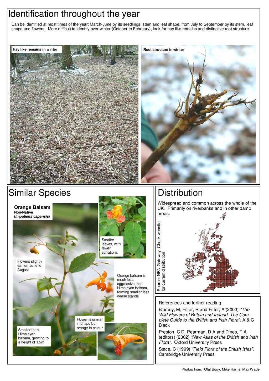
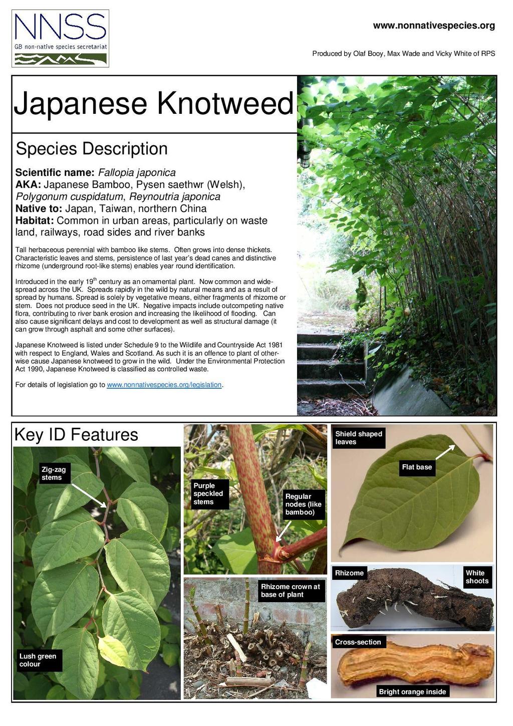
8 Appendix E - Species Identification This appendix links to the species Identification guides supplied via the NNSS ( which are distributed at any relevant LRT meetings and events. Included are those for the three priority species. The aim of providing this information is so that the public and our network of volunteers can easily identify these species and report back to the Trust and these sightings can be added to our database. Other species are available via the NNSS website and will be included in this report as seen fit. Species included: Himalayan Balsam Giant Hogweed Japanese Knotweed
9
10

11

12
13

14
15 Appendix F - Species Distribution This information has been amalgamated from a variety of sources, both Trust surveys and also volunteer surveys to give a better overview of the INNS problem. The maps shown use blue to show the location of Himalayan Balsam and red to show Japanese Knotweed. Himalayan Balsam Japanese Knotweed Giant Hogweed Other sightings
16 Appendix G - Species Control methods & Calendar of control times All information has been collected by the Ribble Rivers Trust in Himalayan Balsam Action Target Notes Rationale Surveying Himalayan balsam on un-surveyed watercourses Habitat restoration of treated areas Re-survey of treated areas and follow up control Surveying is most effective in the summer months; however this time is best spent on control work. It is possible to survey at any time of year. Local origin native wildflower seed can be sown on areas lacking in vegetation or flowers due to balsam removal. In riparian sites it may be possible to do a habitat scheme comprising fencing and tree planting. All treated areas need to be revisited a number of times throughout the summer to check the effectiveness of control and carry out any further work needed. A record of the area covered by the survey and areas with no balsam should be kept. The majority of the major tributaries in the catchment are now surveyed, and the priority streams have been identified. However, a better understanding of the distribution of Himalayan balsam would help inform the management strategy for future years. Records of the survey route are useful for planning future surveys. Absence data is useful for determining the true species distribution and is particularly useful for locations with old records of the species. Removal of Himalayan balsam can leave large areas of bare earth which may lead to erosion and promote re-colonisation by invasive species. It also deprives local insects of a major pollen source. Suitable habitat restoration, for example by planting wild flowers can help mitigate these effects. Grazing helps keep balsam under control so stock exclusion and tree planting more appropriate on sites cleared of Himalayan balsam. The first treatment is rarely 100% effective, especially in dense or extensive patches. Re-surveying the area a few weeks after treatment will give an indication of the survival rate. Follow up control of any regrowth can be carried out at the same time. Spray suitable sites with glyphosate-based herbicide Suitable sites will be densely colonised with balsam and have low native plant diversity. Ideally away from water and low gradient terrain. May to July is the most effective time. Glyphosate is the most effective approved herbicide for this plant. Spraying is a labour efficient way of treating dense infestations but care must be taken to reduce damage to native flora. Environment Agency permit required if spraying near water.
17 Spray grassland sites with 2,4-D amine-based herbicide Strimming (Brushcutting) of plants in accessible areas Controlling plants by hand, by pulling and using grass slashers Suitable sites will have abundant balsam growing amongst grass, with few other native broad-leafed plants. April and May is the best time. Most habitats types are suitable for using a strimmer to clear the balsam. A metal brushcutter head is useful for cutting through thicker vegetation. April to September Suitable for sites with difficult terrain, by watercourses, with low densities of balsam and environmentally or ecologically sensitive habitat. April to September. 2,4-D amine is a selective herbicide which only kills broad-leafed plants, without harming grasses. This is particularly useful for balsam control in grassland as it leaves the sward intact and protects the underlying soil. EA permit required if spraying near water. Strimming is an effective way to control Himalayan balsam, particularly when it is growing densely. It avoids the need to use herbicide so can be more appropriate by watercourses and on other sensitive sites. The lower the balsam can be cut, the better; below the first stem node is ideal. Can be useful as a pre-treatment for other forms of control. Hand pulling is a labour intensive but effective control method. It is highly selective so reduces damage to non-target species to a minimum. Grass slashers are useful hand tools which can be very effective at cutting large numbers of plants. Must be carried out during the growing season but before flowering. Lessons learned from 2012 In sites with high densities of Himalayan balsam, hand pulling as the only method of control can be prohibitively time consuming. A better management strategy would be to start with strimming and/or spraying treatments and follow up with hand pulling later in the season. Contrary to some literature, Himalayan balsam does not flower or set seed synchronously. Late developing plants continue to flower through to the end of September. Some of these late plants flower when only a few inches tall though it isn t known if these would successfully set seed. To ensure full control of each site, repeat visits are required throughout the growing season at regular intervals to prevent seed being set. Japanese Knotweed Action Target Notes Rationale Cutting of dead knotweed stems A brushcutter or machete can be used for this task. Cut material can be left on site. Between late November and March the stems are dead and will not re-root so there is no risk of spreading the knotweed by cutting the stems. Knotweed stems die back in winter but can still be a significant obstruction the next year when the new growth needs spraying. Clearing the old stems during the winter will much improve access for spraying meaning that the application is more effective.
18 Spraying with glyphosatebased herbicide Survey new records of knotweed and assess for impact and treatment options Habitat restoration of treated areas Re-survey of treated areas and follow up control Monitor arrival and effects of psyllid Aphalara itadori Each site should be sprayed at least twice per year. Ideally, spray each time the regrowth reaches about 1 m tall and once in autumn just after flowering. The first application is usually in May. Important information to record is the size of the colony, how dense it is and how far it is from water. Areas of bare earth around and under the Japanese knotweed can be temporarily restored through the use of wildflower and grass seeds. These can be sown after the last treatment each year. Resurvey should look for the effectiveness of the treatment and whether any patches have been missed. Further herbicide applications may be needed. Check plants for psyllid before treatment. If suspected psyllid is found, delay treatment until identification is confirmed. Glyphosate is the most effective approved herbicide for this plant. Spraying is a labour efficient way of treating dense infestations but full control can take several years to achieve. Care should be taken to reduce damage to native flora but there is usually little else growing underneath Japanese knotweed. An EA permit is required to spray near water. Speculative surveys for knotweed are not usually an efficient use of time. Knotweed tends to be localised and does not cover large areas. New records of knotweed need to be resurveyed, firstly to assess the need to control and secondly to record the information needed to plan control work. Removal of knotweed can leave patches of bare earth which may lead to erosion and promote colonisation by Himalayan balsam. Suitable habitat restoration which encourages development of native vegetation cover can stabilise the soil and discourage further invasion. The difficulty is that knotweed takes several years to treat and that each treatment is likely to kill many of the plants underneath the knotweed. Japanese knotweed control requires several years of persistent treatment to fully kill the plants. Re-survey, follow up control and monitoring are essential to ensure full control and prevent a waste of time and money. This insect was released by CABI in March 2010 under license from Defra as a biocontrol agent for Japanese knotweed. As a new species and a new control agent, it is important to monitor for presence of the psyllid in the Ribble catchment and if found, inform CABI and seek advice regarding further management. Lessons learned from 2012 It is difficult to effectively spray colonies of knotweed that are tall and dense. Only the outside edge of these colonises really gets sprayed. Knotweed should be sprayed when it is a manageable height in spring so that it does not grow too tall to spray later in the year.
19 Stem injection is very time consuming and only works for knotweed with thick stems. This technique can be useful for small patches of knotweed on sensitive sites where herbicide may cause damage, however for the majority of sites, knapsack spraying is more appropriate. Giant Hogweed Action Timing Target & Seasonality Rationale Glyphosate treatment of April - June high priority sites Prevention of flowering by mechanical means Survey new records of giant hogweed and assess for impact and treatment options May - August June - November Leaves of giant hogweed are most permeable to glyphosate when they are young so the best time to spray is spring and early summer, before flowering. Plants can be cut or dug up just below ground level. This may prevent or delay flowering but may need to be repeated. As a last resort, the flower stalk itself can be cut and removed. Important information to record is the abundance or number of plants, the size of the plants and the distance from a watercourse. Glyphosate is the most effective approved herbicide for this plant. Spraying using a knapsack sprayer with a lance reduces the risk of skin contact with the plant. Spraying personal protective equipment also protects against contact with the plant. Preventing flowering of the plant prevents seed production. If chemical treatment is not possible in a particular season, this is the next best option. This method of treatment also weakens the plant and reduces the need for herbicide use. Giant hogweed is a hazard to health and new records should be assessed promptly for risk posed to the public. Rapid response to new records of giant hogweed may prevent establishment of a colony and be cost effective in the long term. Habitat restoration July - November Habitat restoration carried out where appropriate Re-survey of treated areas and follow up control June - September Resurvey of treated sites should look for the efficacy of treatment and any plants missed. Follow up control should then aim to achieve full control of the site for that year. Removal of giant hogweed, especially by mechanical means can leave areas of bare earth which may be susceptible to erosion or colonisation by invasive plants. Habitat restoration, for example by planting native wildflowers can help mitigate these effects. Wildflower mixes should be of local origin and suitable for the given habitat. Glyphosate treatment of giant hogweed may require several applications to kill the plant. In subsequent years, new plants are likely to emerge from the seed bank. Re-survey, follow up control and monitoring are essential to ensure full control.
20 Lessons Learned from 2012 Cutting giant hogweed down at ground level in May is insufficient to prevent flowering in all plants. Repeat treatment closer to flowering time in June or July is necessary. Their long lifespan and seed dormancy means they can be persistent in a location over many years, even if control has been carried out in the past.

21