DEVELOPMENT OF PORTABLE SOIL INFORMATION SYSTEM AND ITS FUTURE USE IN NIIGATA PREFECTURE, JAPAN
|
|
|
- Bruce Newton
- 5 years ago
- Views:
Transcription
1 DEVELOPMENT OF PORTABLE SOIL INFORMATION SYSTEM AND ITS FUTURE USE IN NIIGATA PREFECTURE, JAPAN Toshimitsu Honma Niigata Agricultural Research Institute 840 Nagakurachou, Nagaoka, Niigata , Japan ABSTRACT Soil plays a vital role in crop production. Today, soil information obtained through long-term soil monitoring is not only a basis for crop suitability and soil fertility, but also for advanced land use, environmentally sound agriculture, and farm land development. In Japan, many soil survey projects were launched in the 1950s. As a result, assessment of arable soils revealed the status and problems of soils and consequent measures for amendment succeeded soil productivity improvement. Recently, however, the number of soil monitoring sites has declined conspicuously for several reasons. Continuous soil monitoring is necessary to identify the present soil conditions and to predict change in soil conditions by different soil management practices. Geographic Information System (GIS) is a promising tool to maximize the utilization of a number of soil information. This paper introduces the soil survey and monitoring activity in Niigata prefecture and its outcomes. Furthermore, it presents a new soil survey style with the use of Personal Digital Assistant (PDA) and future prospects for the utilization of soil data in Niigata prefecture. Key words: portable soil information system, GIS, PDA, soil monitoring, Niigata INTRODUCTION In Japan, the national soil information database was developed using the data obtained from the Fundamental Soil Survey for Soil Fertility Conservation, and the Basic Soil-Environment Monitoring Project (Stationary Monitoring) conducted by the Ministry of Agriculture, Forestry and Fisheries (MAFF). Using this information, detailed soil maps were produced in every prefecture and some of the progressive applications were reported. In Chiba prefecture, an integrated GIS composed of digital soil map and soil attribution was developed and it provided several web-based thematic maps such as the CEC map (Yamaki 2001). Mie prefecture developed Mie Agriculture Soil Information System (MASIS), which was composed of the Mie prefecture Geographic Information System (M-GIS) and the digital soil map. This system was able to display the soil map and soil properties and search soil survey data. However, this system was accessible only to the people who live in Mie prefecture (Murakami et. al. 2001). In Niigata prefecture, the soil map for potential decomposability classification of organic matter had been produced by spatial analysis technique, using soil properties, precipitation data, and land use classification and so on. However, the soil surveys for these digital soil maps were conducted about years ago. Due to land use changes, the shape of soil region had changed. It is necessary to update the polygon data and soil information. Nakai (2005) had developed the Soil Resource Inventory (SRI), which was able to update the soil information through web. Initially, it was open to the public, but now, it is not available due to security issues. USE OF SOIL DATA FOR FARMING MANAGEMENT IN NIIGATA PREFECTURE Present Status of Soil Survey Fundamental Soil Survey for Soil Fertility Conservation. To identify limiting factors of production efficiency and soil amendment, a soil survey had been carried out at each 25-ha of arable land for 17 years ( ) in Niigata prefecture. This survey showed that arable land in Niigata prefecture was classified into 13 soil groups, 40 soil series groups, and 108 soil series. The main limiting factor for production efficiency in paddy was the 1
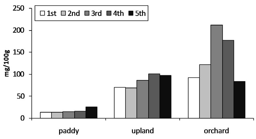
2 difficulty of plowing and the potential ability of oxidation-reduction mainly because of the fine textured heavy soil. The application of silicic acid amendments and subsurface drainage were used as countermeasures for these limiting factors as noted in Report on Fundamental Soil Survey for Soil Fertility Conservation. Finally, the map for Soil Productivity Capability Classification and the map for Countermeasure of Maintenance of Farmland Fertility were produced (Niigata Pref., 1978). Basic Soil-Environment Monitoring Project (Stationary Monitoring). Soil profile description was carried out every 5 years for 20 years ( ) in Niigata prefecture. The effects of soil management, such as the application of fertilizer, soil amendments and organic matter in several soil types, on changes of soil psycho-chemical properties (mainly in top soil) were examined by interviewing farmers. From 1979 to 1998, there were about 500 stationary survey sites in Niigata prefecture. After 1998, there were about 100 sites, because of more detailed soil survey for selected major soils (Table 1). Changes in Soil Psycho-chemical Properties in Arable Land in Niigata Prefecture Figs. 1-8 showed the changes in psycho-chemical properties (plow layer) of several land uses in the past 25 years, using statistics from the Basic Soil -Environment Monitoring Project (Stationary Monitoring). In paddy, soil compactness declined and total carbon content did not change (Figs. 2-3). However, a decrease in exchangeable magnesium and an increase in exchangeable potassium caused a decrease in the MgO/K 2 O ratio (Figs. 4-6). Available nitrogen and phosphate increased slightly (Figs. 7-8). No trends or changes were recognized in upland and orchard because of large fluctuations among the surveys. However, available nitrogen and phosphate increase were similar to those of paddy. A primary factor for these changes in soil properties, especially in paddy, was the effect of increased rice straw and phosphate application to the soil (Honma 2007). Table 1. Number of soil survey sites in Niigata prefecture* Soil group 1st 2nd 3rd 4th 5th 6th Total ( ) ( ) ( ) ( ) ( ) ( ) 2 Paddy Gley lowland soils Gray lowland soils Wet andosols Gley upland soils Gleyed andosols Brown lowland soils Gray upland soils Upland Andosols Brown lowland soils Sand-dune regosols Brown forest soils Gray lowland soils Gleyed andosols Orchard Brown lowland soils Sand-dune Regosols Andosols Yellow soils Gray lowland soils Brown forest soils Total *Basic Soil-Environment Monitoring Project.


3 Fig. 1. Changes of compactness. Fig. 2. Changes of Total Carbon. Fig. 3. Changes of ex. CaO. Fig. 4. Changes of ex. MgO. Fig. 5. Changes of ex. K 2 O. Fig. 6. Changes of ratio of ex. MgO/ex. K 2 O. Fig. 7. Changes of available nitrogen. Fig. 8. Changes of Truorg phosphate. 3
 through the local Agricultural")
4 Use of the Soil Survey Data Recommendations for Land Management. Recommendations were submitted every five years and these can be compared to previous recommendations. Based on the soil survey data, an interview result about soil management, and soil psycho-chemical properties, the Niigata Agricultural Research Institute (NARI) through the local Agricultural Development Center submits recommendations for each soil series. Report to the Prefecture Administration. All information was provided to the prefectural office. The office could recognize the yearly changes in arable land from the soil survey data. For example, the effects of the application of rice straw into the soil and the rotation of irrigated paddy rice and upland crop on soil carbon content in fine textured gley lowland paddy soil were significant. By sharing the data from the soil survey, the office could issue soil management guideline and obtain new ideas such as setting the trial standards for application of rice straw in paddy soils. Recent Outcomes i) Digital Soil Map. Basically, the digital soil map was composed of the Arable Soil Map in Niigata Prefecture (1983) combined with the soil properties found in the Fundamental Soil Survey for Soil Fertility Conservation which averaged every soil series in Niigata prefecture. Soil classification data (soil group, soil series group, soil series) and soil properties (area, depth of plow layer, texture, balk density, solid ratio, CEC, phosphate absorption coefficient, total carbon, total nitrogen, exchangeable cations, calcium saturation ration, ph, exchangeable acidity) were included in the digital soil map. Today, in Niigata prefecture, the digital soil map has been distributed to several Agricultural Development Centers with viewer software (Arc Explore, Esri. Corp.) and has been used for technical advice (Figs. 9 & 10). ii) Map for Ability of Decomposition of Organic Matter. Recently, organic wastes like animal manure and sewage sludge compost have been applied to arable land to maintain soil fertility. In Niigata prefecture, the amount of organic waste was estimated at 3,358,200 t/year (Niigata pref., 2004), and their application to farmlands become important because of the high fertilizer price. The ability of decomposition of organic matter in arable land was assessed based on five factors. A map for the ability of decomposition of organic matter was produced using this assessment. The five factors included air temperature, precipitation, soil texture, land slope and land use. The factors, except air temperature, were quantified by categorization. These points were substituted for the following formula for evaluation (Tables 2 & 3). Figure 11 shows a part of map classified into Nothing to Strong. Additionally, these methods for evaluation were quoted from Evaluation for ability of decomposition of organic waste (Sugahara and Inoko 1987). iii) Analysis of Total Carbon Content in Arable Land. Based on the Basic Soil-Environment Monitoring Project (Stationary Monitoring), changes in total carbon content of lowland paddy soil (plow layer) in Niigata prefecture for the past Fig. 9. Digital soil map (example). 4
 2000mm< 3 HC 0 Soil texture LiC,SiC,SC 1 (ST) CL,SiCL,SCL 2 L,SiL,SL 3 S 4 8-15 1 Slope 3-8 2 (S) 0-3 4 Land use")
5 Table 2. Point of several category Factor Category Point <1000mm 1 Rainfall mm 2 (R) 2000mm< 3 HC 0 Soil texture LiC,SiC,SC 1 (ST) CL,SiCL,SCL 2 L,SiL,SL 3 S Slope (S) Land use Poorly drained paddy 0 (Lu) Well drained paddy 2 Upland, orchard 4 Fig. 10. Soil properties (example). Table 3. Evaluation for ability of decomposition of organic matter* Grade Avility D-value I Strong 240< II Slightly strong III Normal IV Weak V Nothing <20 D** = (T***+R+ST)*S*Lu * Quotation from Evaluation for ability of decomposition of organic waste (Sugahara and Inoko 1987). ** Ability of decomposition of organic matter. *** Averaged air temperature. 25 years were analyzed and the following results were noted (numbers of investigated sites are Gley Lowland soil: 1112, Gray Lowland soil: 259): No changes in total carbon content was recognized for the past 25 years (Fig. 12). Total carbon content in Gray Lowland soil was lower than that of Gley Lowland soil, and was lower toward subsoil. This suggests that the decrease of carbon content in subsoil was due to implementation of subsurface drainage (Fig. 13). Total carbon content of paddy soil, which had experienced irrigated paddy rice and upland crop rotation in the past five years, was lower than that without rotational cropping. Thus, irrigated paddy rice and upland crop rotation might provoke decrease in carbon content in paddy soil (Table 4). Carbon content of plow layer was the same or increased by the application of rice straw (Table 5). Regarding the total carbon content in gleyed paddy soil at the depth of 30 cm, a trail calculation using bulk density and layer depth found that the amount of total carbon content in Niigata prefecture was about 7.68 megatons. Problems Some problems were pointed out regarding the soil survey system and the use of data. On the soil survey system, it became difficult to evaluate the actual state of every soil type of the cultivated land areas in Niigata prefecture because the numbers of the soil survey sites provided by farmers decreased. More than 100 soil survey sites were investigated yearly ten years ago, but only 30 soil survey sites exist nowadays. This has been an issue not only in Niigata prefecture but also throughout the country. The main reasons for the decline in the monitoring sites are the decreasing number of surveyors and the budget constraint. As such, maintaining the accuracy of the soil survey has become a challenge. 5


6 Fig. 11. Map for ability of decomposition of organic matter. Fig. 12. Changes of total carbon of several soil types. Fig. 13. Total carbon content of several soil types. 6
7 Table. 4. Effect of paddy-upland rotation in the past five years on T-C content of plow layer in several soil type* Soil type History Brown Lowland Gray lowland Gley lowland No-rotation 2.42% (22)*** 1.95% (219) 2.99% (1013) Rotation 1.15% (17) 1.81% (40) 2.67% (109) t-test** ** n.s. ** * Basic Soil-Environment Monitoring Project. ** Significantly different at p<0.01 *** Number of survey sites Table. 5. Effect of application of rice straw on changes of T-C content of plow layer Gray lowland Gley lowland No-application Application No-application Application 1st 1.84% 1.88% 3.10% 3.04% ( ) 4th survey 1.74% 2.10% 2.81% 3.03% ( ) 4th/1st These facts showed how to maintain the carbon content in soil by soil management. Practically speaking, the data utilization has been limited. Unfortunately there has been inadequate follow up by the researchers to see if the recommendations are adopted and whether or not they have any impact. Changes in the application of organic matter and soil amendments, depth of the plow layer and lowering groundwater level due to farmland development has caused changes in the soil environment. Failure to understand the actual soil condition means difficulty in maintaining soil fertility and in disseminating environmentally sound agriculture practices. Moreover, climate changes in recent years are considered to have affected the soil moisture, mineralization of nitrogen and carbon stock. Therefore, it is important to recruit and train new soil surveyors and maintain the Stationary Monitoring Survey to better understand the actual soil condition. DEVELOPMENT OF PORTABLE SOIL INFORMATION SYSTEM With GIS, it has become possible to analyze soil data, which has the spatial information. GIS. Simulated information from the data of the GIS has been used to combine the soil survey data. Including Niigata prefecture, many other prefectures have been updating old soil maps using the GIS. Using these new systems, land application potential for organic matter can be mapped out by analyzing the simulated information data of soil texture, precipitation, inclination, and so forth. However, updating the data with the recent soil conditions has been a problem because the number of soil monitoring sites decreases. Additionally, with the difficulty in obtaining support from the Agricultural Development Center, the efficiency of the soil survey system has to be increased and the use of soil survey data has to be maximized. To solve these problems, the Portable Soil Information System (PSIS) has been developed in Niigata prefecture. PSIS was developed to improve the efficiency and analysis of the soil survey by combining the simulated data and the survey data. For system specifications, a customized Arc Pad6.0 with PDA with Windows Mobile with OS for soil survey was installed. Global Positioning System (GPS) is installed as well. Since the digital soil map of Niigata prefecture was stored in PSIS, it was able to update polygon, update the properties on 7


, compactness, moisture condition, mottling (abundance, nature, shape, contrast), gleyzation, peat (grade of decomposition, nature) and porosity (abundance, size).")
 FUTURE USE OF THE PORTABLE SOIL INFORMATION SYSTEM Horizon Compactness & moisture condition Basic information Horizon boundary & texture Porosity The author has been studying the effective use of")

8 the soil map using the soil survey data, and make assumptions of the soil data of the survey sites beforehand. First, at the soil monitoring sites, information such as site numbers, farmer s name, address, land category and the cultivated crop were inputted using select dialogs. Then, the soil horizon was decided and soil properties such as soil texture, color, gravel, mottle and gley reaction were selected. GPS would automatically take spatial information. Then, information on soil management practices such as plowing, crop rotation, application of organic matter were inputted into notes. After the soil survey, data acquired using PSIS would be synchronized to the soil data in the desktop PC automatically by cradle. Table 6 shows information inputted to the PDA. Basic information of the survey point was as follows: profile number, land use, latitude, and longitude, day of description, cultivator and crop name. Soil information was as follows: horizon, horizon boundary, texture, gravel (abundance, shape, stake of weathering, size), soil color (hue, value, chroma), organic matter content, structure (type, grade, size), compactness, moisture condition, mottling (abundance, nature, shape, contrast), gleyzation, peat (grade of decomposition, nature) and porosity (abundance, size). Much of the information could be selected from the List Box for saving input work (Fig. 14) FUTURE USE OF THE PORTABLE SOIL INFORMATION SYSTEM Horizon Compactness & moisture condition Basic information Horizon boundary & texture Porosity The author has been studying the effective use of soil information obtained by PSIS at soil survey. Preparation of recommendations for farmers, reports to the prefectural administration, and producing new thematic maps using the features of GIS with the accumulated data have been discussed. A number of GIS data regarding the national agricultural production infrastructure has been gathered. For instance, MAFF has been implementing MIDORI (water, soils, and rural area) information utilization project for five years. The base map of agricultural- rural infrastructure is produced at the scale of 1:2,500. By overlaying the attributed data from PSIS on this map, updated attributed data per plot could be added. Further, MAFF has been conducting an extensive survey to obtain the crop situation index of rice every year. In Niigata prefecture, a detailed survey about variety, Fig. 14. Picture of inputting the information. 8
9 Table 6. Input information of Portable Soil Information System Input information Detail Horizon 1,2,3,4,5,6 Layer depth Horizon boundary Texture Input directly Abrupt, Clear, Gradual, Diffuse HC,SC,LiC,SiC,SCL,CL,SiCL,SL,L,SiL,LS,S,Gravel Gravel Abundance None, Few, Common, Many, Abundant, Dominant Shape Rounded, Subrounded, Angular State of weathering Fresh, Slightly weathered, Weathered, Strongly weathered Size Fine gravel, Gravel, Stone, Large stone Soil color Hue-1 2.5,5,7.5,10 Hue-2 YR,Y,GY,G,BG Value 2,3,4,5,6,7,8 Chroma 1,2,3,4,5,6,7,8,0 Organic matter Content Low, Medium, High, Very high, Organic layer Structure Type Platy, Prismlike, Subangular blocky, Angular blocky, Granular, Single grain Massive Grade Weak, Moderate, Strong Size Very fine, Fine, Medium, Coarse, Very coarse Compactness Input directly Moisture condition Wetness Dry, Moderately dry, Moist, Wet Mottling-1 Abundance None, Few, Common, Many, Abundant Nature Iron, Mangan, Other Shape Threadlike, Root-like, Filmy, Tubular, Speckled, Cloudy, Irregular Contrast Faint, Distinct, Prominent Mottling-2 Abundance None, Few, Common, Many, Abundant Nature Iron, Mangan, Other Shape Threadlike, Root-like, Filmy, Tubular, Speckled, Cloudy, Irregular Contrast Faint, Distinct, Prominent Gleyzation Dipyridyl reaction -,+-,+,++,+++ Peat.Muck Grade of decomposition Weak, Moderate, Strong, Muck Nature Low-moor peat, Transitional-moor peat, High-moor peat Porosity Abundance None, Few, Common, Many Size Very fine, Fine, Medium, Coarse sowing time, planting time, harvest time, yield, yield component, and lodging rate for about five hundred plots has been conducted. Fig. 15 shows the rice yield (Oryza sativa L. cv. Koshihikari). Of course, geographic information was attached to this survey. However, at this point, the survey data was not widely utilized except in calculating the crop situation index. Thus, it was possible to know the correlation between soil data and rice yield using the data of the detailed survey and rice yield. Additionally, other uses could be expected by adding data or applications other than the soil survey to the PSIS. For example, growth data of rice cultivation (plant length, tiller number, measurement of chlorophyll meter) at the intervals of about ten days could be inputted into PSIS in real time, then growth information related to soil information could be obtained. Then a proper quantity and timing of topdressing at the panicle formation stage could be determined, helping make an accurate estimate of growth and nitrogen mineralization for Koshihikari, which was very sensitive to the effects of fertilizer. Moreover, it is possible to deal with natural calamities such as typhoons and earthquakes by inputting the state of damage (flooded field, broken field, storm damage and death by sea breeze) in the affected area. In the not-too-distant future, there will be a Field Management Information System using Mobile GIS (Fig. 16). 9
10 Fig. 15. Map of yield of rice (Koshihikari 2007). Field Management Information System using Mobile GIS Development of mobile-gis device for agricultural researcher Integration with growth info., weather info. and field management Investigation of natural calamities Investigation of product process Acquire the growth data Display the technical information Factor analysis to growth, yield and quality Rapid response to natural calamities Traceability of production Fig. 16. Future plan. CONCLUSION Maximizing use of soil information requires GIS technologies. More importantly, GIS plays a significant role in analyzing detailed soil information and integrating it with growth information, weather information, and field management. Thus, strengthening soil monitoring survey system and capability building are necessary. ACKNOWLEDGMENT The author would like to acknowledge Mr. Kazuhide Kumagawa, Pasco Co. Ltd., for the development of the Portable Soil Information System. The author would also like to express his gratitude to Prof. Takuji Ohyama, Niigata University, Japan, for his helpful suggestions. Likewise, he extends his appreciation to the staff of the Niigata Agricultural Research Institute for the soil survey and soil analysis. 10
11 REFERENCES Honma, T Agriculture, Soil Science and Plant Nutrition in Niigata Prefecture. Jpn. J. Soil Sci. Plant Nutr. 79: (in Japanese). Murakami, K., N. Yasuda, H. Izuoka, and T. Takeuchi GIS-Based Soil Information System of Arable Land in Mie Prefecture. Jpn. J. Soil Sci. Plant Nutr. 77: (in Japanese). Nakai. M., National soil resources inventory system. Jpn. J. Agri. Tech (in Japanese). Natl. Inst. Agro-Environ. Sci Report of environmental conservation and maintenance function on national resources of agriculture, forestry and fisheries. 2: (in Japanese) Niigata Pref Report of So-il Survey for Maintenance of Farmland Fertility (in Japanese). Niigata Pref norinsyokutomidori/gyosei/vision/bumon/ biomass/images/biomass_sankou.pdf (in Japanese) Yamaki, A Soil information system obtainable from personal computer through internet. Jpn. J. Soil Sci. Plant Nutr. 72: (in Japanese). 11