Collaboration of Space Research Institute NASU-SSAU with EC JRC on satellite monitoring for food security: background and prospects
|
|
|
- Meghan Wilcox
- 5 years ago
- Views:
Transcription


1 Collaboration of Space Research Institute NASU-SSAU with EC JRC on satellite monitoring for food security: background and prospects Prof. Nataliia Kussul 1 Space Research Institute NASU-SSAU, Ukraine


2 Context of cooperation - GEO related projects GEOGLAM GEO GLobal Agricultural Monitoring Initiative JECAM Joint Experiment on Crop Assessment and Monitoring SIGMA SIGMA FP7 Project Stimulating Innovation for Global Monitoring of Agriculture ERA-PLANET Horizon 2020 project on European Research Area in Earth Observations
. Centroid: lat: 50.35 N, long: 30.71 E Intensive agriculture area.")


3 JECAM-Ukraine site description Location: Ukraine (Kyiv oblast with area 28,000 km 2 ; intensive observation sub-site of 25x15 km 2 ). Centroid: lat: N, long: E Intensive agriculture area. Main crop types: winter wheat, winter rapeseed, spring barley, maize, soybeans, sunflower, sugar beet, and vegetables Field size: from 30 to 250 ha Crop calendar: Winter: September July; Summer: April October Cloud coverage can be very frequent during the growing season Topography: mostly flat, slope: 0% to 2% Soils: different kinds of chernozems Soil drainage is ranging from poor to welldrained. Irrigation infrastructure is limited 10 km 3 km Kyiv oblast & Vasylkiv district Climate and weather: humid continental Map of intensive observation sub-site


4 Main directions of cooperation with JRC Crop classification & area assessment Biophysical parameters estimation Crop yield forecasting


 Crop field")


5 % oats in ground survey Contract no Crop area estimation with satellite images in Ukraine Coordinator from JRC : J.F. Gallego Satellite data Ground data Processing Orthorectification Segmentation Classification Along the road survey Stratified Area Frame Sampling LC map Area estimates (pixel counting) Crop field boundaries Segments Satellite data: MODIS AWiFS Landsat-5/TM LISS-III RapidEye Data fusion Adjustment of area estimates (Regression estimator) Final results Area estimates Accuracy assessment % pixels classified as cereals Efficiency of satellite data use for crop estimation: Price is 1.5 lover Area frame sampling (segments) and along the road surveys (curves)


 or row (centre)")
6 Project Evaluation of the coherence between Copernicus products and crop biophysical parameters Evaluation of the relationship between the crop biophysical parameters measured on field with or vegetation indices extracted from high resolution sensors; and an assessment of the uncertainties of low-resolution (1 km) biophysical products from Copernicus program. LAI=0.22 fcover=16% ALA=16º DHP imagery samples Results of processing with CAN-EYE VALERI sampling strategies for random (left) or row (centre) and regularly planted vegetation (right). 6
7 Project Evaluation of the coherence between Copernicus products and crop biophysical parameters Sample fields location Modelled on Landsat 8 and ground data MODIS MOD15A2 product SPOT-VGT Copernicus product 7


8 Project Parcel based classification for Agricultural Mapping and Monitoring (Ukraine) Joint experiment on parcel-based classification for agricultural mapping and monitoring in Ukraine. Study area - Kiev Oblast (JECAM test site in Ukraine). Methods of Classification and data: Proba-V and Sentinel-1/SAR, Landsat-8; neural network based classifier (SRI); multiple classifiers available in Google Earth Engine (GEE); Estimate advantages of the GEE cloud platform to efficiently process and classify large volume of remote sensing data, and as such enabling classification over large territories. Results of CART, GEE 8
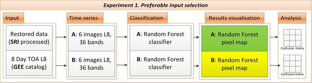


9 Data processing workflow A B

")

10 Multi mission crop classification (2015) Satellite data: 4 Landsat-8 scenes 15 Sentinel-1 scenes Ground data: 547 ground samples (train and test sets) KYIV OBLAST (2015) Satellite OA, % pixel based L-8 + S SENTINEL LANDSAT
 A")


11 Filtration results (Kyiv oblast) A majority voting scheme Pixel-based classification map Method that divides parcel into the fields
 Meteorological observations:")
; Density of crops (phase dependent); Damage by pests and")

12 MARS approach in Ukraine (Ukr Hydrometcenter) Adopted for Ukraine Weather CGMS stations system location (since 2011) Meteorological observations: Plant phenology - daily; Assessment of the state of the crops - daily; Plant height (daily); Density of crops (phase dependent); Damage by pests and diseases; A crops survey over large areas; Monitoring of wintering conditions crops - daily; Determination of the available moisture in the soil (1 per decade) 12


13 Crop yield forecasting: towards Monitoring Agricultural ResourceS (MARS) Providing products since 2011 for Ukraine: ESA GLOBCOVER cropland, 300 m, 2008; MODIS MOD13Q1 NDVI; Statistical data from State Statistics Service of Ukraine; Up to 2 months before harvest NDVI FAPAR RMSE average RMSE average Operational forecasting
14 Challenges and further steps Dedicated Program in NASU to support national priorities and cooperation with JRC; Implementation of MARS program for crop yield forecasting in Ukraine; GEOGLAM-Ukraine program in line with GEO strategic plan to provide applied scientific results of satellite crop monitoring to Ministry of Agriculture 14
15 Thank you! 15