Part 1: Master Plan Study CHAPTER 2 THE STUDY AREA
|
|
|
- Kerry Ray
- 5 years ago
- Views:
Transcription
1 Small Scale Agricultural & Rural Development Program along the Mekong River Final Report Part 1: Master Plan Study CHAPTER 2 THE STUDY AREA
2 CHAPTER 2 THE STUDY AREA 2.1 Physical Conditions Location and Area (1) Location Lao PDR is a landlocked country that covers 236,800km 2 and is bordered by Burma, Cambodia, China, Thailand and Vietnam. Its geographical location has subjected it to the influence of its neighboring countries, both in times of peace and turbulence. Migration and regional conflicts have also contributed to the geographic distribution and diversity of the ethnic groups of present time. These characteristics are evident in the study area. The study area extends over the 3 provinces located in the south of Vientiane Municipality or in the southern panhandle of the country and includes, both high mountains and level areas along the banks of Mekong (See Location Map). Accessibility to the study area by the national trunk road (Route 13) is easy and good, except for the stretch leading from Savanakhet to Saravan where construction work is in progress. The districts in the mountainous regions, however, are less advantageous and less accessible, especially during the wet season when laterite-paved provincial and graded rural roads become worse. (2) Area The study area covers 12 districts in 3 provinces, Bolikhamsai, Khammouane and Savanakhet, with an area up to 14,811km 2. The land area of each district and province are shown below. Except for Bolikhan and Sebangfai district (2 and 8 in Location Map), all other districts in the study area are considered the riparians of the Mekong. Land Area of the Districts in the Study Area Province District Bolikhamsai 6,079 km 2 Thaphabath 1,212km 2 Bolikhan 1,803km 2 Paksan 654km 2 Khammouane Hinboun Thakhek Nongbok 5,216 km 2 3,011km 2 918km 2 321km 2 Savanakhet Xaibouri Khanthabouri Xayphouthong 3,516 km 2 1,110km 2 521km 2 512km 2 Pakkading 2,410km 2 Sebangfai 966km 2 Songkhon 1,373km Topography The eastern side of the study area is mainly mountainous, with an elevation above 500m. It is characterized by steep terrain, short and narrow valleys having a relatively low agricultural potential. A large area of Khammouane province and eastern part of I - 7
3 Bolikhamsai and Savanakhet are limestone mountains and crystalline rocks. The western border of the study area is demarcated by the Mekong River. The stretch of Mekong between the river mouth of Nam Mang and Sebanghiang is about 400km. Together with its tributaries that originate in the eastern mountains and flow westwards into the Mekong, the Mekong is an important artery for transportation along its entire length until the Khong Falls at the southern border. Likewise, it is considered as the main water resource in the area. The alluvial plain and terraces along the Mekong and its tributaries cover about 20% of the study area and are suited for extensive paddy cultivation and livestock raising. The eastern mountainous border with Vietnam is sparsely populated by the tribal minorities and has served as a physical barrier. Trans-border transport is only possible through a few roads such as Route 8 and 12 branching off from Route 13. The three major plains in the study are known to be the rice bowls of the country. The Bolikhamsai plain, m MSL and about 200km long and 5 50km wide, is like a corridor of Route 13 and located along the Mekong from the mouth of Nam Ngum to Nam Kading. The Sebangfai plain is quite flat, covering both sides of the Sebangfai river starting from the highway-bridge of Route 13 and ends at the confluence point with the Mekong. The Sebanghiang plain, m MSL and about 100km long and 60km wide, starts at the Xenoy river mouth and ends at Kengkok of the Xechamphone river. Due to the very flat topography, the Sebanghiang and the major tributaries wind and meander through the basin. However, most of the Sebanghiang plain is outside of the study area Meteorology and Hydrology (1) Meteorology The climate of Lao PDR is basically tropical monsoonal, with distinct wet season from May through October, a cool dry season from November through February and a hot dry season in March and April. The climate of the study area, comprising a large part of the country along the lower Mekong, is strongly influenced by the tropical monsoons with distinctly marked wet and dry season intervened by short period of transitional instability. The wet season is characterized by frequent heavy rainfall brought by moisture-laden air of the Southwest Monsoon, lasts from May to October. About 75 80% of the annual rainfall occurs in the wet season with the peak in June August. The dry season, is influenced by relatively drier and cooler Northeast Monsoon that lasts from December April. (a) General Climatic Features Except for rainfall, spatial variation of other meteorological parameters is not significant. The records available at Vientiane and Savanakhet are relatively long and I - 8
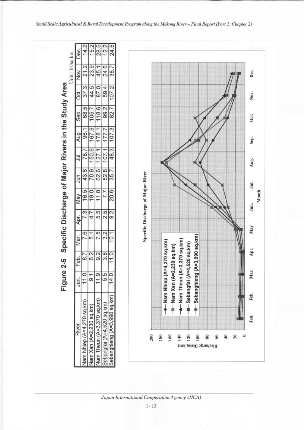
4 reliable and like most studies in the periphery, the mean values at these stations are adopted to describe the climatic conditions of the study area (Figure 2-1 and Table 2-1). Mean temperature in Vientiane is 26.5 (1997) and at Savanakhet it is slightly lower, High temperature is recorded during April June and the cool months are December and January. Mean monthly maximum temperature can be as high as 31 35, while mean minimum temperature is about (b) Rainfall Distribution in the Study Area Rainfall distribution in the study area showed great spatial variation and is a consequence of the topographic features of the region. The topographic effect of the mountains on rainfall is most pronounced in Paksan where the mountain range runs very close to Route 13 and Mekong. Mean annual rainfall of Vientiane is 1,677mm ( ), Paksan 3,270mm ( ), Thakhek 2,137mm ( ) and Savanakhet 1,454mm ( ). Figure 2-2 shows the monthly distribution of rainfall in the study area. In Paksan the monthly peak occurs in June or July while in Thakhek and Savanakhet the peak comes a month later, in August. A two-hump peak (June and August) is observed at Savanakhet. Rainfall is not always adequate for rice cultivation. The relatively high average annual rainfall conceals the years where regional rainfall may be half or less of the norm, causing significant declines in rice yields. Short intervals of drought in the rainy season also delay transplanting and/or destroy crop and harvest. (2) Hydrology Hydrological records at two stations (Thakhek and Savanakhet) along the Mekong in the study area were collected and analyzed. According to past discharge data, the average annual discharges of Mekong River at Thakhek (373,00km 2 ) and Savanakhet (391,000km 2 ) are 7,719 m 3 /s and 7,687m 3 /s, respectively. As elsewhere in the Mekong basin, seasonal runoff pattern is distinct. The peak normally occurs in August September and the lowest in March April. Seasonal variation of discharge in the mainstream - the Mekong - is large, as evidenced by the large water level fluctuation, about 10m, observed at Thakhek (Figure 2-3). All of the rivers in the study area flow into the Mekong. The major ones are Nam Mang, Nam Ngiap, Nam Xan, Nam Kading, Nam Don, Sebangfai and Sebanghiang (See Location Map). Daily water level is observed at some gauging stations of the major rivers, although some gaps exist in the data record. There had been little data on discharge observation limited only to the very few major gauging stations. I - 9
5 Table 2-1 Meteorological Conditions of the Study Area Average Temperature (Mean Max and Min) ( ) Station Jan Feb Mar Apr May Jun Jul Aug Sep Oct Nov Dec Average Vientiane Max Min Savannakhet Max Min Average Temperature (1997) Station Jan Feb Mar Apr May Jun Jul Aug Sep Oct Nov Dec Average Vientiane Savannakhet Duration of Sunshine (1997) Unit: hours Station Jan Feb Mar Apr May Jun Jul Aug Sep Oct Nov Dec Averege Vientiane Savannakhet Average Maximum and Minimum Humidity (percent) (1997) Station Jan Feb Mar Apr May Jun Jul Aug Sep Oct Nov Dec Average Vientiane Max Min Savannakhet Max Min Figure 2-1 Meteorological Conditions of the Study Area Maximum and Minimum Relative Humidity Max, Min and Average Temperature Maximum 35 Maximum Relative Humidity (%) Minimum Temperature ( ) Average Savannakhet 15 Minimum Jan Feb Mar Apr May Jun Jul Month Aug Sep Oct Nov Dec Jan Feb Mar Apr May Jun Jul Month Aug Sep Oct Nov Dec I - 10
6 Figure 2-2 Monthly Rainfall in the Study Area Rainfall (mm) Monthly Rainfall in the Study Area Paksane Thakhek Savannakhet Jan. Feb. Mar. Apr. May Jun. July Aug. Sep. Oct. Nov. Dec Month Figure 2-3 Monthly Water Level Fluctuation (Mekong River at Takhek) Monthly Water Level (Mekong at Takhek) Water Level (m) Y.1992 Y.1993 Y.1994 Y.1995 Y.1996 Jan Feb Mar Apr May Jun Jul Aug Sep Oct Nov Dec Month Figure 2-4 Monthly Water Level Fluctuation (Sebangfai River) Water Level (m) Monthly Water Level (Sebangfai, Station 53) Y.1991 Y.1992 Y.1993 Y.1994 Y.1995 Y Jan Feb Mar Apr May Jun Jul Aug Sep Oct Nov Dec Month I - 11
7 Based on the results of hydrological analysis of the major rivers, it is evident that the runoff pattern of these rivers is similar to that of the mainstream - Mekong. However, seasonal fluctuation of water levels in these rivers is great, reaching 10m. Typical runoff pattern of the major rivers is shown in Figure 2-4 (Sebangfai). Peak water level occurs in July August and lowest in April. Most of the runoff occurs frequently in the period from July October. The average annual discharge of the major rivers and the average annual runoff in m 3 /s of the major rivers in the study area are presented below: Average Runoff of the Major Rivers in the Study Area River Catchment Average annual Discharge Data Record (km 2 ) (m 3 /s) Nam Ngiap 4, Nam Xan 2, Nam Theun 3, Sebangfai 8, Sebanghiang 19, Note: Data source DOMH In terms of the monthly discharge data, specific discharge of the major rivers was calculated as shown in Figure 2-5. Specific discharge in April varies from l/s/km 2 and in August l/s/km 2. In the calculation, the stations in the upstream were the preferred data source to minimize the influence of water used/drafted for irrigation which is true for most of the stations in the downstream reaches Soils The flood plains are separated from the Mekong River and other major rivers. These floodplains are being flooded each year. In these areas, the soils consist of deep, poorly drained clay to clay loam soils with moderate soil fertility and the permeability is low. The soils are generally good for paddy production. The low terraces are located at slightly higher elevation than the flood plains; hence, they are rarely flooded from the rivers. Along some stretches of the major rivers, large riverbanks that can be cultivated during the dry season after the water level of the river have lowered sufficiently. The soils in the study area are divided based on geological origin. The soils are further subdivided into soil units depending on physical features. Hereunder are the characteristics of the major soils in the study area: Gleysols: The soils in the floodplains consist of deep, poorly drained clay to clay loam soils, which are yearly flooded for some time during the wet season. The fertility of the soils is moderate, and the permeability is low. The soils are good for paddy soils, especially in the dry season, when there is no flooding problem. I - 12
8
9 Gleric Acrislos: The soils on the low terraces consist of deep, poorly drained loam to clay loam soils, with clay loam subsoil. The fertility of the soils is generally low, and the permeability is low. The soils are good soils, both in wet and dry season, although the nutrient status is somewhat low. Ferric Acrisols: The soils at the lower part of the middle terrace are deep, imperfectly drained soils, with a sandy loam to loam topsoil, and a clay loam subsoil. The fertility of these soils is low, and the permeability is moderate. The soils are moderate paddy soils under rainfed conditions, but constitute rather good paddy soils under irrigation. Humic Lixisols/Ferric Alisols: The soils at the upper part of the middle terrace are moderately deep to deep, well-drained soils, with a thick sandy loam topsoil and a loam to clay loam subsoil. The fertility of these soils in low to moderate, and the permeability of these soils are high. Fluvisols, Luvisols: The soils of the levees consist of deep, well-drained loamy soils. The fertility of these soils is moderate, and the permeability is high. Fluvisols: The soils of the riverbanks consist of deep, well-drained sandy to loamy soils. The fertility of these soils is moderate to high, and the permeability is very high. All soils have very low to low amount of available P, and low to moderate amounts of available K. The amount of N, which depends on the organic matter content of the soils varies from moderate to very low. The ph of the soils is rather low on soils used for paddy cultivation land on the low and middle terrace (ph ), and somewhat higher on the levees (ph ). The area and distribution pattern of the soil units in the study area is presented in Table 2-2 and Figure 2-6, respectively Water Resources As elsewhere, water resource in the study area can be categorized into river and reservoir. In Bolikhamsai and Khammouane, the main water resource is the rivers, while in Savanakhet large number of farm ponds and small reservoirs are built across streams to store water for dry season use. Water is seldom a problem in the wet season. In some areas excessive runoff from the rivers overtops the banks and cause inundation which can be a problem to wet season rice cultivation. In the dry season the discharge in the major rivers and the Mekong has high potential for irrigation. This is one of the reasons that many pump irrigation projects, large and small, are constructed along the downstream reaches of the major rivers and along the Mekong to exploit whatever water is available for dry season irrigation. I - 14
10
11
12 However, since most of the projects are not predicated upon detail planning, depending on topography and accessibility to river water, some of these projects may encounter water deficiency in the dry season. Also, in some districts, the pumps are so closely spaced along the rivers that competition for water could be a problem. Erosion of the banks where some of the pumps are located is also a precursor to the imminent problem of water unstable resources. Due to the recent massive and ad hoc introduction of pump irrigation and the incipient impact of the pumps which appeal to a wide audience, it is rather difficult for the farmers to receive the new pumping plans with relative equanimity. By now the farmers are harder to be convinced to invest in other state-of-the-art or traditional ways of water resources development. In due time, the farmers will have to face and comprehend the inherent problems such as pump repairs, overhaul cost, maintenance and replacement. With the IMT and the government policy on the eventual transfer of assets to farmers, the farmers cannot sidestep a more balanced and realistic approach a combination of all feasible ways - to water resources development - a notion shared by many involved in planning and design Flood Conditions Flooding has been a part of life and the nutrient-rich silt-laden floodwater is believed to be the source of fertility in the low-lying areas of the study area. Most of the riparian inhabitants consider flood to be helpful as long as it is not too deep and/or does not stay too long. It is difficult to subdue and contain the dynamic flow of the Mekong since it swells to over times in the rainy season. Flooding indeed limits land availability for agriculture and postpones cropping when water supply is excessive. It is clear that the three major low-lying plains - Bolikhamsai, Sebangfai and Sebanghiang - are inundated by a complex flood mechanism, both by the backwater of in-basin runoff and intrusion of the rising water in the Mekong. According to DOMH, the main cause of flooding is the backwater of runoff from heavy rainfall in the basin resulting from plugging at the river mouths. Unfortunately, no data on flood condition such as flood stage, discharge, inundation depth and duration, are available, except for the flood in 1995/96. It is therefore difficult to assess the conditions of frequent flood. However, the flooding condition in 1995 and 1996 can shed some light on what can be expected in the rainy season. According to the information collected, the causal factor of flood in 1995 was different from that in Based on rough analysis, the 1995 flooding was caused by the intrusion of flood discharge in the Mekong. In 1996, the large runoff in the Sebanghiang has caused the flooding since the runoff was considerably larger than that of the previous year. However, the 1995 flood was much more severe than in Analysis of maximum water level at Vientiane, Thakhek and Savanakhet stations has shown that in 1995 the maximum flood I - 17
13 stage of the Mekong was more than 1/10 return period. The amount of rainfall in the basins was also much more than the average. Damage on agriculture was reported as follows: In Bolikhamsai basin, about 48,000ha was flooded to a depth of 2 8m over 2 8 weeks. Of the 11,164ha of agricultural land, about 9,097ha was flooded and harvest of 8,088ha was damaged. In Sebangfai basin, about 41,500ha, including 9,800ha in Xaibouri district, was flooded to a depth of 1 6m over 1 8 weeks. About 13,000ha of rice field was affected and about 11,000ha was damaged. In 1996 about 40,000ha in Sebanghiang basin was flooded to a depth of 1.5 8m over 2 6 weeks. About 10,000ha of rice field was damaged. 2.2 Socio-Economy General The study area consists of 4 districts in Bolikhamsai province (Thaphabath, Bolikhan, Paksan, and Pakkading), 4 districts in Khammouane province (Hinboun, Thakhek, Nongbok, and Sebangfai), and 4 districts in Savanakhet province (Xaibouly, Khanthabouly, Xayphouthong, and Songkhon). The total study area is approximately 15,265 ha and extends along the Mekong River, with 6,079 ha in Bolikhamsai province, 5,216 ha in Khammouane province, and 3,970 ha in Savanakhet province. The economy of the study area is dominated by rice with some other crops such as tobacco, maize, and vegetable along the Mekong River and its tributaries, and some upland crops (pineapple, sugar cane, and tapioca) in areas with low water resource potential. There are also upland rice productions using the traditional slash and burn cultivation in the latter area. The major roads in the study area are the National roads No. 13, No. 4, No. 8. The road No. 13 that is along the Mekong River from up-stream Bolikhamsai to down stream Savanakhet is considered as the main road. The National Road No.4 joins Bolikhamsai province and Xieng Khouang province is not passable during the wet season. The National Road No.8 joins Bolikhamsai province to the Vietnam border at Laksao is in good condition all year round. Secondary access roads joining district to district in the study area are of poor quality and are flooded or cut during the wet season. The water resources of the area consist of the Mekong River and its main tributaries. The main tributaries that are providing water and water resource to the rural community in the area are; Nam Mang, Nam Leuk, Nam Giap, Nam San, Nam Sa, Nam Kading, and Nam I - 18