Asia-RiCE 2017/Phase 2 Implementation Report
|
|
|
- Brianne McDaniel
- 5 years ago
- Views:
Transcription
1 Asia-RiCE 2017/Phase 2 Implementation Report
 initiative.")

 outputs that have been enabled by the initiative.")

2 Asia-RiCE has been organised to develop the rice crop estimation and monitoring component for the GEO Global Agricultural Monitoring (GEOGLAM) initiative. GEOGLAM aims to enhance agricultural production estimates through the use of Earth observations, and Asia-RiCE seeks to ensure that the observational requirements for Asian rice crop monitoring are reflected in the GEOGLAM priorities. This report summarises the activities and achievements of Asia-RiCE in 2017/Phase 2 by providing examples of Technical Demonstration Site (TDS) outputs that have been enabled by the initiative. This document also aims to acknowledge and highlight the impact of contributions from data providers, and the role of the Asia-RiCE initiative in facilitating these inputs. Compiled by: Edited by: Matthew Steventon (Symbios Communications) Matthew Steventon, Stephen Ward, George Dyke (Symbios Communications); Shinichi Sobue, Kei Oyoshi (JAXA) Copyright 2018; JAXA, Symbios Communications
3 Table of Contents Introduction 1 Key Achievements 3 Technical Demonstration Site Achievements 5 Indonesia 5 Vietnam 7 Cambodia 9 Myanmar 11 Japan 13 India 15 Conclusion 17
4 Introduction Background and Scope The Asia-RiCE initiative has been organised to develop the Asian Rice Crop Estimation and Monitoring (Asia-RiCE) component for the GEO Global Agricultural Monitoring (GEOGLAM) initiative. GEOGLAM aims to enhance agricultural production estimates through the use of Earth observations, and Asia-RiCE seeks to ensure that the observational requirements for Asian rice crop monitoring are reflected in the GEOGLAM priorities. The goal of Asia-RiCE is to foster the widespread use of EO for wall-to-wall, whole country, timely and accurate forecasts of rice production at national, regional, and global scales, as an input to the GEOGLAM Crop Monitor and AMIS Market Monitor. Asia-RiCE is leveraging existing agricultural monitoring programs and initiatives at local levels (which serve as the Asia-RiCE Technical Demonstration Sites (TDS)) to develop, exercise and refine processes from stakeholder engagement, through resource marshalling and deployment, and on to trial implementation and product generation using SAR (i.e., radar) and other Earth observation data for rice crop monitoring. To achieve the overall goal of timely and accurate forecasts of rice production, TDS sites will need to develop and refine the generation of a number of key products, including rice crop area and yield estimations. These target crop and agricultural products are summarised in Table 1. It is expected that these products will be generated with national resources as input to crop forecasting systems. Product P1: Rice Crop Area Estimates/ Maps P2: Crop Calendars/Crop Growth Status P3: Crop Damage Assessment P4: Agro- Meteorological Information Products P5: Yield Estimation And Forecasting Table 1 Target Products for Asia-RiCE Description Cultivated area (every year). Inventory of agricultural facilities. Timing of sowing, planting, growing and harvesting/growing status. Identification of growth stages. Planted area progress (every month) per season. Crop growth anomaly. Detection of flooding and other disaster impacted area. Detection of drought or inundated area. Detection of diseased plants, pests and diseased infestation. Early warning. Anomaly detection (drought, extreme temperatures). Crop growth anomaly. Empirical-statistical model estimate. Crop-growth simulation model estimates. 01 Introduction
5 Phase 1 ( ) The activities of Asia-RiCE have been arranged into phases. Phase 1A ( ) consisted of four TDS in three countries: Indonesia, Thailand and Vietnam). Each of these was focused on the development of provincial-level rice crop area estimations. Note: Phase 1A only covered rice area statistics, maps, and yield estimates. In Phase 1B ( ), additional technical demonstration sites in Chinese Taipei, Japan, and Malaysia were added. Phase 2 ( ) Following the successful demonstration of the core functionality of Asia-RiCE, the initiative moved into Phase 2, which covered: Scaling-up rice crop monitoring using SAR (adding rice growth outlooks for Laos, Cambodia, and Myanmar). Expanding from provincial-level to country/ region-level estimates (Vietnam & Indonesia). Expanding rice growth outlooks using satellite-derived agro-meteorological data. Continuing rice growth outlooks for FAO/ AMIS and related agencies via GEOGLAM in collaboration with AFSIS (ASEAN+3 Food Security Information System). Fusion of optical and SAR data (including multi-frequency SAR) for rice monitoring. Standardization of an in situ measurement procedure. Investigation of methane emissions from paddy fields. Phase 3 (2018+) Asia-RiCE Phase 3 will be formulated in early Phase 3 will have a focus on operationalisation, methane emission evaluation at regional scales, and also research into C/L/X-band and optical integration/ comparison. Scope This report will summarise the activities and achievements of Asia-RiCE to date by providing examples of TDS outputs that have been enabled by the initiative. This document also aims to acknowledge and highlight the impact of the substantial contributions from CEOS space agencies and the role of the Asia-RiCE initiative in facilitating these inputs. 02 Introduction


6 Key Achievements Asia-RiCE works to connect in-country agricultural agencies, space agencies, and global agricultural initiatives. It s activities are therefore broad, but can be broken down into three major categories: data coordination, software/tool development, and reporting. Data Coordination The Committee on Earth Observation Satellites (CEOS) and its agencies are critical partners for Asia-RiCE. Asia-RiCE works with these space agencies to secure the data required by TDS teams for development of the target products outlined in Table 1 as well as other research activities. A key feature of the coverage being provided by CEOS agencies is the multiple band SAR (C/L/X), which facilitates important intercomparison studies. Open Data Cube & SAR ARD Open Data Cube arranges data as a multidimensional (space, time, data type) stack of spatially aligned pixels ready for analysis. The powerful time series functionality of the Data Cube platform makes it very useful for agricultural studies, including for rice. JAXA, VNSC, and members of the Open Data Cube community have been working to establish a Data Cube for Vietnam (see page 7 for details). Critical for the Data Cube is Analysis-Ready Data (ARD). CEOS, through its Land Surface Imaging Virtual Constellation (LSI-VC) has developed the concept of CEOS Analysis-Ready Data for Land (CARD4L) satellite data that have been processed to a minimum set of requirements and organized into a form that allows immediate analysis with a minimum of additional user effort and interoperability both through time and with other datasets. ALOS-2 PALSAR-2 ARD is supplied by JAXA through the JJ-FAST system to Vietnam and Indonesia for their Data Cube projects. JAXA is a co-lead of the SAR CARD4L specifications. INAHOR & JASMIN JAXA/RESTEC continued development of 03 Key Achievements
7 the INAHOR (INternational Asian Harvest monitoring system for Rice; crop planted area estimation software) and JASMIN (agro-met information provision system for outlook) tools. INAHOR estimates rice crop acreage and production using space-based Synthetic Aperture Radar (SAR) from the ALOS series, RADARSAT-2 and Sentinel-1. In 2018, JAXA/RESTEC successfully ported the INAHOR algorithm to the Open Data Cube platform. JASMIN provides satellite derived agrometeorological information including precipitation, drought index, soil moisture, solar radiation, land surface temperature, and vegetation index. The tool is able to generate two types of product for each parameter current condition, and anomaly, which is the deviation from past year s averages. JASMIN can generate either a map of the whole country or time series graphs at a number of predefined locations. The outputs assist the ASEAN Food Security Information System (AFSIS) and target country agricultural statistics experts in preparing AMIS outlooks for Asia-RiCE. Reporting Asia-RiCE continued its work with the ASEAN Food Security Information System (AFSIS) to provide crop condition overview information and outlooks to the GEOGLAM Crop Monitor for AMIS. Asia-RiCE teams also report against the five target products. A summary of the products, their status, and data use is presented below. The following sections, separated by country, highlight some of the major results achieved. Product Cambodia Indonesia Japan Myanmar Vietnam India P1: Rice Crop Area ALOS-2 ALOS-2 ALOS-2 ALOS-2 Radarsat-2 Estimates/Maps Radarsat-2 Sentinel-1 RISAT-1 Radarsat-2 Sentinel-1 P2: Crop Calendars/ Crop Growth Status P3: Crop Damage Assessment P4: Agro-Meteorological Information Products P5: Yield Estimation And Forecasting Testing ALOS-2 Scaling-up Testing & Scaling-up ALOS-2 MODIS ALOS-2, Sentinel-1 Radarsat-2 Landsat MODIS GCOM-C ALOS-2, ADB project with Philippines JASMIN On Going (GPM/DPR, GCOM-C/W, MODIS) ALOS-2 ALOS-2 Sentinel-1 Radarsat-2 ALOS-2 Sentinel-1 Radarsat-2 04 Key Achievements MODIS Resourcesat-2 AWiFS Resourcesat-2 AWiFS MODIS Resourcesat-2 AWiFS
8 Indonesia The National Institute of Aeronautics and Space of Indonesia (LAPAN) are the technical implementer and optical data provider of this TDS. LAPAN are also receiving and disseminating RADARSAT-2 data to the Indonesian teams that make up the TDS. The Indonesian Center for Agricultural Land Resources Research and Development (ICALRD), Indonesian Agency of Agricultural Research and Development (IAARD), and the Ministry of Agriculture (MoA) of the Republic of Indonesia support the production of information including paddy planted area and harvested area for the National Bureau of Statistics of Indonesia (BPS). Bogor Agricultural Institute (IPB) is acting as a technical supporter and field statistical data is provided by Badan Pusat Statistik (BPS, the National Bureau of Statistics of Indonesia, subdirectorate of food crops). In 2016, the Indonesian rice crop monitoring initiative was expanded to cover the top 10 high priority rice crop areas (in part because the East-West extent of the country means a larger number of satellite passes would be required to cover all areas). ICALRD are working with ALOS PALSAR data (provided by JAXA) for paddy growth stage analysis. Conclusions 1. ALOS-2 has the potential for paddy crop monitoring in central areas that have cloud cover problems during the wet season. 2. Valuable information available in the ALOS-2 Data Provision System can be used by decision makers to plan agricultural production facilities (fertilizer, pesticide, irrigation, etc.). 3. Results of quantitative comparisons between parameters of the INAHOR module and in-situ data show good results. However, more careful evaluation and validation of the results (after complete fine-tuning of the parameters) needs to be done. 4. Utilizing SAR data for rice monitoring in an operational and sustainable way is a future activity. ICALRD and JAXA are seeking a framework (e.g., MoU) for the continuous use of ALOS-2 data, utilizing SAFE results. Some results are presented in the following figures. 05 Indonesia

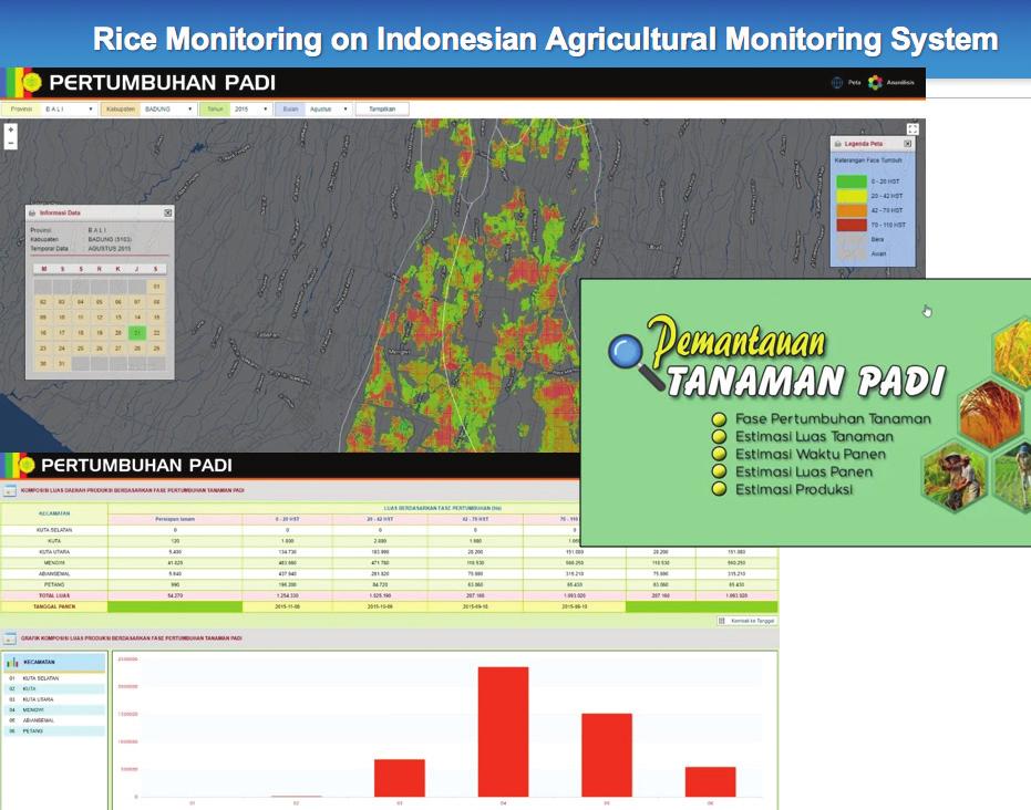
9 06 Indonesia
10 Vietnam The Vietnamese study region is located in the Mekong Delta. A selection of sampling sites are used in order to capture the diversity in rice cropping systems (two or three crops per year) and different cultural practices. For each site, measurements are performed on several fields. Ho Chi Minh City Vietnam Space Center (VNSC) / Vietnam Academy of Science and Technology (VAST) performs surveying, process and analyse data, and develop tools and models, supported by Centre d Etudes Spatiales de la BIOsphère (CESBIO), France. The team aims to evaluate the use of SAR data in rice mapping and yield estimation, towards an operational system for a rice crop inventory in Vietnam. The Vietnamese team has led the way in the application of Sentinel-1A/B data for rice monitoring. Scale-up Activities Rice crop mapping for the whole of Vietnam using Sentinel-1 has been demonstrated. Validation is planned for Asia-RiCE Phase 3. Research and Development Facilitated by the numerous SAR datasets provided by CEOS agencies over a number of years, a substantial amount of work has been done to compare results derived using various SAR bands (C/L/X). Research has recently been conducted to study methane emissions from rice fields in Vietnam, based on modeling, experimental, and EO data. Vietnam Data Cube VNSC, in collaboration with members of the Open Data Cube community, are establishing a Data Cube for Vietnam, with the initial goals of supporting forest monitoring, water quality assessment, and rice crop monitoring. JAXA ALOS-2 ScanSAR every 42 days ESA Vietnam SAR based rice crop monitoring scheme Sentinel Dual every 12 days MODIS Landsat CSIRO GA/CSIRO Data Cube Analyzed info Ground data Statistical info Met info VNSC, VAST, MARD VNSC GEORIICE MARD MONRE Asia-RiCE are playing a key role in the development. JAXA/RESTEC is porting the INAHOR algorithm and providing ALOS analysis-ready data (ARD) to support initial demonstrations. Through CNES/CESBIO, Sentinel-1 ARD have recently been ingested in the VNDC. CESBIO and VNSC have implemented a rice crop mapping algorithm and demonstrated mapping results in the VN Data Cube. 07 Vietnam

 for rice monitoring in Vietnam leveraging the VNSC Data Cube.")
11 Next Steps (Asia-RiCE Phase 3) 1. Extend the target area and increase the observation frequency; 2. Increase validation activities for rice crop estimations; 3. Capacity building activities for end users; 4. Collaboration with other SAFE Prototype activities; Stakeholder Engagement Contact has been established with the Ministry of Agriculture and Rural Development (MARD) for: 5. Continuous use of Sentinel-1 & ALOS-2 (VNSC-JAXA MOU) for rice monitoring in Vietnam leveraging the VNSC Data Cube. Data set: ALOS-2 at regional scale a) evaluation of the products with respect to the requirements; b) assessing the use of EO data for the provision of the information relevant to the GEOGLAM Crop Monitor. Related Projects For 2018, the team is conducting two projects: 1. A national project on rice crop monitoring using radar and optical EO data, led by Lam Dao Nguyen; 2. The ESA GEORICE-2 project scaling up GEORICE methods to Vietnam and other countries, led by Thuy Le Toan. Map of WS Rice 2017 (Sentinel-1 Data) 37 Map of WS Rice 2017 (ALOS-2 Data) Map of Winter-Spring 2016 rice crops in Vietnam generated from Sentinel-1 08 Vietnam
12 Cambodia One of the newest members of the Asia-RiCE team, Cambodia, through the Department of Planning and Statistics, MAFF, is working to promote rice planted area and production estimation using space-based technologies. Until now, paddy area and yield related information has been collected through typical data collection methods involving local level surveys, however, DPS/MAFF don t have any means to check the quality of statistics reported by these local offices. The aim was to develop a new information collecting method that would be cost-effective and complementary to present rice crop area and production estimations, to support statistical information generation and to verify statistics reported by local offices. Objectives 1. SAR data processing capacity building (INAHOR with ALOS-2 data). 2. Accuracy assessment of rice-planted area derived from INAHOR with field survey data and agricultural statistics. Cambodia has undertaken training with the Japanese INAHOR SAR data processing system, which estimates rice planted area and production. The software allows local officers to easily produce useful information from satellite data in just 5 steps, using a graphical user interface. Results were validated with field surveys. The error was 4.4% compared with official statistics at the provincial level. Summary DPS expects to increase the accuracy of reported values from local offices using INAHOR results. DPS confirmed the accuracy of INAHOR with ALOS-2 data. DPS will establish the validation framework using INAHOR on the actual reporting system. DPS requests JAXA provide open and free ALOS-2 ScanSAR data access and technical support to implement the new validation framework. 3. Development of a prototype validation framework for statistics reported from local offices. 09 Cambodia


13 ^ Rice planted areas from statistics were highly consistent with the INAHOR results. > Local officers used the map function on smartphones to validate reported values during field visits. 10 Cambodia
14 Myanmar is another newcomer to the Asia-RiCE team. The Ministry of Agriculture, Livestock and Irrigation Department of Agricultural Land Management and Statistics aimed to develop a system that uses innovative space based technologies for rice crop area mapping and yield monitoring. The objectives were: 1. To support the production of information on rice area, rice growth stages, and rice yield; 2. To advance the system of rice crop area mapping and yield monitoring using SAR data; 3. To substitute the existing agricultural statistical system with modern spacebased technologies. The team from Myanmar also used the Japanese INAHOR software and ALOS-2 data to estimate planted area and yield. Results were verified using 14 sample plots (200m 2 ) in the target area (Lewe township, Nay Pyi Taw). Evaluation of the resulting maps: Overall accuracy is good. Mis-classification areas were found in water body areas, dams and urban areas. There were small mis-classification areas, and more detailed validation is needed. How will the results be used in practical/ operational work? Checking the kwin-level information (planted area, etc.) collected by field survey/questionnaire. Utilizing the resulting maps for agricultural statistical data collection to conduct field surveys more efficiently and effectively. The resulting maps can be referred to for rice planted area and planning for particular purposes. Supporting the information of rice planted areas, planting times, and growth stages withimaorper2ioas. INAHOR with ALOS-2 derived statistics produced results in close agreement with official statistics. However, overestimation and underestimation of certain areas was found (overall 1.4% overestimation of planted area by INAHOR deemed to be acceptable). 11 Myanmar

15 Estimated Planting Date : 03/07/2016 : 31/07/2016 : 11/09/ Myanmar
 tools to assist the ASEAN Food Security Information System (AFSIS) and target country agricultural statistics experts in preparing AMIS outlooks for Asia- RiCE.")
16 Japan INAHOR and ALOS-2 JAXA/RESTEC provide the INAHOR (INternational Asian Harvest monitoring system for Rice, crop planted area estimation software) and JASMIN (agro-met information provision system for outlook) tools to assist the ASEAN Food Security Information System (AFSIS) and target country agricultural statistics experts in preparing AMIS outlooks for Asia- RiCE. Through an Asian Development Bank Technical Assistance project and SAFE projects under APRSAF, INAHOR (using ALOS-2) has been demonstrated to achieve mapping accuracies of 80-90% for target provinces (in Laos, Thailand, Vietnam (North), Philippines, Myanmar, Cambodia, and Indonesia). Scalingup for major rice producing areas is being demonstrated in Vietnam and Indonesia. Tsuruoka Technical Demonstration Site The Japanese TDS team (Tsuruoka City, Yamagata Prefecture) is focused on research using multiple SAR datasets. A fleet of multi-frequency SAR missions is available (RADARSAT-2, RISAT-1, ALOS-2, Sentinel-1A/1B, TerraSAR-X, etc.). Multiple-SAR data can: Enhance data acquisition reliability; Improve data acquisition interval; Identify different physical characteristics of rice crops, e.g.: C-band (VV, VH; high sensitivity in planting phase); L-band (HH; high sensitivity in vegetative/reproductive phase); Integrated use of ALOS-2 + Sentinel-1 + RADARSAT-2 can yield SAR data every 4.6 days on average. A series of online tutorials regarding the use of INAHOR with ALOS-2 data have been developed by the ADB for both participating agencies and other agencies/countries. INAHOR Outputs 13 Japan


17 Rice paddy monitoring in Tsuruoka province using multiple SAR data. Field data is collected using automated data collection stations. 14 Japan
18 India India has been performing rice area estimations using SAR data for more than 15 years. All major microwave satellite sources have been used, such as ENVISAT SAR, Radarsat 1 & 2, RISAT-1 and now Sentinel-1. Currently, rice area and production are estimated, operationally, at district, state and national levels under the national programme FASAL (Forecasting Agricultural output using Space, Agrometeorology and Land based observations). Mahalanobis National Crop Forecast Centre (MNCFC) of the Ministry of Agriculture & Farmer s Welfare (MoA&FW), Government of India, is the National Centre that provides the multiple pre-harvest rice acreage and production forecasts operationally. Rice area is estimated using multi-date SAR data, using a decision tree classifier. Ground truth data, collected using a smartphone-based Android application, is used to develop the classification logic. Up to 2012, Radarsat data was used for rice area estimation. RISAT-1 SAR data was used from 2013 to As of 2017, Sentinel-1 is used for rice area estimation. An indigenous software called FASALSoft has been developed to analyse satellite data for crop area estimation. Estimation is done for the 14 major rice growing states of the country. Rice yield is estimated using agromet models, crop simulation models and remote sensing vegetation index based models. For remote sensing based yield estimation, empirical models are developed between rice yield and vegetation indices (VIs), such as Normalized Difference Vegetation Index, Normalized Difference Wetness Index and Vegetation Condition Index. The VIs are derived from longterm MODIS 250m data. Additionally, Crop Cutting Experiments (CCE) are carried out for yield estimations at sample locations, which are determined using remote sensing based crop map and vegetation index data. The CCE yield data are used for validation of yield models and also improvement of yield estimation. Rice production estimation is carried out for both Kharif (rainy) and Rabi (winter/summer) season crops. The difference between remote sensing based rice area estimates and the government estimates are within 5-10% at state level and 2-3% at national level. 15 India

 (Right: Sentinel -1 2017")
19 Ground survey points overlaid on Sentinel-1 data for Punjab State Classified image in sample segment for Krishna district Andhra Pradesh Mean Signature Profile, Left: RISAT HH Data , Right: Sentinel 1A VV Data Year wise comparison showing the decrease in rice area in Nellore District Andhra Pradesh (Left: RISAT data) (Right: Sentinel data) 16 India
20 Conclusion A Critical and Unique Space Agency Service Asia-RiCE has demonstrated the great utility of the initiative, with substantial amounts of CEOS data flowing from space agencies to incountry agricultural agencies and researchers an achievement that would not have been possible without the collective efforts of the group and its connections to GEOGLAM and CEOS. As a result of Asia-RiCE, improved rice production estimates are being generated at national, regional, and global scales valuable inputs to the GEOGLAM Crop Monitor and AMIS Market Monitor that would not otherwise be present. Asia-RiCE thanks all CEOS agencies for their unique and critical contributions. Asia-RiCE Phase 3 will be formulated in early Phase 3 will have a focus on operationalisation, methane emission evaluation at regional scales, and also research into C/L/X-band and optical integration/ comparison. 17 Conclusion
21 18 Conclusion
22