Abhijit Nagchaudhuri, PhD, Professor, Engineering and Aviation Sciences Department Chris Hartman, MS, Program Coordinator, Aviation Science Program
|
|
|
- Maude Perry
- 5 years ago
- Views:
Transcription


1 Abhijit Nagchaudhuri, PhD, Professor, Engineering and Aviation Sciences Department Chris Hartman, MS, Program Coordinator, Aviation Science Program

2

3

4 A method of optimizing agricultural inputs to improve economics and minimize environmental impacts. Simple definition Right product Right time Right place


5 WICKED PROBLEM EASTERN SHORE PMT delays could outlast O Malley administration By BRUCE HOTCHKISS Senior Editor (July 1, 2014) Even as an intricate study continues in Maryland on the economic impact of the proposed Phosphorus Management Tool, it has become apparent that the ultimate implementation of the new nutrient management regulations could be delayed until well beyond the first of the new year. That would put it off until after Gov. Martin O Malley leaves office. The PMT s importance to the restoration of the health of the Chesapeake Bay and the priority it has received in the affairs of state is providing O Malley with political ammunition as he treads the path to a bid for national elective office. DPI lauds contributions of poultry industry By MICHEL ELBEN Staff Reporter EASTON, Md... Thanks to chickens, farmland and farm families remain on Delmarva, said Jim Smith, DPI president. Delmarva s poultry industry is responsible for nearly 10 percent of Delmarva s jobs. Smith said it takes about 73 million bushels of corn and 24 million bushels of soybeans to feed Delmarva s chickens. That acreage is larger than Rhode Island, he said.


6

7


8 UMES Combine and Yield Monitor


9 Results from the ph Field Experiment


10 Variable Rate Application of Lime

11


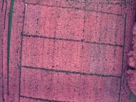
12 GRID SOIL SAMPLING SOIL TEST RESULTS ON GIS MAP ( BOZMAN FIELD)


13 Applied Research and Field Experiments utilizing Variable Rate Nitrogen Application, Remote and In Situ Sensing, and Drought Tolerant Corn Seeds


14 Why precision agriculture? The world population is growing while land useable for farming is in decline
15 The imbalance between population and farm land has been overcome by increased efficiency in farm output driven by the use of fertilizers Worldwide nitrogen-useefficiency (NUE) is said to be less than 50 %. The remainder of the N is left to enrich the atmosphere as well as ground and surface water.

16

17 The benefits of efficient N application are two-fold: minimize pollution of groundwater optimize profits for producers Proper assessment of within field crop variability is critical for improvement of NUE.


18 Applied Research and Field Experiments utilizing Variable Rate Nitrogen Application, Remote and In Situ Sensing and Drought Tolerant Corn Seeds _ _Sudduth_whitepaper.pdf


 indicative of crop biomass and nutrient stress.")
19 OPTRX SENSORS VARIABLE RATE SPRAYER Individual OptRx Active Sensor OptRx sensors are active sensors that can shine light centered on 670nm (red), 730nm (red_edge) and 780 nm (near-infrared) wavelengths and record reflectance from the crop canopy to determine VIs (vegetation indices) such as NDVI ( NIR RED ) and NDRE NIR+RED ) indicative of crop biomass and nutrient stress. ( NIR RED_EDGE NIR+RED_EDGE
 and applied N maps (right) using Ag Leader SMS")
20 VARIABLE RATE NITROGEN APPLICATION FIELD TRIAL ( 2013) Sensed NDRE (left) and applied N maps (right) using Ag Leader SMS software


21 Aerial Image and Yield Map Bozman Ent Farm Bozman -Corn

22 Principles of Aerial Imagery Fly aircraft over areas of interest with a nadir view camera Bodies in flight are not always level Induced error from motion in: Pitch Roll Yaw Relevance of Aerial Imaging in Precision Agriculture Aerial Imagery provides users with insight into crop health studies, yield estimates, land use patterns studies. 22
23

24

25
, while areas that show up in magenta were brighter in 2005 than")
26 Areas that show up green were brighter in 1975 (meaning more vigorous vegetation), while areas that show up in magenta were brighter in 2005 than 1975.


27 Undergraduate Multidisciplinary Earth Science Airborne Instrumentation Research UMES-AIR Collaboration with the University of Maryland Eastern Shore


28 Student UAVS Introductory Trainer Primary Trainer Remote Sensing (Visible-Video) UAV Remote Sensing (Vis/NIR) and Atmospheric Profiling (T/RH/P) UAV Intermediate Trainer Advanced Trainer


29 Aerial Imaging Platforms Rotomotion Robotic Helicopter ImageAire Lite II RC Light Trainer TerraHawk Equipped Cessna 172F TwinCam 29


 With UMES")

30 Low-Cost Video Cameras: Color and Near-Infrared for Normalized Difference Vegetative Index (NDVI) With UMES Natural Sciences & Engineering and Aviation Sciences Departments


31 AEROKATS Advancing Earth Research Observation Kites And Tethered Systems With AIRSPACES MD Space Grant, USDA project: Dr. Nagchaudhuri, et al


32


33 The New TwinCam

34 Visible 34

35 Thermal


")


36 Remotely Operated Vehicle for Environmental Research ROVER (Bland, Miles/610.W) Multidisciplinary Project with the University of Maryland Eastern Shore (UMES) Engineering & Aviation Sciences, Biology, Computer Science Students and Faculty Fabrication and Instrumentation Classroom Activities Deployments to Chincoteague and Chesapeake Bays
 Geospatial Data Management,")
 Constellation of 24 Satellites that transmits")
 Gabriel B.")
37 GIS, GPS, Precision Ag & Remote Sensing Geographic Information System (GIS) Geospatial Data Management, Display and Analysis Software Global Positing System (GPS) Constellation of 24 Satellites that transmits signal to ground based receivers GPS Receiver GPS Satellite (Courtesy of NASA) Gabriel B. Ladd GIS Map of GPS points


/ +")

38 AERIAL IMAGING USING TERRAHAWK CIR CAMERA SYSTEM NDVI = (NIR RED)/(NIR + RED) 38

39 Manned Aircraft Cessna 172 modified for carrying the TerraHawk Aerial Imaging system

40

41

42


43 ,

44


45 Georeferenced Mosaicked Color balanced Dec 12 th 2007 MEES Masters Thesis Defense


46 RECTIFICATION AND GEOREFERENCING Software tools : ARCGIS and MATLAB


47 FAA COA approved July 1, DRobotics X8 with Tetracam ADC Lite Series of test flights with first data acquisition on July 10

48
 sensor (")


49 The ADC Lite contains a single 3.2 megapixel Complementary Metal Oxide Semiconductor (CMOS) sensor ( single array with Bayer pattern filters)optimized for capture of visible light wavelengths longer than 520 nm and near-infrared wavelengths up to 920 nm. Bayer interpolation. A mosaic of tiny filters is placed over the array of detectors. Each pixel receives NIR, RED or Green ( shown for RGB) light in the pattern shown.
50 A Color Infrared (CIR)

51 A NDVI
52 B Color Infrared (CIR)

53 B NDVI

54


55

56

57
58 Safe and efficient data collection Aviation Program Procedures, mission planning, resource management Agriculture and Environmental Sciences Data processing to create meaningful and actionable products to end users at a marketable price Increase productivity Drive down the cost of utilization Compliance with FAA requirements
59 1972 Commercial Pilots 196K Private Pilots 320K 2011 Commercial Pilots 123K Private Pilots 195K Source : AOPA


60 USDA Capacity Building Grant MDSGC Geoff Bland and Ted Miles of NASA Dr. Craig Daughtry of USDA
61 Contacts: