Urban and Peri-Urban Food System Mapping
|
|
|
- Alison McKenzie
- 5 years ago
- Views:
Transcription
1 Urban and Peri-Urban Food System Mapping Michael Conard Houman Saberi Amanda (Behrens) Buczynski

2 Primary Research Objective To quantify the contribution of urban food production in the six focus cities. Baltimore New York City Philadelphia Pittsburg Syracuse Charleston, WV Replicate the UDL s NYC Methodology
3 Secondary Research Objective To look beyond the urban footprint to surrounding peri-urban areas To define and quantify the peri-urban contribution in a consistent manner across all six EFSNE cities
4 Peri-Urban Literature Review The term peri-urban area, cannot be easily defined or delimited through unambiguous criteria. It is a name given to the grey area which is neither entirely urban nor purely rural in the traditional sense. Important to locate the peri-urban on a continuum from urban-peri-urban-rural (U/PU/R). Linked system, constituting an uneven multidimensional continuum. Many researchers note that peri-urban is a combination of static and dynamic forces (Iaquinta and Drescher, 2000; OECD, 1979; Allen, 2003; Mattingly, 1999; Adell, 1999)
5 Peri-Urban Methodology Defined our study area Identified datasets with static or dynamic characteristics Mapped datasets over study area to create peri-urban zones Developed machine-learning algorithm to create new datasets Used zones to analyze food systems and land use within 6 EFSNE cities

6

7 Outlining the Peri-Urban
8

9
10
11 Peri-Urban/Rural Interface Peri-Urban/Rural Interface Zone 1 (Urban) Zone 2 (Peri-Urban) Zone 3 (Peri-Urban) Zone 4 (Peri-Urban) Zone 5 (Rural/Agricultural) Miles Peri-Urban/Rural Interface
12 MACHINE-LEARNING ALGORITHM

13
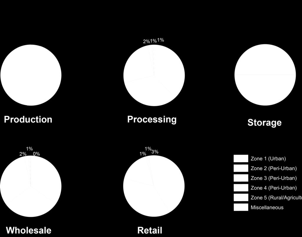
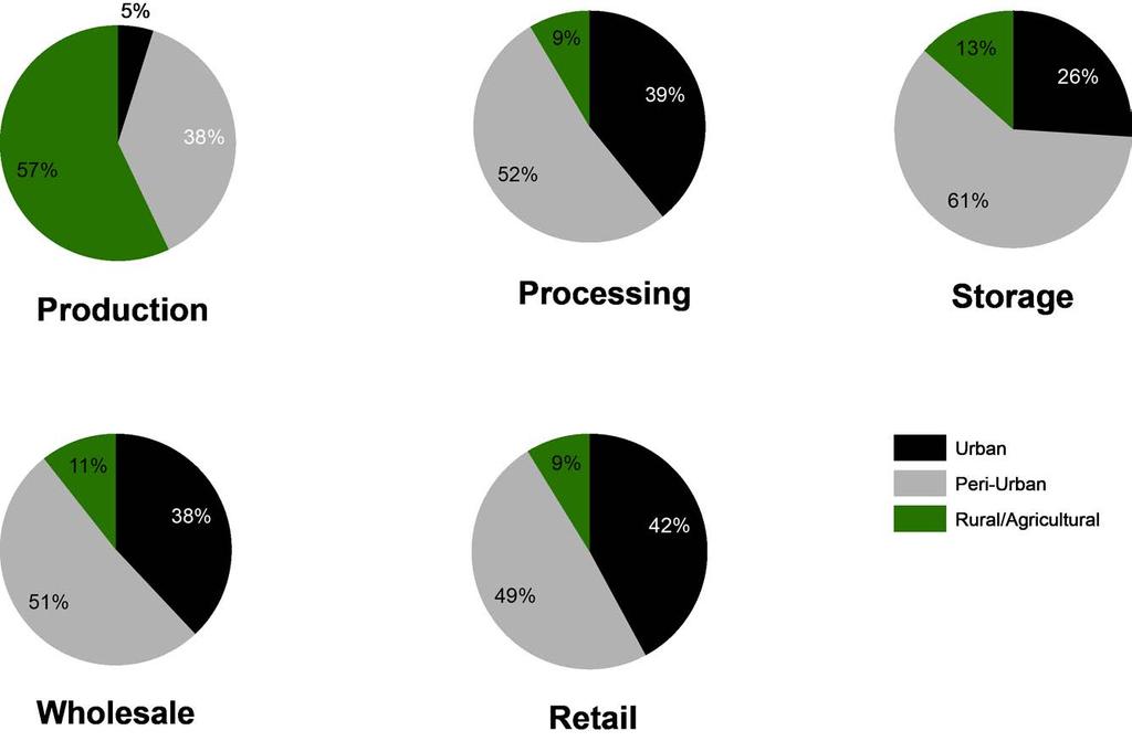
14
15
16

17
18 FOOD SYSTEMS RESULTS

19 Baltimore Food Systems
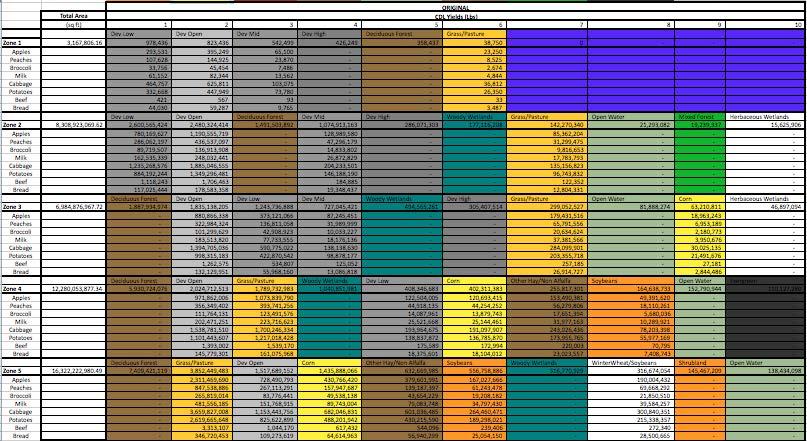
20

21 Production

22 Processing
23 Storage

24 12 State NE Region
25
26 LAND USE AND YIELDS RESULTS
 Apples Peaches")

27 Calculating Yield Placeholder Crop Yields (lbs/sq ft) Apples Peaches Broccoli Milk Beef Bread Cabbage Potatoes
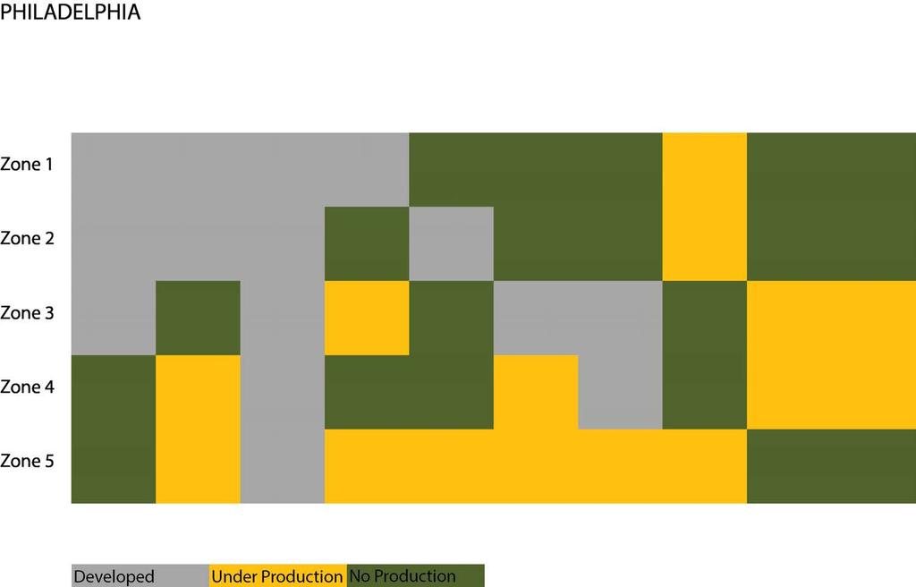
28

29

30

31

32
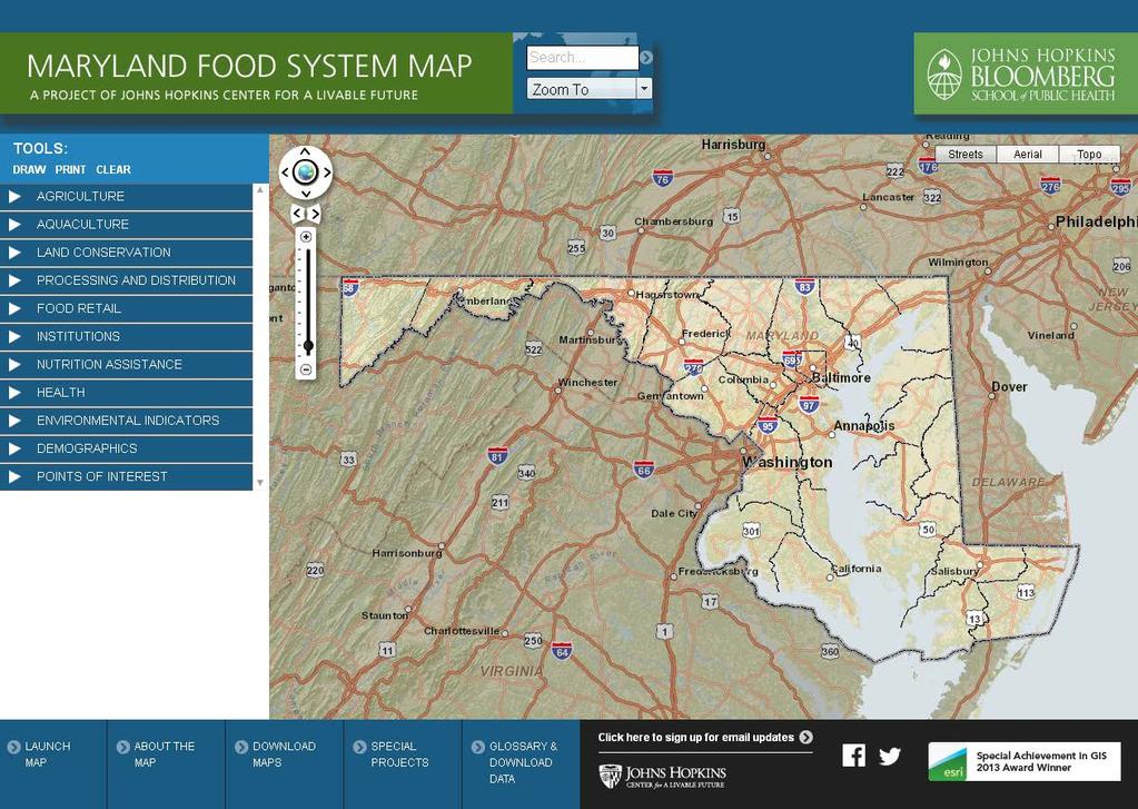
33

34


35


36 Baltimore Land Use

37

")
38 Acreage by Zone (1,000 acres)

39 Potential Market Basket Crop Yields (1,000 tons)
40 Observations and Opportunities Potential Magnitude of Contribution Quantity of Food Systems Located in the Zone This unrecognized system generates limited Management and/or Coordinated Efforts Others? Challenges Land Use Consistency across Municipalities Private Sector Food Flow Data Others? Interim Questions about the Project Methodology? How do we better understand, inform and manage this system and capability? Case Study Center for a Livable Future s Maryland Food System Mapping Project.
41 CLF s Maryland Food System Map Project Amanda (Behrens) Buczynski l


42 Center for a Livable Future Programs Food Produc7on and Public Health Industrial Food Animal Produc7on Project Teaching the Food System Curriculum Aquaponics Project Food System Sustainability and Public Health Food Waste Research Food System Policy Program Engage Public Health in the Farm Bill Food Communi7es and Public Health Bal7more Food & Faith Project Meatless Mondays Food Policy Networks Community Food Assessments Maryland Food System Map Project
43 Goals: Data/Map Repository: To develop and collect food systems data in Maryland Network Facilitator: To connect audiences to data, and to each other Capacity Building: To increase capacity within partner organiza7ons to conduct food systems work by providing tools and informa7on Data layers span many topics across the food system, and allow users to look interact with data across categories and berer understand the context of their work
44 Data Categories: «Agriculture, Land Conserva7on, Environmental Indicators «Processing and Distribu7on «Food Retail food stores, restaurants, farmers markets «Nutri7on Assistance SNAP and WIC usage We have a par7cular focus on Access to Healthy Food «Farm-to-Ins7tu7on K-12, Universi7es, Hospitals «Demographics, Health

45
46
47 Data Sourcing Majority from public sources, work with state departments and county/city departments as partners, to acquire and maintain data Some from na7onal databases, such as the Census of Agriculture and American Community Survey About 1/3 collected in-house, where public sources do not exist or are inadequate Examples: farms "that sell locally" list, processing and distribu7on, ins7tu7onal food purchasing, community kitchens, etc.

48 Census of Ag (number of orchards) & Farms Selling Locally

49 Census of Agriculture: Economics - Sales by Product


50 Processing & Distribu7on: Local Food Distribu7on Facili7es

51 Food Retail, Food Access: Food Deserts, Two Methods of Analysis
.")
52 Demographics: Self Sufficiency Standard The amount of income necessary to meet basic needs (including taxes) without public subsidies (e.g., public housing, food stamps, Medicaid or child care) and without private/informal assistance (e.g., free babysiang by a rela7ve or friend, food provided by churches or local food banks, or shared housing). $38,363 $41,380 $47,884 $62,100 $65,932 $57,906 $68,435 $67,237 $51,466 $54,017 $78,943 $73,451 $71,138 $72,150 $63,574 $51,591 $51,828 $71,042 $67,848 $50,377 $52,442 $57,642 $49,720 $51,459

53 Ins7tu7ons: % Eligible for Free and Reduced Price Meals

54 Special Projects & Map Gallery


55 PDF Maps


56 Story Map: B more Farm and Food Map

57 County Profiles: Sta7s7cs at your finger7ps

58 County Profiles example example

59 County Profiles Prince George s cont.
60 Bal7more City: Special Focus on Food Access Data Food stores supermarkets, corner stores, convenience stores In Bal7more City, all stores have been verified and surveyed (HFAI) Farmers markets Urban farms and community gardens SNAP or food stamp usage All can be overlaid with other data, for example: Demographics income, vehicles, popula7on density

61 First ever report to explain food desert methodology in detail, and discuss City programs to address the issue In-depth review of food retail environment Also new council district maps

62 2015 Bal7more Food Environment Map Food Desert De*inition: > ¼ mile from supermarket or supermarket alternative At or below 185% federal poverty level Low vehicle availability, > 30% do not have access Low Healthy Food Availability Score (average scores of surveyed stores)
 1")
 www.jhsph.")
63 Demographics of Bal7more s Food Deserts Popula7ons living in food deserts: 1 in 4 city residents (25%) 1 in 3 school aged children (30%) 1 in 4 seniors (25%) More than 1 in 3 of African Americans (35%)
 Rate of Premature Death due to Cardiovascular Disease Lowest = 50 per 100,000 Highest = 296 per 100,000 www.")
64 Health Outcomes and Food Deserts Life Expectancy Lowest = 66 years old Highest = 85 years old (20 year gap!) Rate of Premature Death due to Cardiovascular Disease Lowest = 50 per 100,000 Highest = 296 per 100,000
65 Bal7more City s Food Desert Retail Strategy 1. Financial incen7ves for supermarkets 2. Support non-tradi7onal grocery retail 3. Improve public markets 4. Homegrown Bal7more & farmers markets 5. A transporta7on strategy
66 Famers Markets (showing where SNAP is accepted) Community Gardens Note: Difficult data to collect! Urban Farms

67 Bal7more City USDA Food Deserts & Emergency Food Sites


68 Bal7more City CLF Food Deserts & Emergency Food Sites Our detailed analysis is a more accurate picture of food access
69 Who we ve worked with, Our Partners: Food Policy Councils our #1 audience Montgomery County Food Council (MCFC) Prince George s Food Equity Council Bal7more Food Policy Ini7a7ve Southern Maryland Food Council Harford County Food Policy Task Force Results of our collabora7on: USDA changed grant applica7on parameters due to our Bal7more Food Desert Map MCFC conducted community food assessments & HFAI survey Southern MD created own maps for on the ground use Bal7more City enacted new legisla7on around SNAP Benefits Conducted food swamp analysis for Howard County
70 Partner Organiza7ons, cont. Advocacy Groups Maryland Hunger Solu7ons Maryland Food Bank and partners Educa7onal Ins7tu7ons Johns Hopkins School of Public Health access to students! University of Maryland Extension/ Land Grant Local Colleges students can help with data collec7on State Departments Agriculture, Environment, Natural Resources, Health, etc.


71 Thank you! Please feel free to keep in touch: Follow us! MDfoodmap on:
72 THANK YOU! Michael Conard, RA NCARB Houman Saberi