JECAM SAR cross sites experiments
|
|
|
- Douglas Parrish
- 5 years ago
- Views:
Transcription
1 JECAM SAR cross sites experiments H. McNairn, I. Jarvis, A.Davidson, P. Defourny, G. Chomé, F. Waldner Agriculture and Agri-food Canada UCLouvain-Geomatics, Belgium and the JECAM SAR researchers and/or site managers
2 Preliminary roadmap (1st JECAM Meeting) SAR cross sites experiments on JECAM sites: Multi-user license created! Common acquisition plan and preprocessing level AAFCanada to share his expertise in SAR ag. Application A. Crop type identification (incl. multi-frequency) B. LAI monitoring at parcel level Future SAR experiment plans ( )

3 2015 RADARSAT time series over 7 sites thanks to CSA through CEOS based on 2014 JECAM meeting decision Multi-user license submitted to site managers Dataset made recently available to JECAM sites
 over")

4 Sentinel-1 acquisition plan : IW (VV-VH) over several sites
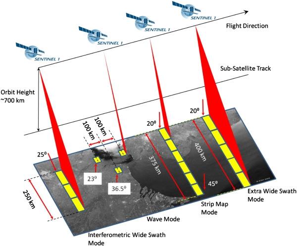
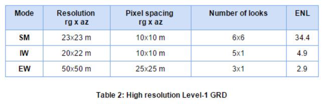
5 Sentinel-1 resolutionfor IW (VV-VH) in many sites
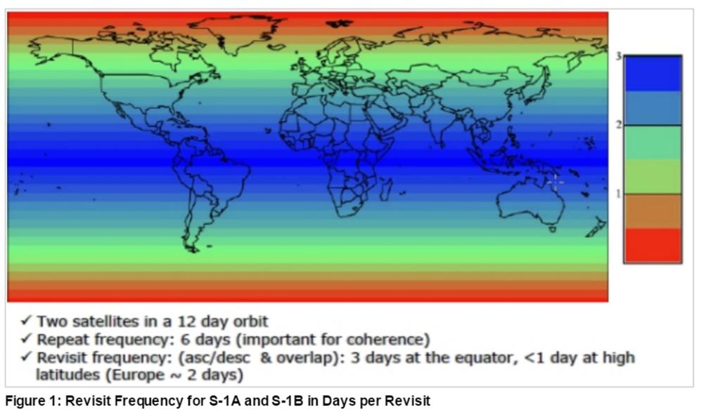
6 SAR C-band availability for 2015 growing season Opportunity for 2016 and later Satellites with SAR C-band JECAM Sites RADARSAT-2 Sentinel-1A Total Argentina Belgium Burkina-Faso China-Taishan China-Yangzhou China-Yucheng United States Total ALOS-2 PALSAR acquisition (L-band) and S1 time series : Taiwan site possibly Argentina site + Vietnam AsiaRice sites Sentinel-1 A plan could maybe be expanded on ad hoc requests Sentinel-1 B to be launched in late 2016 (tbc)

7 2015 dense SAR time series for 7 sites
8 JECAM SAR roadmap (2015 sets) SAR cross sites experiments on JECAM sites: Multi-user license created! Common acquisition plan and preprocessing level AAFCanada to share his expertise in SAR ag. applications A. Croptype identification (incl. multi-frequency): definitionof a experimentalprotocol(methods, training set for 2015 validation set for 2015 Ancillary : meteo, DEM, parcel delineation layer - Whatisthe currentstatus of 2015 in situ and anc.? - Whoare the partners interestedby a SAR collaborative researchon croptype mappingover the 7 JECAM sites?
 : JECAM South Nation site (2013) : 8 TerraSAR-X dual-polarization strip mode and 15 RapidEye frames obtained through JECAM-CEOS agreement End of season TerraSAR-X crop classification:")
9 AAFCanada JECAM SAR research results (McNairn et al., 2009, 2014) : JECAM South Nation site (2013) : 8 TerraSAR-X dual-polarization strip mode and 15 RapidEye frames obtained through JECAM-CEOS agreement End of season TerraSAR-X crop classification: Ottawa 2012 Overall accuracy: 97.2% Early season: Corn can be identified at V6 or 6 th leaf collar stage (about 6 weeks after planting) McNairn, H., Kross, A., Lapen, D., Caves, R., and Shang J Early season monitoring of corn and soybeans with TerraSAR-X and RADARSAT-2, International Journal of AppliedEarth Observation and Geoinformation 28 (2014) McNairn et al. 2014
 : 3 SAR obs. to optical obs.")
10 AAFC research and operations results (McNairn et al., 2009, Fisette et al., 2013) : 3 SAR obs. to optical obs. increase crop type accuracies (up to 16%)
11 JECAM SAR experiment fo crop type identification : initial proposition of 2 to 4 classification strategies to be discussed STRATEGY 1 STRATEGY 2 SAR time-series SAR time-series Segmentation Random forest classification Random forest classification Cropland map Cropland map Validation Validation
12 Initial proposition of 2 to 4 classification strategies to be discussed STRATEGY 1 STRATEGY 2 STRATEGY 3 STRATEGY 4 SAR time-series SAR time-series SAR time-series SAR time-series Field boundaries Selection of SAR images (SM, rain, etc) Selection of SAR images (SM, rain, etc) Segmentation Field boundaries Segmentation Random forest classification Random forest classification Random forest classification Random forest classification Crop type map Crop type map Crop type map Crop type map Validation Validation Validation Validation
13 JECAM SAR roadmap (2015 sets) SAR cross sites experiments on JECAM sites: Multi-user license created! Common acquisition plan and preprocessing level AAFCanada to share his expertise in SAR ag. applications A. Croptype identification (incl. multi-frequency): B. LAI monitoring at parcellevel(lead : H. McNairn): definition of experimental protocols(what crops? What stages?) similar in situ LAI definition and measurements appropriate sampling over space and time - Whatisthe currentstatus of 2015 in situ and anc.? - Whoare the partners interestedby a SAR collaborative research on LAI retrieval over different JECAM sites?
14 Leaf Area Index Monitoring with SAR LAI is an important indicator of crop productivity and is directly linked with yield modeling Retrievals using optical have been successful, but cloud cover is an impediment especially given the importance of temporally dense observations for crop production monitoring SAR scattering is intrinsically related to the structure of the target, and thus SAR responses (backscatter and polarimetric responses) are quite sensitive to both crop LAI and biomass JECAM SAR LAI experiment proposition : Evaluate 2-3 methods for LAI retrieval over JECAM sites, incl. these options Methods using parameterization of the Water Cloud Model under development at AAFC and UCLouvain Empirical modeling Other modeling approaches proposed by collaborators Consider adaptation of methods to biomass retrieval McNairn et al. AAFC
15 Leaf Area Index from RADARSAT-2 SAR modelling with Water Cloud Model 0 E 0 σ = AL cosθ (1 exp( 2BL / cosθ )) + σ soi exp( 2BL / cosθ ) Total backscattered by the whole canopy (σ o ) at incidence angle (θ) σ 0 veg = AL 2 cosθ (1 τ ) Vegetation component E 2 τ = exp( 2BL / cosθ) σ = C + 0 soil DM s Soil component τ 2 is the two-way attenuation through the canopy layer L is the LAI, expressed in (m2m-2) A,B,C,D and E are model coefficients defined by experimental (A,B, E depend on canopy type) Approach by AAFC uses two or three SAR polarizations to simultaneously retrieve LAI and soil moisture (no ancillary needed) but soil moisture errors still high. LAI retrieval for corn and soybeans has been successful (both L- and C-band) Approach by UCL combining SAR polarizations to estimate LAI and SWAP model for soil moisture

 than accuracies using")


16 LAI from RSAT-2 June 16, 2012 July 10, 2012 Manitoba, 2012 LAI estimates for corn and soybeans using WCM August 6, 2012 August 30, 2012 Accuracies with C-and L-band similar (or better than) than accuracies using optical Corn HH-HV Corn VV-HV Soybeans HH-HV SoybeansVV-HV R Hosseini, M., McNairn, H., Merzouki, A., and Pacheco, A., Estimation of Leaf Area Index (LAI) in corn and soybeans using multi-polarization C-and L-band radar, Remote Sensing of Environment, vo. 170, pp , 1 December 2015.
17 SAR LAI Monitoring Next Steps - Whatisthe currentstatus of 2015 in situ and anc.? - Whoare the partners interestedby a SAR collaborative researchon croptype mappingover the 7 JECAM sites? => series of conference calls to develop a short work plan, and a plan of action Initiative could be led by AAFC; AAFC could host visiting scientist/postdoc/graduate students funded by JECAM participants, to work on analysis at their Ottawa lab Interest from AAFC Integrate additional to create a more robust model Extend corn/soybean model to other crops, in particular wheat Adapt current model to estimate above ground biomass Improve simultaneous retrieval of soil moisture under crop canopy
18 Future JECAM SAR experiment plans SAR obs. requirements for (RST-2, S1a&b, PALSAR, TerraSarX)? - Is there other SAR research objectives to be investigated? - Whoisinterestedby a SAR collaborative researchas participant / as leader? - Whoisinterestedby a SAR-opticalcollaborative researchas participant / as leader?! In 2016, Canada will again play host to a SMAPVEX cal/valcampaign; excellent opportunity for international participation. SMAPVEX12 was highly successful involving 75 scientists from U.S. and Canada, and has been supporting many graduate theses. SMAPVEX12 included extensive collection of LAI, biomass and soil moisture ; collection of airborne and satellite SAR
19 Some JECAM partners references JECAM/GEOGLAM Science Meeting Hosseini, M., McNairn, H., Merzouki, A., and Pacheco, A. (2015). Estimation of Leaf Area Index (LAI) in corn and soybeans using multi-polarization C-and L-band radar, Remote Sensing of Environment, 170, pp Wiseman, G., McNairn, H., Homayouni, S., and Shang, J. (2014). "RADARSAT-2 PolarimetricSAR response to crop biomass for agricultural production monitoring", IEEE Journal of Selected Topics in Applied Earth Observations and Remote Sensing, 7(11), pp Bériaux, Emilie ; Lucau-Danila, Cozmin; Auquiere, Eric; Defourny, Pierre. Multiyear independent validation of the water cloud model for retrieving maize leaf area index from SAR time series. In: International Journal of Remote Sensing, Vol. 34, no. 12, p (2013). Bériaux, Emilie ; Lambot, Sébastien; Defourny, Pierre,2011. Estimating surface-soil moisture for retrieving maize leaf-area index from SAR. In: Canadian Journal of Remote Sensing, Vol. 37, no. 1, p (February 2011). doi: /m Jiao, X., McNairn, H., Shang, J., Pattey, E., Liu, J., and Champagne, C. (2011). The sensitivity of RADARSAT- 2 polarimetricsar to corn and soybean Leaf Area Index, Canadian Journal of Remote Sensing, 37(1), pp BlaesX., VanhalleL., Defourny P., Efficiencyof cropidentification basedon opticaland SAR time series, Remote Sensing of Environment, 96,

 Development")


20 Every year once : Crop type Row orientation Plant density 4 to 7 times over a season: Leaf Area Index (LAI) Development stage On ad hoc basis: Yield Fresh and dry biomass Soil moisture incl. GPR JECAM/GEOGLAM Science Meeting Regular in situ collection
:")
")


21 Synchroneous field campaign: LAI measurements Leaf Area Index (LAI): the one-sidedgreen leaf area per unit of ground surface area (m²/m²) estimate from hemispherical photo using CAN-EYE 15 winter wheat fields visited in dates of hemispherical photographs/ field Fish-Eye lens Spatial sampling example


22 LAI measurementsalong2013 intensive EO acquisition campaign SPOT4 (take 5) RapidEye (ESA) Landsat 8 February March April May June July August RADARSAT-2