FY24 28 JAXA. Big BCG
|
|
|
- Colleen Norman
- 5 years ago
- Views:
Transcription


1 RESTEC


2 FY24 28 JAXA 37 3 Big BCG 4


3 ( + + ) National Spatial Data Infrastructure Theme Maps (1/5,000, 1/10,000,1/25,000, 1/50,000) ( ) GIS ADB GSMaP Input Rain gage Improved Flood prediction model Precipitation Existing system Output GSMaP I/F(1) Estimated Precipitation Calibration & Validation I/F(2) Model I/F(4) Web GIS I/F(5) ALOS DSM I/F(3) Terrain model (SMS) 6


4 GSMaP 1 Inundated area detection Status of inundation on industrial estates have been derived from Airborne SAR as well ALOS-2/PALSAR-2 have same capability If observed by ScanSAR mode wide areas are covered almost everyday
5 JAXA GSMaP GSMaP 9 COSMO-SkyMed


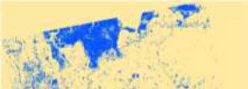
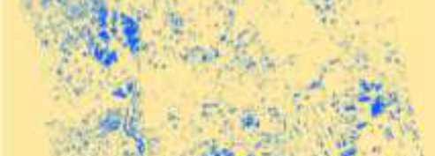

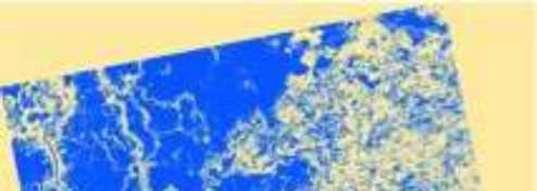

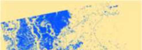


6 CSK 30min. 5min. 30min. 25min. 8 Lee Low KML/KMZ HIMAGE 2011/08/ /09/ /10/ /10/ /01/ /12/ /11/ /11/ /08/ /11/ /11/ /01/01
 Core Satellite Global Precipitation Measurement (GPM) Launch in early 2014 GMI")
 Constellatio n Satellites Core Satellite (JAXA, NASA) Dual-frequency Precipitation")

7 KaPR: 35.5GHz radar (phased array) Core Satellite Global Precipitation Measurement (GPM) Launch in early 2014 GMI (Microwave Imager) KuPR: 13.6GHz radar (phased array) Constellatio n Satellites Core Satellite (JAXA, NASA) Dual-frequency Precipitation Radar (DPR) GPM Improve Microwave the accuracy Imager of (GMI) weather forecasts Improve water resource management Item Abbreviatio n Swath Width Horizontal Resolution Observatio n Range Minimum Detect Ze (Rainfall Rate) GPM Dual-frequency Precipitation (DPR) TRMM Precipitation Radar KuPR KaPR PR 245 km 120 km 245 km < 18 dbz (< 0.5 mm/hr) 5 km 5 km Upto 19km < 12 dbz (< 0.2 mm/hr) Upto 15km < 23 dbz (< 0.7 mm/hr) 14
8 15 11 G20 / / / / / ASEAN+3 /G20/ASEAN/APEC/FAO/ AFSIS APEC / / (JAXA/JICA/


 Optical")
 Products from satellite data")


9 Developing the Observation Requirements of GLAM Only one sensor / satellite can not solve application requirements - Multi-satellite observation including international constellation is definitely needed. Satellites/Sensors SAR Microwave Radiometer Data Integration RADAR Optical Sensor (Global Imager) Optical Sensor (High Res.) Products from satellite data addy Field Mapping Flood Monitoring Crop Growth Agro-meteorological Monitoring Topography Agricultural Applications Agricultural Stat Early Warning Damage Assessment 18 Land Resource Management


10 GCOM-W,TRMM ASEAN+3 AFSIS) FAO AMIS 10 GEOGLAM JASMIN - Data-Provision Each data will be updated every 15 day (twice a month: 15th, 31th). Users can access and get latest data any time. 20

 Solar Radiation 15-day Average 5 km 2007- (2007-2012) MODIS Land Surface Temperature 15-day Average 5 km 2002- (2002-2012) MODIS Soil")
![Moisture 15-day Average 50 km 2009- (2002-2012) AMSR-E, WINDSAT Drought Index 15th /31[30]th day of month 10 km 2003- (2003-2012) GSMaP,](/docs-images/89/98676171/images/11-4.jpg "MTSAT Vegetation Index 15th /31[30]th day of month 5 km 2002- (2009-2012) MODIS 21 precipitation.")
11 Assessment Source for Rice Growth Outlook Satellite observation provides and information and they are updated every 15 days (twice a month). Parameters Interval Spatial Resolution Data Period (anomaly calc.) Satellite Data Source Precipitation Cumulative (15-day) 10 km ( ) GSMaP (GCOM-W1, TRMM, MTSAT etc.) Solar Radiation 15-day Average 5 km ( ) MODIS Land Surface Temperature 15-day Average 5 km ( ) MODIS Soil Moisture 15-day Average 50 km ( ) AMSR-E, WINDSAT Drought Index 15th /31[30]th day of month 10 km ( ) GSMaP, MTSAT Vegetation Index 15th /31[30]th day of month 5 km ( ) MODIS 21 precipitation. Precipitation -day Few precipitation can causes drought and too much precipitation can causes flooding. Current Condition Anomaly Much Much Less Less 22
12 JAXA INAHOR International Asian Harvest monitoring system for Rice SAR ALOS PALSAR RADARSAT-2 Geotiff 23 Framework for Rice Crop Monitoring System 4. Dissemination System NDVI, NDWI etc. 1. Paddy Field Mapping SAR (backscatter) Crop Damage Assessment Crop Calendar Timing of the observations Crop Intensity Paddy Field Map Productivity (Yield per Unit) Production 3. Procuctivity Estimate Agricultural Stats Crop Model in-situ / stats Agro-meteorology Crop Condition 2. Agro-met and Crop Condition Monitoring System Precipitation, Soil Moisture, Drought Index, PAR, LST NDVI, LAI, WSI


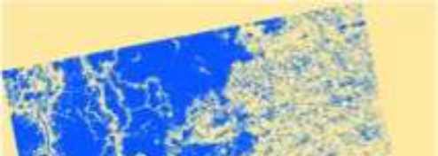
13 Basic Concept of crop area detection Planting Season Growing Season 17 th Jul. 1 st Sep. 17 th Oct. Khonkean [p482, f310] Field 1 Field 2 0 Field 3 Field 4-5 Field 5 Growing -10 Flooding or Planting Jun Jul Aug Aug Sep Oct Oct ALOS, Radarsat Paddy Rice Area 164, , % % ALOS 26


 TDS -")


 Phase 1A: 2013-2014")


14 Multi-season crops Variable crop calendars within a season Diverse growing practices Special Characteristics of Asian Rice Crop Growing Regions Water resource dependency (Water stress irrigated, rain-fed) Rainy season growth (cloud) TDS - Technical Demonstrator Sites Data processing / analysis plan with ground validation 100km x 100km sample sites (provisional level) Phase 1A: Indonesia, Thailand, Vietnam Early results available in December 2013 and discuss at APRSAF, Vietnam Phase 1B: mid Additional countries: Chinese Taipei, China, India, Japan, LaoPDR, Malaysia, Philippine, Wall-to-wall in Thailand 28

15 29 ALOS-2 30
 UAV")


16 SMS, SNS ( ) UAV 32