FIGHT IT TODAY! Innovative Approaches to Tackle and Mitigate Disaster
|
|
|
- Gilbert Jefferson
- 5 years ago
- Views:
Transcription
1 FIGHT IT TODAY! Innovative Approaches to Tackle and Mitigate Disaster Educating a new breed of Professionals in Dr. Indrajit Pal, Assistant Professor, Disaster Preparedness, Mitigation and Management, Asian Institute of Technology, THAILAND indrajit-pal@ait.asia


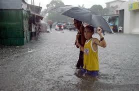

2 NATURAL DISASTERS Disasters strike with little or no warning, affecting both developed and developing countries

3

4 The extent of damage from a disaster depends on: The impact, intensity and characteristics of the phenomenon, and How people, environment and infrastructure are affected by that phenomenon
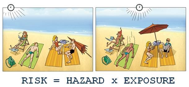
5 The level of risk depends upon: Nature of the hazard Vulnerability of elements which are affected Economic value of those elements
6

, Kobe Earthquake (Japan),")
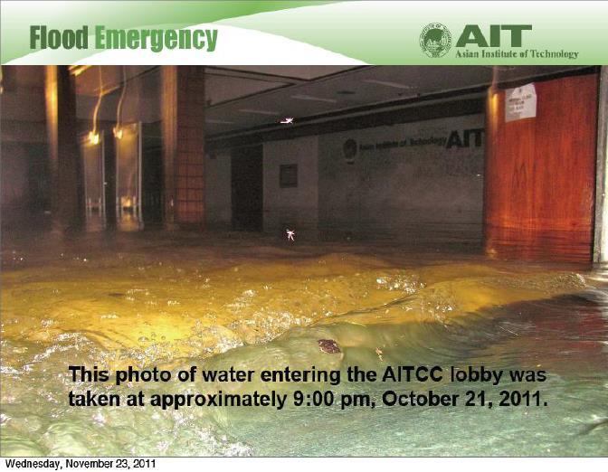
7 2011 Thailand Flood Thailand Flooding 2011 Historical flooding after 1995 Flooding in 2011 began in July until December World Bank estimate this as fourth costliest disaster after Tsunami (Japan), Kobe Earthquake (Japan), Hurricane Katrina (USA)
8

9 Disaster Management Continuum


10 A Paradigm Shift from Crisis Management to Risk Management

11 Regional Disaster Trends The Asia-Pacific region is the world s most disaster prone, and accounts for the largest cumulative increase in disaster occurrences. Over the last decade, 43 per cent of global natural disasters occurred in the Asia-Pacific, representing 83 per cent of the global total population affected and 50 per cent of total economic costs associated with them. Distribution of Hazards in South Asia Furthermore, a person living in Asia-Pacific is twice as likely to be affected by a natural disaster than a person living in Africa, six times more than in Latin America and the Caribbean, and 30 times more likely than someone living in North America or Europe. Source: ESCAP 2015

12
13 Asia-Pacific Disaster Profile The world reported over $2.8 trillion in economic losses from natural disasters between 1970 and 2013, while over the same period Asia-Pacific alone reported $1.15 trillion accounting for over 40 per cent of the global total. Between 2004 and 2013, 43 percent of total recorded global disasters occurred in the region at a total cost of $73.8 billion, up from $1.8 billion in the 1970s. On average, economic losses resulting from disasters impacting Asia-Pacific countries as a percentage of GDP is nearly 52 per cent higher than the rest of the world. Source: ESCAP
14 Total Recorded Diaster Occurences Toatal Recorded Economic Costs (USD billions) Asia-Pacific Recorded Disaster Occurrences and Economic Costs ( ) Source: EM-DAT database (2016) Years Occurrence Economic Loss Linear (Occurrence) Linear (Economic Loss) 0 14
15 What Science and Technology can do? Science can play a prominent role in the future by helping to improve monitoring and detection technologies, and by devising better ways to integrate scientific observations and data to allow us to create better models for forecasting the impacts of the natural disasters that will inevitably take place."
16 Tsunami Warning and Mitigation for the Indian Ocean Region 26th December 2004, massive earthquake (M 9.1) - Indian Ocean Tsunami - killed 230,000 people and caused widespread destruction. Although we cannot prevent tsunamis, early warning of their approach combined with physical defences and well-practiced evacuation procedures can save many lives. Prior to 2004, tsunami were not considered as a high-risk hazard. Tsunami science was a niche scientific field, with little translation of knowledge into practice, even though scientists published work on a possible ocean-wide tsunami in the Indian Ocean just months before the 2004 event.

17 The Science and Technology development The early 1960s - The development and acceptance of plate tectonic theory. The first global seismographic network was established in 1961, allowing earthquakes to be monitored worldwide. By the 2000s, great advances had been made in earth observations, computer modelling of hazards and telecommunications. Electronic sensors were developed that could rapidly detect earthquake shaking on land and tsunami waves at sea. Computer models were developed that simulate tsunami impacts on communities; and satellites could now transmit signals to high-speed computers, empowering humans to issue local and pan-oceanic tsunami warnings in minutes.
 - 24/7 network of very active TWFPS (Tsunami Warning Focal")
18 Indian Ocean Tsunami Warning Center - 28 member states bordering Indian Ocean including India, Sri Lanka Bangladesh, Pakistan and Maldives - Regional tsunami service providers are India, Australia and Indonesia - Consists of 25 seismographic stations and 6 DART buoys (Deep-ocean Assessment and Reporting of Tsunami buoys) - 24/7 network of very active TWFPS (Tsunami Warning Focal Points)
19 Early Warning Systems: A Tool for Mitigation and Coordination Conceptual framework concerning Early Warning. Monitoring of precursors to natural events. Early Warning Systems (EWS) operate on a very simple operational framework. Precursors to events are monitored on a continuous basis. Data is analyzed to generate a forecast. If there is a forecast of a large event, a warning is issued. In the modern framework of EW the emergency committees will begin actions as proposed in the emergency plans. NO Forecasting: Will there be an event? Initiate actions according to emergency plans YES Issue a Warning or an Alert.


20 Geoinformatics in Disaster Management Remote Sensing GIS / GPS Communication W W W / Internet
21 Remote Sensing and GIS: Role in Disaster Management Disaster prevention Disaster preparedness Disaster relief Disaster recovery Catalogues with spatial component Hazard assessment Elements Disaster plans at risk mapping Vulnerability Anomalies Mapping Organise the extend damage in a assessment time of disaster series Risk Damage information assessment mapping Spatial Forecasting Co-ordinating post-disaster Decision census relief Support Systems Prediction Evacuation information& Early Warning Monitoring sites for reconstruction Update hazard, vulnerability and risk data bases


22 Disaster Management : What Space Contributes? PRE-DISASTER POST-DISASTER VULNERABILITY ANALYSIS DISASTER MONITORING IMMEDIATE RESPONSE PREPAREDNESS RELIEF WARNING RECOVERY FORECAST MODELS VIGILANCE SYSTEM REHABILITATION IMPACT STUDY


23 Tsunami: Inputs for Relief/ Rehabilitation Cadastral Overlay for Inundated Area


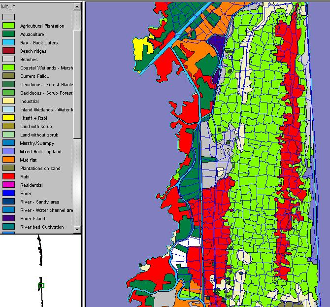
24 Disaster Mapping - Flood Damage Assessment Post Flood Land-Use Villages Roads Database layers Flood Layer Flood Layer Village Layer Integrating in GIS Marooned Villages Kimjhara Pathar Marooned Villages 27 No. Block Khalarbari Mikirgaon Gagalmari Gagalmari N Belar Bari Gagalmari No-1Boal Guri Garubandha Damage Assessment Gandhibori Kachamari Pathar Kahibari Niz Dandua Babdhali Source: NRSA, India.
25 mkisan Mobile Solution for Climate Resilience Country : India Impact of climate change o Unpredictable of weather patterns o More frequent extreme weather conditions
26 mkisan Problem ofarmers rely on national met agencies with low capacity and obsolete technologies onon-localized weather forecast information Solution ointegrated Mobile Network Operators (MNOs) using Location-Based Service (LBS) to provide weather forecasts, warnings and agronomic advices for individual smallholders.
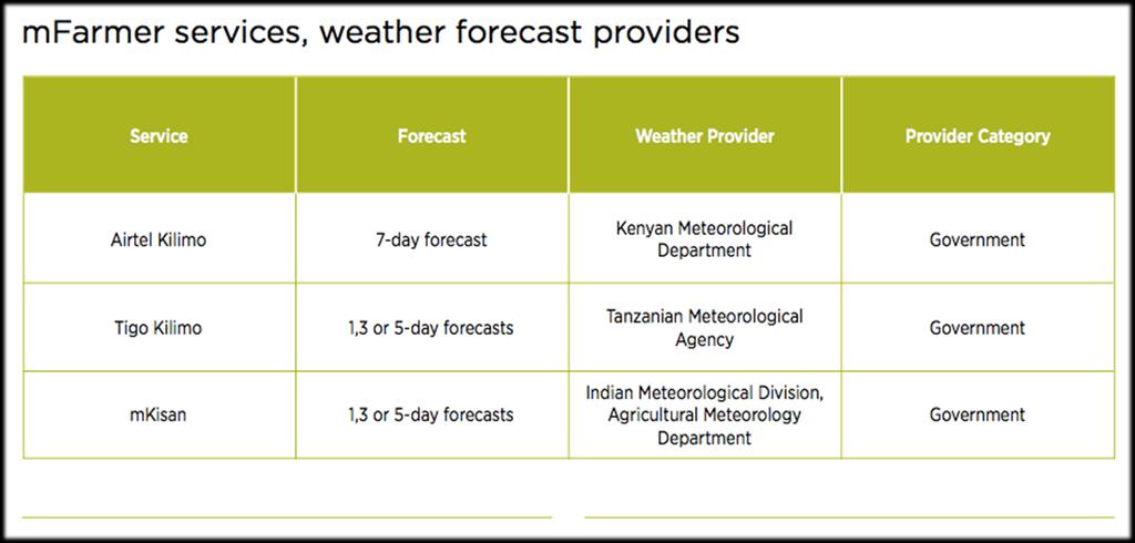
27 mkisan


28

29 Alert and Warning!! Cyclone NILOFAR Heavy to very heavy rainfall is expected from 30th Oct. morning over Gujarat due to NILOFAR cyclone. Harvest matured rice and picking cotton immediately, keep harvested produces in safer place. Postpone sowing of chickpea, sweet corn and planting of sugarcane. Arrange for extensive drainage facilities to remove excess water from standing crop fields. Undertake propping in sugarcane and provide mechanical support to young fruit plants to prevent lodging due to high wind. Keep animal indoor during the period.
30 Adoption of new technologies on disaster management (selected countries) Improved seismic surveillance networks Improved tsunami early warning and monitoring Improved telephone-based information and warning capabilities Countries currently members of the international charter on Space and Major Disasters for sharing data from their satellites in case of disasters Australia, Canada, Colombia, France, India, Indonesia, Italy, Japan, Mexico, Turkey, United States Australia, Colombia, India, Indonesia, Italy, Japan Australia, Austria, Estonia, France, Italy, Japan, Luxembourg, Netherlands, Slovak Republic Algeria, Argentina, Brazil, Canada, China, France, Germany, India, Japan, Nigeria, Korea, Turkey, United Kingdom, United States and European Space Agency
31 Existing Gaps TECHNO- LOGICAL INADEQUACY OBSOLETE INCOMPATIBLE INAPPROPRIATE INFO SUPPORT - TIME -COVERAGE -PRECISION GAPS OPERATIONAL COMMUNICATION GAPS POOR DATABASE LACK OF MEN & MACHINES INEFFECTIVE PLANNING IMPLEMENTATION MONITORING Information Gathering and Dissemination POLICIES REGULATION RESTRICTION ACCOUNTABILITY CONSTRAINTS DATABASE CREATION/ INFO GENERATION


32 Risk Assessment Considerations Hazard Exposure Vulnerability Risk monetary loss and casualties Event Generation Exposure Information Damage Estimation Social and economic losses Intensity Calculation Loss Calculation
33 Major Issues and Challenges 1. Difficulties in Data sharing among different countries/economies. 2. More research required on causes and consequences of disasters in South Asian countries. This is a multifaceted problem with research needs in the physical sciences, social and economic sciences, and technology. 3. Lack of higher education specialized in disaster management and DRR. 4. Linkages and platforms are missing between academia, practitioners, governments, and policy-makers to encourage an ongoing dialogue that crosses all borders. 5. Disaster awareness and knowledge at community level is insufficient.

34 FIGHT IT TODAY! Thanks... Educating a new breed of Professionals