Clay Distribution Patterns and Alteration in the Athabasca Basin Northern Saskatchewan. Ken Wasyliuk Chief Geochemist
|
|
|
- Bernard McDonald
- 5 years ago
- Views:
Transcription

1 Clay Distribution Patterns and Alteration in the Athabasca Basin Northern Saskatchewan Ken Wasyliuk Chief Geochemist
2 Outline Introduction Clay Mineralogy Analytical Techniques Common Sampling Techniques Other Important Information Review Historical Information Clay Distributions Regional Scale District Scale Deposit Scale Drill Hole/Hand Sample Current Sandstone Clay Alteration Model Clay Distribution in Basement Rocks Exploration Highlights / Implications Kaolin Group Minerals in the Athabasca Basin
3 Clay Mineralogy Small hydrous layer silicates, generally of low temperature origin, that are part of the phyllosilicate family (Weaver, 1989) without the size (<2 µm or <4 µm) connotation (dickite booklets seen in thin section >50 µm in size) Common in Athabasca Group: Illite (potassium aluminum silicate) (K,H3O)(Al,Mg,Fe) 2 (Si,Al) 4 O 10 [(OH) 2 Kaolin Group (Dickite, Kaolinite, S-Kaolinite) aluminum silicates Al 4 Si 4 O 10 (OH) 8 Chlorite (Sudoite, Mg and Fe chlorites) (Al 6 Mg 4 )(Si 6 Al 2 ))O 20 (OH) 16 Dravite (Magnesiofoitite, Zhang, 2000) [](Mg 2 Al)Al 6 (BO 3 ) 3 (Si 6 O 18 )(OH) 4
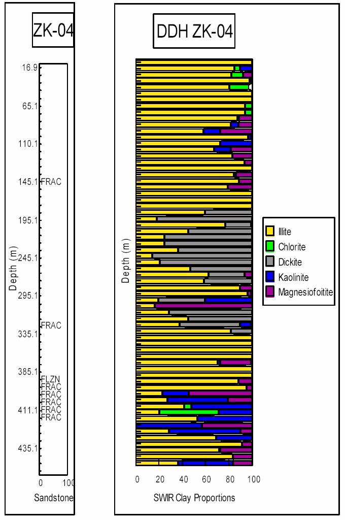
4 Analytical Techniques Normative calculated illite, chlorite, kaolinite ± dravite proportions based on the assumption that all the Al 2 O 3, MgO, K 2 O and B contents are associated with the clay minerals X-ray Diffraction either whole rock or clay separates Shortwave Infrared Reflectance Spectroscopy PIMA or ASD


5 Short-wave Infrared Reflectance Spectroscopy first introduced to Athabasca Basin in 1994 by Steve Earle of Grasswood Geoscience portable, rapid and relatively inexpensive utilizes nm wavelength region of electromagnetic spectrum capable of providing structural and chemical information capable of distinguishing the common clay minerals in the Athabasca Basin most importantly distinguishes kaolin polytypes dickite and kaolinite limited by the quality of the available spectral library and is not able to provide a total clay content
6 Common Sampling Techniques Composite Samples boulder or drill core regular intervals primarily sandstone Systematic Samples regular intervals sandstone or basement lithologies Selective Samples sandstone or basement lithologies

7 Comparison Systematic Sampling Intervals best compromise between sample representivity and efficiency was found to a standard five meter sample interval
8 Other Important Information Mapping / Drill Logging Petrography Isotopes (stable and radiogenic) Geochemistry (multi element with majors and pathfinders) All of which will assist in placing any observed distribution patterns into the proper geological context
9 Ore Formation Models (Hoeve and Quirt, 1984; Fayek, 1996) W faults Oxidized Basinal Fluids -U, HREEs, Cu unconformity SIMPLE TYPE -lower total REE contents -HREE/LREE>1 COMPLEX TYPE -high total REE contents -HREE/LREE 1 -Ni, Co, Cu, As Reduced Basement Fluids -REEs, Ni, Co, As E silicified zone massive quartz graphitic paragneiss MIS96039
10
11 Historical Information
12 Clay Alteration Models (Earle and Sopuck, 1989)
13 Regional Illite Distributions (from Earle & Sopuck, 1989) KEY % of samples with >60% I/I+K from 10m above unconformity to to top of sandstone. >25 >50 CIGAR MIDWEST DAWN RABBIT McCLEAN McARTHUR RIVER KEY LAKE MC97008
14 KEY LAKE Regional Clay Distributions (from Earle & Sopuck, 1989) MCARTHUR RIVER
15
16
17
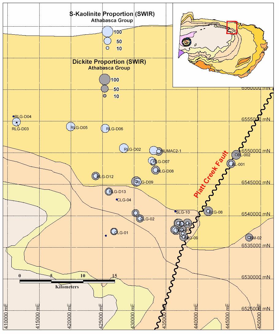
18 Regional Clay Distribution Patterns
19
20
21
22 MFd Larocque Lake MFc Midwest Lake Natona Bay Q11A Cigar Lake MFb Rabbit Lake McClean Lake Sue Dawn Lake Northeastern Athabasca Basin Dominant Clay Mineralogy Dickite >80% Dickite >60,<80% Mixture Illite & Dickite Illite >60%,<80% Illite >80% Mixture Illite & Kaolinite Kaolinite >60% Mixture Kaolinite & Dickite Chlorite >40% Dravite >40% Mixture all Clay Species (Dickite) Mixture all Clay Species (Kaolinite) Thorburn Lake Kilometres
23 McArthur River Southeastern Athabasca Basin Dominant Clay Mineralogy MFd Zone K Zone M MFc MFb Dickite >80% Dickite >60,<80% Mixture Illite & Dickite Illite >60%,<80% Illite >80% Mixture Illite & Kaolinite Kaolinite >60% Mixture Kaolinite & Dickite Chlorite >40% Dravite >40% Mixture all Clay Species (Dickite) Mixture all Clay Species (Kaolinite) Key Lake Kilometres

24 Southeastern Athabasca Basin Kaolinite and Dickite Distributions
25 Northern Athabasca Basin
26 Deposit Scale Clay Distribution Patterns

27 Maverick

28
29

30

31

32 Maverick Deposit Section ML-61 Looking West
33
34 McArthur River Project Clay Estimates in Boulders Percent clay Proportion 1.45 km E 0.00 (DEPOSIT) 2.00 km W % Illite % Kaolinite % Dickite % Chlorite % Dravite MC97006
35
36
37
38
39
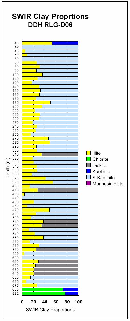
40 Drill Hole and Hand Sample Clay Distribution Patterns
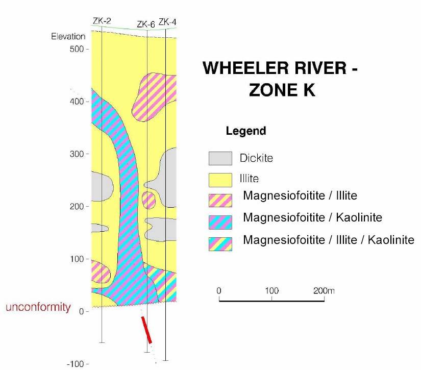
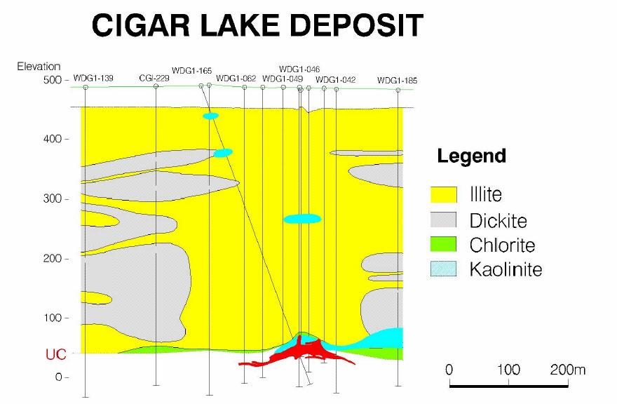
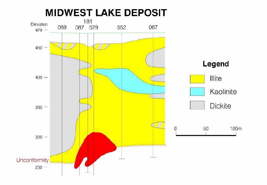
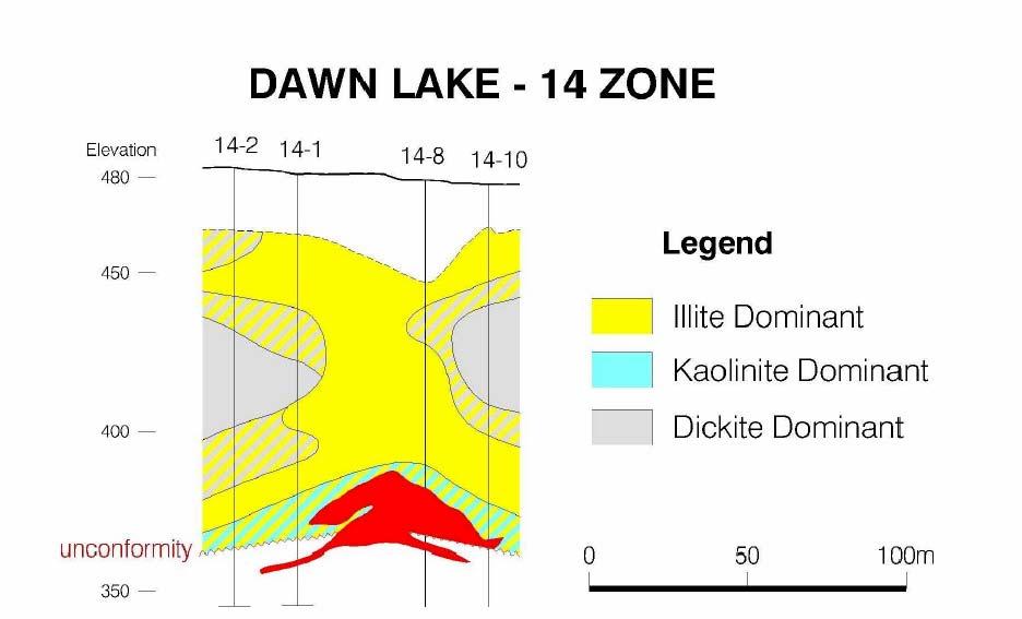
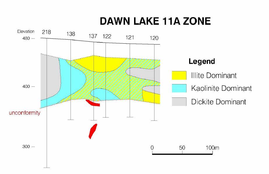
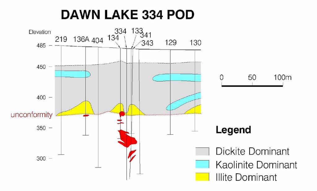
41
42
43 SANDSTONE ALTERATION MODELS (1999) Illite & Dravite Chlorite Variable Silicification Dravite Chlorite Kaolinite Illite & Dickite Illite Minor Kaolinite Dickite Dickite Kaolinite UC Variable Silicification Illite Clay Bound Illite, Chlorite Hematite
44 Clay Distributions in Basement Rocks
45 O SM PEG SM B PL M ARKS SM PELT SM ARKS PEG SM PEG SM PEG SM PL PL PL M PL M PL M ARKS G PEG PEG PEG G PL F P L M M M R A N Hole Name :ES-214 EPT_Study.dhx Segment Start Depth :0.00 Segment End Depth : Alteration Rabbit_Rocks Gamma Syst em at ic_ausspec em at ic_m iner Syst em at ic_ausspec em at ic_m iner a Syst em at ic_ausspec Syst em at ic_m I NSPEC Syst em at ic_ausspec s tematic _M ineralo GeochemDepths Depth At Index ock_type_co U3O8 Illite_comp lite_sym Illite_xtal o x ox Smectite_sym Chl_Cb_prop ILL_C1 CHL_C2 DICK_C3 Chl_comp Chlor it e_sym iotite_symfe2o3t tri-acid MgO tri-acid wt MnO tri-acid wt wt % % % o K2O tri-acid wt % Na2O tri-acid wt % B Na2O2 fusion ppm Ba tri-acid ppm Zn Partial ppm As Partial ppm Mo P artial ppm U Fluorimetry P artial ppm 50 +#x#o #o#o+# o 100 o o xoxoxo*oxo xo +oxo o o o +x*+*xo#+ +# # #+ #x # x # * *x*# o o 350 o xo* x o x o #*#*#ox +o+ x Scale 1: /20/03 21:14:13
46 Exploration Highlights (Basement) illite/chlorite proportional increases with alteration intensity (somewhat controlled by lithology and not manifested in chemistry) biotite and Fe chlorites preserved in fresh pelitic gneisses Fe depletion (bleaching) manifested in higher Mg chlorites Na-Ba-Zn is depleted from all lithologies and intensifies with alteration U-B plus typical pathfinders (Ni,Pb,As,Mo etc.) enriched in all lithologies
47 O B ARKS SM ARKS SM SM SM ARKS SM PEG SM PEG SM PEG G PEG SM PEG PL PL PL PL PL M PL M PL M F P L M PL M CAL C PEG SM PEG SM PEG G PEG G PEG G PEG G PEG PEG PEG G M PL M PL M F P L M F P L M F P L M F P L M M M R A N Hole Name :ES-296 EPT_Study.dhx Segment Start Depth :0.00 Segment End Depth : Alteration Rabbit_Rocks Gamma Syst em at ic_ausspec em at ic_m iner Syst em at ic_ausspec em at ic_m iner a Syst em at ic_ausspec Syst em at ic_m I NSPEC Syst em at ic_ausspec s tematic _M ineralo GeochemDepths Depth At Index ock_type_co U3O8 Illite_comp lite_sym Illite_xtal Smectite_sym Chl_Cb_prop ILL_C1 CHL_C2 DICK_C3 Chl_comp Chlor it e_sym iotite_symfe2o3t tri-acid MgO tri-acid wt MnO tri-acid wt wt % % % K2O tri-acid wt % Na2O tri-acid wt % B Na2O2 fusion ppm Ba tri-acid ppm Zn Partial ppm As Partial ppm Mo P artial ppm U Fluorimetry P artial ppm o x o x o x oxo oxo x o o#o+o#ox*+#+#+ o o o xoxoxoxoxox*oxoxoxoxoxo+oxo+o+o+o*oxoxo oxo o o +x+o#o+o+o#+#+#+x+#+#+#+x+o+x#x#+x #x*#x*#x o x x+#x*x#x#xo+ o # #o Scale 1: /20/03 21:15:41
48 Exploration Highlights (Sandstone) dickite is commonly developed in regional holes away from mineralization illite, kaolinite, dravite and chlorite are commonly developed near mineralization similar clay distributions occur around mineralization in both north and in south (ie. Dawn Lake) dickite--->illite--->kaolinite+-dravite/chlorite these clay distributions can occur on all scales (from individual faults within drill holes, to deposit, district and regional) regional clay alteration patterns are reflected in both the drill core and boulder geochemistry alteration crosscuts stratigraphy in the Manitou Falls Formation variations of clay patterns at all scales indicates that the clay minerals are sensitive indicators of hydrothermal and diagenetic events however the variations at the regional, local and deposit scale also show the need for consistent sampling and the establishment of background clay patterns use clay distributions as a vector towards hydrothermal centres and mineralization
49 Kaolinite Group Minerals in the Athabasca Basin
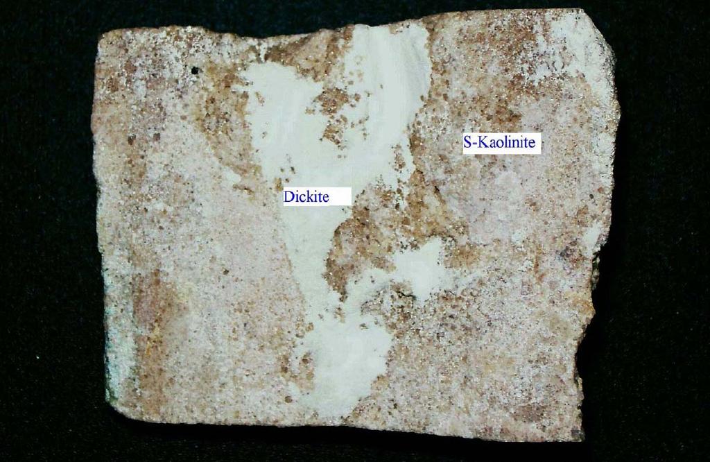
50 Dickite (standards) Kaolinite (standards) S-Kaolinite (Mixed Layered) Athabasca Basin 1400 nm
51 Athabasca Samples with Unique SWIR Characteristics 100% Kaolinite Experimental Samples Mechanical Mixtures 90% Kaolinite/10% Dickite 50% Kaolinite/50% Dickite 10% Kaolinite/90% Dickite 100% Dickite
52
53
54
55 KAOLINITE MINERAL SETTINGS IN ATHABASCA BASIN Fault zone BARREN MINERALIZED Alteration halos REGIONAL d - k - d - Late Fractures Alteration haloes d - k - 2 k - Mineralization Sandstone k - d - Regional 2 k - Athabasca Group All Members Manitou Falls Formation k - k - Paleoregolith k - U/C Late Fractures d - k - Ore Mineralization Basement k - Wollaston Group L e g e n d 2 k = kaolinite d = dickite k = S-kaolinite (mixed layer)
56 Fault zone BARREN SETTING OF KAOLINITE GROUP MINERALS WITH LOW D VALUES < -90 MINERALIZED Alteration halos REGIONAL d - D = RL8D LMS k - D = RD8C-9009 k - D = - 86 ML m Late Fractures k - D = M204/547 Alteration haloes d - D = - 90 A7O-024 k - D = M121/BL10 2 k - D = - 94 A7O-020 Mineralization Sandstone k - D = MAC Athabasca Group All Members Manitou Falls Formation U/C Ore Mineralization Basement k - D = M132/BK2 Wollaston Group k = kaolinite L e g e n d d = dickite 2 k = S-kaolinite (mixed layer)
57 Fault zone BARREN SETTING OF KAOLINITE GROUP MINERALS WITH HIGH D VALUES ~ -40 to -60 MINERALIZED Alteration halos REGIONAL d - D = - 58 SP k - D = - 58 ML m d - D = Late Fractures Alteration haloes d - D = - 56 MAC121-BL-7 k - D = - 52 DDHBF Mineralization Sandstone Regional d - D = - 58 HAM k - D = Athabasca Group All Members Manitou Falls Formation k - D = - 45 CQ m Paleoregolith k - D = - 42 EP033/180.5 U/C Paleoregolith k - D = - 59 PK7D-PK31-10 Late Fractures d - D = -53 DA9D Q m Mineralization Basement Wollaston Group k = kaolinite L e g e n d Ore d = dickite 2 k = S-kaolinite (mixed layer)
58 Polytype (# of samples) δd ( ) (mean) δ 18 O ( ) (mean) Undifferentiated (13) -35 to 167 (-90) 8.8 to 12.7 (12.5) Dickite (19) -49 to 116 (-72) 9.2 to 14.1 (11.8) S-Kaolinite (3) -52 to 94 (-67) 9.8 to 12.7 (11.4) Kaolinite (44) -45 to 176 (-121) 6.3 to 17.1 (11.7)
59 Fault zone BARREN KAOLINITE MINERAL SETTINGS IN ATHABASCA BASIN ISOTOPIC COMPOSITION RANGES OF KAOLINITE GROUP MINERALS MINERALIZED Alteration halos REGIONAL d - D = - 59 to = 10.2 to 12.6 k - D = - 52 to = 11.1 to 16.7 d - D = = 11.5 k - D = = 12.7 Late Fractures k - D = to = 7.6 to 16.0 Late Fractures d - D = = 10.4 k - Ore Alteration haloes d - D = - 87 to = 9.2 to 13.8 k - D = to k - D = = 9.4 to = 9.8 Mineralization Sandstone Mineralization Basement k - D = to = 6.3 to 12.9 k - D = to = 10.1 to 10.7 Regional d - D = - 55 to k - D = - 52 to Paleoregolith 0 = 11.7 to = 11.6 to 12.7 k - D = - 58 to = 11.4 to 12.7 Athabasca Group All Members Manitou Falls Formation U/C Wollaston Group k = kaolinite L e g e n d d = dickite 2 k = S-kaolinite (mixed layer)
60 Kaolinite alteration haloes (mineralized or barren ) bleached zone of paleoregolith faults and fractures (basement and sandstone) Dickite regional sandstone alteration haloes (not common) faults and fractures (basement and sandstone) S-Kaolinite regional sandstone alteration haloes (rare) Summary Fault zone BARREN d - k - d - KAOLINITE MINERAL SETTINGS IN ATHABASCA BASIN k - Late Fractures k - Alteration halos MINERALIZED Late Fractures d - k - L e g e n d Ore Alteration haloes d - k - 2 k - Mineralization Sandstone k - Mineralization Basement k - REGIONAL d - Regional 2 k - Paleoregolith k - 2 k = kaolinite d = dickite k = S-kaolinite (mixed layer) Athabasca Group All Members Manitou Falls Formation U/C Wollaston Group
61 Deilman Pit Samples (Ramaekers, 1989) Sample Paragenesis Kaolin Polytype (SWIR) D A early & late kaolinite D late kaolinite D A early & late kaolinite D B early kaolinite D early kaolinite D late kaolinite D late kaolinite D early kaolinite D early and late kaolinite D early and late kaolinite
62 Spectral Analysis of Paragenetically Late Kaolinite (Hubregtse, 1987) Drill Hole Depth Kaolinite Polytype (SWIR) RL-44A dickite RL kaolinite RL dickite
63 Implications of Kaolinite Polytype Distributions Temperature, depth of burial, fluid to rock ratios and time (duration) together not individually control kaolinite polytypism in the Athabasca Basin Dickite and kaolinite are present in alteration haloes as well as fractures and faults where high fluid fluxes would be anticipated Mixed layer kaolinite in regional sandstone suggests the polytype transformation process has not been achieved All kaolinite polytypes can have low δd (< -90 ) values providing evidence that preferential and retrograde hydrogen exchange with post-cenozoic meteoric waters occurs without dissolution or reprecipitation along selected post Athabasca structures. The present distribution of kaolinite polytypes are controlled by earlier processes such as diagenesis and ore formation Kaolinite polytype distribution is not a product of late meteoric waters Clay mineralogy can be related to the primary fluids involved in the ore forming process and as such can be used to model paleofluids in the Athabasca basin, particularly those associated with uranium mineralization (can be used as a vector towards hydrothermal centres)