Development of a Multiscale Monitoring and Health Assessment Framework for Effective Management of Levees and Flood-Control Infrastructure Systems
|
|
|
- Lauren Terry
- 5 years ago
- Views:
Transcription


1 Development of a Multiscale Monitoring and Health Assessment Framework for Effective Management of Levees and Flood-Control Infrastructure Systems M. Zeghal, T. Abdoun and B. Yazıcı Rensselaer Polytechnic Institute & A. Marr Geocomp 1
2 Project Overview Outline Introduction and motivation Project goals and objectives Project team Technical Activities Radar Remote sensing for global monitoring Local monitoring and field testing Health assessment strategy and approach Conclusion
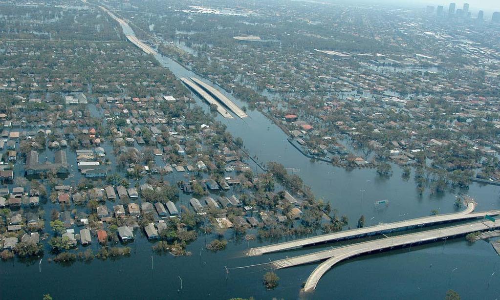
3 Introduction Integrity and reliability of flood-control infrastructure (levees, earthen dams, etc.) are essential components of homeland safety Aging and deteriorating National flood-control infrastructure (ASCE's 2009 Report Card: A grade of D to dams and a grade of D - to levees) Example of potential impact: Failure of levees during hurricane Katrina (2005) led to catastrophic flooding of New Orleans

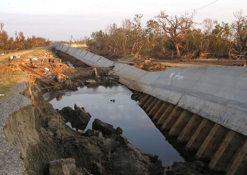
4 Motivation Aerial Photograph of the 17th Street Canal Breach (Looking South, courtesy of IPET)

5 New Orleans Before Katrina

6 New Orleans During Katrina
7 Motivation
8 Motivation
 Focus on components Provides Limited damage or weakness detection capability Inconclusive levee health assessment Limited predictability of overall system")
9 Current State-of-the-Art Levee health assessed on visual inspection Surface information (incomplete) Mostly qualitative An infrequent event (weekly to monthly to annually to every few years) Focus on components Provides Limited damage or weakness detection capability Inconclusive levee health assessment Limited predictability of overall system performance

10 Project Goals
11 Team Rensselaer Polytechnic Institute M. Zeghal (Project leader, Health assessment) T. Adoun (Field sensor development, Field monitoring) B. Yazıcı (Satellite remote sensing) Geocomp A. Marr (Field instrumentation, Monitoring Strategies, Data mining and decision tools) D. Ha (Field instrumentation, Monitoring and Data acquisition) Measurand (Contractor) L. Danisch (SAP sensors) J. Bond (GPS sensors)
12 Radar Remote Sensing Team (B. Yazıcı, C. Yanik, L. Jia, post-doc?) Objectives Monitor large areas of levee system (10s of sq. kms) using INterferometric Synthetic Aperture Radar (InSAR) Polarimetric Synthetic Aperture Radar (PolSAR) Estimate deformation in levee structures with subwavelength accuracy Obtain meter/pixel resolution for the observed area Estimate near surface moisture content


13 Interferometric SAR (InSAR) Generates surface deformation and digital elevation maps using two or more SAR images Interference fringes follow the topography One cycle of color represents 1/2 wavelength of path difference Image courtesy of NASA Image courtesy H. Zebker
14 Challenges in InSAR Lack of coherence due to geometric and temporal decorrelation and atmospheric effects Geometric decorrelation Satellites must be as close as possible to the same orbital position when the images are acquired over time Temporal decorrelation Movement of the scatterers or temporal change in the dielectric properties of the scatterers Vegetation grow Change in soil moisture, agriculture or snow cover Atmospheric effects Change in the speed of light, dispersion. Change in temperature, pressure, water vapor Sparsity of temporal data

15 New Orleans High rates of subsidence. Large sections of MRGO levee were breached during Katrina Map showing rate of subsidence for permanent scatterers in New Orleans and vicinity during using RadarSAT-1 data. Courtesy of T. Dixon, Nature 2006
 models")
16 Polarimetric SAR Deals with full vector nature of polarized electromagnetic waves Reconstructs a 2-by-2 matrix for each point on the ground Study the polarization matrix to extract Textural fine structure, scatterer orientation, shape, material constituents Can estimate soil moisture content when combined with auxiliary information Soil vegetation atmosphere transfer function (SVAT) models improve moisture estimation
17 Radar Satellites ERS1 & ERS2 RADARSAT-1 ENVISAT Sentinel 1 Sentinel 2 RADARSAT-2 RCM Constellation ALOS-PALSAR SAOCOM TerraSAR-X Tandem-X CosmoSky-Med Constellation
18 InSAR Processing Obtained access to historic SAR data achieves WInSAR, GeoEarthScope, Alaska SAR facility Using open source platforms to read in data ERS-1, ERS-2, ENVISAT, ALOS, RadarSAT-2 Evaluating historic InSAR data Evaluating technology from commercial satellites Will start acquiring and processing new data
19 Team Local Field Monitoring Tarek Abdoun & Victoria Bennett (RPI) Lee Danisch & Jason Bond (Measurand) Allen Marr & Da Ha (Geocomp) Local Monitoring Systems Shape-Acceleration/Pore Pressure Arrays GPS (enhanced resolution at low cost) Objectives Develop and implement advanced SAP & GPS monitoring systems at low cost Measure surface and in ground levee response with high resolution

 Sensor U B")

20 Shape Acceleration Pore Pressure (SAP) Sensor U B N Gravity U B U N U B N B N 20

21 Highway Landslide: Case Study River, ~SSW Measurand SAA MNDOT_1
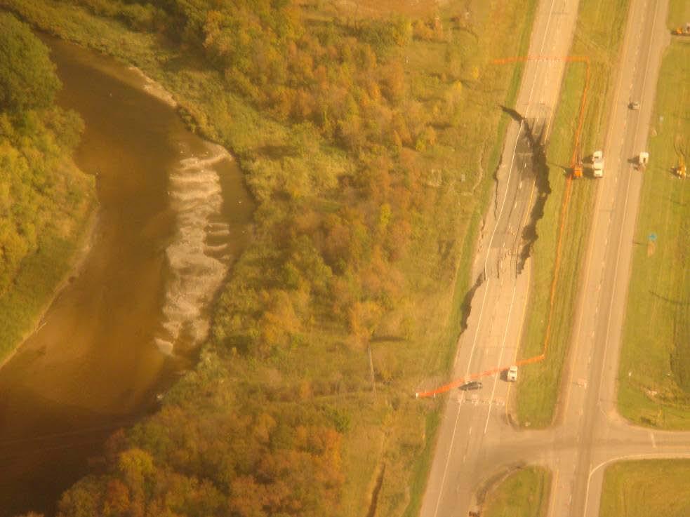

22 Highway Landslide: Case Study


23 Field Monitoring: GPS Development 23 GPS R&D Option: Provide Highest Accuracy at Lowest Cost 1. Identify lowest cost geodetic quality receivers 2. Develop algorithms to provide: i. High accuracy long term updates Goal: 1-2 mm in 24 hrs ii. High accuracy real time updates Goal: < 10 mm in 1 hr
24 Team Health Assessment M. Zeghal and V. Mercado (RPI) A. Marr (Geocomp) Objectives Integrate and analyze data from different sources within a computational levee model Provide an assessment of the health of levee: Local and global scale Provide adequate and reliable information and decision aids for public safety professionals and government
25 Health Assessment Approach Global health assessment and identification of critical and degrading segments using A calibrated global scale baseline model InSAR and PolSAR measurements A priori or engineering knowledge and site information Installation of SAP arrays and GPS at critical segments Local health assessment of critical segments Updated assessment of global health status Global and local health status reassessed when new measurements are made (following rain storms, flood, tides, and tremors, as well as traffic loads, aging, consolidation and creep).
26 Conclusion Exciting and important research at the right time Unrelated technologies have evolved into reliable and complementary data sources Strong need for fusion of multiple sensory data, data collection at both local and global scales, computational models for levees, use of a priori information Integration of information in a way that will lead to simple and reliable guidance to aid decision makers to make the right choices. Potential for many other applications