On the Road to Innovation
|
|
|
- Silas Morgan
- 5 years ago
- Views:
Transcription


1 On the Road to Innovation The fully integrated solution for the Laser Mapping and the Pavement Surface Inspection PAVE-SCANNER Laser Mobile System PMS-SIT Software Application Prague, Oct ing. Augusto Burchi - burchi@sitecoinf.it

2 SITECO Informatica Founded in 2000 as a software house, focused on GIS and RDBMS, dedicated to Road networks mapping and asset management; In 2005, Siteco started developing its MMS technology, by surveying more than km In 2012 Siteco introduced its turnkey MMS Road-Scanner3 and in 2014 the Road-Scanner4 systems, distributed worldwide. Since 2015, system and software unit of the Gavio group, one of the most important financial and construction groups in Italy, reported in the Milan Stock Exchange company list.


 EXPROPRIATION MANAGEMENT")
3 SOFTWARE Solutions ASSET MANAGEMENT Sign, Permits, Infrastructure works PAVEMENT MANAGEMENT SYSTEM Road and Airport Pavement Analysis Maintenence Management Plans RAIL MANAGEMENT Analysis of the geometry and the interferences of railroads ACCIDENT MANAGEMENT Monitoring and production of ISTAT reports (Regions of Emilia Romagna and Liguria) EXPROPRIATION MANAGEMENT Administration management Project management


4 PAVE-Scanner The FIRST 360-degree infrastructure and pavement surface inspection system available on the market
5 Laser Mobile Mapping + LCMS PAVE-Scanner comes from the full integration of the Pavemetrics LCMS vision system technology, onto the SITECO Road-Scanner hardware and software platforms The system includes a complete set of sensors to acquire all the infrastructure geometry and the pavement features at the same time The synchronization with the powerful inertial system allows perfect geo-referencing of all the acquired information
6 PAVE-Scanner : HARDWARE The Road-Scanner system is seamlessly integrated throughout the entire hardware implementation and software workflow, resulting in a totally turnkey commercial system. The latest LiDAR sensors from FARO, Riegl, Velodyne, Z+F, for 3D infrastructure measurement are fully supported. Wide variety of imaging cameras supported, including the popular Point Grey LadyBug 5 Top quality Inertial Measurement Systems from Applanix and IXBLUE
7

8

9
10 PAVE-Scanner : SOFTWARE Combined, the rich data and image information make an easy job of identifying and cataloging features in a flexible scalable geodatabase. All the features are Automatically Georeferenced and stored in the Geodatabase For the pavement defects, the feature extraction is fully automated thanks to the LCMS Software development kit For the road-side assets the extraction is managed through the Road-SIT Survey software suite, managing imagery and point clouds in the same environment
11 Post-processing LCMS data

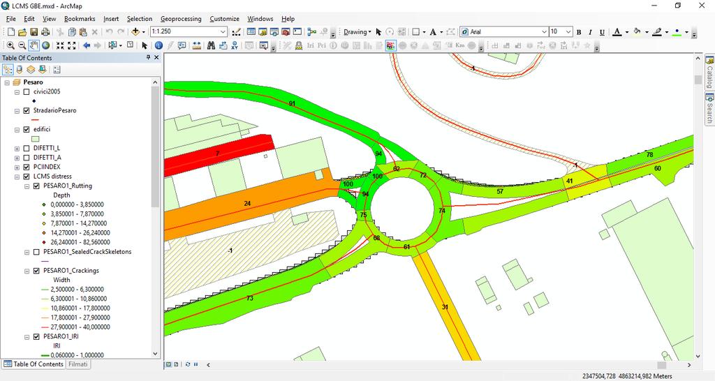
12 PMS and asset in the same environment


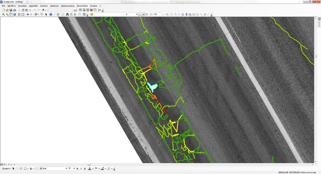
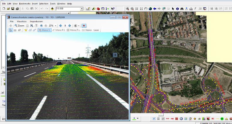
13 Examples of images and defects


14


15

16


17 Road-SIT AM Road Asset Management system Asset Management System


18
19 PMS-SIT The new PAVE-Scanner system has been developed together with the dedicated PMS-SIT software suite suitable for both road and airport pavements. The post-processing software allows a fully automated production of all the georeferenced data sets: spherical imagery, point clouds, hi-resolution pavement, 3D bit-maps, transverse profiles, rutting, IRI and Macrotexture data, cracking and other pavement defects, PCI (ASTM standards). Based on a GIS environment, PMS-SIT provides the contextual consultation of all the data sets and a full control of the maintenance status.


20 PMS-SIT Pavement Management System

 Already in use")
21 PMS-SIT Developed in compliance with the Italian National Authority for Civil Aviation (ENAC) Already in use in 3 Airports :


22 PMS-SIT A GIS application The application has a GIS interface, enriched with specific features for analyzing the data derived from the survey and the subsequent processing. All information is stored in an appropriately structured relational Microsoft SQL database. o o o o ESRI ArcGIS Plug-in Capable of processing the data collected with any Mobile Mapping Integrates data from functional and structural surveys Integrated with Asset and Facility Management


23 PMS-SIT Integration of historical and new survey data All the existing maps (orthophotos, CAD drawings, etc.) already available, and the data of previously carried out surveys (roughness, friction, bearing capacity, etc.) are inserted in the same topographicalgeodetic reference system. All of them are integrated with the results coming from the new surveys, suitably represented.


24 PMS-SIT Inventory of the defects surveyed with LRIS/LCMS The distresses have been first classified in a catalog according to the ASTM D6433/2003 specifications. The defects are geo-referenced by type. For each defect the system provides size and severity.


25 PMS-SIT Geometry, Pavement Data and others As first step, it s necessary to insert all General Data

26 PMS-SIT Inventory of the defects surveyed with LRIS/LCMS

.")

27 PMS-SIT Point Clouds In the case of surveys carried out with Mobile Mapping Systems, the application manages the point cloud and provides some automatic feature extraction (e.g. the severity for rutting or the depth of alligator cracking). The difference in altitude of the points of each cross section, is represented with a color ramp that enhances the deviations with respect to an average plane previously defined (3/4m).


28 PMS-SIT Decay Curves A decay curve is defined for each material and each functional or structural status index. The curve is automatically updated both in the simulation phase and as a result of the effective implementation of Maintenance activities.

29 PMS-SIT Definition of the Maintenance Activity Catalog In agreement with the Airport Postholder, various catalogs of Maintenance Activities can be defined. Each catalog allows the organization of the activities by type: Functional (maintenance) Structural (rehabilitation) Stopgap

30 PMS-SIT Definition of the Maintenance Activity Catalog Unit cost and effectiveness are defined for each intervention, in terms of benefits compared to the performance curves for each index. In the case of the PCI index, for instance, the system provides the list of defects that a specific activity can repair and any residual defect after processing. Localized repairs usually lower the severity degree without completely eliminate the defect, or transform into other defects such as patching.


31 PMS-SIT Calculation of the Maintenance Activity Costs After the intervention assignment to the Sample Areas or Section, the application performs the metric calculation of the necessary repair quantity, and estimates the total cost based on unit costs. The calculation of the repair cost may also include any extra costs (ex. sign remaking)


32 PMS-SIT Decision Support Tool The application provides technical data on the effectiveness of the activity carried out, in terms of type and number of solved defects.

, and structural activities (residual life")
33 PMS-SIT Manual assignment of the activity and simulations The application performs simulations on the effectiveness, distinguishing between functional activities (PCI value recalculation), and structural activities (residual life recalculation).


34 PMS-SIT Support Tool for the Activity Management PMS-SIT is also used to define timing, process states, operators involved in the activities. Thanks to the features provided by ArcGIS, it is possible to represent and immediately view the activities that have been planned, completed or under execution. It is also possible to view the activities on the costs or the execution technology. The software also allows the management of ordinary activities: daily activities or inspections are stored in the database in order to have a historical view. Finally, the system includes facility management functions.


35 PMS-SIT Definition of the Activity Priorities Starting from the definition of the index that determines the priority, usually the PCI value, PMS-SIT provides the list of areas already represented in a graph, according to color ramps. By activating the calculation of the Homogeneous Section, PMS-SIT provides the min. area of intervention
 Budget")
36 PMS-SIT Optimization Algorithms 1. For the selection of the activity scenarios the following optimization techniques and criteria have been adopted: Network status (illimited budget) Budget minimization Maximization of the benefit/cost ratio 2. Selection of the area (set of branches or sections) that will be analyzed

37 PAVE-SCANNER + PMS-SIT For more information, write to burchi@sitecoinf.it