Unified service, asset and work management processes in a spatial environment delivers new levels of efficiency
|
|
|
- Judith Morton
- 5 years ago
- Views:
Transcription
1 Unified service, asset and work management processes in a spatial environment delivers new levels of efficiency 7 October 2013 Bouke Spoelstra
2 Benefits of Spatial Context - GIS software creates, organizes, maintains, analyses and visualizes information related to location. Proximity- Geospatial data can help us understand the physical relationships among assets, and help reduce costs by enhancing decision-making Visualize Trends - Analysing and visualizing geospatial patterns can help identify trends and predict future events with greater accuracy Location - Track the locations of assets over time supporting compliance with governmental guidelines Efficiency - Geospatially enabled asset and service management systems better support customer service, work order management, emergency (outage) response, and mobile dispatch
3 We are all spatially enabled Smart phones: Garmin, Tom Tom or other navigation tools Web based tools: Google Earth, - Maps, Bing Maps, Yahoo Maps Municipal GIS Applications: ESRI/ArcGIS, PostGIS, Google, etc The challenge is to lever Spatial across business processes.
4 KPI s for Field Service Organisations Aberdeen Group is a business research organisation: Field Service benchmarking sample of 140 companies Evaluation Criteria: Best in Class = top 20% of the performance scorers All others = remaining 80% of performance scorers Key metrics used to Identify best in class Ability to meeting response times force utilisation First Time Fix Year on Year increase in productivity Field service technician is the face of the organisation

5 Strategic Initiatives of the Best in Class


6 Utility Solution Architecture Management Investment Planning Analytics Analysis Analysis Investment Programs Maintenance Rules History Customer Service Routine Generation Condition Records Mgmt Inspection & Routine Maint. Project Mgt Project Mgmt Project Status Service Customer Service Service Status Trouble Calls Outage Status Repair Real-Time Systems Outage Mgmt Attributes Network Events As-Designed Network Model SCADA / EMS Customer Data Value Plant Accounting Finance & Accounting Actual Payments Actual Labor Property Units As-Built Facilities and Field Data Follow-up Initiation Management Unplanned Initiated Compatible Units (CUs) CUs Existing Facilities GIS Changed Facilities HR Payroll Back-Office Supply Chain Materials Mgmt Contract Mgmt Actual Materials Time Entry Actual Contractor Actual Labor Completion Details Reporting & Closing Scheduled Mgt. Data Status Mgmt & Tracking Mgt. Data Scheduling Mgt. Data Material Status Planning & Estimating Planned Material Reservations Designs & As-Builts GL Accounts CUs to Design Spatial Systems Billing Requests Graphic Design Finance & Accounting Back-Office Mobile Data Field Recording GIS Data Details Mobile Network Details to Dispatch Dispatch Crew Configuration Crew Composition Resource Management Forecast Capacity Planning & Forecasting Materials Mgmt Re-Order Requests Purchase Requests Supply Chain Procurement
7 Challenge 1: Information silos Register Call Desk Log Spatial (GIS) SCADA Financial System register Account holders Supply Chain
8 Challenge 2: Modelling s are usually defined in one of the following methods: Financial asset register (ERP / Excel) & position identified but no Spatial context exist & static GIS focused asset model Location identified but limited Management Enterprise Management model Location,, supports Operations but lack Spatial context


9 The Ideal Environment Unified solution for: Service Management Management Management GIS Visualization Service Management Data Enrichment Financial Register Account Holders Scada incidents HR Systems Other Management Management GIS Visualization


10 Web Services Technology Client Web Browser DHTML JavaScript / DoJo Interface to REST API Interface to Geodatabase Web Server Service, & Mngmt Servlet AMD Objects HTTP REST API JS / DoJo ArcObjects Published Map, Data, GP Services GIS Server Web Server Application Server Application Server EAM Geodatabase 13

11 Register Enriched through Spatial & EAM


12 Follow the Business Process: Capturing Service request Register Request Search Hierarchies/ Drill down Filter for correct street or ERF

13 Spatial View of Planned & Corrective

14 Proactive Scheduling Yield Preventive Strategy


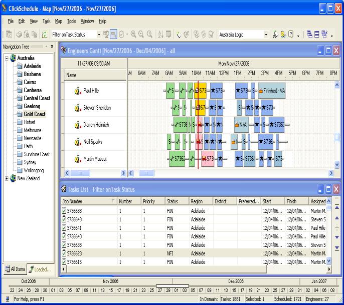


15 Visual Dispatching, Tracking & Tracing a key enabler


16 2 x Clicks


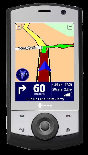
17 Location Direction Speed

18 Field Service Information Strategies for 2013

19 Thank You