Migrating 20-years of Spatial Data. The Knoxville, Knox County, Knoxville Utilities Board (KGIS) Experience
|
|
|
- Lewis Gilmore
- 5 years ago
- Views:
Transcription
")
1 Migrating 20-years of Spatial Data and Applications to a Modern GIS The Knoxville, Knox County, Knoxville Utilities Board (KGIS) Experience
2 KGIS Knoxville Knox County Knoxville Utilities Board Knoxville, Knox County, Knoxville Utilities Board GIS (KGIS)
3 M2E Project Objective - design, construct and implement an enterprise GIS solution to support the spatial information needs of KGIS member agencies & the public. Migrating GIS applications and data from Intergraph MGE GIS platform to ESRI ArcGIS platform.
4 M2E Tasks 1. Project Management 2. Business Process Analysis 3. System Requirements 4. System Architecture Planning 5. Database Design and Data Migration 6. Application Development 7. System Deployment 8. Post-deployment Support and Warranty


5 Project Management Five major stakeholders KGIS, City, County, MPC, KUB Prime contractor (CH2M HILL) with plus 4 subcontractors ESRI Sidwell Company RAMTeCH Corp. University of Tennessee 3-year schedule 1,000+ activities Activity-level cost control tool
6 Project Charter 5 Organizations 100+ Participants i t 15 Departments Property Assessor Public Works Engineering Addressing Register of Deeds County Trustee ss Office IT Police/Sherriff Fire Planning Health Utilities (electric, gas, water, sewer) Others


7 Business Process Analysis Business process interviews conducted 80 hours of interviews Over 60 participants Organized by department 100+ processes documented Document existing conditions Interaction between departments and agencies External systems that t must interact t with GIS Identify process deficiencies and suggest enhancements
8 System Requirements 856 requirements for 25 applications Captured during interviews


9 System Architecture Solution plan that addresses system requirements Document users/audience Software solution Data Management Hardware, backup, recovery Security Network Recommended 17 applications


10 IT Infrastructure to Support System
11 System Architecture Goals Standardize on Oracle Consistent with stakeholder agencies All content portal and map Single system for all editors and viewers internal and external audiences Single sign-on capability through integration with active directory trusted external domains Decision to maximize use of web mapping application over desktop


12 Database Design Source Data Inventory Spatial, tabular & raster data collected during 20 years of operations Landbase, streets, signs, parcels, zoning, utilities Microstation, Oracle, various ESRI formats 300 GB 11,755 Files 96 Groups 580 source MGE Feature Types 350 source SDE Feature Classes Miscellaneous DBs

13 Database Design Target Database Design ESRI Geodatabase 600+ feature classes Industry standard models customized to existing customer data & requirements Leverage ESRI Oracle ST_Geometry data type Logical Design MS-Visio and CASE tool Graphical representation of database design Efficient design technique Physical database built from XML export from Visio
14 Data Migration Conducted in five phases Pilot Critical data sources Edited frequently Final migration must be executed quickly Entire geographic extent of data Phase 1: static data Planimetric, topographic, etc. Phase 2 Archive data sets (not used in production) Phase 3 Addressing and Cadastral (parcels) Migration schedule coordinated with data maintenance application roll-out Phase 4 City sign, ward, storm utility, etc. Migration schedule coordinated with data maintenance application roll-out
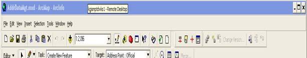
15 Data Maintenance Applications Built on the ESRI ArcGIS 9.2 Desktop platform Configured Task Assistant to guide user through application workflow MX Edit for forms-based editing Custom ArcObjects plugins to automate data entry and data integrity checks Used by primary data editors Approximately 40 spatial data editors


16 Data Maintenance Applications
17 Data Maintenance Applications Address data maintenance Property data maintenance Sidwell Company Parcel Builder Sbdiii Subdivision dt data management using COGOt tools Sign data maintenance Outfall data maintenance SPAP Permit data maintenance Planning Commission agenda case maps application
18 Reverse Migration Application Migrate data maintained in new ESRI Geodatabase format to the legacy MGE format Ensure continued use of legacy applications during transition SAFE Software FME with custom wrapper


19 Web Mapping Applications Multi-component web mapping solution Administer map content and security Manage user profile Map navigation Spatial data queries and reporting Metadata t access Geocoding Measure, Selections, and Markups Printing MORE!


20 KGIS Portal Home Page Administrator manages map content same as non-map content through portal. Agency (domain) users automatically authenticated. Portal provides Portal provides access to all content.


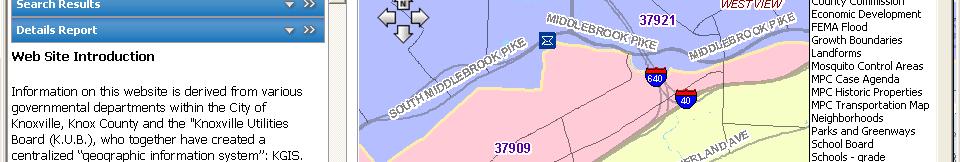
21 Web Map Viewer Change Map Themes Console: -Results -Tasks -Contents Address, Parcel, or Owner quick search MAP Toolbar


22 Quick Access to Property Information Search Results Property Details -Address info -Owner info -Parcel info -School zones -Voting info


23 Owner Card Report Presents historic ownership and owner mailing address


24 Address Search Builder Address Search Builder allows users to find a valid address.


25 Map Content Organized in Themes Zip Codes Map Theme Base Map Theme


26 Share Your Map! a friend or colleague a URL that will open the map to the same location and with same content
27 Tasks Advanced tasks -Select tools -Markup tools -Print -Advanced address tools


28 Users Can Personalize their Maps Using Profile Settings My Profiles to store y personal -Spatial Bookmarks -Map Themes
29 Deployment Required close collaboration between KGIS and CH2M HILL KGIS responsible for hardware and network deployment Jointly deployed custom applications Training admin training user training in classroom, individual, and open-house forums
30 Lessons Learned Communicate with stakeholders early and often Open and frequent communications Maximize use of COTS tools Sidwell Parcel Builder ESRI Task Assistant Don t drink the technology kool-aid Leverage only a couple new things at one time Create seamless team with contractor Leverage each members specific expertise
31 Other KGIS Presentations Developing a Comprehensive Local Government Web GIS Solution Wednesday July 15 1:30PM - 2:45PM Automated Change Notification Keeps Everyone in the Know! Thursday July 16 1:30PM - 2:45PM