DelDOT s. Online Resource. Information. For. Network. Mapping
|
|
|
- Patrick Chandler
- 6 years ago
- Views:
Transcription
1 DelDOT s Information Network For Online Resource Mapping
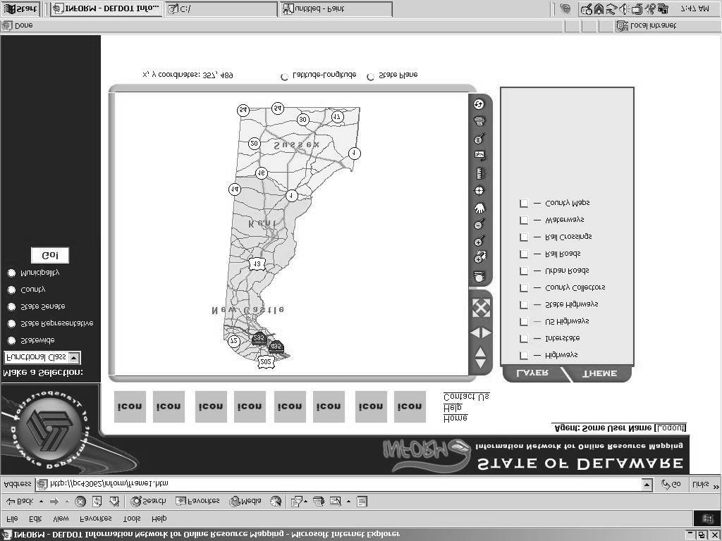
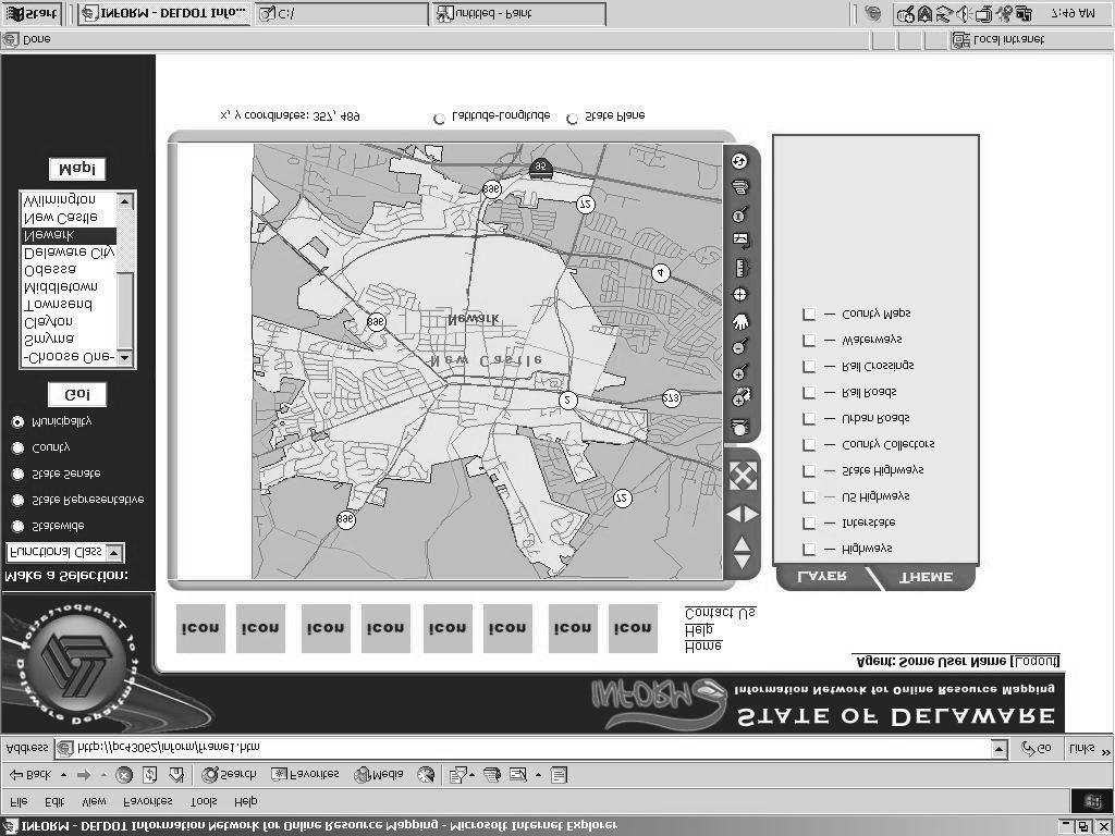
2 What is INFORM? Information Network For Online Resource Mapping DelDOT s s Web-based based GIS Application Centralized Source for DelDOT GIS Data Release Date May 2004
3 What will INFORM do? Provide GIS Information via the Intranet Provide Consolidated Presentation of Spatial Data Provide Consistent and Standard Map and Report Formats Enable Ad-hoc Queries Provide Critical Tool for Master Scheduler
4 Benefits of INFORM Improve/Quicken Decision Making Easier Access to Data Reliable Data Improve Consistency in Responses Public State Agencies DelDOT Improve Coordination between Geographically Distributed Staff and Functions Reduce Cost of GIS Software Licensing
5 The Information Network for Online Resource Mapping (INFORM) is: A data repository that organizes, integrates, and disseminates a wide variety of DelDOT data An Intranet GIS application that is frequently and effectively used by DelDOT personnel to query, view, and print geospatial, tabular, and other information relevant to their jobs
6 INFORM Strategic Goals Establish Access to Data Identify the Authoritative Source Ensure Data Currency Identify Data Access Security Identify Comprehensive Business Requirements Include all Divisions Document Data and Functional Requirements Prototype Application Deliver Initial System Quickly Solicit Feedback Document and Publicize Success Stories Maintain Application Coordinate with Other Initiatives Expand as Business Requirements Change
7 INFORM Core Team Don Burris Project Manager (OIT) Brian Smith Project Leader (OIT) Jennifer Cajthaml (Pavement) Temple Carter (Real Estate) Mike deltufo (OIT) Hugo Dreibelbis (Design Support) Bernie Gilbert (Planning) Kevin Gustafson (Planning/Road Inventory) Sanjay Kumar (OIT) Chad Lauderbaugh (Planning) Glen Miller (Bridge) Vince Rucinski (Planning)
8 Sections Interviewed Bridge Design Bridge Management Canal District Contract Administration Design Support Financial Investments Maintenance and Operations North District OIT Pavement Planning Preconstruction Real Estate Road Design Road Inventory Traffic (TMC)
9 INFORM Technologies Oracle Database Apache Web Logic J2EE Compliant ESRI ArcIMS ArcSDE
10 Phase I Deliverables COUNTY MUNICIPALITIES LEGISLATIVE DISTRICTS MAINTENANCE DISTRICTS MAINTENANCE AREAS CENSUS BLOCK DATA CENTER LINE TRANSIT RAIL LINES WETLANDS DIGITAL ORTHOPHOTOGRAPHY Version 1.0 (May 2004) PROJECTS Pavement Projects by Type Capital Projects by Work Status Capital Projects by Work Type Capital Projects by Year CTF Projects by Year CTF Projects by Work Type CTF Planned Projects CTF Projects Under Construction Active Work Orders (from Maximo)
11 Phase I Deliverables Version 1.0 (May 2004) - Continued ROAD INVENTORY Functional Class Maintenance Responsibility Number of Lanes Surface Condition State, Suburban, and Municipal HIGHWAY SAFETY IMPROVEMENT PROGRAM HSIP Sites by Year AVERAGE ANNUAL DAILY TRAFFIC BRIDGES Sufficiency Rating PAVEMENT CONDITIONS Overall Pavement Condition (OPC) Pavement Condition
12 Phase I Deliverables Version 1.1 (Fall 2004) ENVIRONMENTAL DATA Archaeological/Historical Wetlands PROJECTS Capital Projects by Work Status Capital Projects by Work Type Capital Projects by Month STORM WATER Storm Water Pipes by Construction Material Storm Water Manholes by Construction Material
13 Phase I Application Features Normal Mapping Functions Interactive Legend Thematic Maps for Data Sets Ability to Query by: Business Group Sub-business business Group Theme Single Road Road Name Data Overlays At-a-Glance User Comments Print Layout Tool Online Help Query Result Reports Query by Selected Area Data-Driven Driven Map Viewing Commands CTF Security

14 INFORM Splash Screen
15 Preliminary Workflow
16 Preliminary Workflow
17 Functionality Planned for Future Phases Additional Data Layers Additional Reporting Export Reports Video Logging Video Pipe Inspection Integration with ITS Cameras Routing GeoCoding Statewide Arc Services Link Road Segments to Design Documents Online Metadata Tool Tips for Map Features Links to Other Applications Graphing and Charting Zoom to Intersection Queries using Parameters Data and Maps Administration Save User Preferences
18 Future Functionality? Public Internet Access First Responder Areas Transit Ridership Data Link HSIP Site Documents HPMS Data Reporting Link Digital Documents to Mapping Layer ANYTHING ELSE THAT CAN BE DREAMED!
19 INFORM Summary Quick Release - May 2004 Centralized Source for DelDOT GIS Data Reliable, Easy-to to-use, Web-based based GIS Application Transportation Information at the Users Fingertips Multiple Phases Allowing Additional Functionality

20 Questions?? Intranet? Info Systems? GIS INFORM Project
Location-driven business at the
 Location-driven business at the Utah Department of Transportation Jeff Saunders Farallon Geographics, Inc. Senior Geodatabase Developer Dan Paske Utah Department of Transportation Oracle DBA Today s Goals
Presented by John Hudler Geospatial Group Leader Office of Transportation Data Georgia Department of Transportation
 Presented by John Hudler Geospatial Group Leader Office of Transportation Data Georgia Department of Transportation Collection, Quality Assurance and Reporting of the States roadway and transportation
Enterprise Access to Traffic Information. Michael Bish Matt Hiland Tony Pietropola
 Enterprise Access to Traffic Information Michael Bish Matt Hiland Tony Pietropola Traffic Information Access (TRINA) Background Project Objectives Approach Outcome TRINA Background Traffic information
One Maryland One Centerline. GIS-T 2014 May 7, 2014
 One Maryland One Centerline GIS-T 2014 May 7, 2014 Current Road Centerlines in Maryland SHA maintains a statewide centerline Supports HPMS program Represents state and local roads Capturing dual carriageways
April 21, 2015 GIS-T Conference
 April 21, 2015 GIS-T Conference 1 Introductions Don Burris Vice President, Government Solutions Certified GIS Professional Raghunath Madduri Lead Solutions Architect & Project Manager ESRI Certified Enterprise
Esri Roads and Highways An Introduction. Nathan Easley Rahul Rakshit
 Esri Roads and Highways An Introduction Nathan Easley Rahul Rakshit Roads and Highways Linear Referencing for the Transportation Enterprise GIS-enabled LRS platform LRS management LRS editing & maintenance
APPENDIX A: SHORT-TERM PROJECT DEPLOYMENTS
 APPENDIX A: SHORT-TERM PROJECT DEPLOYMENTS Page 1 of 15 ST-01: I-95 ITS DEPLOYMENT (DE STATE LINE TO AIRPORT) PROJECT DESCRIPTION AND SCOPE: Project will address gaps in ITS device coverage on I-95 from
Request for Proposals
 City of Posted: June 5, 2017 Published: June 7, 2017 Request for Proposals GIS-BASED ASSET MANAGEMENT SOFTWARE The City of Bonney Lake is requesting proposals for acquisition and implementation of asset
NYSDOT s Over Dimensional Vehicle Prescreening Tool
 NYSDOT s Over Dimensional Vehicle Prescreening Tool Using Enterprise Data to Support Oversize Vehicle Permitting Kevin Hunt GIS-T T 2008 NYSDOT s Special Hauling Permits Responsible for evaluating up to
City of Fairfield GIS Management Portal Implementation
 City of Fairfield GIS Management Portal Implementation Shakeel Ajam GIS/Software Dev. Manager City of Fairfield, CA Charlie Crocker Vice President Farallon Geographics, Inc. Today s Goals Present City
Process to Identify High Priority Corridors for Access Management Near Large Urban Areas in Iowa Using Spatial Data
 Process to Identify High Priority Corridors for Access Management Near Large Urban Areas in Iowa Using Spatial Data David J. Plazak and Reginald R. Souleyrette Center for Transportation Research and Education
Esri Roads and Highways Solution Overview. Eric Floss Transportation Practice Manager
 Esri Roads and Highways Solution Overview Eric Floss Transportation Practice Manager Agenda Esri LRS Solution Briefing Advanced Linear Referencing Support User Interface Experience Open Discussion GIS
Creating Master Data Sets Build it once, use it a bunch
 Creating Master Data Sets Build it once, use it a bunch David Blackstone Office of Technical Services Dan Casey Chief Business Development Officer What When Why How Who What When Master Data Set Why How
Migrating 20-years of Spatial Data. The Knoxville, Knox County, Knoxville Utilities Board (KGIS) Experience
 Experience") Migrating 20-years of Spatial Data and Applications to a Modern GIS The Knoxville, Knox County, Knoxville Utilities Board (KGIS) Experience KGIS Knoxville Knox County Knoxville Utilities Board Knoxville,
Migrating 20-years of Spatial Data and Applications to a Modern GIS The Knoxville, Knox County, Knoxville Utilities Board (KGIS) Experience KGIS Knoxville Knox County Knoxville Utilities Board Knoxville,
NOMINATION FORM. Florida Department of Environmental Protection
 NOMINATION FORM Title of Nomination: Project/System Manager: Job Title: Agency: Department: WebPoint John Willmott Chief Information Officer Florida Department of Environmental Protection Bureau of Information
OPEN DATA & PROJECT TRACKER. Michael Chamberlain TPP, Data Management
 OPEN DATA & PROJECT TRACKER Michael Chamberlain TPP, Data Management October 11, 017 Table of contents 1 People 3 Attributes 4 3 Locations 5 4 Systems 6 5 Reports 7-8 6 Applications 8-13 7 Closing 14 Data
Building West Virginia DOT s Geospatial Capabilities:
 Building West Virginia DOT s Geospatial Capabilities: GIS Web Portal And Straight-line Diagram Application Current Status, Upcoming Enhancements, and Integration Marshall Burgess, WVDOT Don Kiel, GeoDecisions
GeoSpatial Enablement Strategy Appendix 6 Existing Business Systems and Workflows
 GeoSpatial Enablement Strategy Appendix 6 Existing Business Systems and Workflows February 18, 2005 Prepared for KDOT by Intergraph Mapping and GeoSpatial Solutions Table of Contents 1.1 Comprehensive
A web GIS Application for Project Tracking and Production Monitoring
 A web GIS Application for Project Tracking and Production Monitoring Xinsheng (Kevin) Zhang & Rob Tubello EarthData International 7320 Executive Way, Frederick, MD 21704 Abstract Using ESRI ArcIMS, ArcSDE,
NCHRP 8-87 Implementing GIS for Transportation Asset Management. 10 th National Conference on Transportation Asset Management April 28, 2014
 NCHRP 8-87 Implementing GIS for Transportation Asset Management 10 th National Conference on Transportation Asset Management April 28, 2014 Workshop Agenda 1) Introductions and Overview 2) Implementing
INDUSTRY. Transportation
 INDUSTRY Transportation Solutions Keeping people and products moving safely and efficiently In a world of constant change, keeping people and products moving safely and efficiently is a complex, unrelenting
Michigan Transportation Asset Management Council & Center for Shared Solutions
 Roadsoft Users Conference of the US 2016 Michigan Transportation Asset Management Council & Center for Shared Solutions Rog Belknap, TAMC Coordinator Mark Holmes, DTMB Dave Jennett, CSS Melissa Carswell,
Florida Department of Transportation 605 Suwannee Street Tallahassee, FL
 RICK SCOTT GOVERNOR Florida Department of Transportation 605 Suwannee Street Tallahassee, FL 32399-0450 MIKE DEW SECRETARY REQUEST FOR INFORMATION (RFI) from the Florida Department of Transportation INTRODUCTION
Topics. Traffic Signals and Safety
 Topics Traffic Signals and Safety TSAMS (Traffic Signal Asset management System) GLG-Green Light Go Program Traffic Signal Remote Communication Policy Automated Signal Performance Measures Unified Command
Project Update. Roads and Highways Implementation. Emiko Hori. West Virginia Department of Transportation
 Roads and Highways Implementation at WVDOT Project Update Emiko Hori Geospatial Transportation Information (GTI) Section Geographic Information System (GIS) Unit Agenda 1. Development History 2. Roads
Building and Maintaining Your Statewide Crossing Inventory
 Building and Maintaining Your Statewide Crossing Inventory 2015 National Highway-Rail Grade Crossing Safety Training Conference Arlington, TX 03 Nov 2015 www.jacobs.com worldwide Presentation Outline Inventory
Asset Management and Data Collection using Digital Video / GPS Data Extraction Techniques
 Asset Management and Data Collection using Digital Video / GPS Data Extraction Techniques TRB 6 th National Conference on Transportation Asset Management Kansas City, Missouri November 2, 2005 Presentation
Examination of GIS and Current Information System Plans and Responsibilities
 DCT 191 Examination of GIS and Current Information System Plans and Responsibilities By DAVID RACCA Center for Applied Demography and Survey Resear ch College of Human Ser vi ces, Education, and Public
Lake County Internet-based GIS tools
 Lake County Internet-based GIS tools This document highlights twenty-three Internet-based GIS tools that have been developed to provide information and tools that have greatly enhanced the productivity
TRB Webinar: Maintenance Practices for Traffic Sign Retroreflectivity
 TRB Webinar: Maintenance Practices for Traffic Sign Retroreflectivity Today s Presenters and Moderator Paul Carlson, Texas Transportation Institute at Texas A&M University, Paul-Carlson@tamu.edu Jim Ellison,
Keeping people and products moving safely and efficiently
 Solutions for Transportation 2 Keeping people and products moving safely and efficiently In a world of constant change, keeping people and products moving safely and efficiently is a complex, unrelenting
STATE OF ALASKA RFP NUMBER 2515H005 AMENDMENT NUMBER FIVE (5)
") STATE OF ALASKA RFP NUMBER 2515H005 AMENDMENT NUMBER FIVE (5) AMENDMENT ISSUING OFFICE: Department of Transportation & Public Facilities Statewide Contracting & Procurement P.O. Box 112500 (3132 Channel
STATE OF ALASKA RFP NUMBER 2515H005 AMENDMENT NUMBER FIVE (5) AMENDMENT ISSUING OFFICE: Department of Transportation & Public Facilities Statewide Contracting & Procurement P.O. Box 112500 (3132 Channel
Extending the Value of Maximo Solutions
 Extending the Value of Maximo Solutions Mobile, Spatial, and other technologies that extend support for asset and service management best practices Agenda Service Management World Tour The The purpose
Model Inventory of Roadway Elements (MIRE) GIS-T Annual Conference March 30, Robert Pollack FHWA
 GIS-T Annual Conference March 30, Robert Pollack FHWA") Model Inventory of Roadway Elements (MIRE) GIS-T Annual Conference March 30, 2011 Robert Pollack FHWA What is MIRE? Model Inventory of Roadway Elements Listing of roadway and traffic elements critical
Model Inventory of Roadway Elements (MIRE) GIS-T Annual Conference March 30, 2011 Robert Pollack FHWA What is MIRE? Model Inventory of Roadway Elements Listing of roadway and traffic elements critical
The New Age for Sewer Planning at the City of Los Angeles
 The New Age for Sewer Planning at the City of Los Angeles Mario Dimzon 1 * P.E., Fernando Gonzalez 1 P.E., Ali Poosti 1 PE, Adel Hagekhalil 1 PE, Erick Heath 2 P.E., Rajan Ray 2 P.E., Erin Breen 2 P.E.
NJDOT: Asset Management Strategies and Tools
 NEW JERSEY DEPARTMENT OF TRANSPORTATION NJDOT: Asset Management Strategies and Tools Wednesday, October 1, 2014 Afternoon Session (1:45pm 2:30pm) Presenters Michael Castaldo New Jersey Department Of Transportation
ESRI, GIS & the Telecommunications Enterprise: Solutions, Status and Vision. Kees van Loo Business Development Manager ESRI
 ESRI, GIS & the Telecommunications Enterprise: Solutions, Status and Vision Kees van Loo Business Development Manager ESRI Agenda Introduction Update ESRI in Telco Telecom GIS Architecture New Users: Telecom
ArcGIS for Transportation. Tom Brenneman, Gary Waters
 ArcGIS for Transportation Tom Brenneman, Gary Waters ArcGIS for Transportation A product for Esri s transportation customers A series of useful maps and apps focused on transportation Organized into modules
STATEWIDE TRAFFIC ANALYSIS AND REPORTING SYSTEM (STARS II)
") STATEWIDE TRAFFIC ANALYSIS AND REPORTING SYSTEM (STARS II) Transportation Planning and Programming Division (TPP) June 15th-17th, 2016 Planning Data & Analysis March 31, 2016 Overview: Why is STARS II
STATEWIDE TRAFFIC ANALYSIS AND REPORTING SYSTEM (STARS II) Transportation Planning and Programming Division (TPP) June 15th-17th, 2016 Planning Data & Analysis March 31, 2016 Overview: Why is STARS II
GIS based interactive Facilities Management Environment (IFaME)
") GIS based interactive Facilities Management Environment (IFaME) Vasanth KC 1, G.K. Viswanathan 2 1 GIS Consultant, NeST Information Technologies 2 Sr. GIS Consultant, NeST Information Technologies NeST
GIS based interactive Facilities Management Environment (IFaME) Vasanth KC 1, G.K. Viswanathan 2 1 GIS Consultant, NeST Information Technologies 2 Sr. GIS Consultant, NeST Information Technologies NeST
DATE: September 8, 2014 REPORT NO. PW Chair and Members Committee of the Whole Operations and Administration
 PUBLIC WORKS COMMISSION DATE: September 8, 2014 REPORT NO. PW2014-047 TO: FROM: Chair and Members Committee of the Whole Operations and Administration Geoff Rae, MBA, P.Eng. General Manager, Public Works
2017 Highway Safety Improvement Program Call
 2017 Highway Safety Improvement Program Call The Highway Safety Improvement Program (HSIP) is for highway safety projects that eliminate or reduce the number of fatalities and serious injuries on all public
Eating at the GIS Buffet. Yelena Kalashnikova Elizabeth Ervin Thebo
 Eating at the GIS Buffet Yelena Kalashnikova Elizabeth Ervin Thebo SCDOT GIS Office A small office of 13 staff some contractor some FT) Responsibilities include Maintaining geometry and key attribute information
From Consolidation to Centralization LUIS E. CARRASCO, PH.D. NORTH CAROLINA CENTER FOR GEOGRAPHIC INFORMATION AND ANALYSIS
 From Consolidation to Centralization LUIS E. CARRASCO, PH.D. NORTH CAROLINA CENTER FOR GEOGRAPHIC INFORMATION AND ANALYSIS Outline Address Points State efforts for address management consolidation 2009:
Supporting Transportation
 Maryland s egis Program: Supporting Transportation Professionals and the Public Maryland State Highway Administration GIS at Maryland State Highway Administration GIS falls under the Office of Planning
Mississippi DOT s s Approach to Image Distribution and Management. GIS-T Oklahoma City, April 5-8
 Mississippi DOT s s Approach to Image Distribution and Management GIS-T Oklahoma City, April 5-8 Overview THE PROBLEM(s) Solutions for THE PROBLEM(s) Project History - Phased Implementation Approach Phase
Updating Virginia s Statewide Functional. Brad Shelton, VDOT Chris Detmer, VDOT Ben Mannell, VDOT
 Updating Virginia s Statewide Functional Classification System Brad Shelton, VDOT Chris Detmer, VDOT Ben Mannell, VDOT July 18, 2013 What is Functional Classification Use of Functional Classification Today
The ipems MAP-21 Module
 The ipems MAP-21 Module Producing the information you need from the National Performance Management Research Data Set (NPMRDS) January 2015 Innovation for better mobility Use the ipems MAP-21 Module to
Enterprise GIS Defining A Path Forward
 Enterprise GIS Defining A Path Forward Background DOTD acquired topographic mapping responsibility for the state in 2010 by legislative authority Executive management sponsors GIS as enterprise endeavor
GeoDataShare -Spatial SOA CityMap Web 2.0 mapping
 GeoDataShare -Spatial SOA CityMap Web 2.0 mapping Mario Gouvea Director of Enterprise Spatial Technologies Department of Information Technology & Telecommunications City of New York November 2, 2006 New
NYSDOT Roadway Inventory. Both On and Off the State System
 NYSDOT Roadway Inventory Both On and Off the State System 1 2 NYSDOT Highway Data Services Bureau Highway Data Traffic Monitoring Pavement Data Inventory of public roads, incl. LHI Systems designations
Avitar Assessing System
 Avitar Assessing System The Avitar Assessing system is currently installed in more than 100 municipalities throughout New Hampshire. Our complete municipal assessing software system has the following features:
Performing Cost Effective Asset Management Inventories Utilizing GIS. Steve Tyler, Public Works Superintendent Mark Dumford, Consultant
 Performing Cost Effective Asset Management Inventories Utilizing GIS Steve Tyler, Public Works Superintendent Mark Dumford, Consultant Town of Atherton South San Mateo County 5 square miles Approximately
Using Random Samples to Assess Roadway Condition. Faith Johnson GIS Specialist, NCDOT
 Using Random Samples to Assess Roadway Condition Faith Johnson GIS Specialist, NCDOT North Carolina Highway System 79,600 miles of state maintained roads Interstate: 1,326 Primary: 13,736 Secondary: 64,522
FDOT State Safety Office History, Accomplishments & Planned FHWA Funded Efforts. Presenters: Kathryn Waters & Joseph Santos July 29, 2015
 FDOT State Safety Office History, Accomplishments & Planned FHWA Funded Efforts Presenters: Kathryn Waters & Joseph Santos July 29, 2015 Welcome & Introductions Name Organization Your Role & Responsibility
September Public Meetings. Developing a Blueprint for the Corridor
 September Public Meetings Developing a Blueprint for the Corridor Study Background Study initiated by the Commonwealth Transportation Board (CTB) and administered by VDOT in association with VDRPT. Addresses
The Evolution of Data. Mike Schwab Solutions Architect
 The Evolution of Data Mike Schwab Solutions Architect The data story Asset Management development over the years Potential benefits of Asset Management Next steps toward proactive Asset Management Case
Webinar Presentation Order and Timeline
 Webinar Presentation Order and Timeline Time (Central) Segment Duration Presenter Notes 11:02 am Intro/Welcome 3 mins Chris Francica General information and housekeeping while people are still logging
USGS NGTOC Business Systems. Scott Owens USGS - National Geospatial Technical Operations Center (NGTOC)
") + USGS NGTOC Business Systems Scott Owens USGS - National Geospatial Technical Operations Center (NGTOC) Agenda Responsibilities and Roles within NGTOC Business Systems Development Product Tracking System
+ USGS NGTOC Business Systems Scott Owens USGS - National Geospatial Technical Operations Center (NGTOC) Agenda Responsibilities and Roles within NGTOC Business Systems Development Product Tracking System
BASINS EXERCISE. 2) Select the Locate your Watershed webpage (located at:
 Select the Locate your Watershed webpage (located at:") BASINS EXERCISE Overview This exercise was created for the Fox-Wolf Watershed Alliance - Stormwater 2003 Conference. Funding was provided by the University of Wisconsin Sea Grant Institute and UW Land
BASINS EXERCISE Overview This exercise was created for the Fox-Wolf Watershed Alliance - Stormwater 2003 Conference. Funding was provided by the University of Wisconsin Sea Grant Institute and UW Land
Using Insights for ArcGIS to Explore and Understand Risk Analysis Results
 Using Insights for ArcGIS to Explore and Understand Risk Analysis Results Dave Veilleux GIS Workstream Manager, West Coast All rights reserved 1 1 COMPANY OVERVIEW Domain UPSTREAM MIDSTREAM DOWNSTREAM
10:00 AM Welcome, Introductions & Project Overview 10:15 AM ITS Architecture Overview
 Stakeholder Meeting February 10, 2016 Agenda 10:00 AM Welcome, Introductions & Project Overview 10:15 AM ITS Architecture Overview National ITS Architecture Terms and Concepts Regional ITS Architecture
Take Your CAMA to the Next Level
 ASSESSMENT Assessment Analyst Take Your CAMA to the Next Level A trend of new construction and increasing property counts across the country are placing greater expectations on assessment agencies than
Utilizing GIS to Manage Facilities and Municipal Assets. McMAHON CMOM WORKSHOP. Stacey Henk, GIS Analyst. Presentation Agenda
 Utilizing GIS to Manage Facilities and Municipal Assets Stacey Henk, GIS Analyst September 16, 2015 Presentation Agenda GIS - What is it? GIS Functions Why GIS for Managing Facilities & Municipal Assets?
Integrating Asset Management and Growth Planning Ontario West Municipal Conference London, Ontario November 20, 2015
 Integrating Asset Management and Growth Planning 2015 Ontario West Municipal Conference London, Ontario November 20, 2015 Presentation Outline 1. The City of Brantford 2. Asset Management Planning at the
Functional Requirements
 Missouri Department of Transportation Springfield Regional ITS Architecture Update Prepared for: Project ID: D8ITS-01 Missouri Department of Transportation Traffic Division MODOT DISTRICT 8 OFFICE M.O.
PennDOT s Road Closure Reporting System ( )
") PennDOT s Road Closure Reporting System ( ) Doug Tomlinson, P.E. PennDOT Bureau of Highway Safety and Traffic Engineering Nate Reck, Lead Developer GeoDecisions How RCRS Came About Originated by PennDOT
PennDOT s Road Closure Reporting System ( ) Doug Tomlinson, P.E. PennDOT Bureau of Highway Safety and Traffic Engineering Nate Reck, Lead Developer GeoDecisions How RCRS Came About Originated by PennDOT
Design and Operations and Management of GIS Workflows for Multi-utilities. Benoit Fredericque Senior Product Line Manager Geospatial Desktop & Mobile
 Design and Operations and Management of GIS Workflows for Multi-utilities Benoit Fredericque Senior Product Line Manager Geospatial Desktop & Mobile The Utilities Industry Is Changing Climate change and
EBOOK BIM ASSESSMENT GUIDE TAKE THE FIRST STEP TOWARDS CRAFTING A BIM IMPLEMENTATION PLAN
 EBOOK BIM ASSESSMENT GUIDE TAKE THE FIRST STEP TOWARDS CRAFTING A BIM IMPLEMENTATION PLAN Better understand your current conditions and business objectives THE IMPLEMENTATION OF BIM FOR INFRASTRUCTURE
Transit GIS Applications in Fairfax County, Virginia
 Journal of Public Transportation 41 Transit GIS Applications in Fairfax County, Virginia Wenyu Jia and Brendan Ford Fairfax County Geographic Information Services Abstract The Fairfax County Department
Using Arc Hydro in Florida
 Using Arc Hydro in Florida Alan Foley, P.E. September 8, 2008 Introductions Project drivers What is Arc Hydro? Arc Hydro in Florida The beginnings Overview Innovations and evolution Considerations What
Montana DOT Strategic Enterprise Architecture Presentation to 2016 IHEEP Annual Conference. September 12, 2016
 Montana DOT Strategic Enterprise Architecture Presentation to 2016 IHEEP Annual Conference September 12, 2016 Introductions Jack Dartman Application Development Supervisor and Enterprise Architect MDT
COUNTY OF SUFFOLK STEVEN BELLONE SUFFOLK COUNTY EXECUTIVE DEPARTMENT OF PUBLIC WORKS
 CEE BS, Fulltime (3 positions) Posted 1/30/2017 COUNTY OF SUFFOLK STEVEN BELLONE SUFFOLK COUNTY EXECUTIVE DEPARTMENT OF PUBLIC WORKS SUFFOLK COUNTY IS AN EQUAL OPPORTUNITY / AFFIRMATIVE ACTION EMPLOYER
The Power of Geospatial Visualization for Linear Assets Using Oracle Enterprise Asset Management
 The Power of Geospatial Visualization for Linear Assets Using Oracle Enterprise Asset Management Sudharsan Krishnamurthy (Kris), Sr. Director, Oracle E-Business Suite Oracle America Inc. Jan 27, 2016 Oracle
Detailed Report Activities & Tasks Jun 2 nd 2016 For CAGIS Policy Board
 Cincinnati Area Geographic Information System Detailed Report Activities & Tasks Jun 2 nd 2016 For CAGIS Policy Board CAGIS Administrator Raj Chundur Inaugural Cincinnati City Manager's Award for Excellence
GIS-T Symposium 2017 PennDOT s Maintenance-IQ: How Has It Been Used to Better Operations
 GIS-T Symposium 2017 PennDOT s Maintenance-IQ: How Has It Been Used to Better Operations Matthew Long, GIS and Transportation Planning Specialist PennDOT Office of Planning and Programming Nate Reck, Gov
BIM for infrastructure, Paul King Bentley Systems 2016 Bentley Systems, Incorporated
 BIM for infrastructure, Paul King 1 WWW.BENTLEY.COM 2016 Bentley Systems 2016 Bentley Systems, Incorporated 3D infrastructure pic Bentley one! - green Role of the owner Defining better business outcomes
Dr. Debajit Mishra. Odisha Space Applications Centre
 Dr. Debajit Mishra Odisha Space Applications Centre Odisha Industrial Policy 2015 initiative Industries Department, in its endeavour to provide land, industrial information and hassle-free business environment
Virginia Workforce Connection
 Virginia Workforce Connection Labor Market Information Presented by: Jeremy Deyo Database Administrator 2 LMI Home Easy access to the following: Labor Market Data Publications Resource Library Slide Shows
Port Operations, Safety & Information Technology Seminar June 10-12, 2009
 Port Operations, Safety & Information Technology Seminar June 10-12, 2009 Driven by IT: Innovations in Port Operations Dave Wilson, Chief Technology Officer 1 Topics Consumer Technology Innovation Self
Powerful Integration of GIS, Asset Mgt, Work Order Mgt, CRM, Pavement Mgt, and Related Technology - You Can Have it all Without Selling Your Soul!
 Powerful Integration of GIS, Asset Mgt, Work Order Mgt, CRM, Pavement Mgt, and Related Technology - You Can Have it all Without Selling Your Soul! Ramzi Bannura, GISP, MBA GeoSpatial Programs Manager DPW
2006 GIS-T T Symposium Columbus Ohio
 2006 GIS-T T Symposium Columbus Ohio Paving the Way to a Robust GIS Managing countywide transportation asset data in St. Johns County, Florida County Objectives Complete and accurate inventory of transportation
ArcGIS Workflow Manager An Introduction
 Esri International User Conference San Diego, California Technical Workshops July 24, 2012 ArcGIS Workflow Manager An Introduction Kevin Bedel Nishi Mishra Session Topics Introduction to ArcGIS Workflow
TENNESSEE DEPARTMENT OF TRANSPORTATION (TDOT) STATEWIDE ENVIRONMENTAL MANAGEMENT SYSTEM (SEMS)
 STATEWIDE ENVIRONMENTAL MANAGEMENT SYSTEM (SEMS)") Proceedings of the 2013 International Conference on Ecology and Transportation (ICOET 2013) TENNESSEE DEPARTMENT OF TRANSPORTATION (TDOT) STATEWIDE ENVIRONMENTAL MANAGEMENT SYSTEM (SEMS) Sangeeta Reddy,
Proceedings of the 2013 International Conference on Ecology and Transportation (ICOET 2013) TENNESSEE DEPARTMENT OF TRANSPORTATION (TDOT) STATEWIDE ENVIRONMENTAL MANAGEMENT SYSTEM (SEMS) Sangeeta Reddy,
Fall 2018 Engineer Trainee Recruitment Preference Sheet
 Please indicate with an X your position preference. Please also indicate your preferred work location(s) for the postion(s) in which you are interested, by using 1 to indicate your first choice, 2 as your
Integration of GIS, Asset Management and Call Center Technology. Presented by: Steve Sherman City of Greensboro
 Integration of GIS, Asset Management and Call Center Technology Presented by: Steve Sherman City of Greensboro Agenda Background on Greensboro s project environment Asset Management project GIS Integration
Attachment 1. Task Order Services, Schedule and Deliverables
 AECOM Project Number: AECOM Project Name: MCSA Task Order No.: Attachment 1 Task Order Services, Schedule and Deliverables SCOPE OF SERVICES TASK 1: PROJECT COORDINATION The AECOM approach includes an
INSPECTION OF STEEL & TIMBER PILING
 INSPECTION OF STEEL & TIMBER PILING Deterioration and Findings October 17, 2018 Table of contents 1 Numbers of Structures 3-4 2 Aging Structures 5-6 3 4 5 6 7 Critical Findings Bridge Division Guidance
Esri Roads and Highways An Introduction
 Esri International User Conference San Diego, California Technical Workshops July 24, 2012 Esri Roads and Highways An Introduction William Isley Majunu Seran Agenda Product Overview Desktop - Demo: Network
SMART WORK ZONE SOLUTIONS
 SMART WORK ZONE SOLUTIONS JAMLOGIC WHY USE JAMLOGIC IN SMART WORK ZONES? IN US WORKZONES, THERE WERE: 669 47,758 FATALITIES IN 2014 41% INJURIES IN 2013 OF FATAL CRASHES WERE REAR-END COLLISIONS IN 2014
Implementation of a Pavement Marking Management Program in Florida
 Implementation of a Pavement Marking Management Program in Florida NESMEA 2013 Presentation Outline Pavement Marking Information Current Re-Striping Determinations Mobile Retroreflectivity Unit (MRU) MRU
Mark Brunner Missouri Department of Conservation
 Mark Brunner Missouri Department of Conservation The Issues We Had No Common Way Of Showing What Management Practices Yielded What Results Various Bookkeeping Systems Various Filing Systems Various Reporting
Asset Management Implementations within the Ohio Department of Transportation
 Ohio Department of Transportation John R. Kasich, Governor Jerry Wray, Director Asset Management Implementations within the Ohio Department of Transportation 2012-9th National Conference on Transportation
LOCATED IN WASHINGTON COUNTY LAND AREA: 8.75 SQ. MI. POPULATION: 14, C/L MILES ODOT DISTRICT 10 CONTAINS 5 STATE ROUTES 1ST SETTLEMENT IN THE
 LOCATED IN WASHINGTON COUNTY LAND AREA: 8.75 SQ. MI. POPULATION: 14,085 88 C/L MILES ODOT DISTRICT 10 CONTAINS 5 STATE ROUTES 1ST SETTLEMENT IN THE NORTHWEST TERRITORY WOOD-WIRT-WASHINGTON INTERSTATE PLANNING
Utilities GIS Development
 Utilities GIS Development A Case Study: Comprehensive Data Capture and Geodatabase Development for NAVFAC Utility Systems April 26, 2010 Grant Raudenbush PSM GISP Geospatial Analyst, Utilities Five Operating
FEDERAL HIGHWAY ADMINISTRATION ALL PUBLIC ROAD GEOSPATIAL REPRESENTATIVE STUDY
 FEDERAL HIGHWAY ADMINISTRATION ALL PUBLIC ROAD GEOSPATIAL REPRESENTATIVE STUDY Project Overview Project Introduction On August 7, 2012, FHWA announced that the HPMS is expanding the requirement for State
A Business Agility ebook. Records Management within SharePoint: A guide to best practice
 A Business Agility ebook Records Management within SharePoint: A guide to best practice Business Agility is expert in the delivery of solutions built on Office 365 and SharePoint. 3 We build solutions
Transportation Management Data:
 Delaware Department of Transportation 2016 ITE Mid-Colonial District Annual Conference Transportation Management Data: Enhancing the Way We Do Business Gene Donaldson Alyssa May, PE Agenda Monitoring capabilities
May 21, 2014 Walter E. Washington Convention Center Washington, DC USA. Copyright 2014, Oracle and/or its affiliates. All rights reserved.
 May 21, 2014 Walter E. Washington Convention Center Washington, DC USA 1 Using Location Analysis in Large Scale Operational Systems Siva Ravada Senior Director of Development Spatial and Graph & MapViewer
Donald McElveen GIS Manager SCDOT David Kingsbury Director ROLTA International
 Local Agency Data Collection (LADC) Project Review April 14, 2010 Donald McElveen GIS Manager SCDOT David Kingsbury Director ROLTA International For DavidK Key Questions: Why are you doing this? Old way