From the Ground to the Cloud: Innovative Mobile, Cloud and Web-Mapping Technologies for Chimpanzee Conservation
|
|
|
- Jewel Hoover
- 5 years ago
- Views:
Transcription
1 From the Ground to the Cloud: Innovative Mobile, Cloud and Web-Mapping Technologies for Chimpanzee Conservation Lilian Pintea, PhD VP Conservation Science the Jane Goodall Institute
2 Outline Conservation Needs: Empower local communities to monitor their forests and wildlife Minimizing the costs of technology use Managing, accessing and using very high resolution satellite imagery Collaboration and sharing across partners with different technical capacities Next steps: scaling up and integration towards operational platforms and decision support systems
3 The Jane Goodall Institute Mission Focus: To protect with partners 85% of chimpanzees and their habitats in Africa Vision: A viable, diverse and stable population of chimpanzees living in peaceful coexistence with human communities The Jane Goodall Institute for Wildlife Conservation, Research and Education (founded 1977) What began with Dr. Jane Goodall s pioneering work at Gombe Stream Reserve in Tanzania in 1960, has grown over the years into a global not-for-profit organization.


4

5
6 Integrating Geospatial Technologies and Local Knowledge: participatory mapping using 1-meter IKONOS satellite imagery in 2003

7 Garmin GPS limitations In , 16 FMs collected more than 36,000 observations as part of USAID funded Greater Gombe Ecosystem project; Most of the attributes were on paper and not feasible to be digitized, visualized, analyzed or shared; Need for a different mobile data collection approach.

8 Presented at UNFCC COP-15, 2009 in Copenhagen


9 ODK Training of Village Forest Monitors in Kigoma, Tanzania


10 Big Picture Upload and store forms Download and analyze data ODK Aggregate Download forms to ODK Collect Send and store data From ODK Collect Source: David Thau, Google
11 Open Data Kit Approach Google Fusion Tables Google Maps Engine Google Earth Android smartphones tablets or computers -HTC G1 -HTC Desire -Samsung Galaxy 7.7 & Nexus 4, 7 & 10 -Etc. Google Cloud Geodatabase Users / Decisionmakers Free online tool to build XML forms for ODK Excel ArcGIS Desktop ArcGIS Online
12 Project Users Data types Ongoing JGI Projects using ODK Gombe-Masito-Ugalla Ecosystem Project (Tanzania) 60 Forest Monitors 52 villages Effort (every 30 minutes) Threats Wildlife Presence Chimpanzee Presence Other Masito-UgallaREDD PreparenessProject (Tanzania) 30 Forest Monitors 7 villages Effort (every 30 minutes) Threats Wildlife Presence Chimpanzee Presence Tree/carbon plots Other Bukoma-Budongo Corridor REDD Preparedness Project (Uganda) 3 JGI-Ugandastaff and 5 communityassist. Forest Private Land Owners Inventory ForestAssociations Registration Training On-site& train the trainer On-site& train the trainer Onthe web/on-site train the trainer Hardware 27 Motorola smartphones & 12 Galaxy 7.7 tablets 7 Galaxy 7.7 tablets 5 Galaxy 10.1 tablets Donor USAID Royal Norwegian Embassy AEP
13 Data collection in the field Experience Training Train the trainer Multiple refresher training On the job training Acceptance of technology Incentives to use Education Role and pride in the community Small compensation for time lost Empowerment to share knowledge and contribute Fun Challenges faced Power / battery Data upload Following the methodology Lack of internet access in the villages

14

15

16

17

18

19

20


21
22

23

24 JGI s GIS manager JovinLwehabura(right) is available if FMs need technical assistance

25 FM data are stored, managed and visualized in the Google cloud and analyzed in ArcGISEsri Forms/protocols used by FMs to enter field data

26
 and Human Threats")
27 Fusion Table Chart: Relationship between Villages (orange) and Human Threats (blue)

28 Publishing Live Dynamic Maps Effort data collected by village forest monitors using ODK

29 Effort data collected by village forest monitors using ODK around Gombe National Park

30 Effort (yellow) and threats (red) collected by village forest monitors using ODK around Gombe National Park
31 Data Analysis Export in CSV Microsoft Excel (edit, clean) EsriArcGISdesktop / GDB format Clean (e.g. remove duplicates) Create unique line patrol paths IDs (village name month-day-year) ODK data and patrol paths with 1 km grid Calculate encounter rates for each 1 km grid (frequency of observations / sum of km patrolled) Produce maps


32


33

34

35

36 ABCG Activity: Integrating ODK with SMART in Tchimpounga Nature Reserve, Republic of Congo

37 Minimizing the costs of technology use A variety of satellites collect data at different temporal, spatial and spectral resolutions Source: David Thau, Google


38 Traditional Satellite Data Processing Source: David Thau, Google


39 Cloud Based Approach THE CLOUD Data Archive Computers Algorithms Data Collection Data Publishing Source: David Thau, Google


40


41 Biomass values calculated dynamically in Google Earth Engine using Bacciniet all, 2012 Biomass Model, Woods Hole Research Center (dark green areas show higher biomass)

42 Chimpanzee presence from FM ODK Project

43 Chimpanzee presence from FM ODK Project


44 Chimpanzee Distribution Modeling in Google Earth Engine cloud: Refined potential chimpanzee nesting habitats using 2 years of Landsat satellite data


45 Screenshots of mahalanobisdistance modeling workspace in Earth Engine. Note chimpanzee nests overlay over NDWI composites from Landsat satellite imagery


46 Screenshots of mahalanobisdistance modeling workspace in Earth Engine. Note oil palms on the high resolution imagery

47

48
49 More than 5000 houses inside eastern Kahuzi Biega NP, from 60-cm satellite images ( )

50 House density in Kahuzi Biega NP, from 60-cm satellite images from Digital Globe ( )


51


52
53

54
55

56


57

58
59
60
61
62
63

64
65
66

67

68

69

70


71

72 ODK data visualized in Google Earth: note the patrol bias along the ridges and footpaths.


73


74

75
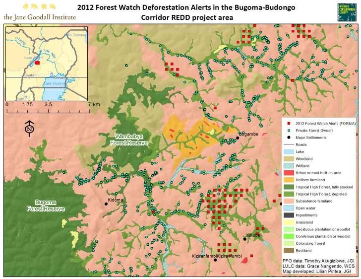
76

77

78

79


80

81
82

83

84 One of the dozens of Private Forest Owners Associations organized by JGI-Uganda and mapped using Google Android tablets, ODK and ArcGIS/Esri technologies
85

86

87
88 Key Successes & Lessons Learned Community generated data key Informed, objective and transparent communication New threats identified and addressed Community generated data useful for modeling chimpanzee distribution and monitoring threats Baseline data to monitor and measure success at the community and regional level Great potential to integrate community generated data in the cloud with other applications and efforts: Chimp distribution modeling Using and validating global mapping and monitoring data from satellite images Even if technology is straightforward there is a need for technical personnel in the field to address ongoing technology issues (e.g. system updates) Need for a local sustainable business solution to battery/power challenge Need to access internet by the communities directly Understanding local cultures, decision-making processes and policies key to technology adoption
, Eve CiziAndagamo, ICCN Researcher and Kahuzi Biega")

89 Testing ODK for Chimpanzee and Gorilla Surveys in Eastern DR Congo ChrysoKaghoma, Field Research Assistant (FFI), Eve CiziAndagamo, ICCN Researcher and Kahuzi Biega National Park rangers Chryso Kaghoma Field Research Assistant (FFI) testing the useof Google Nexus 7 tablet to collect gorilla dung data in Kahuzi Biega National Park (March 14, 2013)

90 THANK YOU! Local communities and Governments of Tanzania, DRC, Uganda and Republic of Congo