Design and Operations and Management of GIS Workflows for Multi-utilities. Benoit Fredericque Senior Product Line Manager Geospatial Desktop & Mobile
|
|
|
- Nelson Gray
- 5 years ago
- Views:
Transcription

1 Design and Operations and Management of GIS Workflows for Multi-utilities Benoit Fredericque Senior Product Line Manager Geospatial Desktop & Mobile

2 The Utilities Industry Is Changing Climate change and environmental concerns Growth in renewable generation and distributed resources Aging asset performance with increased expectations on reliability Increased pressure on operational efficiency and workforce productivity Increasing desire by consumers for a role in energy management and conservation New entrants and disruptive technologies 4


3 Business Challenges in Utilities Q: What are the three most pressing challenges for your Utility? Source: the State of the Electric Utility,


4 Utility Infrastructure Assets They are large, complex systems Not simply discrete equipment, schedules and resources Many involve one or more complex networks Transportation, Utilities Networks may need to be overlaid Service life spans of 50 to 100 years Updates and upgrades involve significant engineering and design Serve the public Both private and public enterprises Need to support public inquiry, reporting and response Concerned with level-ofservice and public safety Continuous operation 6

5 Advancing GIS for Utilities Infrastructure Going away with the divide between engineers and GIS specialists Geospatial technology made available seamlessly within information modelling applications Working with existing spatial data repositories Supporting standards published and de facto 8
6 Bentley Mission Statement for Utilities ( ) To capture the mindshare of the Utilities community with software that inspires the design, build and operation of world-class utilities. 9


7 Bentley s Solutions for Utilities Pipes a suite of design, simulation, and information management software for professionals to design, build, and operate utilities transmission and distribution networks. Gas Distribution District Energy Pipeline Wires and Cables Electric Distribution Electric Transmission Substation Water Communications Wastewater 10


8 Implementing the Vision Showcasing Bentley solutions in three disciplines: Desktop GIS for Utilities Point Cloud for Utilities Mobile GIS application for Utilities 11
9 GIS for Utilities
10 Bentley GIS for Utilities Integrate design and operation and maintenance in a single environment Evolves around workflow management for guided create and change processes Offer industry standard utility data models for quick product deployment Integrate accurate CAD-based layout and design with GIS analytical capabilities, and spatial database support 13

11 Job and Workflow Management Manages multiple workflows Support branching, tracking status and states, markup and approval Improves information access, collaboration, and security Reduces redundant data entry and manual errors 14

12 Industry Data Models to Manage Utility Assets Framework for organizing and maintaining electric, gas, water and wastewater utility data More than 150 Objects Including attributes, relationships, behavior Off-the-shelf solution Can be customized, enhanced, localized 15

13 Integrated CAD, GIS & Spatial Capabilities All of MicroStation and Bentley- Map built-in High-precision placement tools GIS analysis tools Query, Search & Locate Thematic mapping, buffering, overlay Map finishing and reporting Seamless Spatial data access Oracle and SQL Server Short and long transactions 16
14 Smart Layout Editing Managed edits of network layouts Connected/Related assets are changed according to predefined rules Update as-built data and proposed infrastructures Maintain the layout intent as you edit Dynamic display of (proposed) changess 17
15 18 Smart Layout Editing
16 Outage Planner Advanced tracing tool to: Prevent outages caused by operation and maintenance Aid to manage unplanned outages Identifies and associates assets and customers to system impact areas Seamless workflow management integration 19
17 20 Outage Planner


18 GIS for Utilities Challenges Gain control over data creation and editing process Analytical capabilities during the design process Editing capabilities during operation and maintenance Improving information mobility To better face these challenges Bentley announces OpenUtilities 21


19 What is OpenUtilities? Standalone Multi-utility GIS Electric, Gas, Water, Wastewater, District Energy Open SQL Server Spatial Oracle Spatial and more Offered for Three User Levels OpenUtilities PowerView OpenUtilities Map OpenUtilities Designer Includes WaterCAD and SewerCAD Modeling for Design 22

20 23 How will OpenUtilities be Introduced?
21 Point Cloud for Utilities


22 25 Aerial LIDAR to Transmission line models


23 What are Point Clouds? Point Cloud = a data type made of millions or billions of points. Data acquired from scanner mounted on different platforms: Aircraft, Mobile (boat, trucks, trolley..) & Static XYZ + Intensity, RGB if combined with Digital camera 26
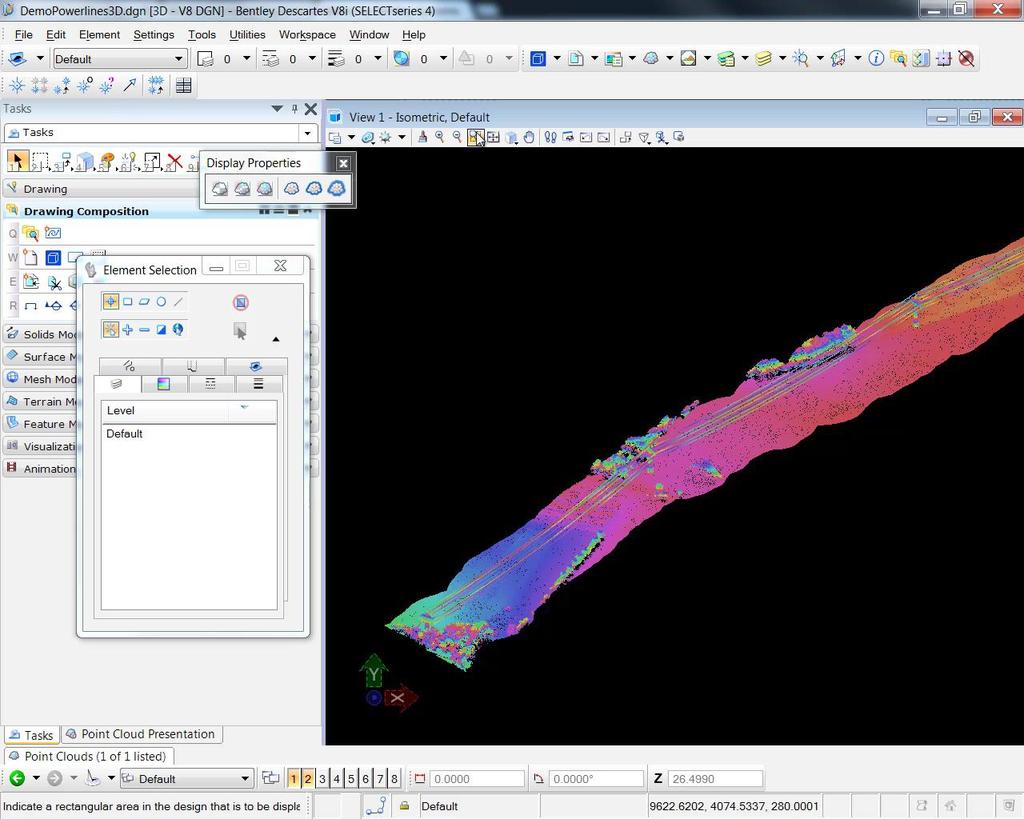
24 27


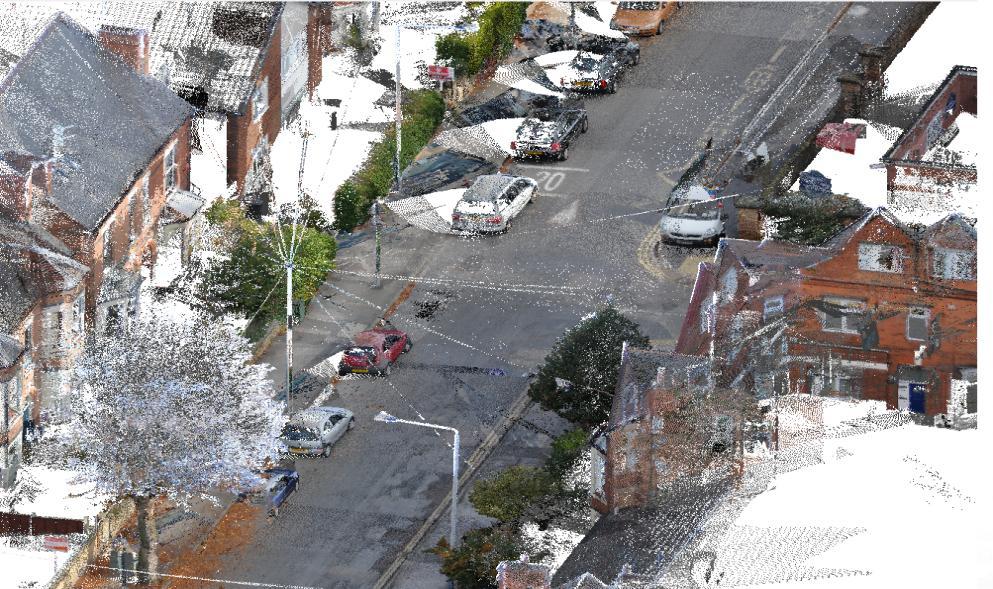
25 28 Mobile Mapping to Asset information

26 Asset management :on-demand 3D measurement 29 Data captured by StreetMapper

27 Survey 3D Assets from Point Clouds Great alternative for manually surveying sites Replaces traditional survey documents Reduces time on-site 30


28 Applying Point Clouds in Substation Engineering further enhancing the software-drive process to design, and build power substations and manage as-built models and documentation Explore new substation sites Perform comprehensive site development Build Intelligent 3D Substation Models from Point Cloud Scans Reuse and Repurpose Existing Substations Engineer Physical Layout Design Protection & Control Design substation structures and buildings Manage design and build Manage as-built information Share substation model with other systems 31 Analyze comprehensive substation model

29 Substation Point Cloud on Mobile Use of Point Clouds is not limited to the desktop alone Information mobility ensures Point Cloud data is also available on mobile devices 32
30 Information Mobility


31 Information Mobility versus Mortality Information Lifecycle Information Mortality 34

32 Information Mobility in the field Mobile devices have worked their way into more and more phases of business workflows. Tablets and smartphones now offer a combination of computing power, graphics performance, and communications bandwidth that makes them capable of handling computing tasks heretofore relegated to desktop or even server computers. However, it would be a mistake to view the opportunity afforded by mobile devices as portable desktop computers. Mobile devices don t replace desktop computers in fact, neither is particularly well suited for the other s role. Instead, their convenience factor (portability, GPS, cameras, radios, video, gyros, etc.) makes them uniquely suited to address one of the most costly and longest standing issue since the dawn of computer-aided-business: the disconnect between information systems and information consumers. That s where information is missing or wrong, mistakes are made, dollars and time are wasted, and opportunity is lost. We now have the hardware, all we need is software. 35


33 Accessing Utilities Information in the Field Field workers involved in inspections require up-todate information on all infrastructure assets Workers are often disconnected from the corporate network or in locations where network connectivity is limited 36


34 Mobility for Utilities Challenges Provide efficient data workflows for mobile applications Offer disconnected and connect access to data Open up two-way interaction with mobile applications Process redlining, forms input 37


35 Bentley Map Mobile offers Simple touch and gesture interface Fast access to geospatial data in the field Locate assets based on query or GPS location Disconnected mode for standalone operation Full query and review of geospatial data 38

36 Bentley Map Mobile Data Generation Desktop, interactive generation Save data as i-model Bentley Map Mobile Publisher Enterprise Data Generation Scheduling, load balancing Transformation tools i-model Composition Server 39


37 Coming this year! Measure Tools Search Improvements Highlight similar features New user Interface: File Browser Pop out tools Virtual Mouse 41
38 Mission Critical Geospatial Technology in Utilities The utilities industry is changing continuously, but infrastructure assets remain an important focal point Solutions for GIS for Utilities, Point Clouds and Information Mobility bring opportunities to Utilities to control infrastructure assets and adopt to change Bentley is committed to capture the mindshare of the Utilities community with software that inspires the design, build and operation of world-class utilities. 42