The Power of Spatially Enabling Your Real-time Facilities Data. Copyright 2015 OSIsoft, LLC
|
|
|
- Avis White
- 5 years ago
- Views:
Transcription

1 The Power of Spatially Enabling Your Real-time Facilities Data Presented by James Sullivan
2 Recommended Flow of Topics in Agenda Business Challenge About GIS ArcGIS Platform and the PI System Create and Use Maps For Demonstration of FM integration Conclusion Questions 2


3 3

4 GIS is a System of Record Organizing and managing the geographic context of your assets and resources 4

5 Increased Demand For authoritative mapping and location-aware apps at work Pew Research Center 74% of adults use their smartphone to get directions or other information based on their current location 5

6 Social Devices Apps 6


7 58% Own a Smartphone 2.8 Devices Owned by Knowledge Workers 87% Using the Internet 7
8 Desktop Web Device ArcGIS An Integrated Web GIS Platform Portal Providing mapping, analysis, data management, and collaboration Server Online Content and Services 8


9 GIS Integrates All Types of Geospatial Information Spreadsheets Maps Social Media Massive Content Analysis Services DBMS Imagery Sensor Networks Tradecraft 9


10 ArcGIS Utilizes Building Information Integrating Building Data with Other Geographic Information BIM 3-D Tools Interoperability Web Server Extract, Translate, Load CAD/BIM Standards Interchange Formats CAD Specifications BOMA/FICM OmniClass COBie OSCRE Tools 2D & 3D Data Models 4D Historic Playback Editing Visualization Design Analysis 10
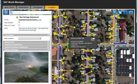
11 ArcGIS Integrates & Geo-enriches Enterprise Systems Providing Mapping and Location Analytics Business Systems Integration with leading Facility, Infrastructure, Safety & Security systems of record Database Web Service (REST) API 11

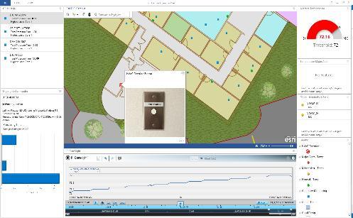
12 ArcGIS Geo-enriches PI PI Integrator Providing Robust Mapping and Location Analytics Capabilities Business Systems Delivering real-time analytics across space and time Together delivering better business decisions 12

13 ArcGIS Platform Solutions for FM 3 Primary Business Patterns Mapping & Location Analytics for common needs complimenting your existing real property and facilities management technologies 13

14 Maps at Work Integrate, display, analyze, and enrich information from many sources spreadsheets sensor networks Images video web services big data collections business systems analytics spatial data social media 14
15 Common Approach Rapidly deploy initial operating capability to everyone then develop custom apps and integrate with other systems Initial Operating Capability Foundation Apps Essential Information Products ArcGIS Online Portal Desktop Web Device Integrated Enterprise System Extended / Custom Apps Integration with Business Systems (e.g. OSIsoft PI) Advanced Workflows GIS Ready Data Server Online Content and Services Content Production Systems Data Modernization 15

16 Maps at Work Illustrate time, show status and performance, and support decision making 16


17 Maps for Portfolio Management Increasing cost efficiencies, occupant productivity & satisfaction, & revenue generation Site selection and demographic analysis Indoor space & amenity site selection Real-time portfolio performance mapping Building performance mapping Space allocation and utilization 17


18 Maps for Operations Increasing cost efficiencies, reducing response times, optimizing tasks Active, high priority work orders Optimized route scheduling & dispatch to work order location both outdoors & indoors Real-time indoor environment monitoring & alerts Density or hot spot analysis of work order activity Alerts for service requests & scheduled maintenance 18

19 ArcGIS & The PI System A Powerful Combination 19


20 Maps for Safety & Security Reducing and mitigating risks; improving occupant health; optimizing compliance Natural hazard & continuity of operations Risk assessment & planning Event planning, safety, and security Live camera feeds and viewsheds ADA compliance and emergency evacuation routes


21 ArcGIS Templates for Facilities Mapping & Analytics Building, Campus and Portfolio Levels of Details Mapping Replace Image 22

22 Demonstration: The PI System & ArcGIS Real-Time Analytics in Space and Time at the Esri DC Office 23
23 Esri-OSIsoft Solution Bundle A great way to get started with ArcGIS integration with the PI System using the PI Integrator Inquire with your OSIsoft acct executive 24
 A. Spatially enable your facilities data B. PI Integrator for Esri ArcGIS C.")
24 The Power of Spatially Enabling your Real-Time Facilities Data A map is a powerful context to enable better decisionmaking Business Challenges A. Consumerization of IT B. Real-time facilities data on an easy to use map C. Missing spatial trends in facilities data Solution(s) A. Spatially enable your facilities data B. PI Integrator for Esri ArcGIS C. Bring real-time data from many different systems together onto one map Results and Benefits Recognize/analyze spatial trends Faster response time Reduce costs/increase security posture 2 5

25 Esri serving our users, advancing GIS, and promoting spatial literacy
26 James Sullivan Solution Engineer Esri Inc. 27


27 Questions Please wait for the microphone before asking your questions State your name & company 2 8

28