ArcGIS Workflow Manager: Effectively Managing Workflows within the ArcGIS Enterprise
|
|
|
- Arline Pitts
- 5 years ago
- Views:
Transcription


1 ArcGIS Workflow Manager: Effectively Managing Workflows within the ArcGIS Enterprise Elizabeth Wilcox and Bryan Piersol Guest Presenter: Ronnie Buzzard, United States Army Geospatial Center
2 Our plan today Workshop Agenda ArcGIS Workflow Manager entry points to the ArcGIS Enterprise ArcGIS Workflow Manager Use Case: United States Army Geospatial Center implements ArcGIS Workflow Manager Additional Resources


3 Our Organizations People Processes Products
4 Are your workflows automated and documented today?

5 Without Standards
6 What is ArcGIS Workflow Manager? Configure & Create Execute & Manage Evaluate & Improve WORKFLOW MANAGER PROCESS A framework for operational efficiency
7 With Standards
8 Automation Faster Data Actualization Lower Costs Adhere to Standards Resources and Support


9 Demonstration Points of Entry - Workforce - Collector & Navigator ArcGIS Workflow Manager - Execute through ArcGIS Pro
10 Getting Started Entry Points, Usage, Portal Integration

11 Compatibility with Esri Apps Workforce Create Workforce Assignments from Workflow Manager Collector Create Feature Service for collection and distribute the URL using Workflow Manager Operations Dashboard See the Status of Jobs in your Organization Web AppBuilder Widget Coming soon Create Workflow Manager jobs Samples available on Github
12 Extensibility Developer Options Integrate with other systems - Extended Properties - Desktop APIs - Web APOs Dashboards for GIS Work
13 System Framework Enterprise Web Applications ArcGIS Pro Administrator Geospatial data Client Applications Workflow Geodatabase


14 What is a Job? Anatomy of a Job Descriptive Information Activity Log Resource Workflow Geographical Location of Interest
15 Workflow Assignment Simplify workforce management Prepare Automatically route work Target specific groups Document Technical Writer Varying staff skills Editing Manage large workforces Editing team Quality Control QA team Notify
16 Workflow Manager and Tasks Macro and micro workflows Workflow Tasks are tailored for repeatable steps inside ArcGIS Pro Workflows are Enterprise wide Editing Editing Task Workflow Manager steps can load tasks Quality Control Quality Control Task

 Point of Interest")
17 Location of Interest (LOI) The geographic extent of work + Area of Interest (AOI) Point of Interest (POI)


 - Web editing")
18 Portal Integration Sharing data across the organization Share data across the organization in real-time Edit web maps and feature services - Location of Interest (LOI) - Web editing Publish services to Portal


19 Demonstration Situational Awareness - Operations Dashboard Administration / Configuration - Creating and designing workflows

20 Use Case in Operations Ronnie Buzzard, United States Army Geospatial Center
21 Army Standardized Map Production using Workflow Manager Ronnie Buzzard Army Geospatial Center (AGC)
22 Army Geospatial Data Production Units Army Geospatial Center data production teams: - Urban Team Urban Tactical Planner - Water Resources Team Water Resources Data Base (WRDB) Geospatial Planning Cells: US Army Geospatial Planning Cells, are ASCC level units assigned to each command that manage the enterprise geospatial database compiled from all sources including National Geospatial Agency, Topographic Engineering Center and other services, coalition allies, as well as exploiting new collection and production from deployed Soldiers and sensors - TLM/TM maps
23 Purpose of Workflow Manager at Army Production Units The TDM system was developed and implemented as a pilot program to assist, and maximize data production elements: - Product Standard mapping data - Tools to facilitate standardizes mapping data production - Production of TLM/TM, UTP & Water Resources data & Maps - Elimination and/or reduction of time consuming redundant tasks - Ability to produce a more repeatable process - Configured workflows submitted back to ESRI defense mapping for inclusion in OTB workflows
24 Challenges with Workflow Manager Difficult to integrate with Army systems & AI Requirements Difficult to manage, modify and maintain Extensive training requirements to use, configure, manage & modify Additional sw & hw requirements to units Additional potential for problems in a more complex system & more troubleshooting requirements for trained personnel Extensive complex toolset that can confuse un-trained or beginning personnel. Expanded potential for error Stop / start / wait
25 TDM x Fix to issues Simplify! Simplify! Simplify! Work with Workflow Manager Server & interact via portal app Variables are submitted to workflow manager and processed on server No need to integrate with DCGS-A or Army systems as only need browser & Desktop All variables are submitted to Workflow Manager Server at once to eliminate start / stop / wait issues Only simple steps are possible with complex toolset eliminated. Eliminating training
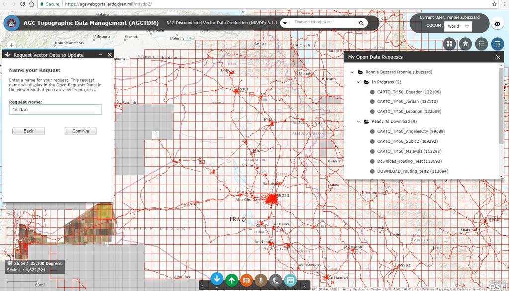
26 Workflow Manager Server integration with Portal Utilize Portal technology to federate, coordinate, and visualize production & data Manage & Visualize multiple production entities Enforce standards and implement Army wide QA/QC Common starting point (i.e. loaded data) Better utilization of other mapping tools (i.e. Esri Defense Production, Rapid map graphic, symbols) Quick updates & communication with users
27 Workflows on AGE (Army Geospatial Enterprise) Portal Data Production workflows (checkout replicas w/ check-in workflows): - Simple production - Urban production - Full TLM / TM mapping production Cartographic workflows: - TM 50 Analysis workflows: - Routing

28 Data download / production in a checkout replica

29

30

31

32
33

34

35 Cartographic workflow: TM 50

36 Map Package and/or.pdf


37 Limited Workflow Manager tools
38 Questions / Comments

39 Workflow Manager to automate and document your workflows!
40 Resources ArcGIS Workflow Manager product information Geonet - Product Page - Training - Samples
41 Print Your Certificate of Attendance Print stations located in the 140 Concourse Tuesday 12:30 pm 6:30 pm GIS Solutions Expo Hall B Wednesday 10:30 am 5:15 pm GIS Solutions Expo Hall B 5:00 pm 6:30 pm GIS Solutions Expo Social Hall B 6:30 pm 9:00 pm Networking Reception Smithsonian National Portrait Gallery


42 Download the Esri Events app and find your event Please Take Our Survey in the Esri Events App Select the session you attended Scroll down to find the feedback section Complete answers and select Submit


43