PACES: Preparedness for Appropriate accommodation in Emergency Shelters
|
|
|
- Aileen Ramsey
- 5 years ago
- Views:
Transcription

1 April 19 th 2016 Scenario Workshop PACES: Preparedness for Appropriate Accommodation in Emergency Shelters Nicholas Kyriakides Christis Chrysostomou Cyprus University of Technology, Cyprus Scenario Workshop, Project 19 April co-funded 2016, FORTH, by the Heraklion, EU Humanitarian Crete, Greece Aid and Civil Protection
2 Introduction Case study area Building stock Hazard Vulnerability Methodology Scenarios Conclusions Layout


3 Introduction The island of Cyprus, which is located in the North Eastern Mediterranean region, lies within the second highest seismic hazard zone of the earth. Throughout its history, Cyprus has suffered significant damage due to earthquakes. Since 1995, three major earthquakes, with magnitudes Ms > 5.7 have hit the island, causing three fatalities, approximately 50 injuries, severe structural damage and economic losses, which add up to approximately 15 million. This has increased concern amongst the people of Cyprus and highlighted the need for improved risk assessment and management. The first basic seismic provisions in the island were introduced in 1986 followed by a formal and comprehensive seismic code in 1994.
4 Introduction Cyprus lies on the southern part of a diffuse boundary between the African and the Eurasian tectonic plates The African plate, which is moving towards the north pressurizes the Eurasian plate. The Cyprian Arc is the point of contact of the African plate with the Eurasian plate, which is regarded as either a plate boundary or a broad zone of thrusting and is believed to responsible for most of the earthquakes occurring in the island

5 Introduction
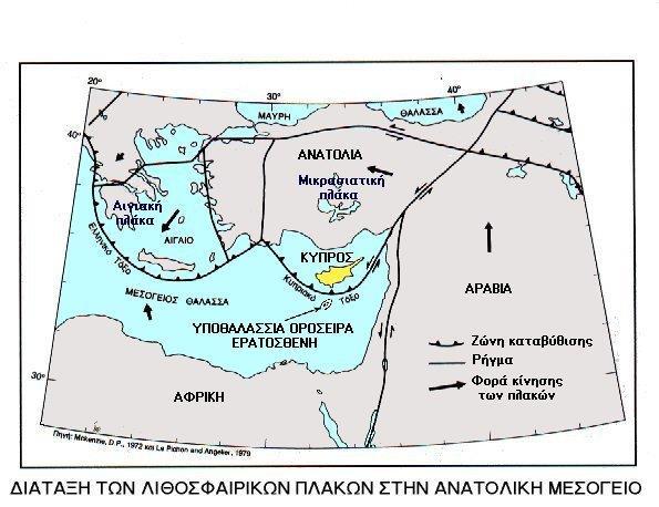
6 Introduction Cyprean Arc

7 Seismic activity in the area Introduction Concentration in the south-west offshore area in the Cyprean arc zone and lately increased activity near Yerasa

8 Introduction The quantification of the unwanted consequences from earthquakes can be achieved through risk assessment, which defines, monetarily, the amount of prospective damage inflicted on structures and the population by an earthquake. Seismic risk assessment is used as a tool for the prevention, preparedness and mitigation of the consequences from seismic events and is based on the assumption that losses depend on the quality of the building stock (zero seismic risk in deserts).
9 Case Study area In order to examine the seismic risk of the existing building stock of the island it was decided to use the municipality of Limassol as a case study as it is situated at the southern part, which has proven to be of higher risk due to its proximity to the Cyprian Arc most of the buildings were constructed prior to the enforcement of the aseismic code, which is the case for all the tall buildings (>6 floors), with the use of low strength concrete and very low ductility reinforcement. Densely populated

10 Case Study Area The boundary of the district of Limassol is shown with the red line (left figure), whereas the borders of the Limassol municipality, which is the case study area, are shown with the black line. The spatial distribution of buildings in the municipality is shown in the right figure. It is observed that it comprises of a very dense building stock concentrated close to the coastal line.
11 Compilation of building stock The Building database was provided by the Department of Land and Surveys in GIS format (building level). The database was updated up to The Population database in GIS format per municipality and community was obtained from the 2011 Census of Population which was conducted by the Cyprus Statistical Service Based on the estimated data from the municipality it was observed that nearly 70% of the existing building stock lacks any seismic design (i.e. constructed prior to 1994) Of those, approximately 600 buildings are 3-5 floors and floors
12 Building classification- Risk UE building taxonomy 1. RC1L: Nearly 70% of the existing building stock (65% are one floor). 60% of them were build with no seismic provisions (DCL). 2. RC1M: Nearly 70% are 5 storeys (approximately 600 buildings are 3-5 floors). Very few are on average 7 floors ( 200) 3. Construction period was determined based on assumption for the % of buildings before and after seismic codes (1991). Such statistics were established from local studies. 4. Building height was provided by the database 5. M2 (adobe) and M6 (massive stone) are approximately 4000 in the municipality


13 Compilation of building stock Buildings were allocated into grid cells to be compatible with ELER (κάναβος 1km 2 )


14 Databases
 through region specific ground motion prediction equations and using shear wave velocity distributions or other site descriptors.")
15 Risk Assessment methodology For a given earthquake magnitude and epicenter information, estimation of the spatial distribution of selected ground motion attenuation equations with selected parameters (MMI or PGA) through region specific ground motion prediction equations and using shear wave velocity distributions or other site descriptors. Estimation of the building damage (fragility curves) and human casualty at different levels of sophistication that commensurate with the availability of inventory of human built environment Estimation of direct economic losses stemming from building damages using damage indices per damage level (grades)
 as part of the funded research regional program EMME (Earthquake Model for the")

16 Risk Assessment methodology For the application of the methodology, a software was developed (ELER-Earthquake Loss Estimation Routine) as part of the funded research regional program EMME (Earthquake Model for the Middle East) for the the rapid estimation of earthquake shaking and losses in the Euro-Mediterranean region. The methodology that is used in this software is capable of developing scenario earthquake based loss assessments.
17 Risk Assessment methodology
18 Seismic Vulnerability Vulnerability curves for Level 1 assessment were derived based on EMS-98 (do not account for specific structural characteristic of RC buildings in Cyprus but rather general typical ones) and are used for a preliminary assessment of the risk in monetary terms at city or country level Hazard is expressed in the form of MMI attenuation laws % of the Building Stock Intensity Based Vulnerability Curves-Cyprus-RC1-DCL-L D5 D4 D3 D2 D EMS98 Intensity EMS98 Intensity RC_No seismic_low rise RC_Modern Seismic_low rise % of the Building Stock Intensity Based Vulnerability Curves-Cyprus-RC1-DCM-M D5 D4 D3 D2 D1
19 Seismic Vulnerability-EMS98
20 Seismic Vulnerability-Fragility curves Fragility curves describe the relationship between the probability of being or exceeding a particular (structurally defined and representative of the building stock) damage state and the seismic hazard (PGA) and are used for detailed risk assessment (capacity demand diagram methods)-level 2

21 Seismic Hazard For Level 2 assessment hazard is expressed in the form of local response spectra The derived spectra for the 2 zones defined in the Microzonation study were substituted into the software and can be used for detailed assessment at city level

22 Risk Assessment Scenarios Level 1 assessment for country level 2 seismic hazard scenarios were used (design with 475 year return period and maximum credible earthquake with 2475 y.) MMI were calculated for each scenario using local seismotectonic and geological conditions (MMI=8 and 10)
23 Risk Assessment Scenarios The predictions regarding the seismic hazard for the RP=475yrs earthquake show good correlation with the design hazard map for Cyprus included in the National Annex of Eurocode 8. The existing design hazard map proposes a PGA=0.25g for this area. As expected lower intensities are predicted for the remaining part of the island (mainland) which is at a greater distance from the fault.
 20% with DG3 As a 1 st estimate 5.")
24 Scenario 1 For the design earthquake the distribution of damage is shown below 12% of buildings with DG4+DG5 ( buildings) 20% with DG3 As a 1 st estimate inhabitants are expected to be relocated

25 Scenario 2 For the maximum credible earthquake the distribution of damage is shown below 30% of buildings with DG4+DG5 25% with DG3 As a 1 st estimate inhabitants are expected to be relocated
26 Risk Assessment methodology Level 2 assessment focused on Limassol municipality using very detailed building inventory for the area. It was concluded that for the 475 yrs scenario included in the design hazard map for Cyprus (PGA=0.25g along the coast) approximately 6000 buildings will suffer extreme damage in the city of Limassol. The results verified closely the level 1 assessment


27 Simulation PACES: Preparedness for Appropriate accommodation in Emergency Shelters Simulation of 1995 Paphos earthquake
28 Thank you for your attention