DEVELOPMENT STANDARDS FOR RESIDENTIAL ZONES
|
|
|
- Gordon Tyler
- 5 years ago
- Views:
Transcription
1 DEVELOPMENT STANDARDS FOR RESIDENTIAL ZONES The following provides a summary of the language and methodology changes that have been approved by the SunPAC for the commercial zone and applied to residential zone: o SunPAC voted to change the FAR calculation methodology to interior of exterior wall, consistent with the rest of the County. Including definitions for FAR and basement. Note: the basement definition is pending further discussion on 7/16/08. o SunPAC voted in favor of adopting the County s height calculation methodology. o Allowance for modifications as per the LUDC. The following excerpts are from the Land Use Development Code and provided for your information and consideration when reviewing the existing design guidelines. The code section and language has been provided below. In addition, if similar LUDC language is available, then it has been included for reference. Definitions (35.11; Glossary) Basement - Summerland. Any usable or unused under floor space where the finished floor directly above is not more than four feet above grade (as defined by the latest addition of the Uniform Building Code). Note: pending further discussion on 7/16/08. County Wide Basement. A story partly or wholly underground. A basement shall be counted as a story if its floor-to-ceiling height is 6.5 feet or more, and more than one-half of its height is above the average level of the adjoining ground surface. Floor Area, Net - Summerland. The total floor area of all floors of a building included within the exterior surfaces of the surrounding exterior walls, excluding unenclosed porches, balconies and decks. Interior stairs shall be counted on only one floor. County Wide Floor Area, Net. The gross floor area excluding shafts, stairways, corridors and halls, unusable attics, and unenclosed porches and balconies. Floor Area Ratio - Summerland. The net floor area of the structure divided by the net lot area. Montecito Coastal Floor Area Ratio - Montecito Coastal. A measurement of development intensity represented by the quotient of net floor area, excluding basements used exclusively for storage and residential units that meet the County s definition of affordable housing, divided by net lot area. Where there is an approved Final Development Plan, the floor are ratio shall be the quotient of net floor area, excluding basements used exclusively for storage and residential units that meet the County s definition of affordable hosing, divided by the sum of the net lot are of all lots included in the Development Plan.
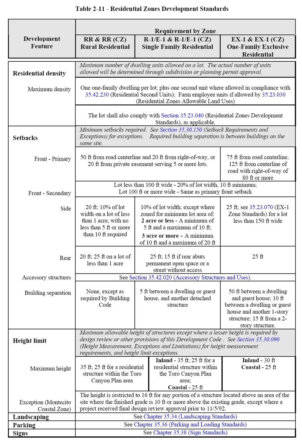
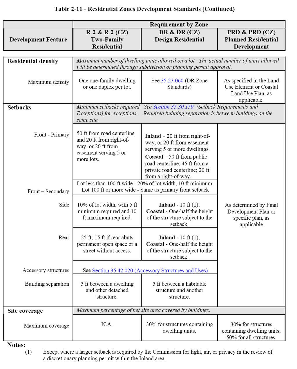
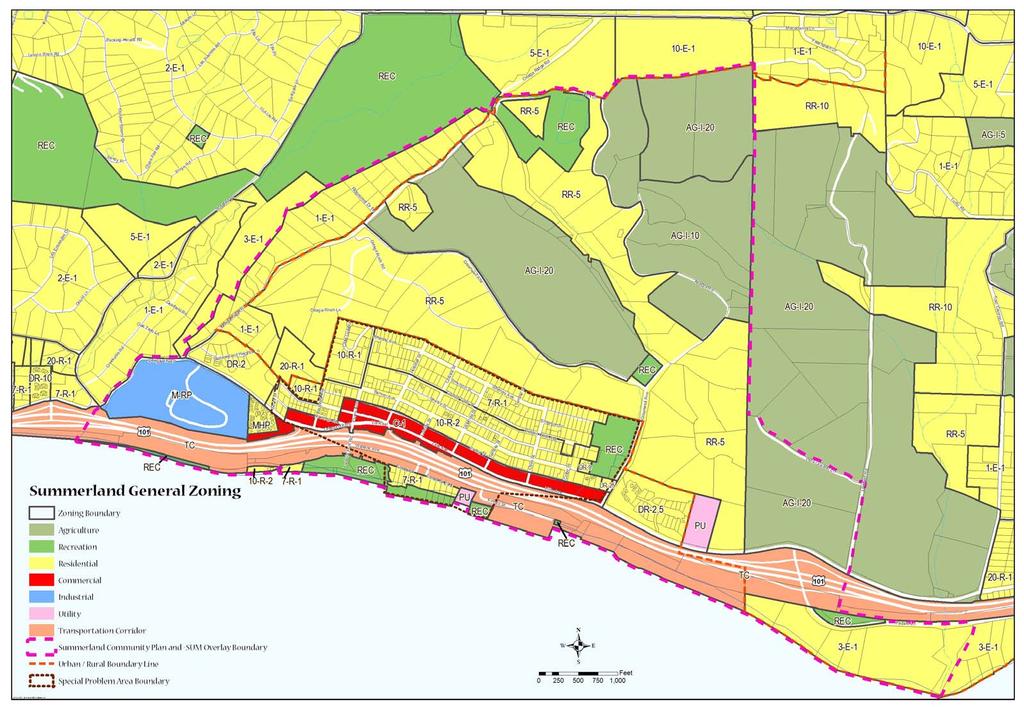
2 Lot Area, Net - Summerland. The gross lot area minus any area lying within a public street, such street being defined as a permanently reserved right-of-way which has been dedicated to the County of Santa Barbara. For the purpose of calculating the Floor Area Ratio, the net lot area shall also be reduced by any area that may not be utilized for structural development due to easements or encroachments that may include roads, well sites, utility installations, and portion of the property that in effect are used by other properties. County Wide Lot Area, Net. The gross lot area excluding any area lying within a public street, public street being defined as a permanently reserved right-of-way which has been dedicated to the County. Plate Heights - Summerland. The distance between the finished floor and where the wall intersects with the lower portion of the floor joists of the story above, or if there is no intervening story, the lower portion of the structural roof members. Understory - Summerland. The portion of the structure between the exposed finished floor and the finished grade. Residential Zones Development Standards ( ) Summerland's residential areas are located on the steep, ocean facing hillside above the commercial strip and on small hills and canyons to the north of the town. In town there is a mix of high density, multifamily apartments, duplexes, small cottages, and large new single family homes. Additionally, a small trailer park is located just west of the downtown. Surrounding the town area are single family homes on larger (15 acre) and agricultural uses (primarily orchards). Residential zones existing in the Summerland Community Plan area include the following (refer to the attached map for locations): R-1: Single Family Residential R-2: Two Family Residential RR: Rural Residential DR: Design Residential E-1: Single Family Estate Residential MHP: Mobile Home Planned Development AG: Agricultural Use A. General development standards. Development within the residential zones shall be designed, constructed, and established in compliance with the requirements in Table 2-11 and all applicable standards in Article 35.3 through Article 35.7 of this Development Code. These standards apply within the Coastal Zone and Inland area, except where noted. B. Community Plan overlay requirements. Section (Community Plan Overlays) establishes additional requirements and standards that apply to development and uses located in an applicable community or area plan as specified in Section (Community Plan Overlays).
3
4


5 Residential Zones Lot Standards ( ) C. Minimum building site area for residential use - Summerland. Within the Summerland Community Plan area, a minimum net lot area of 10,000 square feet is required for the development of a two-family dwelling in a 10-R-2 zone, instead of the minimum building site area required by Subsection B. (Minimum building site area for residential use) above.
 zone.")
6 Agricultural Zone Development Standards ( ) A. Design Residential (DR) zone. A landscape Landscaping Standards ( )
7 A. Design Residential (DR) zone. A landscape plan shall be approved for all development requiring a Development Plan within the DR zone. The landscape plan shall include, at a minimum, the following: 1. Uncovered parking areas shall be screened from the street and adjacent residences by hedges, dense plantings, solid fences or walls not less than four feet in height. 2. A landscape area with a minimum width of five feet shall be provided between all lot lines and any driveway or uncovered parking area except for areas provided for site access. 3. In the Inland area, a landscape area with a minimum width of 10 feet shall be provided adjacent to the perimeter lot lines of a clustered residential development. 4. Parking areas shall be landscaped in compliance with Section (Landscaping Requirements for Parking Areas) below. B. Mobile Home Planned Developments (MHP) zone and Mobile Home Subdivision (MHS) zone. A landscape plan shall be approved for all development requiring a Development Plan within the MHP and MHS zones. The landscape plan shall include, at a minimum the following: 1. Coastal Zone. Within the Coastal Zone landscaping shall be provided in compliance with the following: a. A minimum of one tree shall be planted on each mobile home site. b. The project site shall be enclosed with decorative wall or fence or landscaping not less than five feet in height except for areas provided for site access. c. A landscape buffer with a minimum width of 25 feet shall be provided adjacent to any lot line that abuts a residential zone. d. Parking areas shall be landscaped in compliance with Section (Landscaping Requirements for Parking Areas). Parking Standards ( ) A. Location. Required residential parking spaces shall be provided on the same site that the dwelling is located, except as provided in Subsection J. [Medium and High Density Student Residential (SR-M) and (SR-H) zones] below. For dwelling units containing two or more bedrooms in multiple-family residential developments, spaces shall be located within 200 feet of the dwelling that the space serves. B. Overnight parking of commercial vehicles. For one-family and two-family dwelling units, not more than one bus or non-passenger motor vehicle or trailer used in commerce may be parked overnight on a lot. The bus, motor vehicle, or trailer shall not exceed two axles, four tons, or eight feet in height. This restriction shall not apply to the emergency overnight parking of disabled motor vehicles or trailers and the occasional overnight parking of moving vans, pickup, or delivery or construction vehicles or trailers when occasional overnight parking is reasonably serving the residential use of a particular lot.
8 C. Montecito Coastal Zone, construction and design. Tandem parking may be allowed on residentially zoned lots of 7,000 square feet or less within the Montecito Coastal Zone. D. Single Family Residential, (R-1) and Two-Family Residential (R-2), zones. 1. Agricultural product sales. A minimum of two parking spaces shall be provided. Parking spaces shall be located no closer than 20 feet to the right of way of any street. E. One-Family Exclusive Residential (EX-1) zone. Required parking shall be provided with adequate provisions for ingress from and egress to the street at the time the main structure is constructed or enlarged or at the time a guesthouse is erected. F. Design Residential (DR) zone. 1. Construction and design. Parking areas shall be arranged to prevent through traffic to other parking areas. 2. Encroachment prohibited Inland. Within the Inland Area only, laundry facilities located in a garage for a dwelling unit shall not encroach upon parking. 3. Landscape/screening of parking areas. Uncovered parking areas shall be screened in compliance with Subsection A [Design Residential (DR) zone] above, and Section (Landscaping Requirements for Parking Areas). 4. Location. Parking lots, carports, and garages designed and used for individual units within a development may be either adjacent to the units or centrally located to serve a group of units. 5. Setbacks. Uncovered parking areas shall be located no closer than 15 feet to the street right-of-way line or closer than five feet to a property line. 6. Agricultural product sales. A minimum of two parking spaces shall be provided. Parking spaces shall be located no closer than 20 feet to the right of way of any street. 7. Common parking areas. Preservation and maintenance of common parking areas shall be in compliance with Section (DR Zone Standards). G. Mobile Home Planned Development (MHP) zone, Inland area. 1. Storage areas for recreational vehicles shall be screened by landscaping and fencing for security purposes. Minimum dimensions for each storage space shall be 10 feet by 20 feet. 2. Common parking areas may be provided but shall not be located closer than 10 feet to a mobile home site. 3. A minimum of one parking space shall be located on each individual site. One additional space may be located in a common parking area located within the mobile home development. Tandem parking is allowed if two spaces are provided within an individual site.
9 4. Preservation and maintenance of common parking areas shall be in compliance with Subsection B.2 (Title to open space area). 5. Common parking areas shall be landscaped in compliance with Subsection C (Development Standards) Board of Architectural Review ( ) The following are the BAR findings for projects within the County, Coastal Area and Summerland Community Plan Area. 1. Findings required for all Design Review applications. A Design Review application shall be approved or conditionally approved only if the Board of Architectural Review first makes all of the following findings: a. Overall structure shapes, as well as parts of any structure (buildings, fences, screens, signs, towers, or walls) are in proportion to and in scale with other existing or permitted structures on the same site and in the area surrounding the subject property. b. Electrical and mechanical equipment will be well integrated into the total design concept. c. There will be harmony of color, composition, and material on all sides of a structure. d. There are a limited number of materials will be on the exterior face of the structure. e. There will be a harmonious relationship with existing and proposed adjoining developments, avoiding excessive variety and monotonous repetition, but allowing similarity of style, if warranted. f. Site layout, orientation, and location of structures and signs will be in an appropriate and well designed relationship to one another, and to the environmental qualities, open spaces, and topography of the site. g. Adequate landscaping will be provided in proportion to the project and the site with due regard to preservation of specimen and landmark trees, existing vegetation, selection of plantings that are appropriate to the project, and that adequate provisions have been made for maintenance of all landscaping. h. Signs, including associated lighting, are well designed and will be appropriate in size and location. i. The proposed development is consistent with any additional design standards as expressly adopted by the Board for a specific local area, community, or zone in compliance with Subsection G. (Local design standards) below. 2. Additional findings required for Design Review applications within the Coastal Zone. a. In areas designated as rural on the Comprehensive Plan maps, the design, height, and scale of structures is be compatible with the character of the surrounding natural environment, except where technical requirements dictate otherwise. Structures are subordinate in appearance to natural landforms; are designed to follow the natural contours of the landscape; and are sited so as not to intrude into the skyline as seen from public viewing places.
10 b In areas designated as urban on the Comprehensive Plan maps and in designated rural neighborhoods, new structures are compatible with the character and scale of the existing community. Clustered development, varied circulation patterns, and diverse housing types shall be encouraged. 4. Additional finding required for Design Review applications within the Summerland Community Plan Area. a. Plans for new or altered structures will be in compliance with the Summerland Board of Architectural Review Guidelines.
 is determined by the vertical")
11 COUNTY OF SANTA BARBARA Planning and Development Height Calculation Methodology Methodology applies to: Structures located inside the Summerland Planning Area. Except for structures located within the Coastal Zone on property zoned with the VC View Corridor Overlay, the height of a structure (not including fences and walls) is determined by the vertical distance between the existing grade and the uppermost point of the structure directly above that grade. If the structure is located within the Coastal Zone on property zoned with the VC View Corridor Overlay, then the height of the structure (not including fences and walls) is determined by the vertical distance between the average finished grade and uppermost point of the structure directly above that grade. The height of the structure shall not exceed the applicable height limit (see Diagram 1 below) except for certain limited exceptions discussed below. In addition to the height limit applicable to a structure as described above, a structure subject to the Ridgeline and Hillside Development Guidelines shall not exceed a maximum height of 32 feet as measured from the highest part of the structure, excluding chimneys, vents and noncommercial antennas, to the lowest point of the structure where an exterior wall intersects the finished grade or the existing grade, whichever is lower (see Diagram 2 below). 1. In the case where the lowest point of the structure is cantilevered over the ground surface, then the calculated maximum height shall include the vertical distance below the lowest point of the structure to the finished grade or the existing grade, whichever is lower. 2. This 32 foot limit may be increased by no more than three feet where the highest part of the structure is part of a roof element that exhibits a pitch of four in 12 (rise to run) or greater. EXCEPTIONS 1. Chimneys, church spires, elevator, mechanical and stair housings, flag poles, noncommercial antennas, towers, vents, and similar structures which are not used for human activity may be up to 50 feet in height in all zones subject to compliance with the F Airport Approach Overlay and the VC View Corridor Overlay. The use of
12 towers or similar structures to provide higher ceiling heights for habitable space shall be deemed a use intended for human activity. 2. Portions of a structure may exceed the applicable height limit by no more than three feet where the roof exhibits a pitch of four in 12 (rise to run) or greater. 3. Architectural elements (portions of a building that exceeds the height limit and extends beyond the roof of the building) with an aggregate area less than or equal to 10 percent of the roof area or 400 square feet, whichever is less, may exceed the height limit by no more than eight feet when approved by the BAR. 4. Special exemptions for oil/gas equipment (see Article II, Section a). DEFINITIONS Existing Grade: The existing condition of the ground elevation of the surface of a building site at the time of permit application, including Board of Architectural Review applications, that represents either (1) the natural grade prior to the placement of any fill on the site or the excavation or removal of earth from the site, or (2) the manufactured grade following the completion of an approved grading operation including grading approved in conjunction with the subdivision of the site. Finished Grade: The height of the manufactured grade of that portion of the lot covered by the structure following the completion of an approved grading operation. Finished Grade, Average: The average height of the manufactured grade of that portion of the lot covered by the structure following the completion of an approved grading operation. Height Limit: The maximum allowed height of a structure as established by an imaginary surface located at the allowed number of feet above and parallel to the existing grade. Diagram 1
13 Diagram 2
14