PRELIMINARY SHORELINE PROTECTION STUDY Parking Lot D to the JFK Library
|
|
|
- Juniper Chad O’Connor’
- 5 years ago
- Views:
Transcription
1 PREPARED FOR: UNIVERSITY OF MASSACHUSETTS BOSTON PRELIMINARY SHORELINE PROTECTION STUDY Parking Lot D to the JFK Library UNIVERSITY OF MASSACHUSETTS Boston, Massachusetts PREPARED BY: PARE CORPORATION 10 LINCOLN ROAD, SUITE 103 FOXBORO, MASSACHUSETTS PARE PROJECT NUMBER MAY 2008
2
3 UMASS Boston Preliminary Shoreline Protection Study PRELIMINARY SHORELINE PROTECTION STUDY Parking Lot D to the JFK Library UMASS BOSTON Boston, Massachusetts Table of Contents A. INTRODUCTION AND GENERAL INFORMATION... 1 B. EXISTING CONDITIONS AND SITE INFORMATION General Wave Climate Geotechnical Existing Permits... 3 C. IMPROVEMENT ALTERNATIVES Place Additional Riprap Revetment Protection; Keep Current Walkway Path Place Steel Sheeting Wall; Keep Current Walkway Path Construct New Revetment and Walkway (Similar to Adjacent Structures) Construct New Steel Sheet Pile Wall and Walkway... 4 D. EVALUATIONS AND RECOMMENDATIONS... 4 E. SUMMARY OF ANTICIPATED REGULATORY PERMIT FILINGS... 4 F NEXT STEPS 5 FIGURES FIGURE 1 AERIAL SITE PLAN FIGURE 2 EXISTING SITE PLAN SURVEY FIGURE 3 ALT 1 AND ALT 2 SITE PLAN AND SECTIONS FIGURE 4 ALT 3A AND ALT 3B SITE PLAN AND SECTIONS FIGURE 5 ALT 4A AND 4B SITE PLAN AND SECTIONS APPENDICES A. PHOTOGRAPHS B. FIRMETTE C. GEOTECHNICAL D. EXISTING PERMITS E. OPIONION OF PROBABLE COST Pare Corporation i
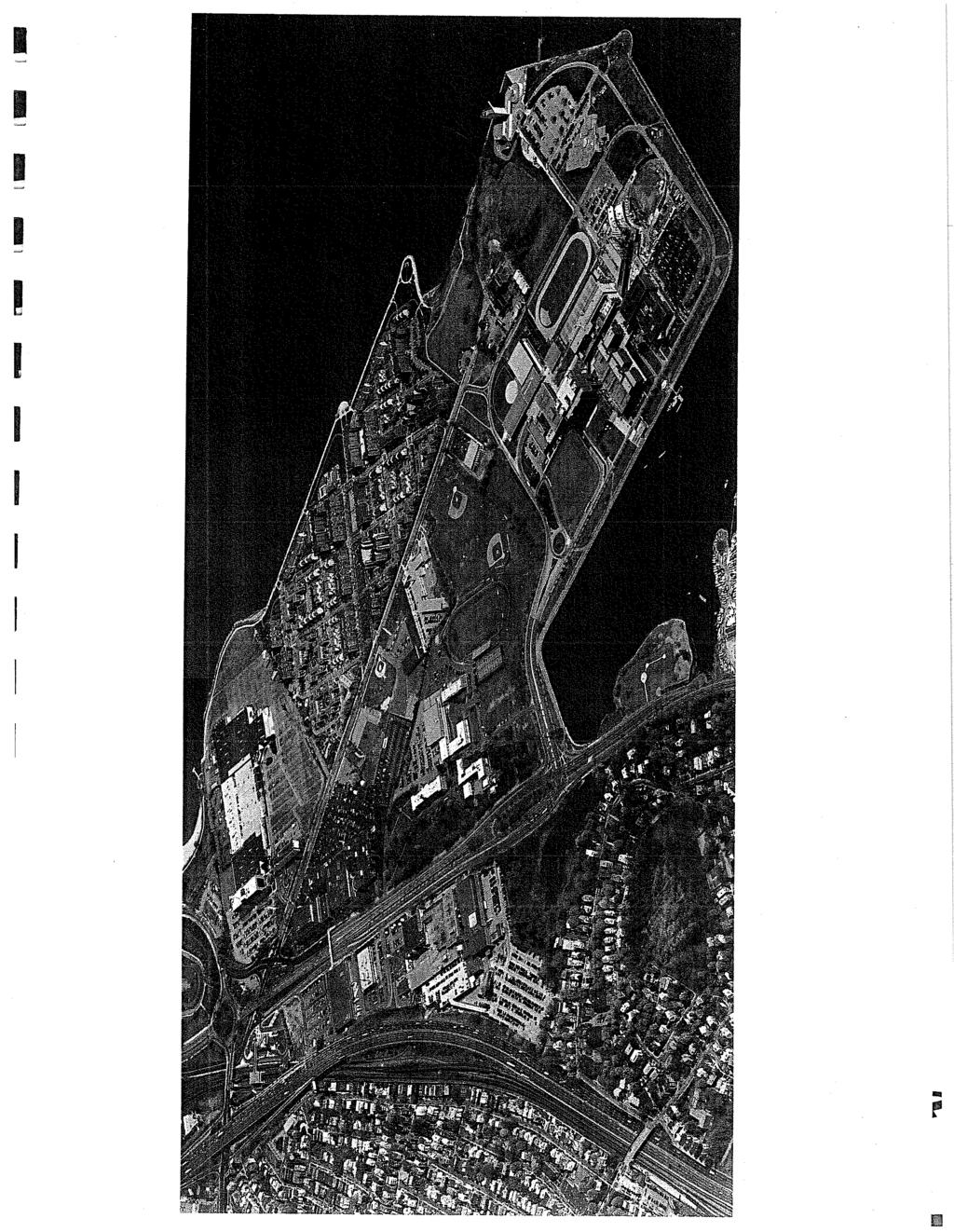
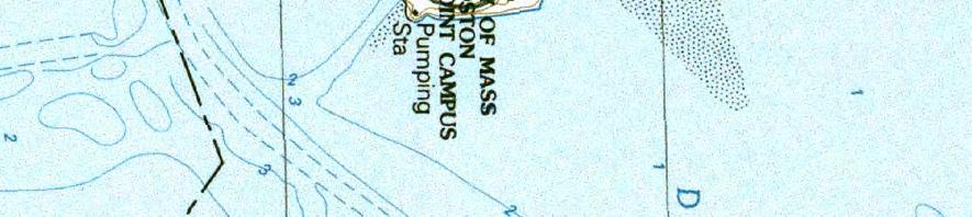
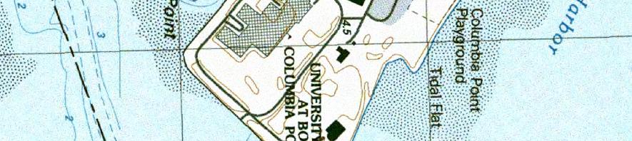
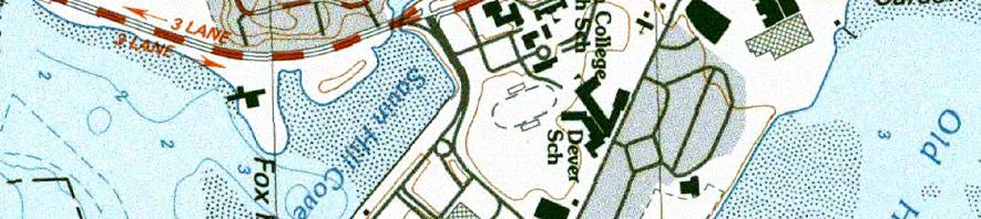
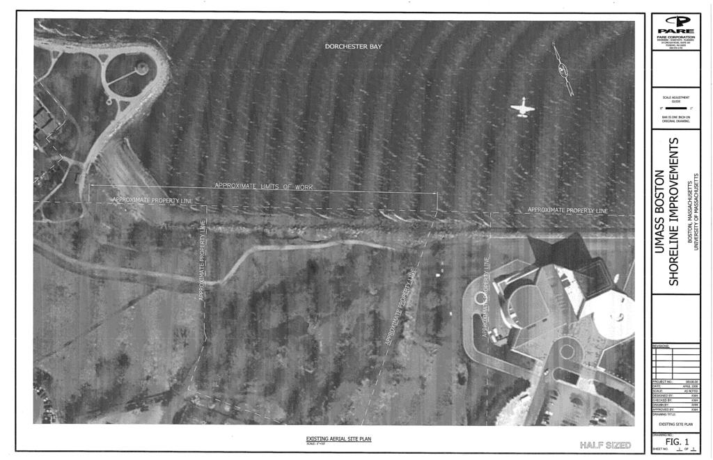
4 UMASS Boston Preliminary Shoreline Protection Study PRELIMINARY SHORELINE PROTECTION STUDY Parking Lot D to the JFK Library UMASS BOSTON Boston, Massachusetts A. INTRODUCTION AND GENERAL INFORMATION Pare Corporation (PARE) was retained by UMASS Boston carry out a preliminary feasibility study for the shoreline protection from the area on the north face of Columbia Point, between the JFK Library and Parking Lot D. The site is located as indicated on Figure 1 Aerial Site Plan, and also on Figure 2 Existing Site Plan Survey. This report presents the findings from our investigations and analyses. PARE engineers performed a visual inspection of the shoreline on April 16, Inspection of the shoreline was provided from the topside, the existing slope and also from the low water level. Photographs documenting the observed conditions are presented in Appendix B Photographs. The Columbia Point (formerly Harbor Point) site is comprised of filled lands over an existing tidal flat. Much of the UMASS infrastructure is constructed over a sanitary landfill. The Boston Improved Sewer pump station constructed in 1883 is located on the site. Shoreline protection at the adjacent JFK Library is comprised of a riprap stone revetment provided with a concrete paved harborwalk and protective railing. Similarly, the Columbia Point Development to the west is provided with a concrete harborwalk, with the shoreline protected by a similar riprap stone revetment. Photographs in Appendix A provide general features and conditions observed. B. EXISTING CONDITIONS AND SITE INFORMATION 1. GENERAL The existing section of shoreline being considered is comprised of a grassed or wooded backland area, with a stone dust path as indicated on the Site Plans. Figure 2 Existing Site Plan Survey provides topographic and property line information obtained from UMASS; additional shoreline slope information and elevations were obtained from survey performed by PARE on April 16, The stone dust walkway connects the adjacent concrete harborwalk structures of the JFK Library and the Columbia Point Development as described above. While the stone dust walkway serves the purpose of continuing the Harborwalk, it is the only area on Columbia Point that is not finished, and is somewhat of a weak link. In addition, the slope on the western end of the property is not handicap accessible as it exceeds the maximum permissible slope of 1 on 20. The existing shoreline was observed to be partially protected by remnants of a dumped rubble revetment, non-uniform in appearance, providing limited protection of the slope. At present, significant erosion of the backland area is occurring along the unprotected slope due to wave and tidal action. Photos in Appendix A document typical conditions observed. Pare Corporation 1
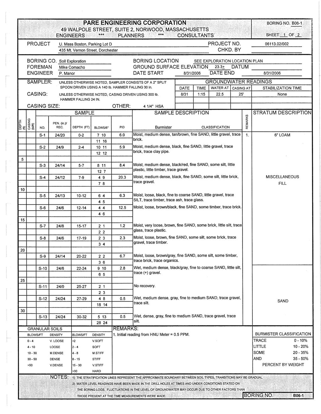
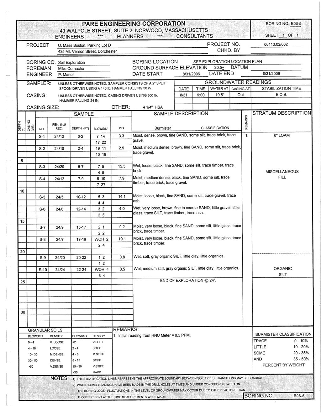
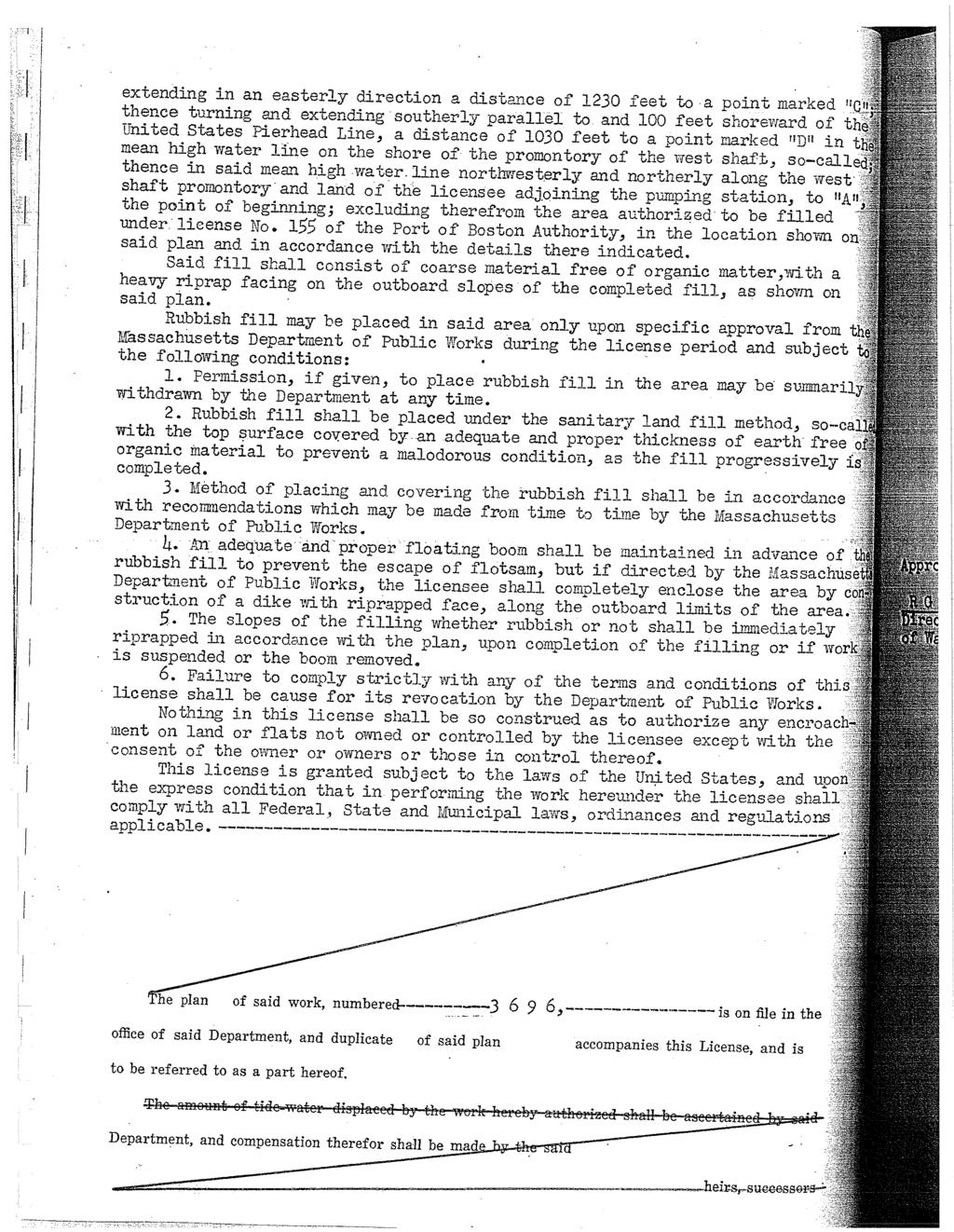
5 UMASS Boston Preliminary Shoreline Protection Study Several areas of the embankment were observed where the existing stone dust path is located immediately adjacent to the eroded vertical edge of the embankment. These areas are potentially unsafe, and if not addressed, will be subject to further erosion and imminent failure of the embankment during future severe storm or tidal events. Information regarding the rate of erosion at this site was reviewed. Coastal Zone Management Transects for the Columbia Point area indicate historical filling of the site, without any specific rates of erosion published. However, published information for typical Massachusetts shorelines indicate annual rates of erosion in the order of 0.5 feet per year (ref. J.O Connell, Woods Hole Oceanographic Institution, 2000). It is expected that the erosion and loss of embankment has been occurring over the last 17 years or so, likely beginning with the No Name storm in Other extreme events during this time period include the April Fools Day Storm of 1997, and the recent Mothers Day Storm in 2006 and the Patriots Day Storm in WAVE CLIMATE In accordance with the published FEMA Flood Insurance Rate Map, the majority of the shoreline is located in a V2 Zone, with a 100 year flood elevation of 16 feet above NGVD, or feet above Boston City Base (BCB). For reference, Boston City Base is 1.29 feet below mean low water. Calculations indicate that the 100 year recurrence interval significant wave height is in the order of 10 feet. The beach area adjacent to Parking Lot D and the Fathers Rest at Columbia Point Development is located in an A2 Zone, with an associated flood elevation of 11 feet above NGVD. The FIRMETTE for the area is presented in Appendix C. 3. GEOTECHNICAL A review of available geotechnical information indicates that the site is primarily comprised of urban landfill over a tidal flat. It is reported that incinerator ash is the main component of the area being considered. Copies of borehole data for the adjacent Parking Lot D are presented in Appendix D. 4. EXISTING PERMITS The Massachusetts DEP was contacted and visited to obtain copies of existing Chapter 91 Permits for the property and also the adjacent properties. Copies of available permits are attached in Appendix D. Review of the existing permits indicate that filling or modification of this area to protect the shoreline would be a permissible activity from a regulatory standpoint. C. IMPROVEMENT ALTERNATIVES The following options for shoreline protection have been proposed based on our past experience with structures of this type. The first and second alternates are comprised of minimum scope effort which will protect the existing stone dust walkway and edge of embankment. The existing edge of embankment will be protected by either stone revetment or steel sheet piling, respectively. No shoreside improvement has been carried other than the reinstatement of disturbed areas. Concrete walls have not been considered due to the assumed low load bearing capacity of existing site soils. The third and fourth alternates consider the extensions of the JFK and Columbia Point revetments and harborwalk. The revetment will follow the existing straight line orientation as indicated in the drawings, and may or may not change the walkway orientation to the west part of the site. Pare Corporation 2
6 UMASS Boston Preliminary Shoreline Protection Study Bumpouts or Overlooks with watersheet access via floating docks were considered for the site. However, given the shallow water depths close to shore and the strong wave climate, these structures are not considered practical at this location. Opinions of Probable Cost herein prepared by PARE are based on historic construction costs. However, it should be noted at times of dynamic changes in construction industry costs, historic costs may not be the best indicator of future cost. Costs as presented include a 25 percent contingency and an allowance of 15 percent for engineering, design, permitting and construction administration. 1. Place Additional Riprap Revetment Protection; Keep Current Walkway Path The first alternate considers keeping the existing stone dust path as it exists, and protecting the existing embankment from further erosion. As indicated in Figure 3 - Alt. 1 Section, the embankment will be restored using gravel borrow, filter fabric and stone riprap revetment. The toe of the new revetment will extend beneath the existing grade. The existing rubble will be reset to provide greater protection benefit. The opinion of probable cost for this alternate is $630,000. This scope of work includes the minimum required for the protection of the existing embankment. The addition of a ten foot wide concrete walkway, with lighting and railing on the waterside, would require an additional $636,000 over and above the scope indicated above, including contingency and engineering fees. 2. Place Steel Sheeting Wall; Keep Current Walkway Path The second alternate considers keeping the existing stone dust path configuration, and protecting the existing embankment from further erosion using a steel sheet piling bulkhead seawall. As indicated in Figure 4 - Alt. 2 Section, the embankment will be restored to its original orientation using a steel bulkhead with gravel borrow fill. The approximate location of the sheeting will be along the top of the existing rubble. The existing rubble will be reset to provide greater protection benefit. Due to the questionable strength of the subsoils, and the presence of large lateral loading due to waves, a steel sheet piling bulkhead will need to be provided with an anchor wall for stability. A cantilever wall is not recommended at this location. The opinion of probable cost for this alternate is $1,420,000 including a 25 percent contingency and engineering fees. This scope of work includes the minimum required for the protection of the existing embankment. The addition of a ten foot wide concrete walkway, with lighting and railing on the waterside, would require an additional $636,000 over and above the scope indicated above, including contingency and engineering fees. 3. Construct New Revetment and Walkway (Similar to Adjacent Structures) The third alternate considers extending the shoreline protection structure at the JFK Library westerly to the beach adjacent to Parking Lot D. As indicated in Figure 6 - Alt. 3 Section, the embankment will be constructed to new limits using gravel borrow, filter fabric and stone riprap revetment. The walkway will be comprised of concrete or asphalt pavement, with concrete bollards and chain providing a safety barrier similar to the JFK walkway. The stone revetment will be placed at a similar 2 on 1 slope. Walkway options include the following: Pare Corporation 3
7 UMASS Boston Preliminary Shoreline Protection Study (A) As shown on Figure 4, keep the current configuration south of the existing stand of trees. While this walkway orientation involves a change in grade of approximately 10 feet, it requires less filling than the reconfiguration of the walkway north of the stand of trees. The opinion of probable cost for this alternate is $1,760,000 (B) Also as shown on Figure 4, move the alignment north approximately 12 to 20 feet north of the stand of trees to enable a straight walkway of constant grade. Although this orientation involves slightly larger fill volume, it provides greater connectivity between the adjacent harborwalks. The opinion of probable cost for this alternate is $1,830, Construct New Steel Sheet Pile Wall and Walkway Similar to Item 3.A and 3.B above, alternates 4.A and 4.B consider construction of the walkway using an anchored steel sheet piling bulkhead, concrete cap, railing and walkway as indicated on Figure 5. The opinion of probable cost for these alternates are $2,750,000 and $2,540,000 respectively, including a 25 percent contingency and engineering fees. D. EVALUATIONS AND RECOMMENDATIONS All of the alternates presented will provide adequate protection against future erosion and loss of embankment material. Without adequate protection, failure of the embankment and loss of the existing walkway is imminent during future extreme tidal or storm events. Given the questionable nature of the strength of the subsoils, the steel sheeting will likely need to be somewhat overdesigned to account for areas of localized weakness. The high cost of steel, combined with an associated steel bulkhead design life of about 40 years, indicate that a revetment type structure would be most practical at this site. Additionally, a revetment structure will blend in with the existing shore protection structures at the adjacent facilities. Phasing of the work can be considered at this location, whereby initial remedial work can be carried out to the limit of available funding. Materials used in the initial phases may be removed, stockpiled and re-used in the final shoreline protection structure. E. SUMMARY OF ANTICIPATED REGULATORY PERMIT FILINGS PARE anticipates that the following regulatory programs will apply to the project: The Massachusetts Environmental Policy Act (MEPA) and its Regulations (301 CMR 11.00) Section 10 of the Rivers and Harbors Act administered by the U.S. Army Corps of Engineers (ACOE) Massachusetts Department of Environmental Management (DEP) Division of Water Pollution Control Water Quality Certification Program and Regulations at 314 CMR 9.00 Massachusetts Wetlands Protection Act and Regulations at 310 CMR administered by the Boston Conservation Commission Massachusetts Waterways Program and Regulations at 310 CMR Coordination with City regarding electrical, water, sewer and fire protection permit requirements Pare Corporation 4
8 UMASS Boston Preliminary Shoreline Protection Study PARE believes that, where appropriate, pre-application consultation with the regulatory agencies can offer tremendous value. By introducing the project in an informal setting early in the design process, critical agency feedback may be obtained and incorporated into the design before critical decisions may have been made. The following provides our understanding of a typical time frame for permit filing preparation, review and approval by the regulatory agencies: MEPA Prepare filing: 1 month Review Period: 1 month Following the submission of the MEPA ENF, the preparation of the additional filings below can commence, such that the filings can be prepared simultaneously and submitted following the MEPA review. It is assumed that an Environmental Impact Report will not be required for this project. Chapter 91 Prepare filing: 1 month Review Period: 3 to 6 months DEP 401 Water Quality Prepare filing: 1 month Review Period: 3 to 6 months Army Corps Prepare filing: 1 month Review Period: 2 to 4 months Notice of Intent Prepare filing: 1 month Review Period: 2 months In summary, it is anticipated that it will require approximately 5 to 8 months to complete the regulatory approval process. Please note that the regulatory approval process enables public comment, and review periods may be substantially longer in duration. F. NEXT STEPS In our opinion, the next logical step in advancing this project would be to expand the level of engineering design to approximately 30 percent complete. This additional design effort would more accurately identify costs, design issues, and provide design drawings of a level suitable for submitting grant proposals, and for the initiation of permitting efforts. Pare Corporation 5
9 FIGURES
10
11
12
13
14
15
16 APPENDIX A Photographs


17 UMASS Boston, Boston, MA Inspection Photographs Inspection Date: April 16, 2008 Photo No. 1: View of existing JFK Library shore protection and harborwalk, looking west toward Columbia Point. Photo No. 2: View of JFK revetment and harborwalk looking east along the north face of the facility.


18 UMASS Boston, Boston, MA Inspection Photographs Inspection Date: April 16, 2008 Photo No. 3: View of the existing stone dust path near the JFK property. Note erosion of the embankment adjacent to walkway. Photo No. 4: View of embankment erosion and existing stone riprap rubble.


19 UMASS Boston, Boston, MA Inspection Photographs Inspection Date: April 16, 2008 Photo No. 5: View of eroded embankment with minimal shoreline protection. Photo No. 6: View of eroded embankment, with active loss of embankment material.


20 UMASS Boston, Boston, MA Inspection Photographs Inspection Date: April 16, 2008 Photo No. 7: View of existing rubble stone protection. Photo No. 8: Alternate view of rubble stone protection and loss of embankment.


21 UMASS Boston, Boston, MA Inspection Photographs Inspection Date: April 16, 2008 Photo No. 9: View of embankment erosion adjacent to stand of trees. Photo No. 10: Typical existing conditions in beach area.


22 UMASS Boston, Boston, MA Inspection Photographs Inspection Date: April 16, 2008 Photo No. 11: View of revetment and harborwalk at adjacent Columbia Point facility. Photo No. 12: View looking south from Columbia Point harborwalk.
23 APPENDIX B Firmette
24
25 APPENDIX C Geotechnical
26
27
28
29
30
31
32 APPENDIX D Existing Permits
33
34
35
36
37
38
39
40
41
42
43
44
45
46
47
48
49
50
51
52
53 APPENDIX E Opinions of Probable Cost
54 PROJECT : UMass Boston PROJECT NUMBER: SUBJECT: Opinion of Probable Cost COMPUTATIONS BY: CHECK BY: DATE: DATE: Opinion of Probable Cost - Item Quantity Unit Unit Price Total Notes Alt 1 - Riprap Existing Shore Mobilization and Demobilization 1 LS $40, $40, Bonds, GC's, etc. Demolition and Removal 1 LS $10,000 $10,000 Site Prep. Riprap Revetment: Follow existing path and shoreline; minimum fill; no paved walk; no railing; no electrical Gravel Borrow 250 CY $30 $7,500 Costs based on recent unit prices Filter Fabric 2750 SY $10 $27,500 Bedding Stone 555 CY $100 $55,500 Riprap 1335 CY $220 $293,700 Concrete Walkway 0 LF $300 $0 10 foot wide slab on grade; 2 ft x 3 ft cutoff wall Railing 0 LF $100 $0 Concrete Bollards with Chain Lighting 0 LS $150,000 $0 Harborwalk fixtures $10,000 per unit installed; conductor and conduit $50/LF Landscaping 1 LS $15,000 $15,000 Repair Access Areas Only Sub-Total $449,200 Add $454,000 to Subtotal for Walkway, Rail and Lights 25% Contingency $112,300 Order of Magnitude contingency 15% Engineering $67,380 Design, Permitting, Bidding, Construction Note: Hazardous Waste Remediation Not Included $628,880 Alt 2 - Sheet Piling Existing Shore Mobilization and Demobilization 1 LS $50, $50, Demolition and Removal 1 LS $10,000 $10,000 Riprap Revetment: Gravel Borrow 1000 CY $30 $30,000 Filter Fabric 0 SY $10 $0 Bedding Stone 0 CY $100 $0 Riprap 0 CY $220 $0 Steel Sheet Piling 550 LF $1,500 $825,000 Bulkhead provided with anchor wall and tiebacks. Concrete Cap 550 LF $150 $82,500 Concrete Walkway 0 LF $150 $0 Railing 0 LF $100 $0 Lighting 0 LS $150,000 $0 Landscaping 1 LS $15,000 $15,000 Sub-Total $1,012,500 25% Contingency $253,125 15% Engineering $151,875 Note: Hazardous Waste Remediation Not Included $1,417,500 Alt 3A - Straight Alignment Revetment with Concrete Walkway Mobilization and Demobilization 1 LS $80, $80, Demolition and Removal 1 LS $10,000 $10,000 Riprap Revetment: Gravel Borrow 2000 CY $30 $60,000 Filter Fabric 3000 SY $10 $30,000 Bedding Stone 1000 CY $100 $100,000 Riprap 2150 CY $220 $473,000 Concrete Walkway 830 LF $300 $249,000 Railing 550 LF $100 $55,000 Lighting 1 LS $150,000 $150,000 Landscaping 1 LS $50,000 $50,000 Sub-Total $1,257,000 $803,000 Without concrete walk, railing and lighting 25% Contingency $314,250 15% Engineering $188,550
55 Note: Hazardous Waste Remediation Not Included $1,759, Alt 3B - Concrete Walk in Front of Trees Mobilization and Demobilization 1 LS $80, $80, Demolition and Removal 1 LS $10,000 $10,000 Riprap Revetment: Gravel Borrow 2700 CY $30 $81,000 Filter Fabric 3000 SY $10 $30,000 Bedding Stone 1000 CY $100 $100,000 Riprap 2150 CY $220 $473,000 Concrete Walkway 830 LF $300 $249,000 Railing 830 LF $100 $83,000 Lighting 1 LS $150,000 $150,000 Landscaping 1 LS $50,000 $50,000 Sub-Total $1,306,000 25% Contingency $326,500 15% Engineering $195,900 Note: Hazardous Waste Remediation Not Included $1,828,400 Alt 4 A - Straight Alignment SSP Mobilization and Demobilization 1 LS $80, $80, Demolition and Removal 1 LS $10,000 $10,000 Riprap Revetment: Gravel Borrow 650 CY $30 $19,500 Filter Fabric SY $10 $0 Bedding Stone CY $100 $0 Riprap CY $220 $0 Steel Sheet Piling 830 LF $1,500 $1,245,000 Concrete Cap 830 LF $150 $124,500 Concrete Walkway 550 LF $300 $165, LF $200 $64,000 Concrete Walkway landside Railing 550 LF $100 $55,000 Lighting 1 LS $150,000 $150,000 Landscaping 1 LS $50,000 $50,000 Sub-Total $1,963,000 25% Contingency $490,750 15% Engineering $294,450 Note: Hazardous Waste Remediation Not Included $2,748,200 Alt 4 B - Walk in Front of Trees Mobilization and Demobilization 1 LS $80, $80, Demolition and Removal 1 LS $10,000 $10,000 Riprap Revetment: Gravel Borrow 1300 CY $30 $39,000 Filter Fabric 0 SY $10 $0 Bedding Stone 0 CY $100 $0 Riprap 0 CY $220 $0 Steel Sheet Piling 830 LF $1,500 $1,245,000 Concrete Cap 830 LF $150 $124,500 Concrete Walkway 830 LF $300 $249,000 Railing 830 LF $100 $83,000 Lighting 1 LS $150,000 $150,000 Landscaping 1 LS $50,000 $50,000 Sub-Total $2,030,500 25% Contingency $507,625 15% Engineering $304,575 Note: Hazardous Waste Remediation Not Included $2,538,125